May 12 , 2018.
Pu’u ‘Ō’ō / Kilauea , Hawai :
Thursday, May 10, 2018, 6:51 PM HST (Friday, May 11, 2018, 04:51 UTC)
19°25’16 » N 155°17’13 » W,
Summit Elevation 4091 ft (1247 m)
Current Volcano Alert Level: WARNING
Current Aviation Color Code: ORANGE
Lower East Rift Zone Eruption
High levels of unrest related to the intermittent eruption of lava in Leilani Estates in the lower East Rift Zone of Kīlauea Volcano continue. While no lava was noted erupting today from any of the 15 fissure vents formed thus far, earthquake activity, ground deformation, and continuing high emission rates of sulphur dioxide indicate additional outbreaks of lava are likely. The location of future outbreaks is not known with certainty, but could include areas both uprift (southwest) and downrift (northeast) of the existing fissures, or resumption of activity at existing fissures.

Earthquake activity was high in the area today. Continuing ground deformation and located earthquakes were mostly in the area around and northeast of Fissure 15 at Pohoiki Road indicating that the intrusion is migrating further to the northeast. Steaming ground cracks in the vicinity of Highway 130 continue.
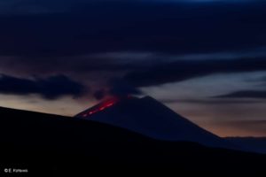
Kīlauea Volcano Summit
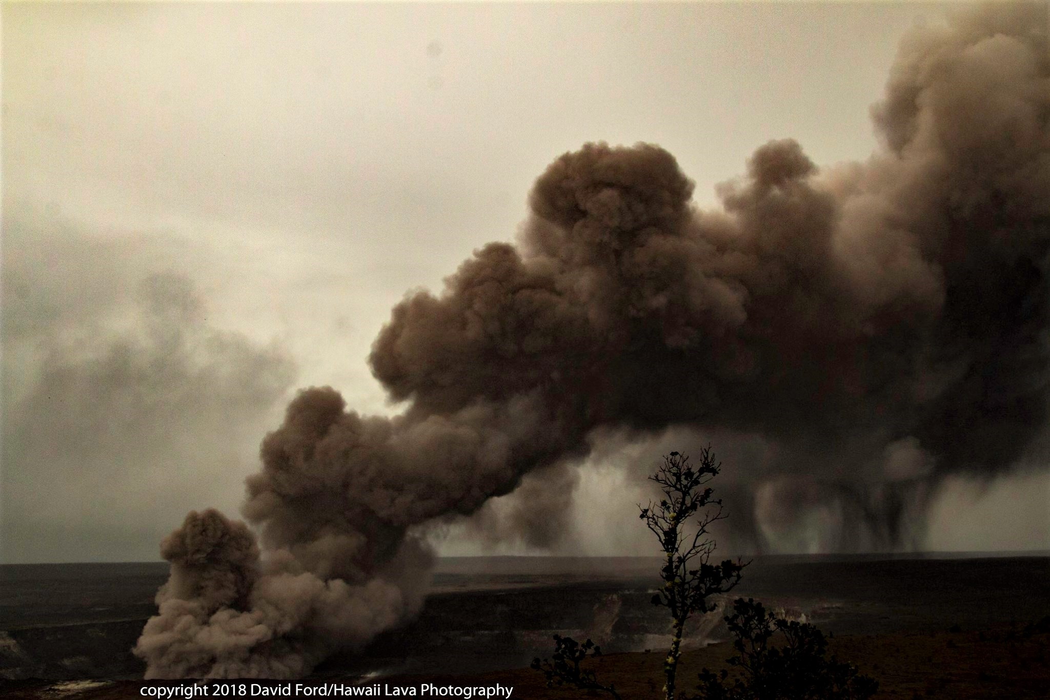
Tiltmeters at the summit of Kīlauea Volcano continue to record the deflationary trend of the past week and based on this and field observations, the lava lake level continues to drop. Intermittent rockfalls from the steep crater walls have generated small ash clouds throughout the day. More explosive activity generating larger ash clouds remains possible.
Earthquake activity in the summit remains elevated. Many of these earthquakes are related to the ongoing subsidence of the summit area and earthquakes beneath the south flank of the volcano.
Friday, May 11, 2018, 6:49 AM HST (Friday, May 11, 2018, 16:49 UTC)
Summary:
A pause in active eruption of spatter and lava along Kīlauea Volcano’s lower East Rift Zone continued through the night. However, earthquake activity and ground deformation continue and additional outbreaks in the general area of Leilani Estates are likely. Overnight, earthquake activity was concentrated on the downrift (east) side of the existing Leilani fissures. High levels of sulfur dioxide continue to be released from the fissure system.

Deflationary tilt at the summit of the volcano continues and seismicity remains elevated. This morning, a steady plume of steam is rising from the Overlook vent. It is expected that occasional rockfalls into the deep vent will produce intermittent, low-level ash emissions. Depending on wind conditions, dustings of ash may occur in the Kilauea summit area and downwind. More energetic ash emissions are possible.
USGS/HVO continues to monitor the situation at the summit and the lower East Rift Zone 24/7 in coordination with Hawaii County Civil Defense and other authorities. Field crews are onsite in the Leilani Estates area this morning examining the fissure vents and searching for any signs of new or resumed activity.
Friday, May 11, 2018, 4:39 PM HST (Saturday, May 12, 2018, 02:39 UTC)
Lower East Rift Zone Eruption
Volcanic unrest in the lower East Rift Zone of Kīlauea Volcano continues. While no lava has been emitted from any of the 15 fissure vents since May 9, earthquake activity, ground deformation, and continuing high emission rates of sulphur dioxide indicate additional outbreaks of lava are likely. The location of future outbreaks is not known with certainty, but could include areas both uprift (southwest) and downrift (northeast) of the existing fissures, or resumption of activity at existing fissures. Communities downslope of these fissures could be at risk from lava inundation.

Residents in lower Puna should remain informed and heed Hawaii County Civil Defense closures, warnings, and messages
Kīlauea Volcano Summit
Tiltmeters at the summit of Kīlauea Volcano continue to record deflationary tilt. Based on this and field observations of the past two days, the lava lake level continues to drop. Rockfalls from the steep crater walls have generated small ash clouds mixed with white condensed water vapor intermittently throughout the day. These ash clouds have been relatively low concentration and have risen only a few thousand feet above the ground generating very localized ashfall. More explosive activity generating larger ash clouds remains possible.
Earthquake activity in the summit remains elevated. Many of these earthquakes are related to the ongoing subsidence of the summit area and earthquakes beneath the south flank of the volcano.
051118 County of Hawaii, Halemaumau ash alert:
A message from COUNTY OF HAWAII
The Hawaiian Volcano Observatory has cautioned about the possibility of an explosive eruption at Halemaumau.
This is caused by the withdrawal of lava from Halemaumau’s summit lake, which leads to a steam-driven eruption. Such an eruption could generate ash plumes as high as 20,000 feet. The area affected by ash plumes could be as wide as 12 miles.

At 9:17 a.m. HST, another weak ash plume rose from the Overlook Vent in Halema‘uma‘u crater, producing a slightly more energetic and darker plume. This second plume lacked the pink altered ash that was in the earlier plume, apparently consisting of more unaltered (therefore darker) rock fragments. This plume also was probably caused by rockfall into the deepening vent, not related to groundwater and steam-driven explosions.
Should this occur, the following are advised:
The danger from this eruption is ash fallout. The major response is to protect yourself from fallout.
If this event occurs while you are at home, stay indoors with the windows closed. Turn on your radio and listen for updates from authorities.
If you are in your car, keep the windows closed. Ash fallout may cause poor driving conditions, due to limited visibility and slippery driving conditions. Drive with extreme caution, or pull over and park.
After the hazard is passed, do check your home, and especially your catchment system, for any impact that may affect your water quality.
This is precautionary information for your safety in the event that there is a Halemaumau explosive event. We want everyone in the Volcano area to be ready, and to remain safe. Do keep yourself informed and on the alert.
Source : HVO
Photos : David Ford , Andrew Hara, Julie Alen Paul , Hvo .
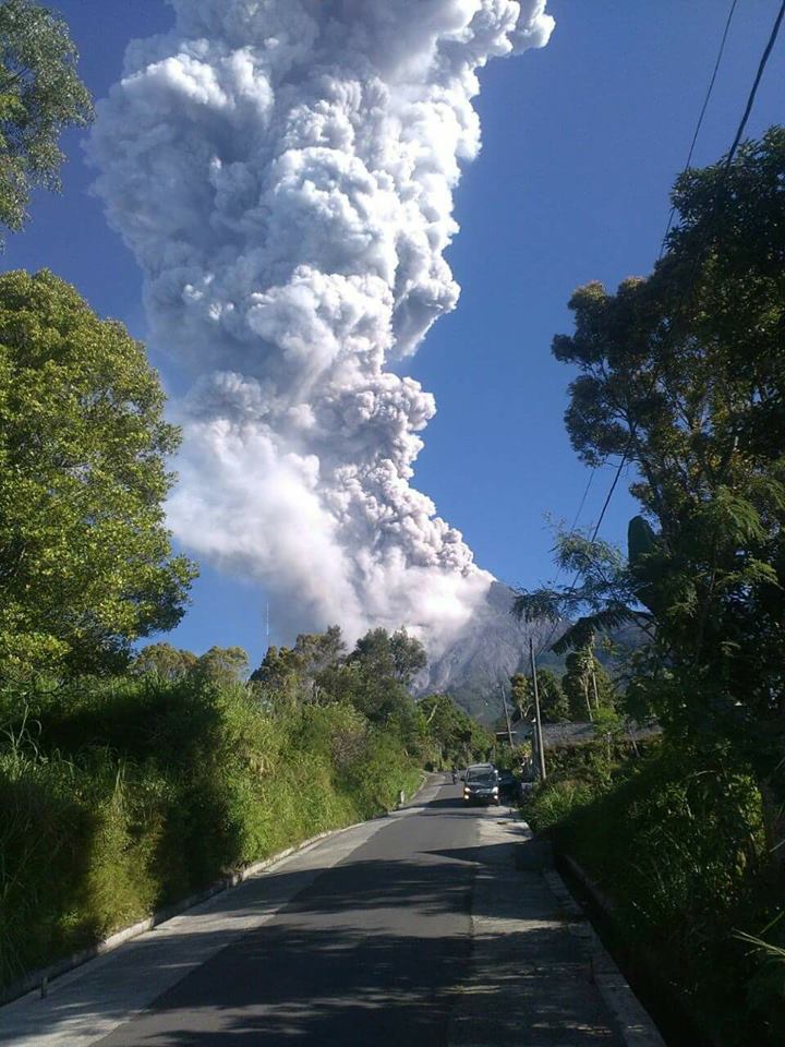
Merapi , Indonesia :
VOLCANO OBSERVATORY NOTICE FOR AVIATION – VONA.
Issued : May 11 , 2018 .
Volcano: Merapi (263250)
Current Aviation Colour Code: YELLOW
Previous Aviation Colour Code: red
Source: Merapi Volcano Observatory
Notice Number: 2018MER02
Volcano Location: S 07 deg 32 min 31 sec E 110 deg 26 min 31 sec
Area: Special Region of Yogyakarta, Indonesia
Summit Elevation: 9498 FT (2968 M)
Volcanic Activity Summary:
Eruption and ash emission is not continuing.
Volcanic Cloud Height:
Ash cloud not visible.
Other Volcanic Cloud Information:
Ash-cloud has dissipated.
The seismographs, dated May 9, 2018 have detected two volcanic earthquakes (VT) and eight events. On May 10, volcanic earthquakes were detected four times. On May 11, from 00:00 to 08:00, 1 earthquake was detected as well as a multi-phase earthquake.
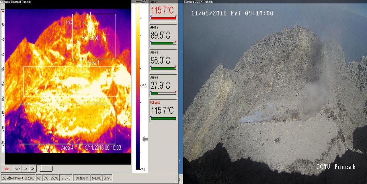
The result of the monitoring of the crater temperature, about 2 hours before the eruption, showed an increase in the crater in zone 3 (inside the crater) which went from 38.2 oC to 01 o’clock at 90.6oC at 08:30 WIB.
The deformation of G. Merapi that was instrumentally monitored using EDM and GPS did not show any significant change.
Based on the visual observation, the volcanic eruption of Merapi occurred on May 11, 2018 at 07:40 begins with a small roar, felt by a vibration around the observation post of G. Merapi of Babadan with a duration of 10 minutes. The height of the eruption column is 5.5 km above the summit. There was a shower of ash and fine sand around the G. Merapi observation post at Kaliurang. The rash occurred once and was not followed by a second rash.
After the eruption, recorded seismicity did not change and the temperature of the crater decreased.
CONCLUSION:
1. It is concluded that the current eruption is a minor eruption triggered by the accumulation of volcanic gases and will likely not be followed by other eruptions.
2. The activity status of G. Merapi remains at the « NORMAL » level.
RECOMMENDATIONS:
1. So far, Merapi activity has calmed down, people are encouraged to stay calm.
2. The escalation activity of G. Merapi is recommended only from Pasarbubar, except for the interest of investigation and research related to disaster mitigation efforts. The morphological state of G. Merapi is currently subject to landslides, so it is very dangerous for the safety of climbers.
3. If there is a significant change in Merapi volcano activity, then G. Merapi’s activity level will be reviewed shortly.
ANNEX
Dome conditions:
Source : Magma , Vsi .
Photo : Meme Comic Jawa
Piton de la Fournaise , La Réunion :
Activity Bulletin from Friday, May 11, 2018 at 3:00 pm (local time).
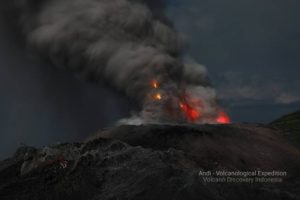
The eruption started on April 27, 2018 at 23:50 local time continues. The intensity of the volcanic tremor (indicator of surface eruptive intensity) has remained relatively stable over the last 24 hours.
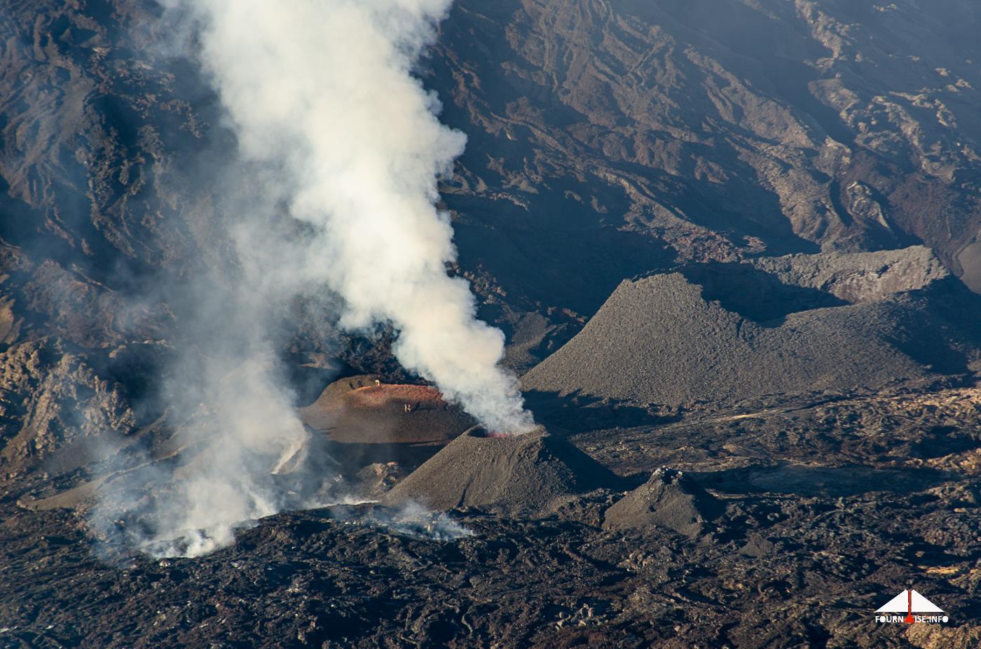
– The surface flows estimated from the satellite data, via the HOTVOLC platform (OPGC – Clermont Ferrand), recorded today were <2 m3 / s.
– No significant deformation is recorded.
– No volcano-tectonic earthquake has been recorded during the last 24 hours under the Piton de la Fournaise building.
Source : OVPF
Photo : Fournaise info
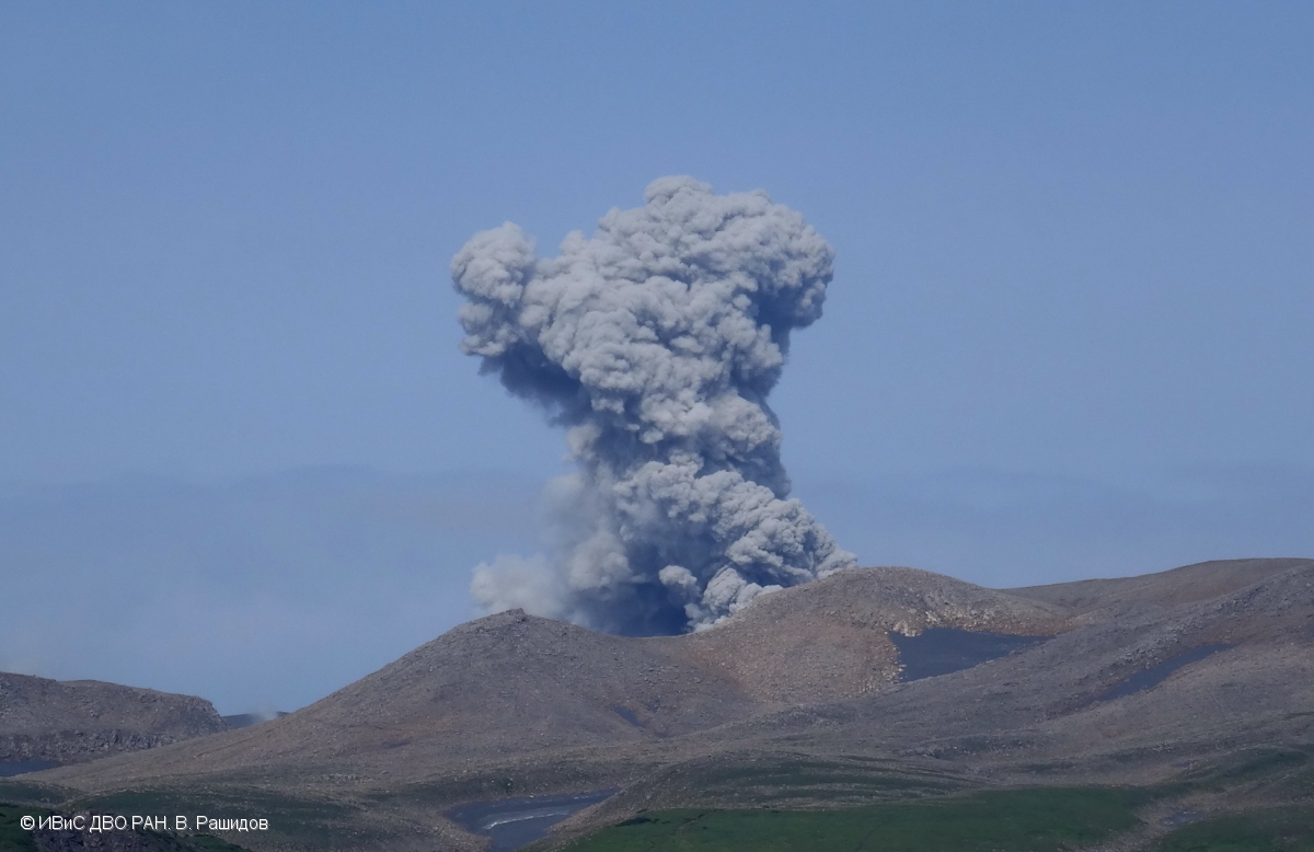
Ebeko , Kamchatka :
50.69 N, 156.01 E;
Elevation 3792 ft (1156 m)
Aviation Colour Code is ORANGE
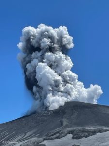
A moderate gas-steam with some amount of ash activity of the volcano continues. Ash explosions up to 16,400 ft (5 km) a.s.l. could occur at any time. Ongoing activity could affect low-flying aircraft and airport of Severo-Kurilsk.
Explosive event of Ebeko volcano on 10 August, 2017.
A moderate explosive activity of the volcano continues. According to visual data by volcanologists from Severo-Kurilsk, explosions sent ash up to 2.4 km a.s.l. on 04 and 06-10 May. Satellite data by KVERT showed the volcano was quiet or obscured by clouds.
Source : Kvert
Photo : V. Rashidov, IVS FEB RAS , 10/8/2017
Chiles / Cerro Negro , Colombia :
Subject: Activity bulletin of Chiles and Cerro Negro volcanoes
The level of activity of volcanoes is maintained at the level:
■ YELLOW LEVEL (III): Changes in the behavior of volcanic activity
On the activity monitoring of Chiles and Cerro Negro volcanoes, the Geological Survey of Colombia (CGT) reports that:
For the period between May 1 and May 7, 2018 and the previous week, seismicity in the Chile – Cerro Negro volcanoes region showed a slight increase in seismicity associated with rock fracturing.
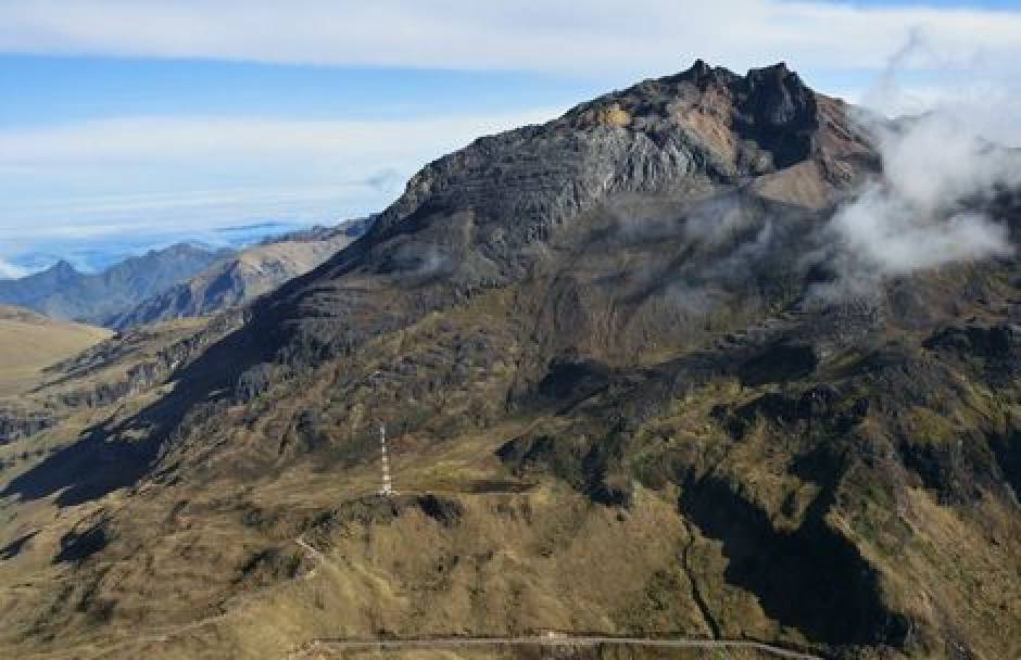
Most of the fracture events were located in the southwestern areas up to 6 km from the epicentral distance and further south-east of the Chiles volcano, at epicentral distances of up to 13 km, with depths of less than 9 km from the summit (4700 m). The maximum local magnitude was M2.4 on the Richter scale recorded on May 2nd at 12:38 pm. No events were reported as felt.
The Colombian Geological Service and the GEOPHYSICAL INSTITUTE OF ECUADOR’S NATIONAL POLISHING SCHOOL closely monitor the evolution of this seismic and volcanic activity and will report immediately on the changes detected.
Source : Ingeominas