28 Mai 2018. EN. Pu’u ‘Ō’ō / Kilauea , Turrialba , Poas , Arenal , Dukono , Piton de la Fournaise .
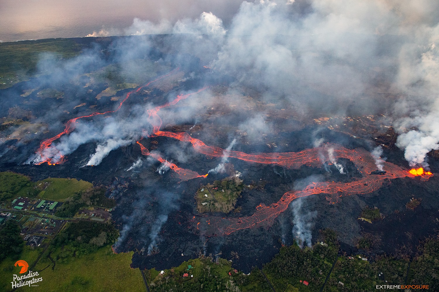
28 Mai 2018.


Pu’u ‘Ō’ō / Kilauea , Hawai :

Saturday, May 26, 2018, 11:42 PM HST (Sunday, May 27, 2018, 09:42 UTC)

19°25’16 » N 155°17’13 » W,
Summit Elevation 4091 ft (1247 m)
Current Volcano Alert Level: WARNING
Current Aviation Color Code: RED

Kīlauea Volcano Lower East Rift Zone:

Vigorous eruption of lava continues from the lower East Rift Zone fissure system in the area of Leilani Estates and Lanipuna Gardens. As of this morning, almost 2400 acres have been covered by new lava.

Fissures 22, 6, and 13 are feeding lava flows moving southeast to the coast southwest of Pohoiki. At midday today, two ocean entries were active. Over the past 24 hours, channels feeding these ocean entries have diminished somewhat in vigor, however the laze plume generated remains significant.

Fissure 21 is feeding an ‘a’ā flow that has advanced to the northeast and this afternoon crossed Pahoa Pohoiki Road onto PGV property. Fissure 7 is feeding a flow that has turned south toward the coast, and at dusk the lava was cascading into the Pawaii crater, adjacent to the western margin of the fissure 6 flow that feeds one of the ocean entries.
HVO field crews are on site tracking the fountains, lava flows, and spattering from multiple fissures as conditions allow and reporting information to Hawaii County Civil Defense. Crews are also checking on the status of ground cracks on Highway 130.

Volcanic gas emissions remain very high from the fissure eruptions. Trade winds are expected to diminish Sunday evening, which could expand the area impacted by vog.

Magma continues to be supplied to the lower East Rift Zone. Earthquake locations have not moved farther downrift in the past few days and the number of located earthquakes remains low.
Additional ground cracking and outbreaks of lava in the area of the active fissures are possible. Residents downslope of the region of fissures should heed all Hawaii County Civil Defense messages and warnings.

USGS/HVO continues to monitor the lower East Rift Zone activity 24/7 in coordination with Hawaii County Civil Defense.

Kīlauea Volcano Summit:

Ash continued to erupt intermittently from the Overlook crater at the Kīlauea summit. Observations from the ground and by UAV during the past week have documented retreat of the Overlook crater wall due to collapse of the steep enclosing walls and rim. Trade winds took the ash clouds primarily to the southwest. Trade winds are expected to diminish Sunday evening and communities around the summit area could see ashfall.

Aerial view of Kīlauea Volcano’s summit caldera and an ash plume billowing from Halema‘uma‘u, a crater within the caldera. The USGS–Hawaiian Volcano Observatory and Hawai‘i Volcanoes National Park’s Jaggar Museum are visible on the caldera rim (center right); Kīlauea Military Camp can be seen in the lower right. Photo courtesy of the Civil Air Patrol.


Earthquakes in the summit region continue as the summit area subsides and adjusts to the withdrawal of magma.
Additional explosive events that could produce minor amounts of ashfall downwind are possible at any time. Volcanic gas emissions at the summit remain high.

Sunday, May 27, 2018, 6:51 AM HST (Sunday, May 27, 2018, 16:51 UTC)

Kīlauea Volcano Lower East Rift Zone

Vigorous eruption of lava continues from the lower East Rift Zone fissure system in the area of Leilani Estates and Lanipuna Gardens.
Fissures 22 and 13 continue to feed lava flows extending south to the lava ocean entry. Signals recorded on stations in the LERZ indicate that the lava ocean entry remained active overnight.

Fissure 21 is feeding an ‘a’ā flow that has continued to advance to the northeast on PGV property. However, the rate of advance has slowed overnight coincident with an observed decline in the vigor of fountaining at Fissure 21. Fissure 7 activity has increased overnight, producing a large spatter rampart over 100 feet tall from fountains reaching 150-200 feet. The fountains fed a perched pāhoehoe flow 20-40 feet thick, and ultimately a flow that had turned south toward the coast last night.

Large cracks were observed overnight on Kupono St. about 360 yards north of Malama St, near Fissure 9. Fissure 8 had three vents active overnight that were spattering and flaming, and have doubled in size over the past 24 hours. Fissure 6 was inactive overnight.
HVO field crews are on site tracking the fountains, lava flows, and spattering from multiple fissures as conditions allow and reporting information to Hawaii County Civil Defense. Crews are also checking on the status of ground cracks on Highway 130.

Sunday, May 27, 2018, 6:20 PM HST (Monday, May 28, 2018, 04:20 UTC)

Kīlauea Volcano Lower East Rift Zone

Fissures 22 and 13 continue to feed lava flows extending south to the lava ocean entry. Signals recorded on stations in the LERZ indicate that the lava ocean entry remained active overnight. This morning, lava activity at both vents has diminished and the ocean entries are weaker than yesterday. Fissure 6 is no longer active. Fissure 21 has been intermittently active.
Fissure 7 activity is very active, producing a large spatter rampart over 100 feet tall from fountains reaching 150-200 feet. The fountains fed two perched channels–the north channel fed a lava flow that advanced toward pad E of the PGV property and the south channel a flow that was advancing to the southeast along the west border of the fissure 22 flow.


he eruption is once again more voluminous than previously observed, and massive rivers are flowing through lower Leilani and Lanipuna, toward the sea. Fissure 7 on Makamae is going off with huge fountains… 300-500’… and a fissure between Nohea and Kupono is beginning to effuse a good amount of lava, with most of it, flowing into a deep crack that had formed between homes.

The Fissure 7 north channel fed a flow that advanced into PGV property and approached pad E before it stalled this morning; however, the flow was refreshed by lava from the vent and, about noon, started to advance again covering a portion of pad E and also producing a narrow flow to the north of pad E. These flows continue to be active as of this posting

HVO field crews are on site tracking the fountains, lava flows, and spattering from multiple fissures as conditions allow and reporting information to Hawaii County Civil Defense. Crews are also checking on the status of ground cracks on Highway 130.

Volcanic gas emissions remain very high from the fissure eruptions. Trade winds are expected to diminish Sunday evening, which could expand the area impacted by vog.


USGS/HVO continues to monitor the lower East Rift Zone activity 24/7 in coordination with Hawaii County Civil Defense.

Kīlauea Volcano Summit

Ash continued to erupt intermittently from the Overlook crater, within Halemaʻumaʻu crater, at the Kīlauea summit, the largest occurred around noon producing an ash column to nearly 10,000 ft. Earthquakes in the summit region continue as the summit area subsides and adjusts to the withdrawal of magma.


Source : HVO.

Photos : Andrew Hara , USGS.

Vidéos : Big Island Vidéo News .


Turrialba , Poas , Arenal , Costa Rica :

Daily report on the state of the volcanoes of Turrialba, Poás and Arenal: May 25, 2018
Updated at 1 6:30 pm

Turrialba Volcano:
The seismic activity over the last 24 hours continuously has a relatively low level and is characterized by the recording of frequent low amplitude long period (LP) volcanic earthquakes, very low amplitude and short duration volcanic tremors. duration.
These earthquakes are associated with the movements of fluids (water, gas and / or magma) inside the volcanic massif.

In May, the fumaroles became more vigorous with production of steam columns, gas and volcanic aerosols from 500 to nearly 1000 meters above the top of the volcano. No rash or ash emission was observed or reported. Some people have reported the perception of sulfur smell in Coronado and San Rafael de Heredia. During the last 24 hours, the winds over the volcano scattered the volcanic plume mainly north-northwest, to the region of Braulio Carrillo, Guápiles, Sarapiqui, Ciudad Quesada. Yesterday, May 24, 2018, NASA’s omi-AURA satellite imagery shows a SO2 rich plume emitted by the spreading Turrialba volcano in the north-west of the country.

Poas Volcano:
The level of volcanic seismic activity is very low and is mainly due to the hydrothermal activity and the low temperature fumarole degassing through the crater. Degassing is persistent but passive and consists of low temperature fumaroles rich in water vapor, with a relatively low content of magmatic gases such as CO2, SO2 and H2S.

During the last 24 hours, the winds over the volcano dispersed the volcanic plume mainly north and northwest of Poas Volcano National Park, and towards Rio Cuarto, Pueblo Nuevo, Cariblanco, San Miguel de Sarapiqui, Pital , Buenos Aires.

Arenal Volcano:
During the second half of May 2018, the Arenal volcano showed few fumaroles rich in water vapor rising a few tens of meters above the top of the volcano due to the abundant meteoric water that is infiltrated inside the volcano which still has the residual heat of the surface magma still being cooled and crystallized.

Source : Ovsicori.

Photos : RSN , Ovsicori.


Dukono , Indonesia :

VOLCANO OBSERVATORY NOTICE FOR AVIATION – VONA.

Issued: May 27 , 2018.
Volcano:Dukono (268010)
Current Aviation Colour Code: ORANGE
Previous Aviation Colour Code: orange
Source: Dukono Volcano Observatory
Notice Number: 2018DUK82
Volcano Location: N 01 deg 41 min 35 sec E 127 deg 53 min 38 sec
Area: North Maluku, Indonesia
Summit Elevation: 3933 FT (1229 M)

Volcanic Activity Summary:
Eruption with volcanic ash cloud at 23h07 UTC (08h07 local).

Volcanic Cloud Height:
Best estimate of ash-cloud top is around 5853 FT (1829 M) above sea level, may be higher than what can be observed clearly. Source of height data: ground observer.

Other Volcanic Cloud Information:
Ash cloud moving to West.

Remarks:
Eruption and ash emission is continuing.

Activity Level at Level II  (WASPADA). The Dukono (1229 m above sea level) has a continuous eruption.
Since yesterday until this morning, visually the volcano can be observed clearly until the appearance of fog. The smoke / ash from the crater is white to gray, from low to medium pressure and strong intensity with a height of 600 m above the summit. The eruption was observed with a height of 400 m above the peak with a color of white to gray smoke. The wind was faintly westerly.

According to the seismograph, dated May 27, 2018, it was recorded:
1 eruption earthquake- 3 volcanic earthquakes.
1 Tectonic Earthquake
Continuous tremor with a maximum amplitude of 0.5-18 mm (dominant value of 2 mm)

Recommendations:
Communities around G. Dukono and visitors / tourists should avoid activities, climbing and approaching Malupang Warirang crater within 2 km radius

Source : Magma Indonésie .

Photo : 80 Jours Voyage / S Chermette.


Piton de la Fournaise , La Réunion :

Activity Bulletin from Sunday, May 27, 2018 at 3:00 pm (local time).

The eruption started on April 27, 2018 at 23:50 local time continues. The intensity of the volcanic tremor (indicator of eruptive intensity at the surface) continues to decrease gradually

– The surface flows could not be estimated from the satellite data today because of the cloud cover on the volcano.
– A volcano-tectonic earthquake has been recorded in the past 24 hours under the Piton de la Fournaise building

Alert level: Alert 2-2 – Eruption in the Enclos.

Source : OVPF

Photo : Fournaise infos