October 25 , 2022.
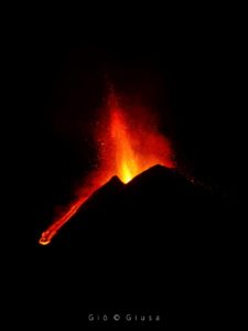
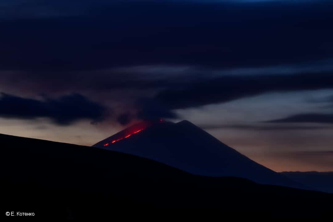
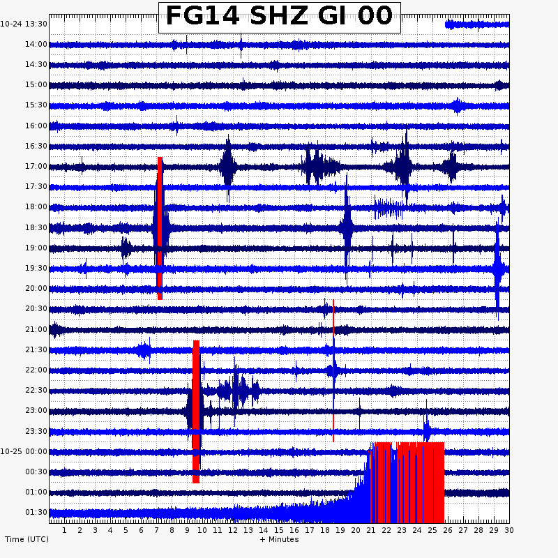
Russia / Kuril Islands , Alaid :
VOLCANO OBSERVATORY NOTICE FOR AVIATION (VONA)
Issued: October 24 , 2022
Volcano: Alaid (CAVW #290390)
Current aviation colour code: ORANGE
Previous aviation colour code: orange
Source: KVERT
Notice Number: 2022-145
Volcano Location: N 50 deg 51 min E 155 deg 33 min
Area: Northern Kuriles, Russia
Summit Elevation: 2339 m (7671.92 ft)
Volcanic Activity Summary:
An explosive activity of the volcano continues. Satellite data by KVERT showed an ash plume extended about 72 km to the east-north-east of the volcano.
A moderate eruptive activity of the volcano continues. Ash explosions up to 8 km (26,200 ft) a.s.l. could occur at any time. Ongoing activity could affect international and low-flying aircraft.
Volcanic cloud height:
3000-3500 m (9840-11480 ft) AMSL Time and method of ash plume/cloud height determination: 20221023/2320Z – Himawari-8 14m15
Other volcanic cloud information:
Distance of ash plume/cloud of the volcano: 72 km (45 mi)
Direction of drift of ash plume/cloud of the volcano: ENE / azimuth 71 deg
Time and method of ash plume/cloud determination: 20221023/2320Z – Himawari-8 14m15
Source : Kvert
Photo : E. Kotenko
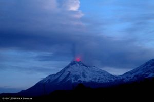
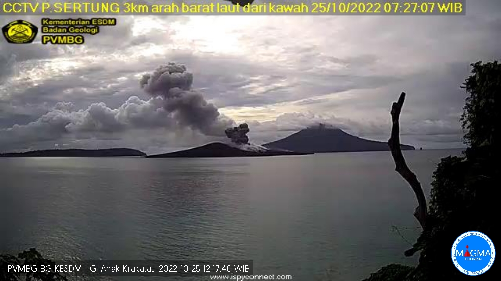
Indonesia , Anak Krakatau :
Mount Anak Krakatau had eruptions on Tuesday, October 25, 2022, including one at 07:27 WIB with an ash column height observed at ± 200 m above the peak (± 357 m above sea level) . It is observed that the ash column is black with a thick intensity towards the North-East. This eruption was recorded on a seismograph with a maximum amplitude of 50 mm and a duration of 21 seconds.
VOLCANO OBSERVATORY NOTICE FOR AVIATION – VONA
Issued : October 24 , 2022
Volcano : Anak Krakatau (262000)
Current Aviation Colour Code : ORANGE
Previous Aviation Colour Code : orange
Source : Anak Krakatau Volcano Observatory
Notice Number : 2022KRA75
Volcano Location : S 06 deg 06 min 07 sec E 105 deg 25 min 23 sec
Area : Lampung, Indonesia
Summit Elevation : 502 FT (157 M)
Volcanic Activity Summary :
Eruption with ash clouds at 10:57 UTC (17:57 local time). The eruption lasted for 32 seconds
Volcanic Cloud Height :
Best estimate of ash-cloud top is around 982 FT (307 M) above sea level, may be higher than what can be observed clearly. Source of height data: ground observer.
Other Volcanic Cloud Information :
Visuals directly from the cctv were observed eruptions with the color of the thick black eruption smoke 150m from the top of the volcano, the wind direction slowly to the northeast.
Remarks :
Eruption recorded on seismogram with maximum amplitude 20 mm and maximum duration 32 second.
Source : Magma Indonésie .
Guatemala , Fuego :
LAHAR IN THE CENIZA RAVINE, TRIBUTARY TO THE ACHIGUATE RIVER
The rains in the area of the Fuego volcanic complex are currently generating a lahar in the Barranca Ceniza, a tributary of the Achíguate River, with weak to moderate characteristics, but with the probability of increasing in the next few minutes due to the persistent rains In the region.
The lahar descends fine and hot volcanic materials, in addition to carrying branches and tree trunks, as well as blocks from 30 cm to 1.5 meters in diameter. The rains of the past few days have kept the volcanic deposits saturated with humidity, so that lahars will continue to be generated in the afternoon and evening.
Source : Insivumeh .
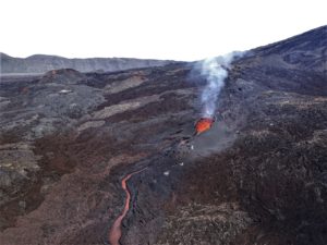
Peru , Sabancaya :
Analysis period: from October 17, 2022 to October 23, 2022, Arequipa, October 24, 2022.
Alert level: ORANGE
The Geophysical Institute of Peru (IGP) reports that the eruptive activity of the Sabancaya volcano remains at moderate levels, that is to say with the recording of an average of 40 daily explosions, with columns of ash and of gas up to 2.9 km altitude above the summit of the volcano and their subsequent dispersion. Therefore, for the following days, no significant change is expected in eruptive activity.
The IGP recorded and analyzed the occurrence of 291 earthquakes of volcanic origin, associated with the circulation of magmatic fluids inside the Sabancaya volcano. An average of 40 explosions was recorded daily, in addition to recording Volcano-Tectonic (VT) type events associated with rock fracturing inside the Sabancaya volcano.
Monitoring the deformation of the volcanic structure using GNSS techniques (processed with fast orbits) does not show any significant anomalies. However, in general, an inflation process was observed in the northern sector (surroundings of the Hualca Hualca volcano). Visual surveillance identified columns of gas and ash up to 2.9 km above the summit of the volcano, which were dispersed towards the eastern, southeast and northeast sectors of Sabancaya. . Satellite recordings have identified the presence of 6 thermal anomalies, with a maximum value of 15 MW, associated with the presence of a lava body on the surface of the volcano’s crater.
RECOMMENDATIONS
• Keep the volcanic alert level orange.
• Do not approach within a radius of less than 12 km from the crater.
Source : Cenvul
Photo : Galeria del Ministerio de Defensa del Perú.
Mexico , Popocatepetl :
October 23, 11:00 a.m. (October 23, 4:00 p.m. GMT)
During the past 24 hours, according to the monitoring systems of the Popocatépetl volcano, 27 exhalations have been detected, accompanied by water vapor, volcanic gases and slight amounts of ash. In addition, 635 minutes of tremor, including 300 minutes of low amplitude and high frequency and 335 minutes of harmonic type tremor were recorded.
At the time of this report, the volcano has good visibility, observing a slight emission of gas.
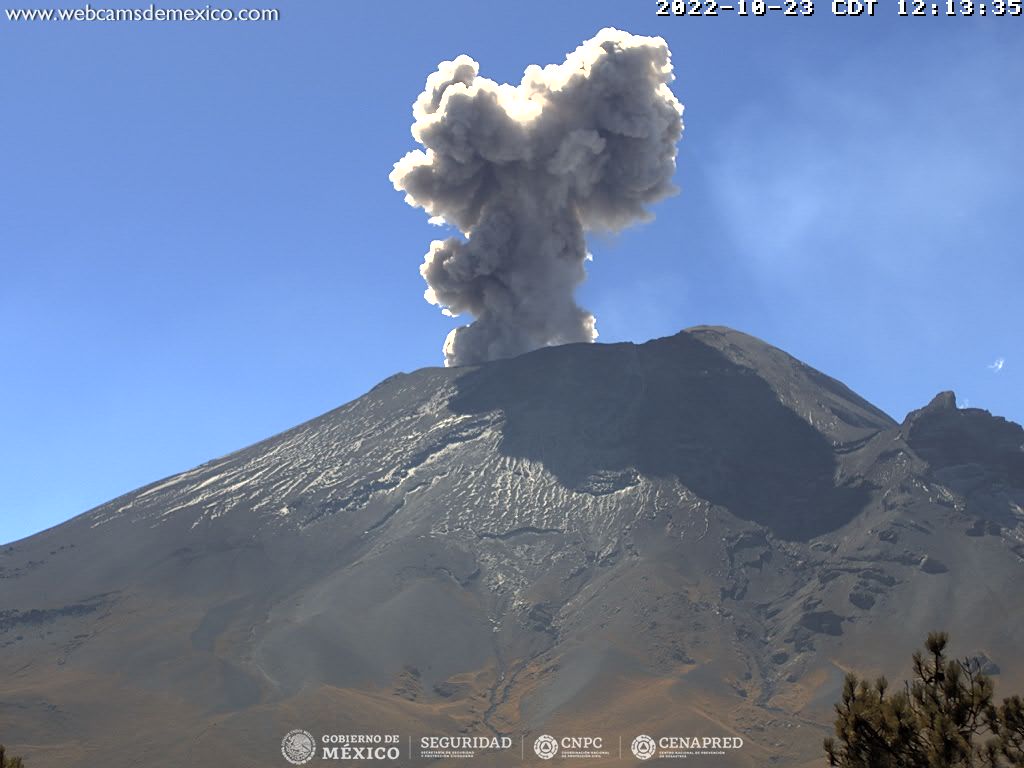
CENAPRED urges NOT TO APPROACH the volcano and especially the crater, because of the danger of falling ballistic fragments and, in case of heavy rains, to stay away from the bottom of the ravines because of the danger of mudslides and of debris.
The Popocatépetl volcanic alert traffic light is in YELLOW PHASE 2.
Source : Cenapred.