May 15 , 2023.
Italy / Sicily , Etna :
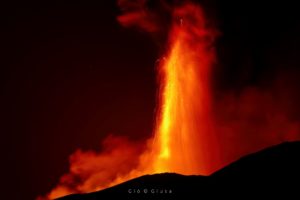
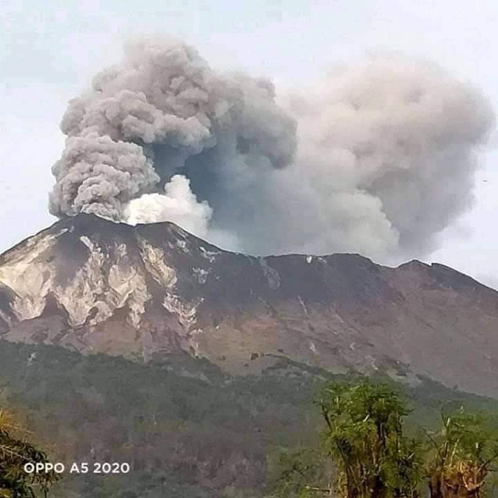
Communique on the activity of Etna, May 14, 2023, 08:40 (06:40 UTC).
The National Institute of Geophysics and Volcanology, Osservatorio Etneo, communicates that the monitoring networks recorded at 08:39 (06:39 UTC), a sudden explosion with emission of ash.
Communique on the activity of Etna, May 14, 2023, 09:01 (07:01 UTC).
The National Institute of Geophysics and Volcanology, Osservatorio Etneo, communicates that through the surveillance cameras at 06:36 UTC an explosion was observed produced by the Southeast crater which generated a modest emission of ash which is quickly dispersed in the summit area. No further explosions followed this event. From the seismic point of view, there are no significant variations. The high frequency GPS network shows no significant variation.
Further updates will be communicated promptly and in any case within 3 hours of this press release.

Communique on the activity of Etna, May 14, 2023, 6:28 p.m. (16:28 UTC).
The National Institute of Geophysics and Volcanology, Osservatorio Etneo, communicates that the monitoring networks recorded at 6:27 p.m. (4:27 p.m. UTC), the end of volcanic activity.
Further updates will be communicated soon
After a relatively calm week, the Southeast crater of Etna produced a new explosion, very similar to that of May 6 evening, emitting a small puff of ash. For now it is, this time also, a single event, but the intense degassing of the vent continues, the same as the last time, which corresponds to what during the activity of 2021-2022, we called « the eastern mouths » (in earlier times, « u puttusiddu). Explosions of this kind can occur at any time, without warning. There have been cases where such activity has ended after a few explosions.

For now, there are no signs of impending larger activity: the magnitude of volcanic tremor is quite low, seismic activity is generally quite low, SO2 emissions remain modest, and inflation ( swelling) progresses very slowly.
Sources : INGV , Boris Behncke.
Photos : INGV , Gio Giusa.
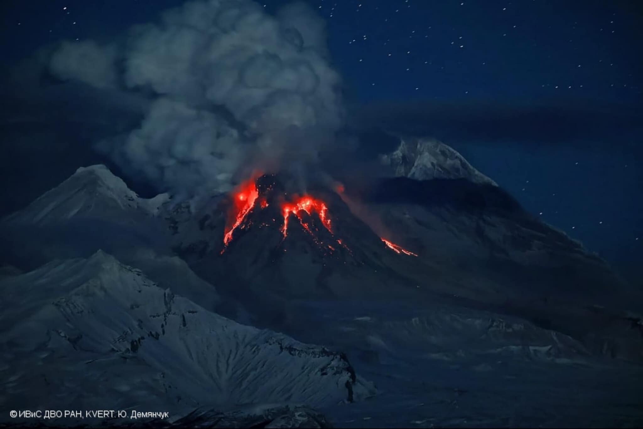
Kamchatka , Sheveluch :
VOLCANO OBSERVATORY NOTICE FOR AVIATION (VONA)
Issued: May 14 ,2023
Volcano: Sheveluch (CAVW #300270)
Current aviation colour code: ORANGE
Previous aviation colour code: orange
Source: KVERT
Notice Number: 2023-68
Volcano Location: N 56 deg 38 min E 161 deg 18 min
Area: Kamchatka, Russia
Summit Elevation: 3283 m (10768.24 ft), the dome elevation ~2500 m (8200 ft)
Volcanic Activity Summary:
Satellite data by KVERT shows a strong wind lifts ash from the slopes of Sheveluch volcano, and a plume of resuspended ash extends 260 km to the east of the volcano.
An extrusive eruption of the volcano continues. A danger of ash explosions up to 10 km (32,800 ft) a.s.l. is remains. Ongoing activity could affect international and low-flying aircraft.
Volcanic cloud height:
3500 m (11480 ft) AMSL Time and method of ash plume/cloud height determination: 20230514/2050Z – Himawari-9 14m15
Other volcanic cloud information:
Distance of ash plume/cloud of the volcano: 260 km (162 mi)
Direction of drift of ash plume/cloud of the volcano: E / azimuth 100 deg
Time and method of ash plume/cloud determination: 20230514/2050Z – Himawari-9 14m15
Source : Kvert
Photo : Yu. Demyanchuck / IVS FEB RAS KVERT via Olga Girina.
Indonesia , Ili Lewotolok :
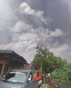
An eruption of G. Ili Lewotolok occurred on Monday, May 15, 2023 at 09:57 WITA with the height of the ash column observed at ± 600 m above the summit (± 2023 m above sea level) . The ash column was white, gray to black with a thick intensity, oriented to the East and Southeast. This eruption was recorded on a seismograph with a maximum amplitude of 20 mm and a duration of 46 seconds.
VOLCANO OBSERVATORY NOTICE FOR AVIATION – VONA
Issued : May 12 ,2023
Volcano : Ili Lewotolok (264230)
Current Aviation Colour Code : ORANGE
Previous Aviation Colour Code : orange
Source : Ili Lewotolok Volcano Observatory
Notice Number : 2023LEW025
Volcano Location : S 08 deg 16 min 19 sec E 123 deg 30 min 18 sec
Area : East Nusa Tenggara, Indonesia
Summit Elevation : 4554 FT (1423 M)
Volcanic Activity Summary :
Eruption with volcanic ash cloud at 01h57 UTC (09h57 local).
Volcanic Cloud Height :
Best estimate of ash-cloud top is around 6474 FT (2023 M) above sea level or 1920 FT (600 M) above summit. May be higher than what can be observed clearly. Source of height data: ground observer.
Other Volcanic Cloud Information :
Ash cloud moving from east to southeast. Volcanic ash is observed to be white to dark. The intensity of volcanic ash is observed to be thick.
Remarks :
Eruption recorded on seismogram with maximum amplitude 20 mm and maximum duration 46 second.
Source : Magma Indonésie.
Photo : Kodi Setiawan
Chile , Nevados de Chillan :
Seismology
The seismological activity of the period was characterized by the recording of:
90 VT-type seismic events, associated with rock fracturing (Volcano-Tectonics). The most energetic earthquake presented a local magnitude value (ML) equal to 1.5, located 4.7 km to the South-South-East and with a depth of 2.7 km from the active crater.
23 LP-type seismic events, associated with fluid dynamics within the volcanic system (Long Period). The most energetic earthquake presented a reduced displacement value (DR) of 4 cm2 and a local magnitude value (ML) equal to 1.2, located 0.6 km to the East-North-East and with a depth of 1.2 km from the active crater.
Fluid Geochemistry
Data on sulfur dioxide (SO2) emissions obtained by optical differential absorption spectroscopy (DOAS) equipment, corresponding to the Chillán station, installed 1.5 km south-southeast of the active crater , showed an average SO2 flux value of 398 ± 56 t/d, with a maximum of 682 t/d on April 25. This value is higher than that recorded last month and is considered normal for this volcanic system.
Satellite thermal anomalies
No thermal anomalies were reported according to the observation of volcanic activity in the mid-infrared (MIROVA). Similarly, no luminance anomaly was reported, based on the analytical processing of satellite images (Sentinel 2-L2A in combination of false color bands).
Geodesy
The geodetic activity of the period was characterized by:
– Subtle changes in GNSS line lengths, deformation rates do not exceed 0.5 cm/month.
– Slight changes in the vertical and horizontal components of the GNSS stations, without evidence of changes in the internal dynamics of the volcanic system, with rates that do not exceed 0.3 cm / month.
– No changes attributable to the internal alteration of the volcanic system related to deformation.
Surveillance cameras
The images provided by the fixed camera, installed near the volcano, recorded passive degassing, without pyroclastic emission, where the maximum height reached 180 m above the level of the crater on April 23.
Activity remained at levels considered low, suggesting stability of the volcanic system. The volcanic technical alert is maintained at:
GREEN TECHNICAL ALERT: Active volcano with stable behavior – There is no immediate risk
Source : Sernageomin.
Photo : josefauna ( archive).
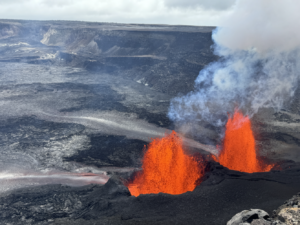
Hawaii , Kilauea :
Sunday, May 14, 2023, 8:58 AM HST (Sunday, May 14, 2023, 18:58 UTC)
19°25’16 » N 155°17’13 » W,
Summit Elevation 4091 ft (1247 m)
Current Volcano Alert Level: ADVISORY
Current Aviation Color Code: YELLOW
Activity Summary:
Kīlauea volcano is not erupting, and no active lava has been observed since March 7, 2023. Slow, steady inflation in the summit region continues, while summit seismicity remains elevated. No significant changes have been observed along either of the volcano’s rift zones over the past day.
Halemaʻumaʻu Crater Observations:
No active lava has been observed over the past day.

Summit Observations:
Slow, steady inflation continues. Overall, inflation at the summit of Kīlauea is higher than conditions preceding the January 5, 2023 summit eruption. Small flurries of earthquakes continue irregularly beneath Halemaʻumaʻu, Keanakākoʻi Crater, and the southern margin of Kaluapele (Kīlauea caldera) since April 16. Overall, rates of summit earthquakes remain elevated, and additional earthquake flurries are possible. The most recent sulfur dioxide (SO2) emission rate of approximately 135 tonnes per day was measured on May 3.
Rift Zone Observations:
No unusual activity has been noted along the East Rift Zone or Southwest Rift Zone; steady rates of ground deformation and seismicity continue along both. Measurements from continuous gas monitoring stations in the middle East Rift Zone—the site of 1983–2018 eruptive activity—remain below detection limits for SO2.
Source : HVO.
Photo : USGS/ M. Zoeller.