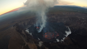
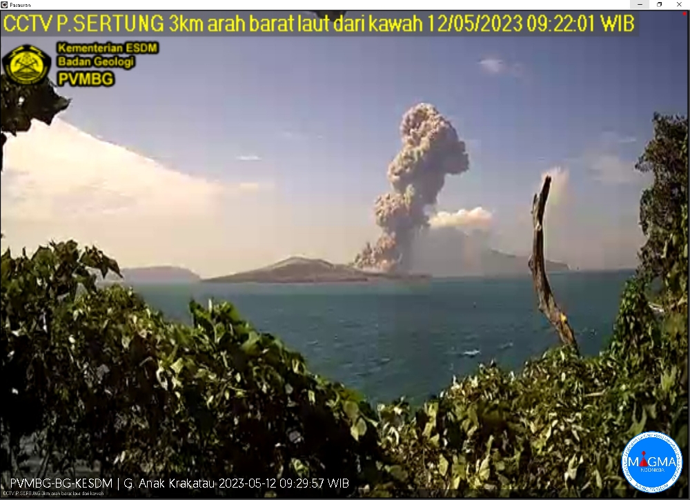
May 12 , 2023.
Indonesia , Anak Krakatau :
An eruption of Mount Anak Krakatau occurred on Friday May 12, 2023 at 09:20 WIB with the height of the ash column observed at ± 2500 m above the summit (± 2657 m above sea level). The ash column was observed to be gray with a thick intensity, oriented to the southwest. This eruption was recorded on a seismograph with a maximum amplitude of 70 mm and a duration of 42 seconds.
VOLCANO OBSERVATORY NOTICE FOR AVIATION – VONA
Issued : May 12 , 2023
Volcano : Anak Krakatau (262000)
Current Aviation Colour Code : ORANGE
Previous Aviation Colour Code : orange
Source : Anak Krakatau Volcano Observatory
Notice Number : 2023KRA049
Volcano Location : S 06 deg 06 min 07 sec E 105 deg 25 min 23 sec
Area : Lampung, Indonesia
Summit Elevation : 502 FT (157 M)
Volcanic Activity Summary :
Eruption with volcanic ash cloud at 02h20 UTC (09h20 local).
Volcanic Cloud Height :
Best estimate of ash-cloud top is around 8502 FT (2657 M) above sea level or 8000 FT (2500 M) above summit. May be higher than what can be observed clearly. Source of height data: ground observer.
Other Volcanic Cloud Information :
Ash cloud moving to southwest. Volcanic ash is observed to be gray. The intensity of volcanic ash is observed to be thick.
Remarks :
Eruption recorded on seismogram with maximum amplitude 70 mm and maximum duration 42 second
Source : Magma Indonésie.
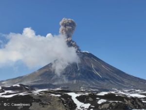
Kamchatka , Sheveluch :
56.64 N, 161.32 E;
Elevation 3283 m (10768 ft),
the dome elevation ~2500 m (8200 ft)
Aviation Colour Code is ORANGE
An extrusive eruption of the volcano continues. A danger of ash explosions up to 10 km (32,800 ft) a.s.l. is remains. Ongoing activity could affect international and low-flying aircraft.
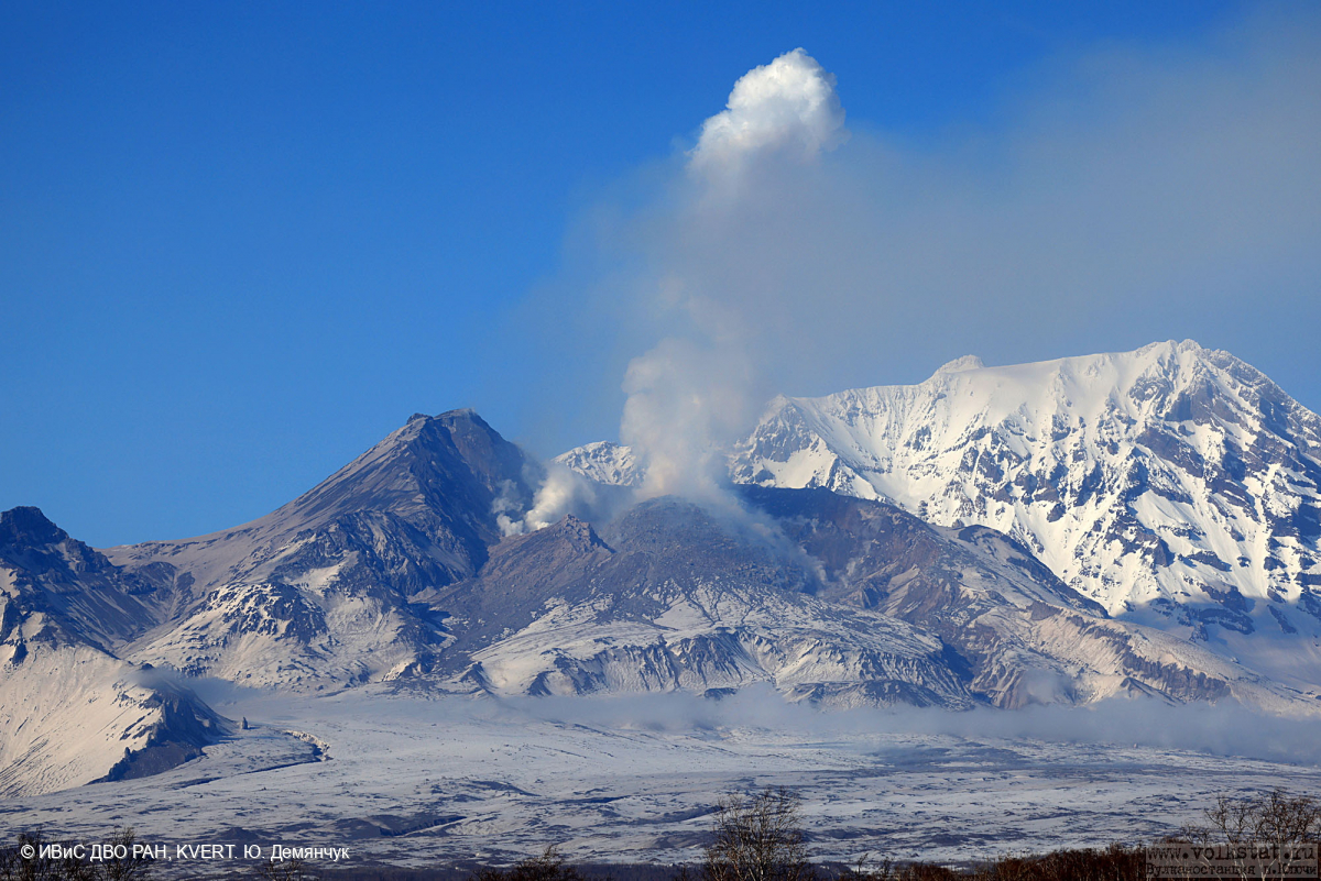
The growth of the lava dome in the explosive crater, formed during the paroxysmal eruption of the Sheveluch volcano on April 10-13, 2023, continues.
The extrusive volcanic eruption continues: lava blocks are squeezed out in the explosive crater of the Young Sheveluch, it is accompanied by powerful gas-steam activity, an incandescence of the lava dome, and sometimes hot avalanches and explosions. In the area of the Karan dome, powerful gas-steam activity is also observed, probably associated with the growth of a new lava dome. According to KVERT satellite data, on 08-09 May, the plume of resuspended ash, lifted by the wind from the field of pyroclastic flow deposits formed on the southeastern slope of the volcano during the April 10-13, 2023 eruption, extended 60 km west of the volcano; thermal anomalies were observed in the area of the active volcano crater and Karan dome all week.
Source : Kvert
Photo : Yu. Demyanchuk, IVS FEB RAS, KVERT
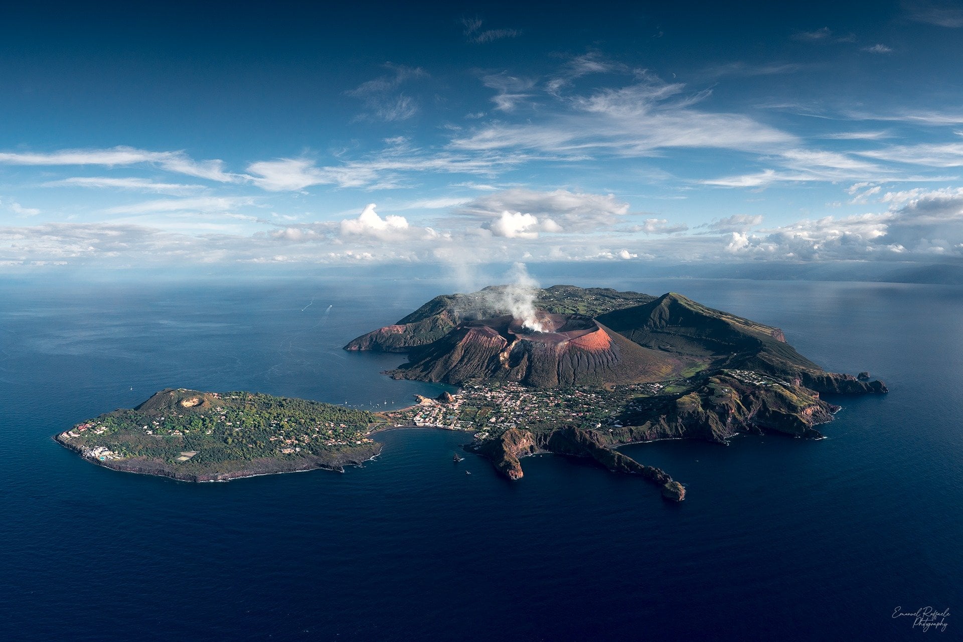
Italy , Vulcano :
WEEKLY BULLETIN, from May 01, 2023 to May 07, 2023. (issue date 09 May 2023)
ACTIVITY STATUS SUMMARY
In the light of the monitoring data, it is highlighted:
1) Temperature of the crater fumaroles: The temperature signal recorded on the edge of the crater is strongly disturbed by the intense rainfall events but always remains at high values.
2) CO2 fluxes in the crater area: CO2 fluxes in the summit area show a downward trend with values around 6000 g/m2/day
3) SO2 flux in the crater area: decreasing towards an average level
4) Geochemistry of fumarolic gases: There are no updates.
5) CO2 fluxes at the base of the La Fossa cone and in the Vulcano Porto area: The CO2 fluxes recorded at the sites of Rimessa, C. Sicilia show stable values, always above background levels. The P4max site displays medium-low values, while values close to the background noise are recorded on the Faraglione site.
6) Geochemistry of thermal aquifers: stable but still high temperature values are recorded in the Camping Sicilia well and do not show variations in conductivity values; in the Bambara well, no significant change in the monitored parameters was observed.
7) Local seismicity: Very low values of the event occurrence rate.
8) Regional seismicity: Low fracturing activity, only one earthquake was recorded, with a magnitude of 1.5.
9) Deformations – GNSS: The network of permanent GNSS stations has not recorded any significant variations
10) Deformations – Inclinometry: The inclinometric network did not record any significant variations.
11) Gravimetry: No significant change was recorded.
12) Other Comments: Mobile GNSS.
The time series acquired so far by the mobile GNSS network do not show significant variations around the Porto di Levante area.
CO2 FLOW IN THE CRATER AREA
Data from the VSCS station updated to May 03, 2023 show decreasing average values with values around 6000 g/m2/day.
The monthly average for April was 5206 g/m2/day, down from the previous month but still anomalous compared to average background values assessed over the past decade of observations and monitoring. . In the following months we will verify this drop to rule out that it was not caused by the unfavorable weather conditions recorded in April.
Source : INGV.
Photo : Emanuel Raffaele Photography
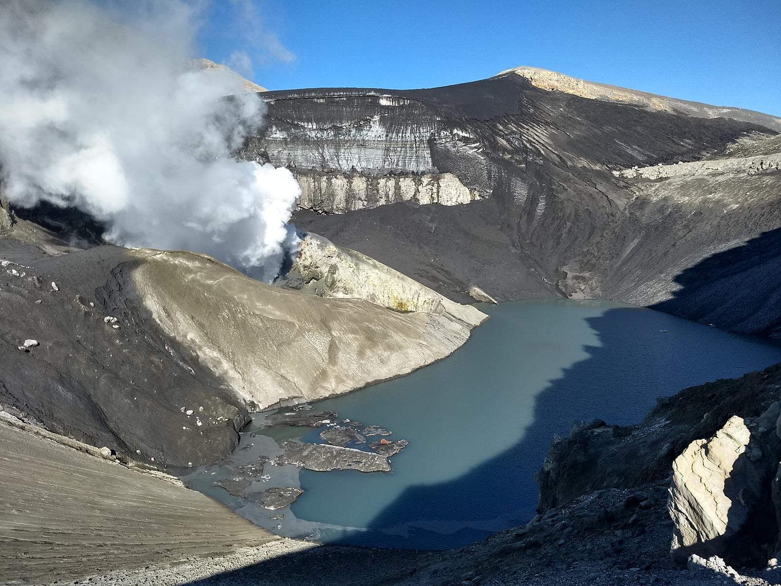
Chile , Copahue :
Seismology
The seismological activity of the period was characterized by the recording of:
27 VT-type seismic events, associated with rock fracturing (Volcano-Tectonics). The most energetic earthquake presented a local magnitude value (ML) equal to 1.5, located 8.6 km to the East-North-East and with a depth of 5.2 km from the crater .
2 LP-type seismic events, associated with fluid dynamics within the volcanic system (Long Period). The size of the largest earthquake assessed from the Reduced Displacement (DR) parameter was equal to 2 cm2.
1 HB-type seismic event, associated with both rock fracture and fluid dynamics within the volcanic system (Hybrid). This earthquake presented a reduced displacement value (DR) of 13 cm2 and a local magnitude value (ML) equal to 1.1, located 4.4 km to the West-South-West and with a depth 15.5 km from the crater.
Fluid Geochemistry
The sulfur dioxide (SO2) emission data obtained by the optical differential absorption spectroscopy (DOAS) equipment, corresponding to the Mellizas station, installed 6 km east-northeast of the active crater, have presented an average value of 376 ± 52 t/d, with a maximum value of 1173/d on April 18. According to the activity of the volcano, these values remain at levels considered low.
No anomalies in sulfur dioxide (SO2) emissions into the atmosphere have been reported in the area near the volcano, according to data published by the Tropospheric Monitoring Instrument (TROPOMI) and the Ozone Monitoring Instrument.
Satellite thermal anomalies
During the period, no thermal alert was recorded in the area associated with the volcanic edifice, according to data processed by Middle Infrared Observation of Volcanic Activity MIROVA, and by analytical processing of Sentinel 2-L2A satellite images, in combination of false color bands.
Geodesy
According to data provided by 4 GNSS stations in the volcanic area, no significant variation associated with volcanic deformation is observed during the evaluated period. The vertical displacement rates are almost nil, while the horizontal displacement rates remain at values below 0.5 cm/month.
Surveillance cameras
The images provided by the fixed camera, installed near the volcano, recorded regular degassing during the evaluated period, with a maximum column height of 80 meters on April 19.
Activity remained at levels considered low, suggesting stability of the volcanic system. The volcanic technical alert is maintained at:
GREEN TECHNICAL ALERT: Active volcano with stable behavior – There is no immediate risk
Source : Sernageomin
Photo : Carpediem1971
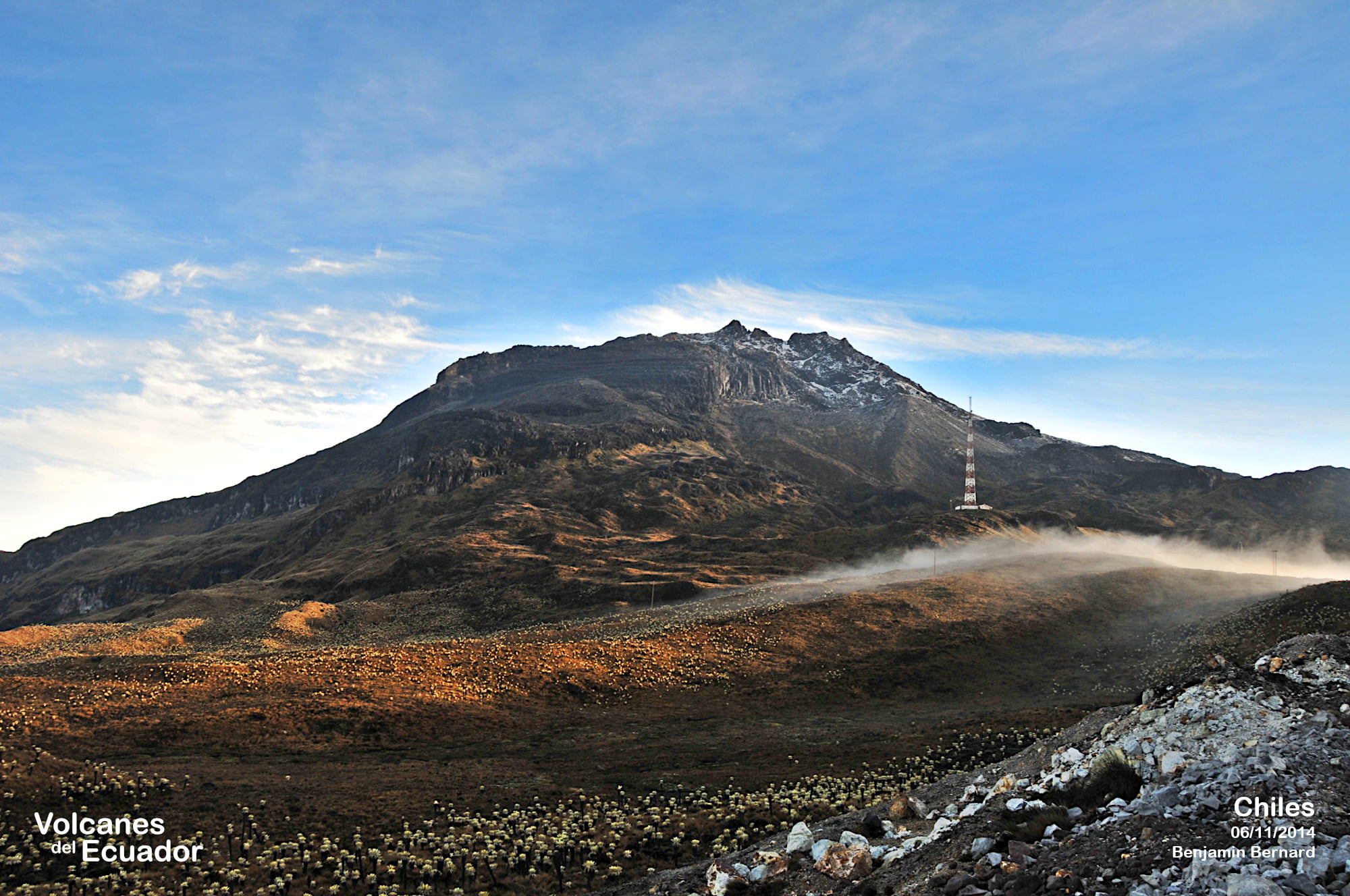
Colombia , Chiles / Cerro Negro :
Weekly activity bulletin of the Chiles and Cerro Negro Volcanic Complex (CVCCN)
Regarding the monitoring of the activity of the VOLCANOES CHILES AND CERRO NEGRO, the MINISTRY OF MINES AND ENERGY through the COLOMBIAN GEOLOGICAL SERVICE (SGC) informs that:
In the period between May 2 and May 8, 2023, and compared to previous weeks, a decrease in occurrence and released seismic energy was recorded, although high seismicity levels remain. Earthquakes associated with rock fractures continue to predominate inside the volcano, with fluctuations in events related to fluid dynamics within the volcanic system.
The vast majority of fracture earthquakes continued to be located in the immediate vicinity and south of the Chiles volcano, at distances of up to 4 km, with depths less than 7 km, from its summit. During the period evaluated, there were three events of magnitude greater than or equal to 2, one of which was reported as felt by inhabitants residing in the areas close to the CVCCN (sectors of the municipalities of Cumbal, Guachucal and Túquerres), corresponding to the event recorded on May 5 at 01:05, with a magnitude of 3.8.
Deformation processes recorded by sensors installed on volcanoes and by satellite remote sensing also continue.
It is important to remember that due to the fluctuating behavior of the CVCCN, the possibility of high-energy earthquakes that can be felt by the inhabitants of the area of influence is not excluded.
The activity level of the volcanoes remains at:
YELLOW LEVEL ■ (III): CHANGES IN THE BEHAVIOR OF VOLCANIC ACTIVITY.
Source : SGC.
Photo : Benjamin Bernard.