May 10 , 2023.
Italy , Stromboli :
WEEKLY NEWSLETTER, from May 01, 2023 to May 07, 2023 (issue date May 09, 2023)
ACTIVITY STATUS SUMMARY
In the light of the monitoring data, it is highlighted:
1) VOLCANOLOGICAL OBSERVATIONS: Normal strombolian activity was observed during the period under observation. The total hourly frequency fluctuated between average values (12 – 15 events/h) with an upward trend. The intensity of the explosions was mainly low and medium in the North crater area and medium and high in the South Center crater area.
2) SEISMOLOGY: The seismological parameters monitored do not show any significant variations.
3) SOIL DEFORMATIONS: The island’s soil deformation monitoring networks did not show any significant variation to report for the period considered.
4) GEOCHEMISTRY: the flow of SO2 is at an average level.
The CO2 flows remain at average degassing values.
The CO2/SO2 ratio in the plume shows a decrease, reaching medium to high values.
There are no updates on the R/Ra ratio, the latest sampling data as of 04/17/2023 shows average values.
5) SATELLITE OBSERVATIONS: Satellite observed thermal activity was generally low level with a single moderate level heat flow anomaly.

VOLCANOLOGICAL OBSERVATIONS
During the observation period, the eruptive activity of Stromboli was characterized thanks to the analysis of the images recorded by the surveillance cameras of the INGV-OE at an altitude of 190m (SCT-SCV) and of the Pizzo . The explosive activity was mainly produced by 2 (two) eruptive vents located in the North crater area and by 2 (two) vents located in the Center-South area.
Observations of explosive activity captured by surveillance cameras:
In the area of the North crater (N), with a mouth located in the N1 sector and one in the N2 sector, a low intensity explosive activity (less than 80 m in height) was observed in the N2 sector, and of low intensity and medium (less than 150 m high) in sector N1. In both sectors, the products emitted were mainly coarse (bombs and lapilli) and fine (ashes). The average frequency of explosions varied from 6 to 9 events/h.
In the Center-South zone (CS), sector S2 has two active vents and at one vent showed explosive activity of variable intensity from medium to high with emission of fine material sometimes mixed with coarse material; at the other mouth, it showed low and medium intensity with emission of coarse matter. Sector C and sector S1 did not show significant eruptive activity. The average frequency of explosions varied between 3 and 8 events/h.
Source : INGV.
Photo : Stromboli stati d’animo
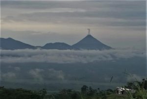
Colombia , Nevado del Ruiz :
Manizales, 09 May 2023 09:15
Regarding the monitoring of the activity of the NEVADO DEL RUIZ VOLCANO, the MINISTRY OF MINES AND ENERGY through the COLOMBIAN GEOLOGICAL SERVICE (SGC) informs that:
Yesterday May 8, and until today, the seismic activity related to the movement of fluids inside the volcanic conduits continues to predominate. This seismicity presented a slight increase in the number of earthquakes and the seismic energy released compared to May 7. Some of these signals have been linked to pulsating ash emissions, confirmed by web cameras used for volcanic monitoring. In addition, the seismicity record associated with the fracturing of the rock inside the volcanic edifice continues, which showed a similar behavior in number of earthquakes and seismic energy compared to May 7. The earthquakes were located in the Arenas crater and scattered around it, at a maximum distance of 5 km and at depths between 1 and 6 km.
Regarding surface activity, the maximum height of the column of gas and / or ash observed was 1000 m measured from the summit of the volcano and was linked to an emission of ash recorded on May 8 at 7:27 p.m. The preferred direction of dispersion of the gas column was towards the West – South-West and North-West of the volcano. From satellite monitoring platforms, several significant thermal anomalies were observed at the bottom of the crater. On the other hand, the variations in the degassing of sulfur dioxide and the release of water vapor from the crater into the atmosphere are maintained.
The level of activity of the volcano remains at the ORANGE LEVEL of activity or (II): PROBABLE ERUPTION IN TERM OF DAYS OR WEEKS.
Source et photo : Ingeominas
Iceland , Katla :
After the powerful earthquake on Friday, the state of uncertainty is now lifted.
The state of uncertainty due to the Mýrdalsjökull earthquake has been cancelled.
After a series of powerful earthquakes Friday morning in the Katla caldera, where three earthquakes were measured above magnitude four, there was little activity in the area.
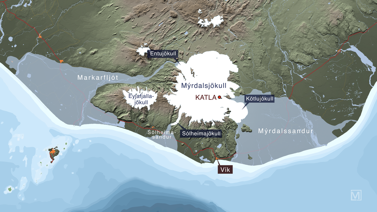
One of the quakes was the second-largest earthquake recorded since modern seismic monitoring began in 1991, but there is now no indication that there will be further news, a Civil Defense statement said. .
Scientists were quickly convinced that earthquakes had more to do with water and geothermal energy than the movement of magma. A yellow air alert was in place for a short time, but reverted to green on Saturday. Police in South Iceland closed the Katlujökull road on Friday, but it was also reopened on Saturday.
Source et photo : RUV Iceland.
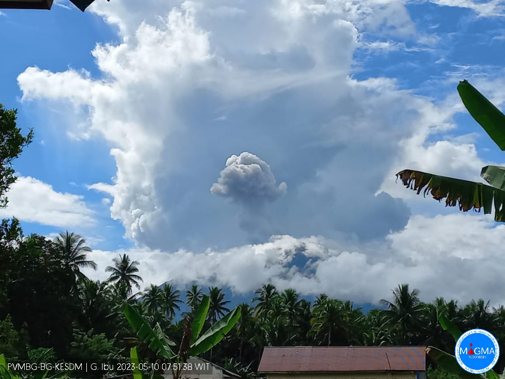
Indonesia , Ibu :
The Ibu volcano presented an eruption on Wednesday, May 10, 2023 at 09:40 WIT with the height of the ash column observed at ± 800 m above the summit (± 2125 m above sea level). The ash column was observed to be gray with a thick intensity, oriented northwest. This eruption was recorded on a seismograph with a maximum amplitude of 28 mm and a duration of 80 seconds.
VOLCANO OBSERVATORY NOTICE FOR AVIATION – VONA
Issued : May 10 , 2023
Volcano : Ibu (268030)
Current Aviation Colour Code : ORANGE
Previous Aviation Colour Code : orange
Source : Ibu Volcano Observatory
Notice Number : 2023IBU004
Volcano Location : N 01 deg 29 min 17 sec E 127 deg 37 min 48 sec
Area : North Maluku, Indonesia
Summit Elevation : 4240 FT (1325 M)
Volcanic Activity Summary :
Eruption with volcanic ash cloud at 00h40 UTC (09h40 local).
Volcanic Cloud Height :
Best estimate of ash-cloud top is around 6800 FT (2125 M) above sea level or 2560 FT (800 M) above summit. May be higher than what can be observed clearly. Source of height data: ground observer.
Other Volcanic Cloud Information :
Ash cloud moving to northwest. Volcanic ash is observed to be gray. The intensity of volcanic ash is observed to be thick.
Remarks :
Eruption recorded on seismogram with maximum amplitude 28 mm and maximum duration 80 second.
Source et photo : Magma Indonésie.
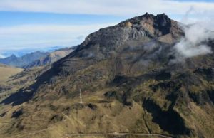
Hawaii , Kilauea :
Tuesday, May 9, 2023, 9:24 AM HST (Tuesday, May 9, 2023, 19:24 UTC)
19°25’16 » N 155°17’13 » W,
Summit Elevation 4091 ft (1247 m)
Current Volcano Alert Level: ADVISORY
Current Aviation Color Code: YELLOW
Activity Summary:
Kīlauea volcano is not erupting, and no active lava has been observed since March 7, 2023. Instruments in the summit region are tracking an increase in summit inflation at this time, while summit seismicity remains elevated. No significant changes have been observed along either of the volcano’s rift zones over the past day.
Halemaʻumaʻu Crater Observations:
No active lava has been observed over the past day.

This view of Halema‘uma‘u was captured from partway up the northwestern wall of the crater by an HVO geologist visiting the area on Wednesday, May 3, to collect geologic samples. The basin of the lava lake from the end of the most recent eruption is defined by the steaming area in the upper center of the frame.
Summit Observations:
Instruments in the summit region have tracked a sharp increase in tilt that began at 6 a.m. and continues at this time. The increased inflation rate contrasts with the relatively flat pattern seen over the past 3 days. Overall, inflation at the summit of Kīlauea is higher than conditions preceding the January 5, 2023 summit eruption and it continues to increase, Small flurries of earthquakes continue irregularly beneath Halemaʻumaʻu, Keanakākoʻi Crater, and the southern margin of Kaluapele (Kīlauea caldera) since April 16. Rates of summit earthquakes remain elevated, and additional earthquake flurries are possible. The most recent sulfur dioxide (SO2) emission rate of approximately 135 tonnes per day was measured on May 3.
Rift Zone Observations:
No unusual activity has been noted along the East Rift Zone or Southwest Rift Zone; steady rates of ground deformation and seismicity continue along both. Measurements from continuous gas monitoring stations in the middle East Rift Zone—the site of 1983–2018 eruptive activity—remain below detection limits for SO2.
Source : HVO
Photo : USGS/ M. Zoeller.