Mai 6, 2023.
Guatemala , Fuego :
Information Bulletin No. 046-2023
According to information published by the Special Volcanological Bulletin BEFGO #025-2023 of INSIVUMEH, the eruptive activity of the Fuego volcano is decreasing.
It should be mentioned that the volcanic complex maintains explosive activity, this generates columns of gas and ash with heights of up to 4,600 meters above sea level and disperses to the West at distances of 5 kilometers, said activity continues to generate the descent of avalanches of moderate to strong characteristics.
The presence of ash in the ravines of Ceniza, Seca and Las Lajas is still abundant and suspended in the environment, covering the vegetation, crops, roofs and patios of houses, as well as the streets and roads of these areas with accumulations up to 2 millimeters thick.
CONRED recalls the importance of safeguarding lives by putting into practice the principle of SELF-EVACUATION and by getting involved in preventive actions on their territories.
Finally, from the camera located in the crater of the Agua volcano at a distance of 15.5 kilometers from the Fuego volcano, you can see the live broadcast of the CRELOSA Fuego GT volcano: https://www.youtube.com/watch?v = M23Jl4-FTd0
Shortly after noon this Thursday, May 4, a process of evacuation of villagers from the surrounding communities of the Fuego volcano began. This is a preventive action against the present eruption, which leads to the descent of pyroclastic flows and explosions with falling ash.
They are residents of different communities, including Panimaché 1 and 2 of San Pedro Yepocapa, in the department of Chimaltenango.
Among the areas checked are the village El Rodeo, the communities La Reina and Osuna and the bridges La Fe 1 and 2, Las Lajas and Barranca Onda.
It was explained that they were transferred aboard a microbus to the gymnasium of Santa Lucia Cotzumalguapa, which is activated as a temporary shelter. Those cared for are 18 children, 18 women and two men.
Source : Conred. Insivumeh.
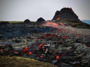
Photo : Guias Leonel Acatenango
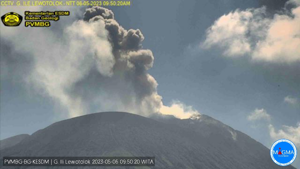
Indonesia , Ili Lewotolok :
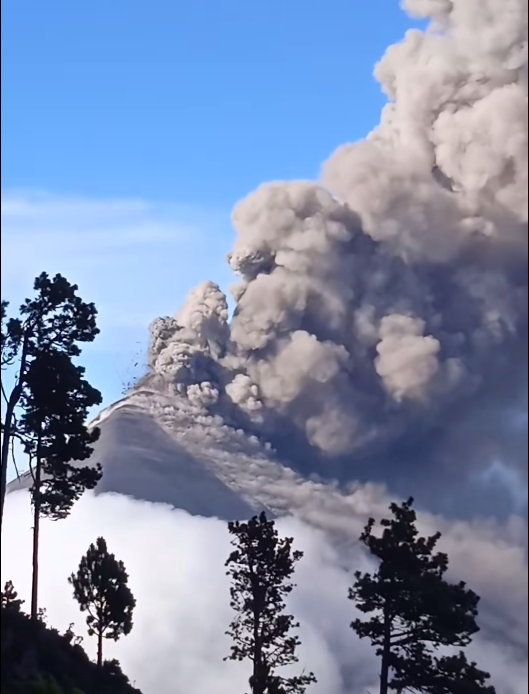
An eruption of G. Ili Lewotolok occurred on Saturday May 06, 2023 at 09:48 WITA with the height of the ash column observed at ± 700 m above the summit (± 2123 m above sea level) . The ash column was white, gray to black with a thick intensity, oriented southwest and west. This eruption was recorded on a seismograph with a maximum amplitude of 23.4 mm and a duration of 65 seconds.
VOLCANO OBSERVATORY NOTICE FOR AVIATION – VONA
Issued : May 06 , 2023
Volcano : Ili Lewotolok (264230)
Current Aviation Colour Code : ORANGE
Previous Aviation Colour Code : orange
Source : Ili Lewotolok Volcano Observatory
Notice Number : 2023LEW021
Volcano Location : S 08 deg 16 min 19 sec E 123 deg 30 min 18 sec
Area : East Nusa Tenggara, Indonesia
Summit Elevation : 4554 FT (1423 M)
Volcanic Activity Summary :
Eruption with volcanic ash cloud at 01h48 UTC (09h48 local).
Volcanic Cloud Height :
Best estimate of ash-cloud top is around 6794 FT (2123 M) above sea level or 2240 FT (700 M) above summit. May be higher than what can be observed clearly. Source of height data: ground observer.
Other Volcanic Cloud Information :
Ash cloud moving from southwest to west. Volcanic ash is observed to be white to dark. The intensity of volcanic ash is observed to be thick.
Remarks :
Eruption recorded on seismogram with maximum amplitude 23.4 mm and maximum duration 65 second.
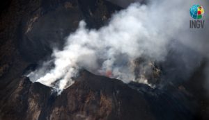
Source et photo : Magma Indonésie
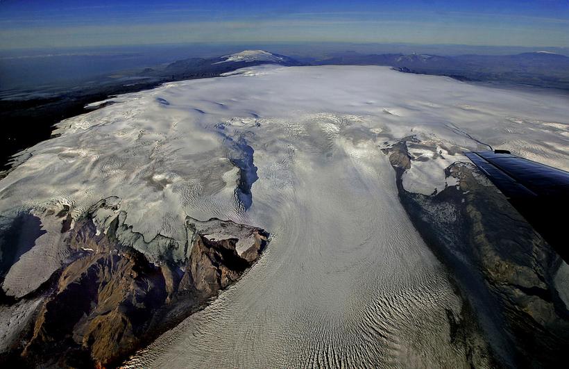
Iceland , Katla :
Katla was calm tonight. Yesterday, the Civil Protection Department declared a heightened alert in the area, which is still in effect.
A heightened alert was declared yesterday following powerful earthquakes in the Mýrdalsjökull glacier region.
For the first time in seven years, a state of heightened alert was incurred due to seismic activity in Katla. No eruption or glacial flooding has occurred, but developments are closely monitored.
Tour companies have decided to cancel trips to the glacier until the situation stabilizes.
A notice from the Department of Civil Protection of the State Police (Almannavarnir ríkislögreglustjóra) said that staying at the foot of Katla is not advisable due to the possible release of gases and glacial water runoff down the Múlakvísl River.
« We cannot predict how the situation will develop, and we can only wait and take measurements, » reads the Department of Civil Protection statement.
Four strong earthquakes, with a magnitude of more than four on the Richter scale, occurred yesterday morning in the northeastern part of the Katla volcano’s caldera. Following the tremors, it was decided to raise the air danger level over the volcano to yellow.
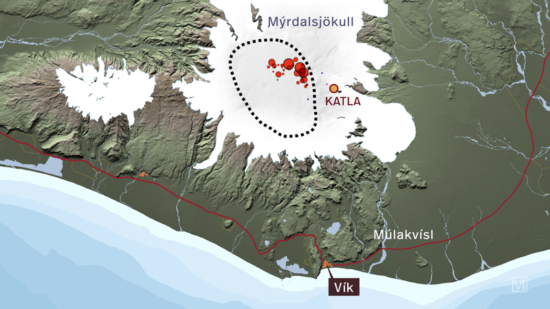
The earthquakes are marked with red dots on the map above, and the black circle marks Katla’s caldera. The quakes occurred in the northeastern caldera and had magnitudes of 4.8, 4.4, 4.3 and 4.2. They were felt by residents of Vík, as well as those travelling in the Þórsmörk area.
Source : RUV.
Photo : IMO.
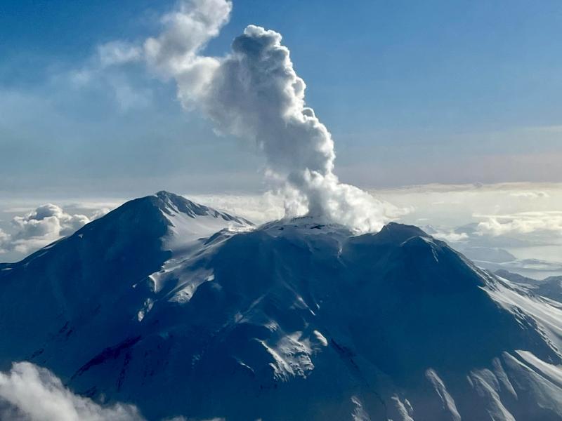
Alaska , Great Sitkin :
52°4’35 » N 176°6’39 » W,
Summit Elevation 5709 ft (1740 m)
Current Volcano Alert Level: WATCH
Current Aviation Color Code: ORANGE
Lava continued to slowly erupt at Great Sitkin over the past week, adding to a thick lava flow confined to the summit crater. Satellite images through May 5 showed that the lava flow is growing mainly to the east into the summit crater ice field. Only a few small local earthquakes were detected at Great Sitkin during the week. No other noteworthy activity was observed in cloud-obscured views of the volcano in satellite and web camera data.
Great Sitkin is monitored by local seismic and infrasound sensors, satellite data, web cameras, and regional infrasound and lightning networks.
Great Sitkin Volcano is a basaltic andesite volcano that occupies most of the northern half of Great Sitkin Island, a member of the Andreanof Islands group in the central Aleutian Islands. It is located 26 miles (43 km) east of the community of Adak. The volcano is a composite structure consisting of an older dissected volcano and a younger parasitic cone with a ~1 mile (1.5 km)-diameter summit crater. A steep-sided lava dome, emplaced during the 1974 eruption, occupies the center of the crater. That eruption produced at least one ash cloud that likely exceeded an altitude of 25,000 ft (7.6 km) above sea level. A poorly documented eruption occurred in 1945, also producing a lava dome that was partially destroyed in the 1974 eruption. Within the past 280 years a large explosive eruption produced pyroclastic flows that partially filled the Glacier Creek valley on the southwest flank.
Source : AVO.
Photo : Skeehan, Steven
Colombia , Nevado del Ruiz :
Manizales, May 5, 2023 10:30 a.m.
Regarding the monitoring of the activity of the NEVADO DEL RUIZ VOLCANO, the MINISTRY OF MINES AND ENERGY through the COLOMBIAN GEOLOGICAL SERVICE (SGC) informs that:
Yesterday May 4, the seismic activity associated with the fracturing of the rock inside the volcanic edifice increased in the number of earthquakes recorded and in seismic energy released, compared to the previous day (May 3). The seismicity was located mainly in the East-North-East sector of the volcano, at distances between 2 and 5 km from the Arenas crater and in the crater itself and, to a lesser extent, there were earthquakes in the Southeast area. The depth of all recorded earthquakes ranged from 1 to 5 km. The earthquake recorded yesterday at 3:14 p.m., of magnitude 2.2 and located about 4 km east-northeast of the crater, stands out, which was reported as felt in the sector of La Cabaña, municipality of Casabianca (Tolima).

Seismic activity related to the movement of fluids inside volcanic conduits continues to predominate on the volcano. Yesterday May 4 and until today, this seismicity showed a similar behavior in terms of the number of earthquakes and released seismic energy compared to the day before (May 3). Some of the seismic signals associated with this type of seismicity have been linked to pulsating ash emissions confirmed by web cameras used for volcanic monitoring.
With regard to the outgassing of sulfur dioxide in the atmosphere and the release of water vapor from the crater, this continues to show variations. The maximum height of the column of gas and / or ash observed yesterday was 1400 m (in dispersion) measured from the summit of the volcano. Regarding the direction of dispersion of the column, it had a preferential direction towards the northwest sector of the volcano. Yesterday there were ash falls in the municipalities of Neira and Manizales (Caldas) and during this morning we received reports of ash falls in the municipalities of Villamaría and Manizales. Thermal anomalies continue to be observed at the bottom of the crater, and yesterday there were several reports from satellite monitoring platforms.
The level of activity of the volcano remains at the ORANGE LEVEL of activity or (II): PROBABLE ERUPTION IN TERM OF DAYS OR WEEKS
Source et photo : SGC.