May 01 , 2023.
Alaska , Trident :
58°14’3″ N 155°6’9″ W,
Summit Elevation 3599 ft (1097 m)
Current Volcano Alert Level: ADVISORY
Current Aviation Color Code: YELLOW
Earthquake activity continued in the vicinity of Trident Volcano over the last 24 hours at a rate above background levels. No volcanic activity was observed in cloudy to partly cloudy satellite and web camera data.
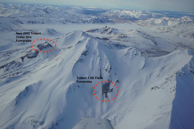
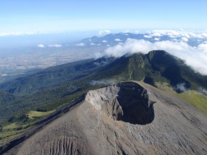
Aerial view of Trident volcano with persistent degassing features on the crater rim of Southwest (New) Trident and the southeast flank of Trident I circled in red.
The current period of seismic unrest began on August 24, 2022. Increases in seismic activity have been detected previously at Trident Volcano and other similar volcanoes, with no subsequent eruptions. We expect additional shallow seismicity and other signs of unrest, such as gas emissions, elevated surface temperatures, and surface deformation, to precede any future eruption if one were to occur.
AVO monitors Trident Volcano with a local network of seismometers, a webcam, remote sensing data, and regional infrasound and lightning networks.
Source : AVO
Photo : Lopez, Taryn .
Mexico , Popocatepetl :
April 30, 11:00 a.m. (April 30, 5:00 p.m. GMT)
In the past 24 hours, according to the monitoring systems of the Popocatépetl volcano, 65 exhalations accompanied by water vapor, volcanic gases and ash have been detected, as well as 103 minutes of high frequency and low amplitude tremors.
Similarly, a small explosion was recorded yesterday at 11:50 p.m. local time.
Explosions that occur on Popocatépetl or any active volcano are accompanied by seismic and sound signals, the latter recorded by means of pressure detectors or microphones. It is possible to hear them with different levels of intensity, depending on the atmospheric factors at the time of the events or the morphological conditions of the crater. This is a normal phenomenon and is not necessarily an indication of increased volcanic activity. It should be noted that in the current state of Popocatépetl, characterized by the formation of small lava domes, and their subsequent destruction by explosions, mainly of small to moderate size, it is likely that in the next days or weeks the population near the volcano will perceive these audible phases.
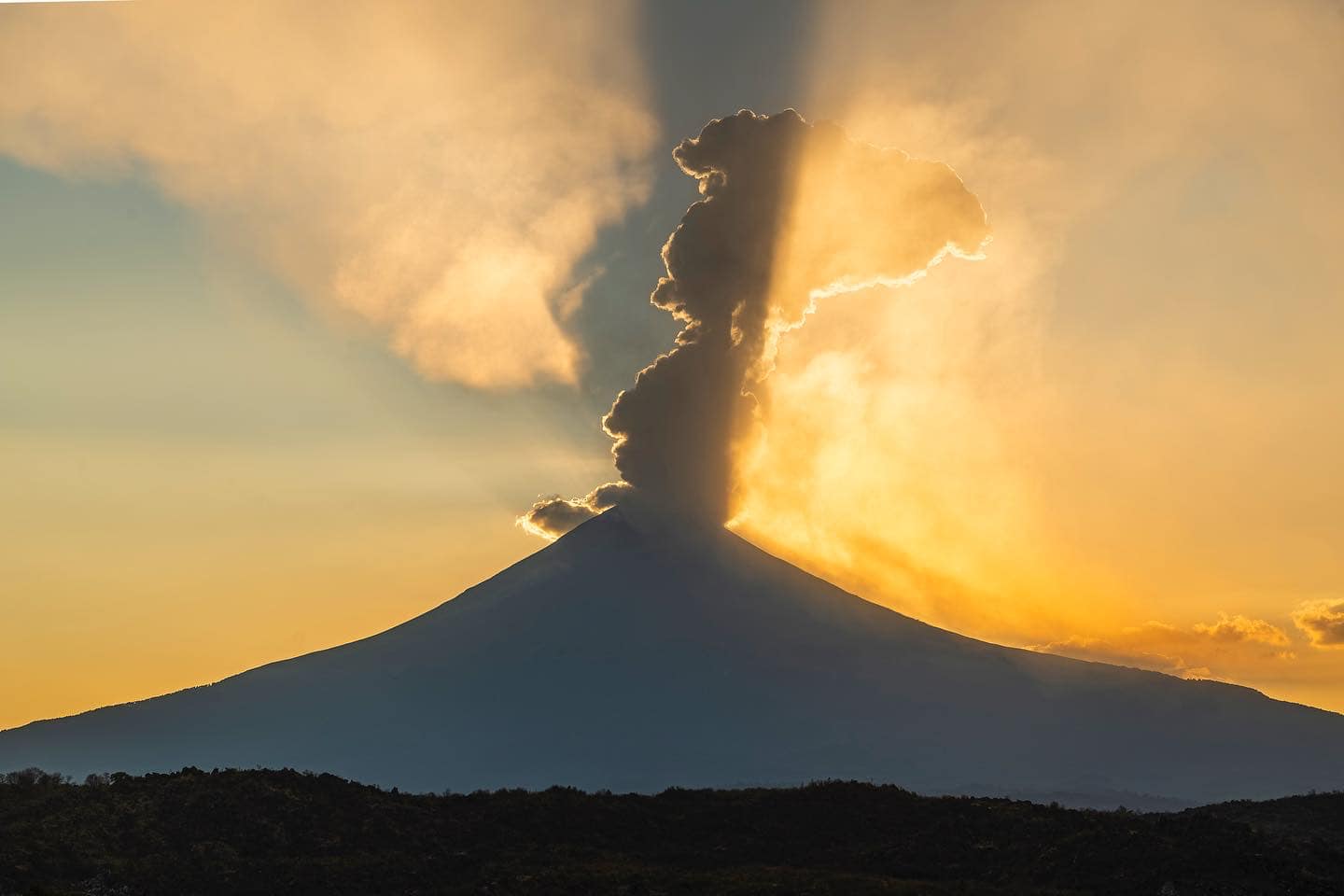
During the morning, and at the time of this report, an emission of volcanic gases and ash was observed in an East-Northeast direction.
CENAPRED insistently reiterates the recommendation NOT TO CLIMB to the crater of the volcano, because there is the possibility of explosions, as we have seen on several occasions in the past, involving the emission of incandescent fragments. Therefore, he is required to respect the exclusion radius of 12 km. Also, in heavy rain, stay away from the bottom of ravines due to the danger of mudslides and debris.
The Popocatépetl volcanic alert traffic light is in YELLOW PHASE 2.
Source : Cenapred.
Photo : Erik Gomez Tochimani Photographe
Indonesia , Semeru :
VOLCANO OBSERVATION NOTICE FOR AVIATION – VONA
Issued: April 30, 2023
Volcano: Semeru (263300)
Current Aviation Color Code: ORANGE
Previous Aviation Color Code: orange
Source: Semeru Volcano Observatory
Notification number: 2023SMR163
Volcano location: S 08 deg 06 min 29 sec E 112 deg 55 min 12 sec
Region: East Java, Indonesia
Summit elevation: 11763 FT (3676 M)
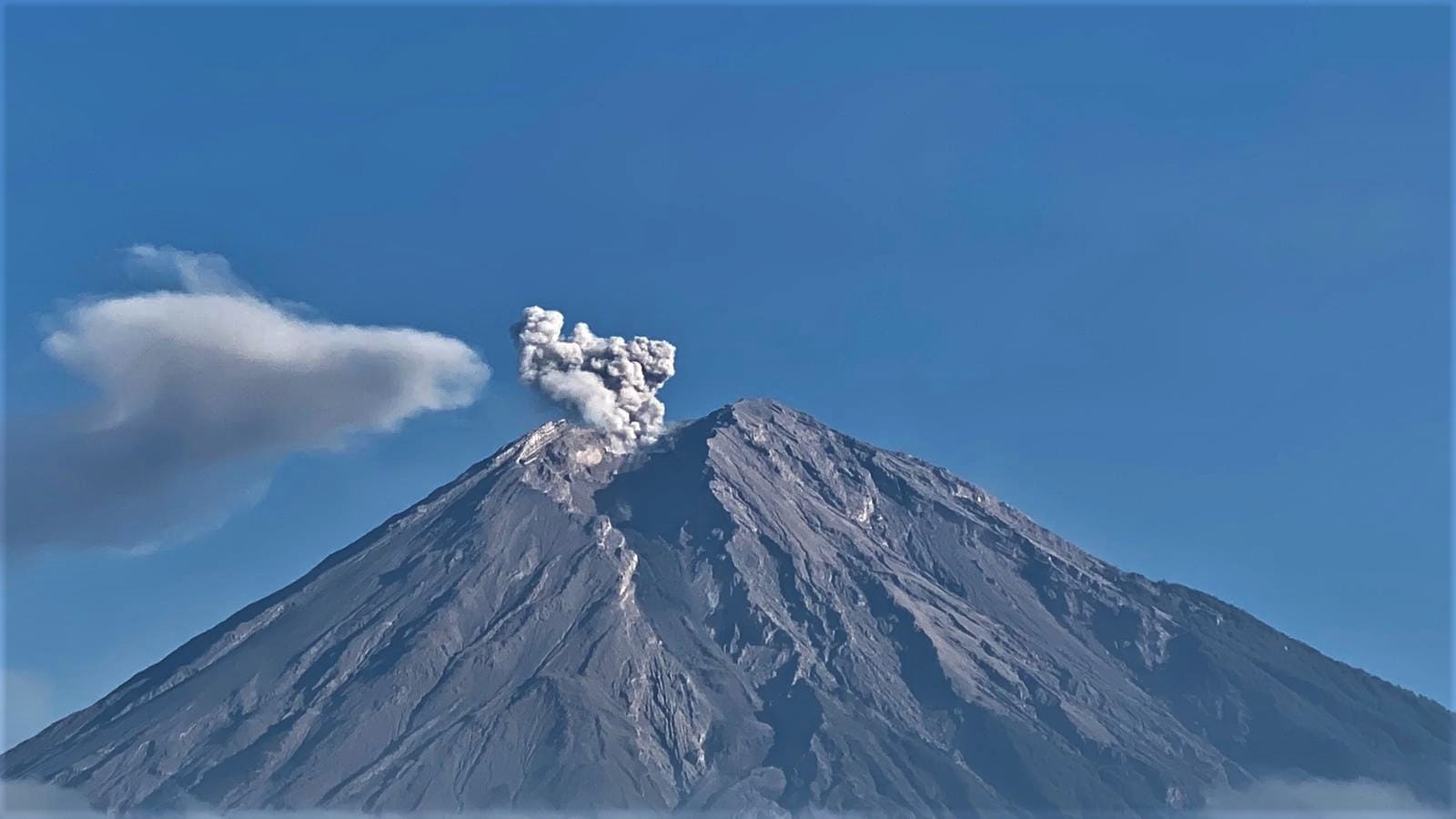
Volcanic Activity Summary :
Eruption with volcanic ash cloud at 23h11 UTC (06h11 local).
Volcanic Cloud Height :
Best estimate of ash-cloud top is around 14003 FT (4376 M) above sea level or 2240 FT (700 M) above summit. May be higher than what can be observed clearly. Source of height data: ground observer.
Other Volcanic Cloud Information :
Ash cloud moving from south to southwest. Volcanic ash is observed to be white to gray. The intensity of volcanic ash is observed to be thick.
Remarks :
Eruption recorded on seismogram with maximum amplitude 20 mm and maximum duration 110 second.
Source : Magma Indonésie.
Photo : Andi Volcanist.
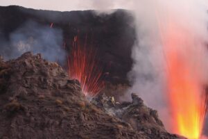
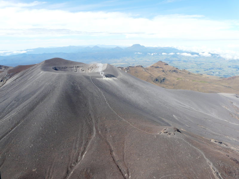
Colombia , Purace – Los Coconucos Volcanic Range:
Puracé Volcano Weekly Activity Bulletin – Los Coconucos Volcanic Range
From the monitoring of the activity of the PURACÉ VOLCANO – VOLCANIC CHAIN OF LOS COCONUCOS, the MINISTRY OF MINES AND ENERGY through the COLOMBIAN GEOLOGICAL SERVICE (SGC) reports:
During the week of April 18-24, 2023, seismic activity showed stable behavior, with a total of 976 earthquakes, of which 114 were associated with rock fracturing processes and 862 with fluid dynamics in volcanic conduits. This process was accompanied by a deformation of the soil of the volcanic edifice associated with a process of inflation. Degassing of the volcanic system was highlighted, with a white column preferentially oriented towards the northwest, with a maximum sulfur dioxide (SO2) flow rate of 661 t/d and a maximum concentration of 20437 ppm for sulfur dioxide. carbon (CO2) in the area of the crater of the Puracé volcano as well as a significant increase in the degassing of carbon dioxide (CO2) in the San Juan region. These values are important in the degassing process of this volcanic system relative to its baseline.
The other parameters measured and used for the diagnosis of volcanic activity did not show significant changes during the period evaluated.
Volcanic activity continues to record variations which could evolve towards higher levels of activity.
The activity level of the volcano remains at:
YELLOW LEVEL (III): CHANGES IN THE BEHAVIOR OF VOLCANIC ACTIVITY.
Source et photo : SGC
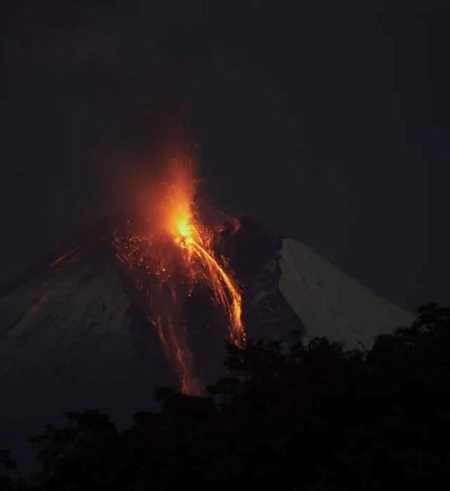
Ecuador , Sangay :
DAILY REPORT OF THE STATE OF SANGAY VOLCANO, Sunday April 30, 2023.
Information Geophysical Institute – EPN.
Surface Activity Level: High, Surface Trend: Unchanged
Internal activity level: High, Internal trend: No change
Seismicity: From April 29, 2023, 11:00 a.m. to April 30, 2023, 11:00 a.m.:
The reference station has data transmission problems, which is why the count of seismic events for this day is not presented
.
Rains / Lahars:
Rain events were recorded in the area which did not generate signals associated with mudslides and debris. **In case of heavy rains, secondary lahars can be generated in the Volcán, Upano rivers and other tributaries**
Emission / Ash Column:
Due to the cloudiness of the area, there are no observations of surface activity in the area, however, the Washington VAAC recorded 2 alerts for satellite-observed ash emissions, which reached heights of 1100 meters above crater level in a westerly direction.
Other Monitoring Parameters:
The FIRMS system records 1 thermal alert while MIROVA-MODIS records 1 moderate thermal alert and MIROVA-VIIRS records 1 high thermal alert (219 MW) in the last 24 hours.
Gas:
The MOUNTS system recorded 260.1 tons of sulfur dioxide (SO2), measured on 2023-02-04 at 2:29 p.m. TL.
Observation:
Cloudiness was permanent in the area, preventing direct observation of surface activity.
Alert level: Orange.
Source : IGEPN.
Photo : Diego Cardenas.
Hawaii , Kilauea :
19°25’16 » N 155°17’13 » W,
Summit Elevation 4091 ft (1247 m)
Current Volcano Alert Level: ADVISORY
Current Aviation Color Code: YELLOW
Activity Summary:
Kīlauea volcano is not erupting, and no active lava has been observed since March 7, 2023. Inflationary tilt in the summit region slowed yesterday afternoon and instruments have tracked deflationary tilt so far today. Summit seismicity remains elevated. No significant changes have been observed along either of the volcano’s rift zones over the past day.
Halemaʻumaʻu Crater Observations:
No active lava has been observed over the past day.
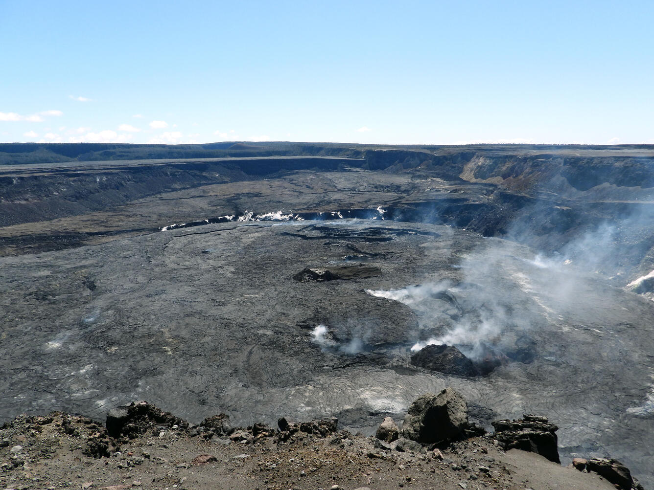
During a morning visit to Halema‘uma‘u rim on April 14, Hawaiian Volcano Observatory geologists had clear views across Kīlauea summit caldera. Kīlauea stopped erupting on March 7; currently, only steam and minor gas emissions are being emitted at the summit.
Summit Observations:
Two HVO tiltmeters—at Uēkahuna and southwest of the summit at Sand Hill—were tracking accelerated inflationary tilt yesterday morning, but this slowed in the afternoon. The instruments have tracked minor deflationary tilt so far today. Small flurries of earthquakes have occurred irregularly beneath Halemaʻumaʻu, Keanakākoʻi Crater, and the southern margin of Kaluapele (Kīlauea caldera) since April 16, including a significant uptick early yesterday morning. This continued through the period of sharper inflationary tilt before diminishing slightly yesterday afternoon. Rates of summit earthquakes remain elevated, and continued earthquake flurries are possible. The most recent sulfur dioxide (SO2) emission rate of approximately 75 tonnes per day was measured on April 26.
Source : HVO.
Photo : USGS / K. Mulliken.