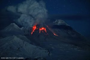
November 3 , 2020.
Indonesia , Sinabung :
VOLCANO OBSERVATORY NOTICE FOR AVIATION – VONA.
Issued : November 30 , 2020
Volcano : Sinabung (261080)
Current Aviation Colour Code : ORANGE
Previous Aviation Colour Code : orange
Source : Sinabung Volcano Observatory
Notice Number : 2020SIN34
Volcano Location : N 03 deg 10 min 12 sec E 98 deg 23 min 31 sec
Area : North Sumatra, Indonesia
Summit Elevation : 7872 FT (2460 M)
Volcanic Activity Summary :
Eruption with volcanic ash cloud at 04h34 UTC (11h34 local)
Volcanic Cloud Height :
Ash-cloud is not visible
Other Volcanic Cloud Information :
volcano cloudy
Remarks :
Seismic activity is characterized by eruption volcanic event
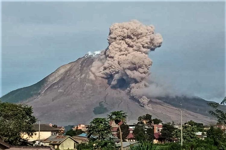
The activity level has been at level III (SIAGA) since May 20, 2019 at 10:00 a.m. The Sinabung volcano (2460 m altitude) has been erupting since 2013.
The volcano was clearly visible until it was covered in fog. The crater emits faint to thick white smoke, with a height of about 50-500 meters above the summit. The weather is sunny to cloudy, with light to moderate winds to the North, East and West. The air temperature is around 15.8-26 ° C.
According to the seismographs of November 29, 2020, it was recorded:
1 eruption / explosion earthquake
77 avalanche earthquakes
1 Harmonic earthquake
21 low frequency earthquakes
17 hybrid / multi-phase earthquakes
5 distant tectonic earthquakes
Source : Magma Indonésie , PVMBG.
Photo : Peneliti Priatna PVMBG ( archive) .
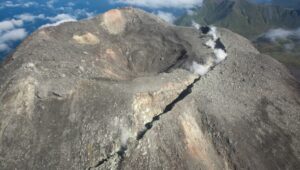
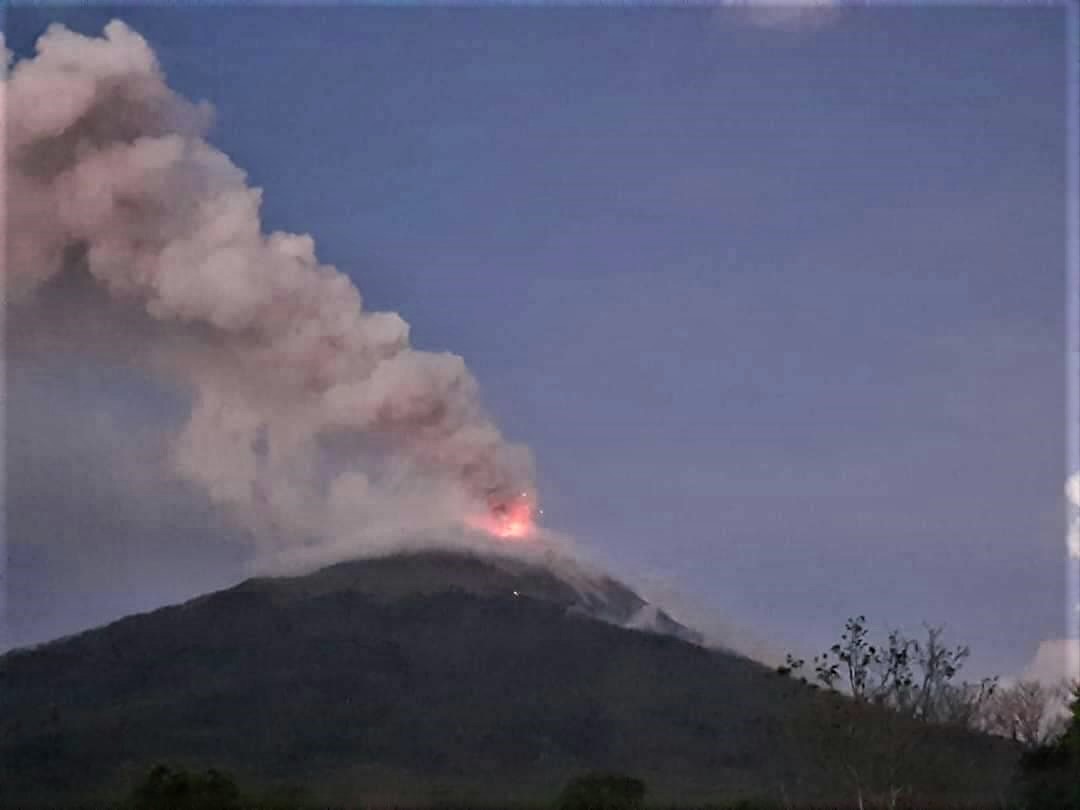
Indonesia , Ili Lewotolok :
Level of activity at level II (SIAGA) since October 7, 2017 at 8:00 p.m. The increased status of this level of activity has been driven by a significant increase in seismicity, particularly local tectonic (TL), deep volcanic (VA) and shallow volcanic (VB) earthquakes since mid- September 2017.
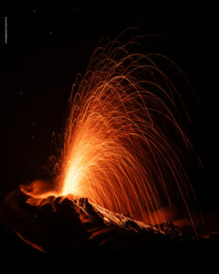
Ili Lewotolok volcano (1018 m above sea level) erupted on November 27, 2020 at 05:57, with an ash column height that was observed to be gray / black in color 500 m above the summit ( ± 1923 m above sea level) with high intensity, oriented in a West direction. This eruption was recorded on a seismogram with a maximum amplitude of 34 mm and the duration of the eruption was not clearly observed because it was followed by continuous tremors. On November 29, 2020 at 1:00 p.m., the activity level of the Ili Lewotolok volcano went from level II (WASPADA) to level III (SIAGA).
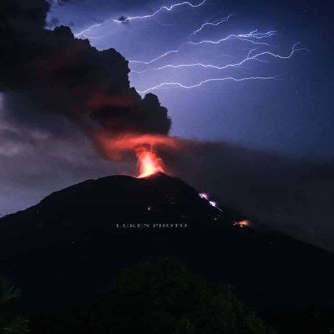
The results of the last day of monitoring showed that the volcano was clearly visible until it was covered in fog. It was observed that the crater emitted gray smoke with high intensity about 200-4000 meters above the summit. 7 eruptions were observed with heights of ash columns of 1400 to 4000 meters above the peak, accompanied by emissions of incandescent material above the peak. At night, there is glow in the summit area. There were thumping and rumbling noises and a strong smell of sulfur from the PGA station at Ili Lewotolok. The weather is sunny with light to moderate winds to the east and west. Air temperature: 25.3-28.1 ° C.
According to the seismographs of November 29, 2020, it was recorded:
7 eruption / explosion earthquakes
9 harmonic tremors
6 non-harmonic tremors
2 shallow volcanic earthquakes
9 deep volcanic earthquakes
Continuous tremor of amplitude from 2 to 25 mm (dominant value 7 mm).
on November 30, 2020 at 6 a.m., it was recorded:
7 eruption / explosion earthquakes
25 deep volcanic earthquakes
Continuous tremor with an amplitude of 3 to 13 mm (dominant value 6 mm).
Recommendation:
-Communities around Ili Lewotolok and visitors / climbers / tourists are recommended not to conduct activities within a radius of 4 km around the summit crater.
– Considering the potential danger of volcanic ash which can cause acute respiratory problems (ISPA) and other health issues, people around Ili Lewotolok should prepare nasal and mouth masks and other equipment to protect their eyes and their skin.
Source : Magma Indonésie , PVMBG.
Photos : Luken photo via Sherine France , Rizal M.
Video : Carlos Juan Semidey
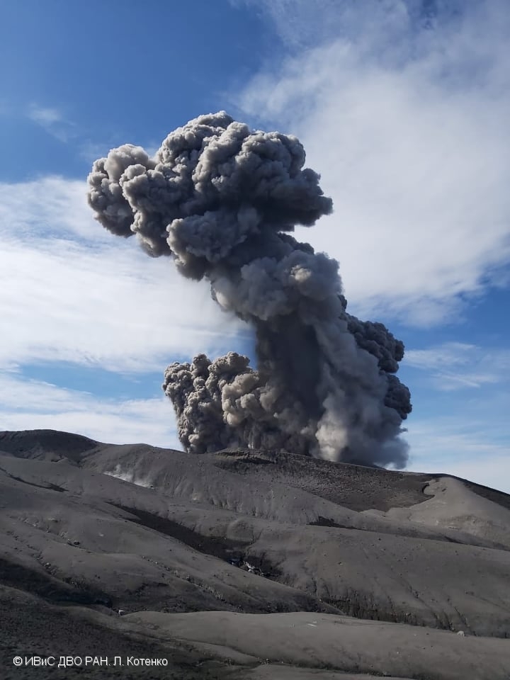
Russia / Kurile Islands , Ebeko :
VOLCANO OBSERVATORY NOTICE FOR AVIATION (VONA).
Issued: November 29 , 2020
Volcano: Ebeko (CAVW #290380)
Current aviation colour code: ORANGE
Previous aviation colour code: orange
Source: KVERT
Notice Number: 2020-224
Volcano Location: N 50 deg 41 min E 156 deg 0 min
Area: Northern Kuriles, Russia
Summit Elevation: 3791.68 ft (1156 m)
Volcanic Activity Summary:
A moderate eruptive activity of the volcano continues. According to visual data by volcanologists from Severo-Kurilsk, explosion sent ash up to 3.0 km a.s.l., an ash cloud is drifting to the east of the volcano.
This eruptive activity continues. Ash explosions up to 19,700 ft (6 km) a.s.l. could occur at any time. Ongoing activity could affect low-flying aircraft and airport of Severo-Kurilsk.
Volcanic cloud height:
8200-9840 ft (2500-3000 m) AMSL Time and method of ash plume/cloud height determination: 20201129/2208Z – Visual data
Other volcanic cloud information:
Distance of ash plume/cloud of the volcano: 3 mi (5 km)
Direction of drift of ash plume/cloud of the volcano: E
Time and method of ash plume/cloud determination: 20201129/2208Z – Visual data
Source : Kvert .
Photo : L. Kotenko. IVS FEB RAS (archive Kvert) .
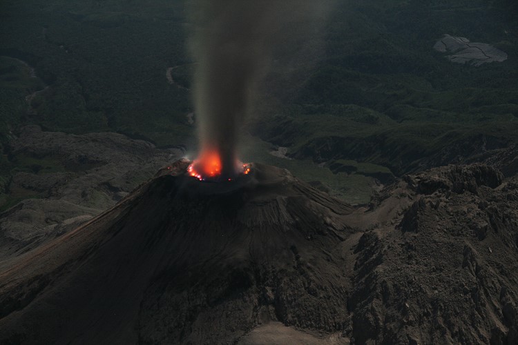
Guatemala , Santiaguito :
Activity type: Pelean
Morphology: Complex of dacitic domes
Geographical location: 14 ° 44 ’33 ˝ Latitude N; 91 ° 34’13˝ Longitude W.
Height: 2500 m.
Weather conditions: Partly cloudy
Wind: south-east
Precipitation: 16.0 mm.
Activity:
A degassing is observed, during certain prolonged moments, of white and gray color which disperses to the West and South-West, and reaches heights of 100 to 500 meters above the Caliente dome. Seismic recording makes it possible to observe weak to moderate explosions. These generate plumes of gas and ash, with altitudes of up to 3,200 meters (10,498 feet). Weak to moderate boulder and ash avalanches are also recorded mainly towards the southwest flank, but they can be generated towards the south, southeast and west flanks. The paths of these materials reach the base of the dome and drop fine particles of ash on the volcanic perimeter. Due to the location of the block lava flows in the dome of the Caliente dome, in a West-South-West direction, the appearance of boulder avalanches and ash flows in this same direction, as well as pyroclastic over long distances, are not excluded. For short periods, it is possible to hear sounds similar to those of an airplane turbine, due to the prolonged degassing of the Caliente dome. The recommendations of the special BESAN bulletin n ° 118-2020 remain in force.
Source : Insivumeh .
Photo : Marc Szeglat , 2009 , wikimedia