November 09 , 2020.
Indonesia , Merapi :
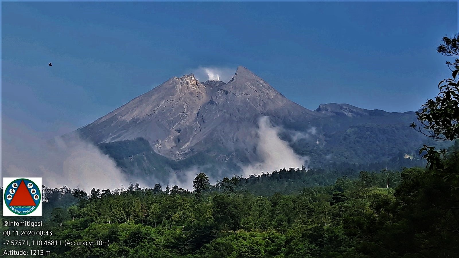
Following the increase in the activity status of Mount Merapi to SIAGA level (level III), no less than 133 residents of Sleman Regency, special region of Yogyakarta, were evacuated to a safe place on Saturday (7/11/2020) . Those who were evacuated are residents belonging to the category of vulnerable groups, for example the elderly, children and people with disabilities.
The residents who were evacuated were from the hamlet of Kalitengah Lor, village of Glagaharjo, district of Cangkringan, Sleman. Kalitengah Lor Hamlet is one of the hamlets which is in the danger zone of the eruption of Merapi.
The evacuation of residents began around 3:30 p.m. on Saturday. From Dusun Kalitengah Lor, residents have been transported using various types of vehicles, for example trucks, vans and motorcycles. They were then taken to a refugee camp in the assembly hall of the Glagaharjo village hall complex.
Sleman Regional Disaster Management Agency (BPBD) Director General Joko Supriyanto said 133 people had been evacuated. They are made up of 95 elderly people (seniors), 30 children, 3 pregnant women and 5 disabled people.
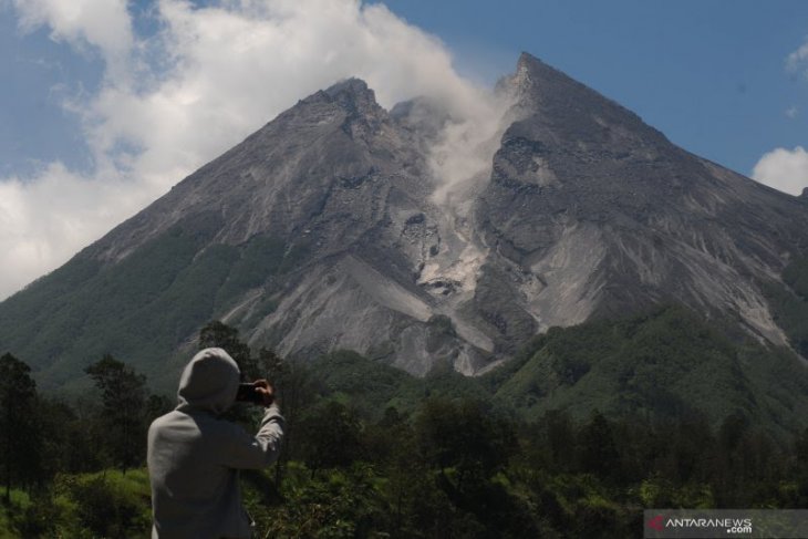
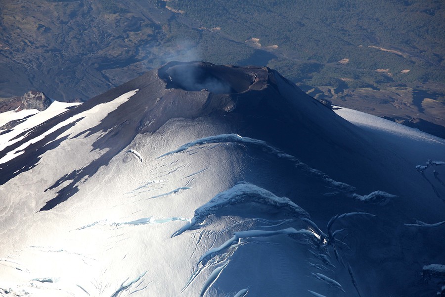
Level of activity at level III (SIAGA) since November 5, 2020 at 12:00 WIB. The Merapi volcano (2968 m above sea level) is continuously erupting. The last eruption took place on June 21, 2020 with the height of the eruption column at 6000 m above the summit. It was observed that the color of the ash column was gray.
The volcano was clearly visible until it was covered in fog. The crater emits white smoke, thin – thick, 20 to 150 m high above the summit. The weather is sunny to cloudy, with light to strong winds to the east, west and southwest. The air temperature is around 14-28 ° C. Avalanches have been observed with a sliding distance of 750 to 3000 m towards the West – North-West
According to the seismographs of November 8, 2020, it was recorded:
71 avalanche earthquakes
88 emission earthquakes
351 hybrid / multiphase earthquakes
31 shallow volcanic earthquakes
2 low frequency earthquakes
1 distant tectonic earthquake.
recommandations:
1. The risk zones forecasts include:
A. Province DIY
-Régence. Sleman. District. Cangkringan: village de Glagaharjo (hameau de Kalitengah Lor); Village de Kepuharjo (hameau de Kaliadem); Village d’Umbulharjo (hameau de Palemsari).
B. Central Province of Java
-Régence. Magelang. District de Dukun: village de Ngargomulyo (Dusun Batur Ngisor, Gemer, Ngandong, Karanganyar); Village de Krinjing (Dusun Trayem, Pugeran, Trono); Village de Paten (Babadan 1, Babadan 2)
-Régence. Boyolali. District de Selo: village de Tlogolele (hameau de Stabelan, Takeran, Belang); Village de Klakah (Sumber, Bakalan, Bangunsari, hameau de Klakah Nduwur); Village de Jrakah (Distance Hamlet, Sepi)
-Régence. Klaten. District. Kemalang: village de Tegal Mulyo (Dusun Pajekan, Canguk, Sumur); Village de Sidorejo (hameau de Petung, Kembangan, Deles); Village de Balerante (Dusun Kontakrejo, Ngipiksari, Gondang).
2. It is recommended to stop mining operations in the floodplains that are born at Mount Merapi.
3. Tourist actors must not carry out tourist activities near Mr. Merapi, including climbing activities up to the summit of Mount Merapi.
4. The government of Sleman Regency, Magelang Regency, Boyolali Regency and Klaten Regency must prepare for everything related to catastrophe attenuation efforts due to the eruption of Mount Merapi which may survive at any moment.
Source : Kompas , PVMBG.
Photos : Antaranews , Infomitigasi.
Chile , Villarica :
2956 long-period (LP) seismic events have been classified, generally associated with fluid dynamics inside the volcanic building, with reduced displacement (DR) values of less than 49 cm2.
– In addition, 2 volcano-tectonic (VT) earthquakes were classified, associated with the fracturing of rigid material; the largest event had a local magnitude (ML) of 0.9 and was located 4.7 km east of the crater, with a depth of 4.5 km.
– The continuous tremor seismic signal, also linked to the dynamics of the fluids inside the volcano, presented minor variations, with an average DR value of 2.5 cm2. The spectral content of the seismic signal varied from 0.8 to 1.6 Hz. At the end of this period, the frequency range was extended to 8 Hz. These changes in the frequency content of the seismic activity could be related to partial obstructions and greater difficulty in gas exit.
– Thanks to the images provided by the surveillance cameras and when the weather conditions allowed it, it was possible to observe an intermittent nocturnal incandescence and the presence of a column of whitish gas. Explosive episodes with pyroclastic emission were detected, highlighting the events of October 15 and 22, with column heights of 880 and 780 m, respectively.
Recording of unwanted explosive activity continues with the addition of particulate matter detected both in the images and in the deposits on the slopes surrounding the crater. This activity has been the most characteristic of the last few months, when the heights of the gas columns were the highest recorded during this year. Other parameters evaluated from the data of the instrumental network were considered low for this volcano.

However, the aforementioned explosive activity and changes in the frequency content of the seismic signal would be related to a partial plugging of the duct caused by a lower gas content in the magma column, which induces a decrease in its temperature and favors the formation of a shell which acts as a partial plug. Once gas builds up under the hull, overpressures are generated which cause surface explosions. It is suggested that the system still has the capacity to spontaneously generate activity with ballistic emissions around the crater. Likewise, larger and untimely increases could be facilitated at current levels of volcanic activity. It is pointed out that the state of the open conduit and the behavior of the fluctuating lava lake located near the surface, can cause explosions that can affect the vicinity of the crater.
Therefore, the alert level is maintained at:
YELLOW TECHNICAL ALERT: Changes in the behavior of volcanic activity.
Observation: Given the fluctuating dynamics of the lava lake, the area near the crater with a radius of 500 m is considered as an impacted area.
Source : Sernageomin .
Photos : Sernageomin , Volcanologia en Chile .
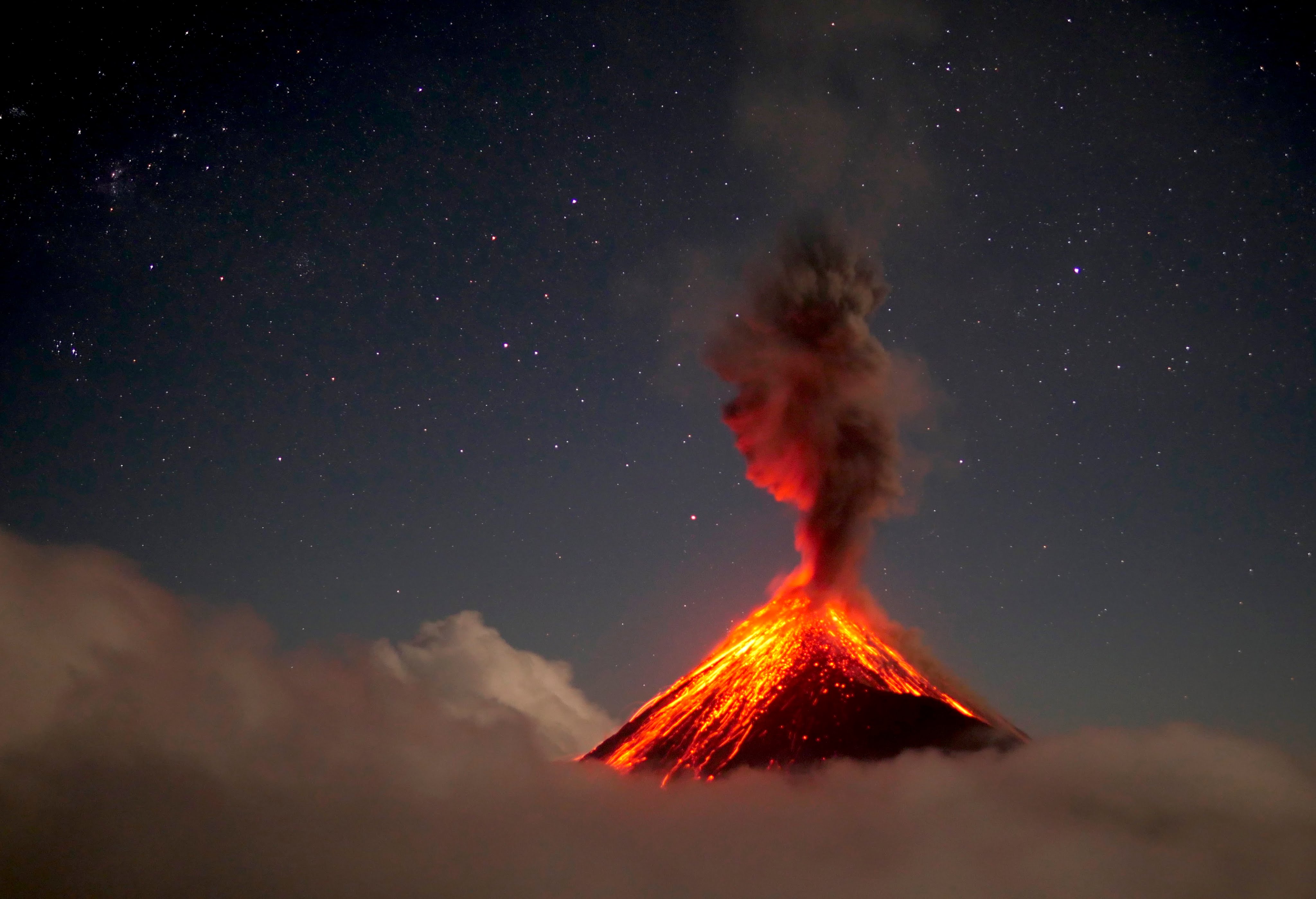
Guatemala , Fuego :
Activity type: Vulcanian
Morphology: composite stratovolcano
Geographical location: 14 ° 28’54˝ Latitude N; 90 ° 52’54˝ Longitude W
Height: 3763msnm
Atmospheric conditions: clear
Wind: north-west
Precipitation: 34.80 mm.
Activity:
The Fuego volcano observatory reports that incandescent pulses were observed at night and early in the morning. The explosions generated low, moderate and loud rumblings; with weak and moderate shock waves that vibrate the roofs and windows of neighboring towns. Low noises similar to that of a train locomotive were heard with intervals of 2 to 5 minutes. Weak to moderate explosions were maintained, in a range of 10 to 15 per hour, which are accompanied by columns of gray ash, reaching a height of between 4300 and 4700 (14,108 to 15,420 feet) which disperse in a South- East direction for a distance of about 12 to 15 kilometers, with the possibility of ash fall in San Juan Alotenango, Ciudad Vieja, San Miguel Dueñas and Antigua Guatemala. Avalanches are moderate to strong towards the Seca, Taniluyá, Ceniza, Lajas and Honda ravines with boulders reaching the vegetation.
Source : Insivumeh.
Photo : 660citynews.com.
Guadeloupe , La Soufrière :
Sequence of earthquakes in the La Soufrière area of Guadeloupe – Basse Terre
The sequence of volcanic earthquakes that began in the area of the La Soufrière volcano on Friday, November 6, 2020 at 1:30 a.m. local time (November 6, 2020 5:30 a.m. UT *) ended on Sunday, November 8, 2020 at 10:30 p.m. (universal time). *, TU). During this sequence 117 earthquakes were recorded.
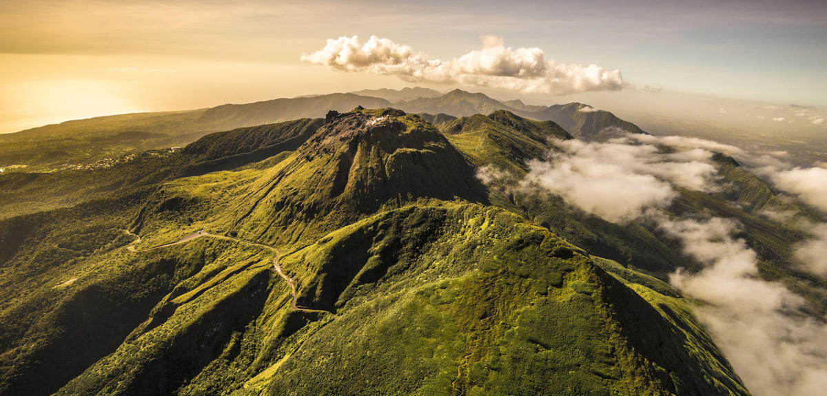
Earthquakes are of very low magnitude (M <1). No earthquakes were reported felt. The events are located at a depth of <2.5 km below the top of the dome of La Soufrière.
The alert level remains: yellow, vigilance.
Source : Direction de l’OVSG-IPGP
Photo : A.-Brusini-hemis-fr