November 11 , 2020.
Italy , Stromboli :
Weekly bulletin from November 02, 2020 to November 08, 2020 (issue date November 10, 2020)
SUMMARY OF THE STATE OF ACTIVITY
In the light of surveillance data, it is highlighted:
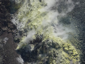
1) VOLCANOLOGICAL OBSERVATIONS: Normal explosive volcanic activity of Strombolian type on low and medium levels (4-11 events / h) and of medium intensity in the area of the North crater and medium in the area of the Center-South crater.
2) SEISMOLOGY: The seismological parameters do not show significant variations.
4) DEFORMATIONS: The island’s soil deformation monitoring networks did not show any significant changes to report for the period under review.
5) GEOCHEMISTRY: Medium-low SO2 flux
C / S Ratio – Latest values (C / S = 10) are average levels.
Isotope Ratio – There are no updates, the latest measurements (10/22/2020) are on average values and without significant changes.
6) SATELLITE OBSERVATIONS: The thermal activity in the summit area is at a low level.
VOLCANOLOGICAL OBSERVATIONS
During the period under observation, the eruptive activity of Stromboli was characterized by the analysis of the images recorded by the surveillance cameras INGV-OE located at 190 m altitude, Punta dei Corvi and 400 m.
In the area of the north crater, the N1 crater, characterized by three emission points, produced explosions of low intensity (less than 80 m high) to medium-high intensity (sometimes the projectiles reached 250 m high) emitting coarse materials (lapilli and bombs) sometimes mixed with fine materials (ash). The N2 mouthpiece, with three emission points, showed mainly a low / medium intensity explosive activity emitting coarse materials sometimes mixed with fine materials. The average frequency of the explosions varied from 4 to 10 events / h.
In the Center-South zone, the explosions emitting mainly fine materials, with an average intensity (the products reached 150 m in height).
The explosive activity showed frequency values varying between less than 1 and 2 events / h.
The amplitude of the volcanic tremor had values between low and medium-low.
STROMBOLI PRESS RELEASE [UPDATE n. 2]
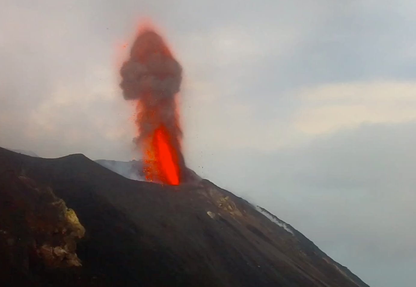
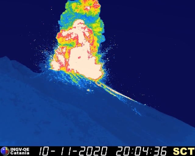
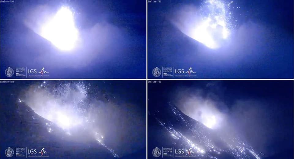
The National Institute of Geophysics and Volcanology, Osservatorio Etneo Observatory, announces that at 20.04.20 UTC there was a major explosion that affected the CentrSsud area of the crater terrace. The event lasted about 6 minutes and produced a vertical eruptive column that exceeded the height of Pizzo. The dispersion of the products took place mainly along the Sciara del Fuoco causing a generalized rolling of pyroclastic products, while a small part fell on the Pizzo Sopra La Fossa. The phenomenon ended at 20:10 UTC with at least three explosions of less intensity than the largest.
From the seismic point of view, the phenomenon, clearly visible at all the seismic stations of Stromboli, is characterized by a sequence of explosive events which started at 20: 03.50 (UTC). Regarding the amplitude of the volcanic tremor, no significant variation is reported.
Further updates will be communicated promptly and in any event within 3 hours of this press release.
STROMBOLI PRESS RELEASE [UPDATE n. 3]
The National Institute of Geophysics and Volcanology, Etneo Observatory, announces that the monitoring networks recorded the return of parameters to normal activity at 11:11 p.m. (10:11 p.m. UTC).
Source : INGV .
Photos : Web cam , INGV , LGS.
Italy / Sicily , Etna :
Weekly bulletin from November 02, 2020 to November 08, 2020 (issue date November 10, 2020)
SUMMARY OF THE STATE OF ACTIVITY:
In the light of surveillance data, it is highlighted:
VOLCANOLOGICAL OBSERVATIONS: Strombolian activity of variable frequency and intensity accompanied by discontinuous ash emissions at the New Southeast Crater. Intra-crater strombolian activity at the northeast crater, intracrater Strombolian activity at the Bocca Nuova crater, associated with low ash emissions and degassing. Degassing activity at the Voragine crater.
2) SEISMOLOGY: Increased rate of occurrence of fracturing earthquakes.
Stationarity of the parameters of the volcanic tremor.
3) INFRASOUND: Modest infrasound activity.
4) DEFORMATIONS: During the last week, the trend of the time series of the Etna soil deformation monitoring networks has not shown any significant changes. There are only very small permanent deformations associated with the seismic activity in some stations of the inclinometric network which in any case did not change the trend of the signals.
5) GEOCHEMISTRY: the flow of SO2 is at a medium-low level
HCl flow occurs at a medium-low level.
Soil CO2 flux is at low degassing levels.
The partial pressure of dissolved CO2 does not show significant changes.
The value of the C / S ratio is at medium-low levels (last measurement available on 10/16/2020).
The helium isotope ratio is at average values (last update 04/11/2020).
6) SATELLITE OBSERVATIONS: The thermal activity in the summit area is at a medium-low level.
VOLCANOLOGICAL OBSERVATIONS
During the week, the monitoring of the volcanic activity at the level of the summit craters of Etna was carried out by analyzing the images of the network of surveillance cameras of the INGV section of Catania, Osservatorio Etneo (INGV-OE) and through inspections carried out by INGV-OE staff on November 2, 3, 4, 5 and 6.
During the period under review, the summit craters were mainly characterized by strombolian intracrater activity with discontinuous ash emissions at the New Southeast Crater (NSEC) and by intracrater Strombolian activity at the Northeast Crater ( NEC). Intra-crater Strombolian activity also began at the Bocca Nuova (BN) crater, while degassing continued at the Voragine (VOR) crater, accompanied by rare and light ash emissions.
In particular, the New Southeast Crater (NSEC) was characterized by intracrater Strombolian activity, with explosions whose intensity and frequency were variable over time.
During the most energetic phases, the launches of coarse materials reached heights of several tens of meters at the edge and the products sometimes fell outside the crater, settling on the sides. There were also sporadic emissions of volcanic ash, with the formation of dilute clouds that were quickly dispersed by winds through the atmosphere.
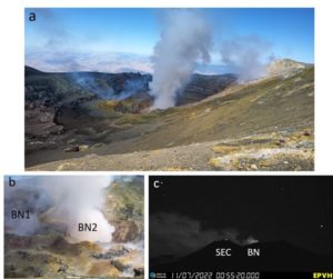
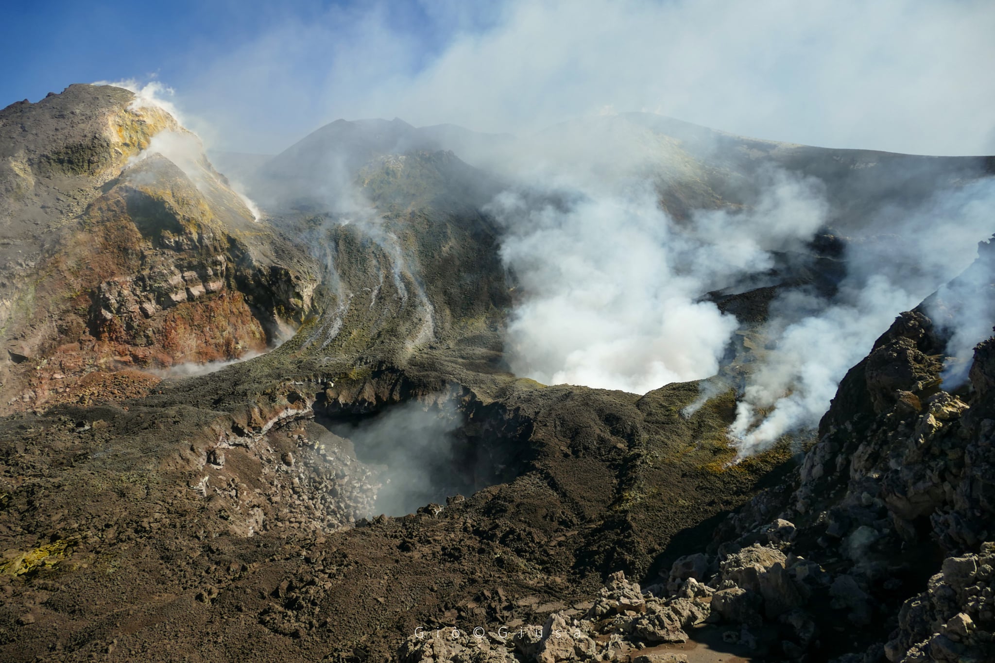
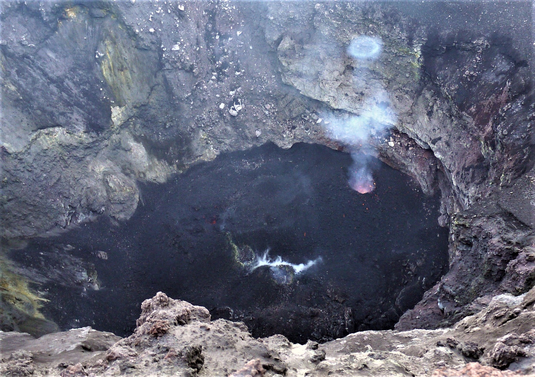
Regarding the Bocca Nuova crater, observations made during the inspections of the first days of the week showed that intense degassing continued, with occasional emissions of reddish ash from the pit crater formed in the area. West of the crater depression in early September. From November 5, BN 1 was affected by Strombolian activity, with launches of coarse material whose height sometimes exceeded the edge of the crater, but which did not fall on the edges of the crater terrace. The other pit crater formed in the center of the depression of the Bocca Nuova crater in April (BN 2) was affected by intense degassing and collapses of material from the vertical walls, which sometimes produced ash. A fumarolic degassing is also visible on the entire bottom and internal walls of the Bocca Nuova.
The Northeast Crater, with explosive activities from different mouths (note the ring of gas emitted by the mouth on the far right), October 22, 2020 (photo by Mauro Couteaux)
Concerning the northeast crater, the deep intracrater Strombolian activity continued with varying intensity; during the inspection on November 2, it was observed that at the bottom of the crater there were 4 vents but only 3 of them fuel the eruptive activity. In particular, Vent 1 produced Strombolian explosions approximately every 5-7 minutes with the emission of coarse materials. At mouth 2, rare explosions were observed interspersed with phases of « projection », mouth 3 produced a weak explosive activity associated with a continuous emission of gas under pressure, finally mouth 4 showed no eruptive activity but only a permanent thermal anomaly. Finally, the Voragine crater was affected by a slight degassing of the main slag cone.
Source : INGV.
Photos : Gio Giusa , INGV / Mauro Couteaux .
Iceland , Reykjanes Peninsula :
Around 370 earthquakes were located by the IMO¿s automatic SIL seismic network in the passing week, fewer than in week 44 where about 520 earthquakes were mesured. Most activity was measured at the Reykjanes Peninsula also north of the country.
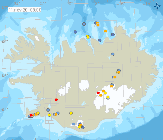
The larges measured eathquake this week measured M2.8 by just NE of Mt. Herðubreið. Two earthquakes M2.6 and 2.5 just west of lake Kleifarvatn were felt in the capital region on the 4. and 7. of November. One earthquake M1.0 was mesured by Grímsvötn. A short seismic swarm just north of Hrísey island that began in the previous week ended on November 3rd, until then around 20 earthquakes were mesured there in Week 45.
Source : Vedur .
Philippines : Taal / Pinatubo :
LAHAR ADVISORY FOR PINATUBO AND TAAL VOLCANOES 11 November 2020 10:00 AM
Based on the Severe Weather Bulletin #12 issued at 08:00 AM today by the Philippine Atmospheric Geophysical and Astronomical Services Administration (PAGASA), Severe Tropical Storm “ULYSSES” is expected to intensify into a typhoon in the next 12 to 24 hours affecting Metro Manila and portions of CALABARZON and Central Luzon. Heavy to intense rainfall can be expected on these areas which could generate volcanic sediment flows or lahars, muddy streamflows or muddy run-off in rivers and drainage areas on Pinatubo and Taal volcanoes. DOST-PHIVOLCS thus strongly recommends increased vigilance and readiness of communities in pre-determined zones of lahar and related hazards on these volcanoes.
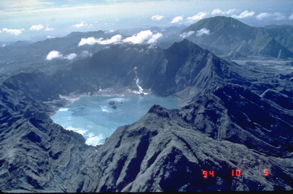
The Pinatubo eruption in the Philippines in 1991 created a new caldera with an average diameter of 2.5 km. The caldera collapse occurred as a result of the ejection of about 5 km3 of material during one of the largest eruptions of the 20th century and lowered the height of the volcano by about 300m. This 1994 view from the northwest shows a lake in the caldera and two small islands of a partially submerged lava dome that dates from 1992.
Prolonged and intense rainfall may generate non-eruption lahars on major rivers draining western Pinatubo Volcano where significant deposits of the 1991 PDCs remain on the watershed. Pinatubo lahars are likely be channel-confined and occur on the upper to middle reaches of the Sto. Tomas- Marella and Bucao River systems but may transition to muddy streamflows and floods on the lower reaches and affect adjacent communities of San Marcelino, San Narciso, San Felipe and Botolan, Zambales Province. Muddy streamflows may likewise be generated along the O’Donnell and Pasig-Potrero River systems draining the Pinatubo edifice to the north and southeast, respectively and affect downstream communities in Tarlac and Pampanga Provinces.
Prolonged and heavy rainfall may also generate muddy streamflow and muddy runoff around Taal Volcano, particularly on the slopes west of Taal Lake where thin remnant ash can be remobilized in streams and roads and overland of the lakeward slopes. In particular, muddy streamflow and runoff can recur on previously affected communities of Agoncillo and Laurel, Batangas Province.
Source : Phivolcs .
Photo : Ray Punungbayan, 1994 (Philippine Institute of Volcanology and Seismology).
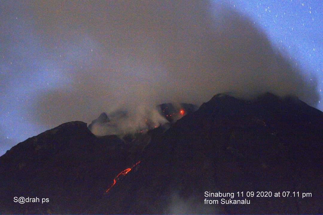
Indonesia , Sinabung :
The activity level has been at level III (SIAGA) since May 20, 2019 at 10:00 a.m. The Sinabung volcano (2460 m altitude) has been erupting since 2013.
The volcano was clear until it was covered in fog. The main crater was observed to emit white smoke of moderate intensity, with a high thickness, about 100 to 500 m above the peak. The weather is cloudy to rainy, with weak to moderate winds to the east and southeast. The air temperature is about 18-25 ° C. An eruption was observed with a height of 2000 m above the peak, a column of gray ash, hot avalanche clouds with a distance landslide from 1,500 to 2,500 m east and south-east, a lava avalanche with a slide distance of 500 to 1,000 m from the summit to the east and south-east.
According to the seismographs of November 10, 2020, it was recorded:
1 eruption earthquake
3 hot cloud avalanche earthquakes
32 avalanche earthquakes
5 emissions earthquakes.
12 low frequency earthquakes
7 hybrid / multiphase earthquakes
4 local tectonic earthquakes
2 distant tectonic earthquakes.
VOLCANO OBSERVATORY NOTICE FOR AVIATION – VONA .
Issued : November 10 , 2020 .
Volcano : Sinabung (261080)
Current Aviation Colour Code : ORANGE
Previous Aviation Colour Code : orange
Source : Sinabung Volcano Observatory
Notice Number : 2020SIN29
Volcano Location : N 03 deg 10 min 12 sec E 98 deg 23 min 31 sec
Area : North Sumatra, Indonesia
Summit Elevation : 7872 FT (2460 M)
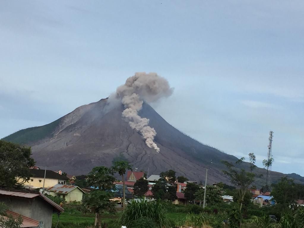
Wednesday November 4, 2020, at 08:26 WIB, lava avalanche flowing to the South-East with a sliding distance of 1000 meters from the summit. / CCTV footage from PGA Sinabung, PVMBG Geological Agency. /
Volcanic Activity Summary :
Eruption with volcanic ash cloud and pyroclastic flow at 09h50 UTC (16h50 local)
Volcanic Cloud Height :
Best estimate of ash-cloud top is around 14272 FT (4460 M) above sea level, may be higher than what can be observed clearly. Source of height data: ground observer.
Other Volcanic Cloud Information :
Ash-cloud moving to east southeast and pyroclastic flow to southeast as far as 2500 meters
Remarks :
Seismic activity is characterized by eruption quake and pyroclastic flow
Source : PVMBG . Magma Indonésie.
Photos : Sadrah Peranginangin .