
December 22 , 2018.
Alaska , Great Sitkin :
52°4’35 » N 176°6’39 » W,
Summit Elevation 5709 ft (1740 m)
Current Volcano Alert Level: ADVISORY
Current Aviation Color Code: YELLOW
Low-level unrest continues at Great Sitkin volcano. Numerous small earthquakes associated with the ongoing unrest continue to be recorded on the local seismic network. No eruptive activity was observed in cloudy satellite views of the volcano over the past day. No explosive activity was detected on a regional infrasound array on Adak Island.

Great Sitkin volcano is monitored with a local real-time seismic network, which will typically allow AVO to detect changes in unrest that may lead to an explosive eruption. Rapid detection of an ash-producing eruption would be accomplished using a combination of seismic, infrasound, lightning, and satellite data.
Source : AVO.
Photo : Auteur Inconnu
Colombia , Nevado del Ruiz ,
Subject: Activity bulletin of the Nevado del Ruiz volcano.
The level of activity continues at the level: Yellow activity level or (III): changes in the behavior of volcanic activity.
With regard to monitoring the activity of the Nevado del Ruiz volcano, the COLOMBIAN GEOLOGICAL SERVICE announces that:
During the past week, the seismicity caused by rock fracturing has shown a slight decrease in the number of earthquakes and released seismic energy compared to the previous week. The earthquakes were mainly located in the Arenas crater and in the North-East sector of the volcano, at depths between 0.6 and 7.0 km. The maximum magnitude recorded during the week was 1.1 ML (local magnitude), corresponding to the earthquake that occurred on December 11 at 3:50 pm (local time) in the crater Arenas, 1.7 km deep.

Seismicity related to the dynamics of the fluids within the ducts of the volcanic structure also showed a slight decrease in the number of earthquakes and released seismic energy compared to the previous week. This activity was characterized by earthquakes with low energy levels, long periods, very long periods and tremors. The earthquakes occurred mainly in the crater Arenas and its surroundings.
Volcanic deformation measured from electronic inclinometers, GNSS (Global Navigation Satellite System) stations and radar images has so far shown stability behavior without recording significant deformation processes of the volcanic structure.
The volcano continues to emit water vapor and gases into the atmosphere, among which sulfur dioxide (SO2) stands out, as evidenced by the values obtained by the SCANDOAS stations installed in the volcano area and the analysis of satellite images. During the week the NASA FIRMS and MIROVA portals reported several thermal anomalies of low energy level.
The column of gases and steam reached a maximum height of 1700 m, measured on the summit of the volcano on December 14. The direction of dispersion of the column was governed by the direction of the wind in the area, which predominated towards the Northwest and North of the volcano.
The Nevado del Ruiz volcano continues at the Yellow activity level.
Source : SGC.
Photos : SGC
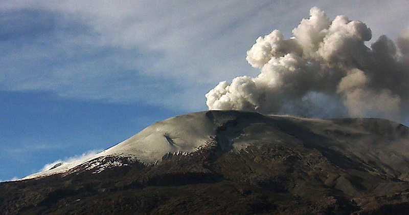
Mexico , Popocatepetl :
December 21, 11:00 am (December 21st, 5:00 pm GMT).
During the last 24 hours, through the monitoring systems of the Popocatépetl volcano, 116 exhalations have been identified, accompanied by water vapor, gas and light amounts of ash. In addition, four volcano-tectonic earthquakes were recorded today at 01:30, 01:31: 31, 01:31: 51 and 01:32, with a magnitude calculated respectively of M1.6, M1.5, M1.4 and M1. 7. During the night, it was possible to observe the crater with a continuous emission of water vapor and gas, but no incandescence was observed

At the time of writing, there is a slight emission of water vapor and gas that the winds are dispersing in a preferential direction to the southeast.
CENAPRED urges NOT to approach the volcano and in particular the crater, because of the risk of falling ballistic fragments, and in case of heavy rains to stay away from ravine bottoms because of the risk of landslides and flows mud.
The warning light of the Popocatepetl volcano is located at Amarillo Phase 2.
Source : Cenapred.
Photo : W Radio.
Philippines , Kanlaon :
KANLAON VOLCANO BULLETIN 22 December 2018 08:00 A.M.
Kanlaon Volcano’s seismic monitoring network recorded one (1) volcanic earthquake during the past 24 hours. Ground deformation data from continuous GPS measurements indicate pronounced inflation of the edifice since December 2017, signifying pressurization beneath the edifice. Sulfur dioxide (SO2) emission was measured at an average of 94 tonnes/day on 12 December 2018.

Alert Level 2 status prevails over Kanlaon Volcano, which means that the volcano is undergoing a moderate level of unrest due to probable intrusion of magma at depth that may or may not lead to a magmatic eruption. The local government units and the public are strictly reminded that entry into the 4-kilometer radius Permanent Danger Zone (PDZ) is strictly prohibited due to the further possibilities of sudden and hazardous steam-driven or phreatic eruptions. Civil aviation authorities must also advise pilots to avoid flying close to the volcano’s summit as ejecta from any sudden phreatic eruption can be hazardous to aircraft.
DOST-PHIVOLCS is closely monitoring Kanlaon Volcano’s activity and any new development will be relayed to all concerned.
Source : Phivolcs.


No comment yet, add your voice below!