January 15 , 2018. EN . Mayon , Kadovar , Agung , Turrialba , Poas , Tenorio .

January  15 ,  2018.


Mayon , Philippines :

MAYON VOLCANO BULLETIN 14 January 2018 8:00 PM

This serves as a notice for the raising of Mayon Volcano’s status from Alert Level 2 (increasing unrest) to Alert Level 3 (increased tendency towards hazardous eruption).
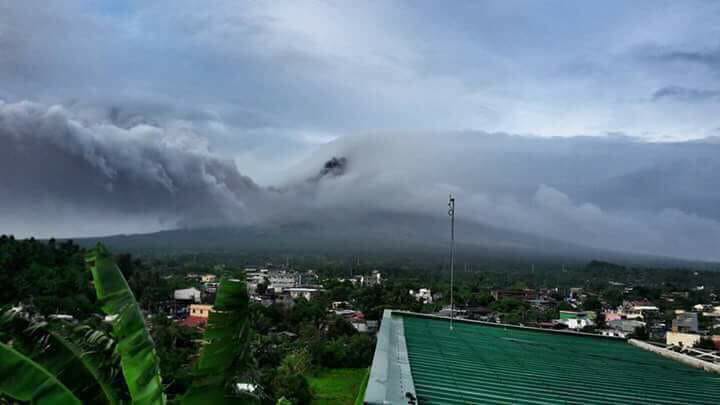
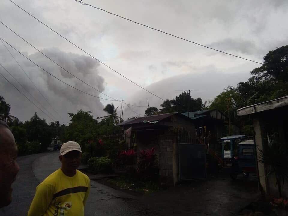
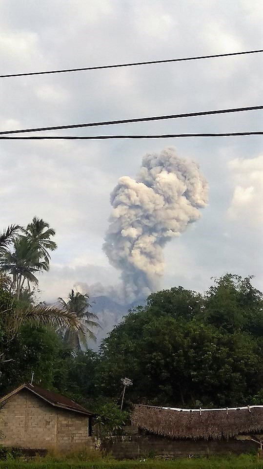
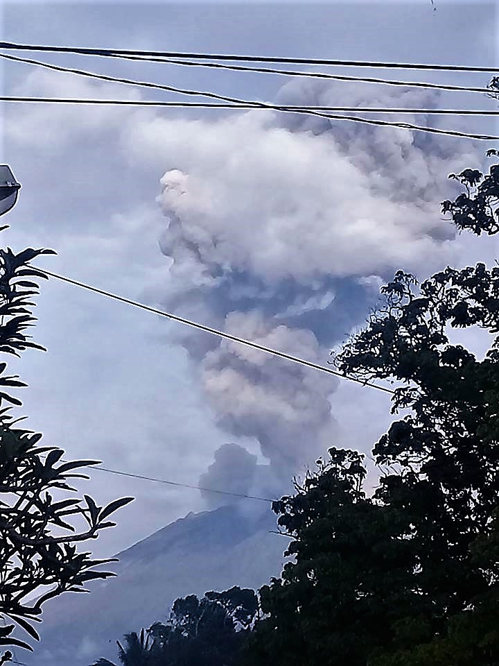
For the past 24 hours, Mayon Volcano in Albay Province has noticeably increased its unrest. After three (3) phreatic (steam-driven) eruptions and 158 rockfall events between 4:21 PM 13 January and 7:25 PM 14 January, Mayon’s summit crater is now exhibiting bright crater glow that signifies the growth of a new lava dome and beginnings of lava flow towards the southern slopes.

MAYON VOLCANO BULLETIN (UPDATED) 15 January 2018 1:30 P.M.

Two lava collapse events occurred today at Mayon Volcano, Albay that produced rockfall and small-volume pyroclastic density currents. These occurred at 09:41 AM and 10:05 AM that lasted five (5) minutes and seven (7) minutes, respectively, based on seismic record. These events appear to have originated from the lava front and produced an ash cloud that drifted to the southwest sector. Ashfall were reported in Brgys. Travesia, Muladbucad Grande, Maninila, Masarawag, Poblacion, Iraya, Ilawod, Calzada, Inamnan Grande, Inamnan Pequeno, Maguiron, Quitago and Mauraro in the municipality of Guinobatan; Brgys. Cabangan, Anoling, Sua, Tumpa, Quirangay, Gapo, Sumlang, Brgys. 1 to 7, in the municipality of Camalig.
A degassing event at 11:07 AM that lasted eight (8) minutes produced a grayish to dirty white ash column with a maximum of height of approximately 1000 meters above the summit before drifting west-southwest.


In view thereof, PHIVOLCS-DOST is now raising the alert status of Mayon Volcano from Alert Level 2 to Alert Level 3. This means that Mayon is exhibiting relatively high unrest and that magma is at the crater and that hazardous eruption is possible within weeks or even days. It is therefore recommended that the 6-km radius Permanent Danger Zone (PDZ) and a 7-km Extended Danger Zone (EDZ) on the southern flank be enforced due to the danger of rockfalls, landslides and sudden explosions or dome collapse that may generate hazardous volcanic flows. Increased vigilance against pyroclastic density currents, lahars and sediment-laden streamflows along channels draining the edifice is also advised. Civil aviation authorities must also advise pilots to avoid flying close to the volcano’s summit as ash from any sudden eruption can be hazardous to aircraft. Based on the seasonal wind pattern, ash fall events may most likely occur on the southwest side of the volcano.

DOST-PHIVOLCS maintains close monitoring of Mayon Volcano and any new development will be communicated to all concerned stakeholders.

Source : Phivolcs

Photo : Joshua Eric Velasco Dandal , grâce à Sherine France.


Kadovar / Biem , Papua New Guinea :

PNG Governor orders evacuation of second volcano as eruption fears mount.

Papua New Guinea authorities have ordered the evacuation of some 3,000 people from Biem Island amid fears of a volcanic eruption, as the country’s Prime Minister directed national resources to neighbouring Kadovar island.

Biem Island is only around 12 kilometres west of Kadovar Island, where giant plumes of ash and cloud have forced around 700 people to be evacuated in the past week.
The Prime Minister’s office warned tremors from that volcano posed a tsunami risk to the mainland’s north coast and surrounding islands — including Biem Island and nearby Ruprup Island, where evacuees from Kadovar had been sent.
A statement from Prime Minister Peter O’Neill said national government agencies had been stood up to respond to the activity on Kadovar Island.
« Volcanoes are very unpredictable, we are hearing various reports that activity has been building up and we need to take all precautions to keep our people safe, » the statement said.

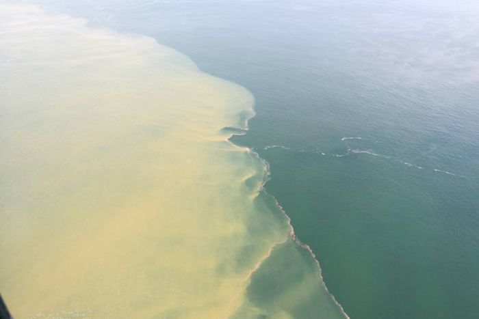
Photo: Aerial flyover teams took photos of the yellowing waters off Biem’s coast. (Supplied: Office of East Sepik Governor)


Meanwhile the Governor of East Sepik province, Allan Bird, said military personnel had warned of an « imminent volcanic eruption » on Biem Island.
On the advice he had from experts, Mr Bird said the island is « a time bomb, » and ordered its residents to be evacuated.

« Our priority right now is we’re hoping to get all the people off before the volcanos explode, and we have no idea when that’s going to happen. »
Neither Biem or Kadovar islands have dedicated seismic monitoring technology, so scientists and authorities had been monitoring the volcano from aerial flyovers and satellite imagery.
« There is yellowing of the ocean around the island, which the volcanologists tell me is magma moving up, it is forcing iron to dissolve into the sea water and that is causing the discolouration, » Mr Bird said.

Eruption on Biem ‘unlikely’, says volcanologist
Despite reports of tremors and plumes from Biem Island, volcanologist Steve Saunders said any sort of chain reaction started by the Kadovar activity was « unlikely ».
« Reports of hot springs … or sulphur plumes in the sea [near Biem] are probably old thermal springs, they’ve been there for decades, » said Mr Saunders, the Chief Geodetic Surveyor at the Rabaul Volcano Observatory.
« It’s just an ongoing situation on the islands, that they’ve got thermal activity. »

The Observatory, which is PNG’s national body for monitoring volcanos, was planning to send a team to Kadovar and Ruprup islands in coming days for an official seismic reading.
Mr Saunders said reports of tremors on Biem Island could likely be attributed to the seismic activity on Kadovar, which remained the biggest risk for the region, rather than from the Biem volcano itself.


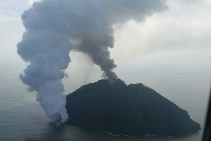
Photo: Plumes of smoke from Kadovar Island continued billowing into the weekend. (Supplied: Office of East Sepik Governor)

Around 5,000 people on three islands to be relocated
Although there was uncertainty surrounding the Biem volcano’s activity, authorities in East Sepik were working on moving civilians away from any possible eruption.
Mr Bird said the province had been waiting for the PNG Defence Force to send landing craft to Ruprup Island to begin evacuating people to the mainland, but following the weekend’s reports he turned his attention to Biem Island.
He said he had requested a civilian vessel, owned by a Tuna company, to head towards Ruprup Island « so we can try to evacuate both locations concurrently ».
Mr Bird said around 3,000 people lived on Biem Island, so officials were facing the prospect of relocating about 5,000 people from the three islands to the mainland.

Latest report from Hon. Governor of ESP Allan Bird:
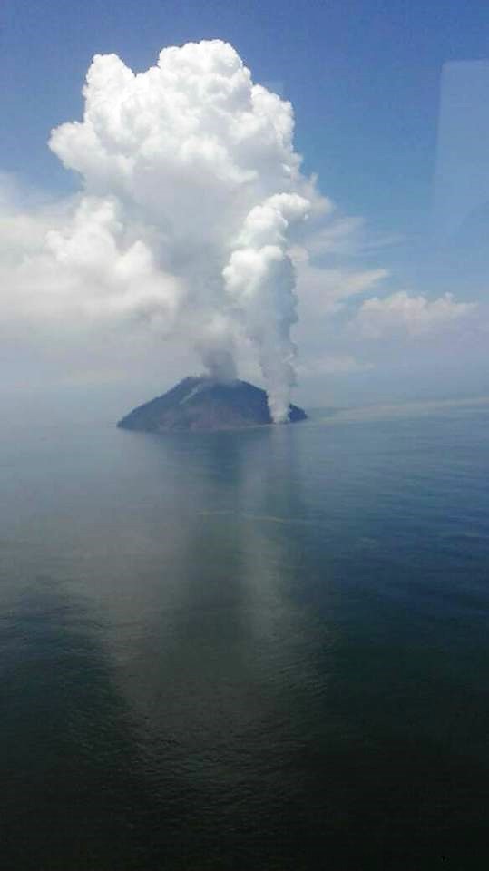
These are the latest pictures from Kadovar island. As of last night magma broke the surface and has produced a 12km high ash and steam cloud. I woke up this morning and Wewak was covered in a smokey haze. We noticed a similar 12km high steam cloud over Biem island and we have sent a team to investigate. We circled Biem island in the chopper and noticed a sulphur plume next to shore on the south west of Biem. You can see this in the picture above. I hope Biem does not blow as well.

A Second island volcano is erupting off Wewak in East Sepik Province.
Biem Island, east of the erupting Kavodar Island, became active at the weekend, East Sepik Governor Allan Bird said yesterday.
“At 1am (on Saturday), I was informed that Biem island volcano, as we feared, is now also becoming active,” Mr Bird said in an email.
“We now have two volcanoes in the process of erupting concurrently. We are doing our best and deploying all our assets to this effort.”
Last week the Rabaul Volcanic Observatory had warned that the ongoing eruption at Kadovar could stir volcanoes on the nearby islands of Ruprup and Biem to follow suit.
Mr Bird said following the latest eruption he had dispatched the PNG Defence Force landing craft to evacuate the 1700 Kavodar evacuees who had been moved to Ruprup Island.
“I have changed our engagement in the disaster.
“Biem is now our priority because there are more than 3000 people on that island.
“I have directed all efforts to Biem Island as our top priority. I have also requested the use of the South Sea Tuna vessel to immediately steam to Ruprup island and begin evacuating our people there,” Mr Bird.

Source : ABC.net .au, News PNGfacts.com

Photos : Office of East Sepik Governor , Tweedy Malagian
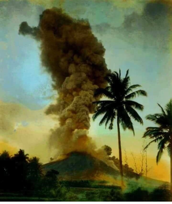
 

Agung , Indonesia :

On the basis of the results of the visual and instrumental data analysis and considering the potential threats of danger, on November 27, 2017 at 06:00, the status of G. Agung was raised from Level III (SIAGA) to Level IV (AWAS) . Since yesterday and until today visually the volcano is usually covered with fog. The emission of white fumes, low intensity and low pressure, reaches a height of about 100 m above the summit and tilts to the east. At night, the glow of the incandescent lava is not observed.

The records of the seismographs dated January 14, 2018 noted:
24 emission earthquakes
6 shallow volcanic earthquakes (VB)
7 deep volcanic earthquakes (VA)
No local tectonic earthquake (TL)
No low frequency earthquake (LF)
A continuous tremor with an amplitude of 1 to 5 mm and a dominant value of 1 mm.

As of January 15, 2018 (00:00 to 18:00) it has been registered:
No earthquake emission
1 shallow volcanic earthquakes (VB)
2 deep volcanic earthquakes (VA)
No local tectonic earthquake (TL)
No low frequency earthquake (LF)
A continuous tremor with an amplitude of 1 to 2 mm and a dominant value of 1 mm.

Recommendations:
The communities around G. Agung and mountaineers / visitors / tourists should not climb, climb or do any activity in the danger zone around the G. Agung crater area and in all areas within 6 km from the crater of G. Agung. The estimated area risks are dynamic and continuously assessed and can be modified at any time based on the most recent observational data from G. Agung.
Level IV (AWAS) is only valid for a 6 km radius as mentioned above. Outside the activity area, everything can work like NORMAL and always SAFE.

VOLCANO OBSERVATORY NOTICE FOR AVIATION – VONA.

Issued: January 14 , 2018.
Volcano: Agung (264020)
Current Aviation Colour Code: ORANGE
Previous Aviation Colour Code: orange
Source: Agung Volcano Observatory
Notice Number: 2018AGU07
Volcano Location: S 08 deg 20 min 31 sec E 115 deg 30 min 29 sec
Area: Bali, Indonesia
Summit Elevation: 10054 FT (3142 M)

Volcanic Activity Summary:
Eruption with volcanic ash cloud at 23h23 UTC ( 07h23 local). Eruption and ash emission is not continuing

Volcanic Cloud Height:
Best estimate of ash-cloud top is around 16454 FT (5142 M) above sea level, may be higher than what can be observed clearly. Source of height data: ground observer.

Other Volcanic Cloud Information:
Ash-cloud moving to North – Northeast

Remarks:
Seismic activity is dominated by shallow volcanic earthquake events

Sources : VSI , Magma .

Photos : Pandeni Addhe Dewii , Rai Dananjaya .


Turrialba , Poas , Tenorio , Costa Rica :

Activity report of volcanoes Turrialba, Poás, and Tenorio:
January 14, 2018, Updated at 11:00 o’clock.

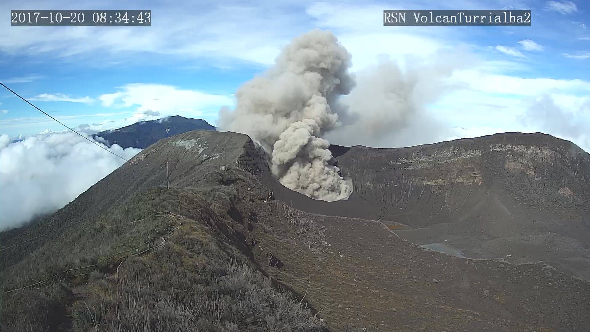
Turrialba Volcano: activity over the last 24 hours:
The Turrialba volcano continues its permanent degassing. No ash emission was detected.
Seismic activity over the last 24 hours has remained at a low level.
At the time of this report, winds at the top of the volcano are heading southward.

Poás Volcano : activity over the last 24 hours:
Poás continues with permanent degassing. The plume rises less than 500m above the bottom of the crater. No ash emission was detected.
The level of seismic activity is low. In general, most of the seismic signals recorded on the Poas are essentially generated by background noise produced by external factors.
At the time of this report, the winds at the top of the volcano are variable, but they are oriented mainly to the southwest.

Tenorio Volcano: activity over the last 24 hours:
No earthquakes were located in the area by the automatic system.

OVSICORI-UNA remains vigilant on seismic and volcanic activity.

Source : Ovsicori

Photo : Archive RSN

January 14 , 2018. EN . Mayon , Kilauea , Dukono , Piton de la Fournaise .

January 14 ,  2018.


Mayon , Philippines :

MAYON VOLCANO BULLETIN 14 January 2018 8:00 A.M.

Mayon Volcano’s seismic monitoring network recorded seventy-eight (78) rockfall events during the past 24 hours. Degassing at the active vents could not be observed due to thick clouds covering the summit. At 4:21 PM yesterday, Mayon Volcano generated a phreatic eruption (steam-driven) that propelled a grayish steam and ash plume approximately 2500 m high that was drifted to the southwest. Based on seismic records the activity lasted approximately 1 hour and 47 minutes. Traces of ash fell on Barangays Anoling, Sua, Quirangay, Tumpa, Ilawod and Salugan of Camalig and in Barangays Tandarora, Maninila and Travesia in Guinobatan. Sulfuric odor was noted by residents of Camalig town proper. Rumbling sounds were heard by residents of Brgy. Anoling, Camalig. Faint crater glow has been first observed at 10:16 PM. Precise leveling data obtained on November 7 to 11, 2017 indicated slight inflation of the edifice relative to September 2017. This is also exhibited in increased rates in the inflationary trends recorded by continuous GPS and tilt since October and November 2017, respectively. Sulfur dioxide (SO2) emission was measured at an average of 856 tonnes/day on 03 December 2017.

MAYON VOLCANO BULLETIN 14 January 2018 10:50 AM

Another phreatic eruption occurred today at Mayon Volcano in Albay. This began at 8:49 am and lasted approximately 5 minutes based on seismic record. The event produced a grayish steam and ash plume that was largely obscured by summit clouds. Sulfurous odor was detected and rumbling sounds were heard by residents of Brgy. Anoling, Camalig.


MAYON VOLCANO BULLETIN 14 January 2018 12:30 AM

This serves as a notice for the raising of Mayon Volcano’s status from Alert Level 1 (abnormal) to Alert Level 2 (increasing unrest).
Mayon Volcano in Albay Province generated a phreatic eruption (steam-driven) that propelled a grayish steam and ash plume approximately 2500 m high that was drifted to the southwest. Based on seismic records the activity started around 4:21 PM of January 13, 2018 and lasted approximately 1 hour and 47 minutes.   This indicates the pressurization of the volcano by the rise of the magma or the disturbance of the underground hydrothermal system of Mayon.

In view thereof, DOST-PHIVOLCS is raising the Alert Level of Mayon Volcano from Alert Level 1 (abnormal) to Alert Level 2 (increasing unrest). This means that current unrest is probably of magmatic origin, which could lead to more phreatic eruptions or eventually to hazardous magmatic eruptions. The public is strongly advised to be vigilant and desist from entering the six (6) kilometer-radius Permanent Danger Zone (PDZ) to minimize risks from sudden explosions, rockfall and landslides. In case of ash fall events, which are most likely to affect communities on the western and southwestern flanks downwind of Mayon’s crater, people should cover their nose and mouth with damp, clean cloth or dust mask. Civil aviation authorities must also advise pilots to avoid flying close to the volcano’s summit as ash from any sudden eruption can be hazardous to aircraft. Based on the seasonal wind pattern, ash fall events may most likely occur on the southwest side of the volcano. DOST-PHIVOLCS maintains close monitoring of Mayon Volcano and any new development will be communicated to all concerned stakeholders.

Provincial disaster officials in Albay ordered the immediate evacuation of residents from 16 villages at the foot of the volcano.
The head of the public security and emergency bureau of Albay, Cedric Daep, announced that the people came from the municipalities of Daraga, Camalig, Guinobatan, Malilipot, the city of Tabaco and the city of Ligao.
Evacuees will be housed in public primary schools designated by local government units in the corresponding cities.

Source : Phivolcs

Photos : Christopher Dy-Liacco Flores , Joey Sarte Salceda.

Kilauea , Hawai :

19°25’16 » N 155°17’13 » W,
Summit Elevation 4091 ft (1247 m)
Current Volcano Alert Level: WATCH
Current Aviation Color Code: ORANGE

Activity Summary:
No significant change. Lava is not entering the ocean at this time. Kīlauea continues to erupt at its summit and from the Puʻu ʻŌʻō vent on its East Rift Zone. The episode 61g lava flow is producing scattered surface flow activity. Active lava flows pose no threat to nearby communities at this time. This morning, the surface of the lava lake at the Kīlauea summit was roughly 33 m (108 ft) below the floor of Halemaʻumaʻu. Inflation continued over the past day, and there have been no significant changes in seismicity or gas release across the volcano.

Summit Observations:
Summit tiltmeters recorded continued inflationary tilt over the past day, and the lake level rose slightly. This morning the lake was roughly 33 m (108 ft) below the floor of Halemaʻumaʻu. Sulfur dioxide emission rates remain high. Seismicity is at normal levels, with tremor fluctuations related to lava lake spattering.

Puʻu ʻŌʻō Observations:
No significant changes are evident at Puʻu ʻŌʻō. The sulfur dioxide emission rate from the East Rift Zone vents has been steady over the past several months and remains significantly lower than the summit emission rate.

Lava Flow Observations:
The episode 61g flow is still active, but no lava is flowing into the ocean. Surface lava flow activity persists on the upper portion of the flow field, on the pali, and in scattered areas along the coastal plain. These lava flows pose no threat to nearby communities at this time.

Source : HVO

Photos : Bruce Omori.


Dukono , Indonesia :

VOLCANO OBSERVATORY NOTICE FOR AVIATION – VONA.

Issued: January 12 , 2018.
Volcano: Dukono (268010)
Current Aviation Colour Code: ORANGE
Previous Aviation Colour Code: orange
Source: Dukono Volcano Observatory
Notice Number: 2018DUK07
Volcano Location: N 01 deg 41 min 35 sec E 127 deg 53 min 38 sec
Area: North Maluku, Indonesia
Summit Elevation:3933 FT (1229 M)

Volcanic Activity Summary:
Eruption with volcanic ash cloud at 21h57 UTC (06h57 local).

Volcanic Cloud Height:
Best estimate of ash-cloud top is around 4893 FT (1529 M) above sea level, may be higher than what can be observed clearly. Source of height data: ground observer.

Other Volcanic Cloud Information:
Ash cloud moving to southwest.

Remarks:
Eruption and ash emission is continuing.


Activity Level of Level II (WASPADA). The Dukono (1229 m above sea level) has a continuous eruption. Since yesterday until this morning, visually, the summit of the volcano can be observed clearly until it is covered with fog. The smoke emitted from the crater is white / gray, of medium thickness and rises from 700 to 800 m. The wind is blowing weakly towards the West.

The seismographs, dated January 12, 2018, recorded:
Ash emissions associated with continuous tremors with an amplitude of 0.5 to 10 mm (dominant 2 mm).
3 earthquakes of eruption.
No deep volcanic earthquakes (VA).
No local tectonic earthquake (TL).
There was no rumbling heard from the Dukono Post, 10 km north of the summit.

Recommendation: The communities around G. Dukono and visitors / tourists should not move, climb or approach the Malupang Warirang crater within 2 km.

Sources : VSI , Magma .

Photo : Sylvain Chermette  / 80 jours voyage.


Piton de la Fournaise , La Réunion :

21 ° 14’38 « S
55 ° 42’29 « E
Altitude: 2632m
Alert level: Vigilance.

Seismology
– Number of landslides of 13-01-2018: 5

Areas affected by landslides: Summit cone, Enclos.
– Number of volcano-tectonic earthquakes (VT) from 13-01-2018: 0
– Volcanano-tectonic earthquake of greater magnitude of 13-01-2018:
Duration: 0 s
Duration Magnitude: 0.00

Location of earthquakes over 2 months. Only localizable earthquakes have been represented on the map.
The observatory records seismic events not shown on this map because they are not localizable due to their low magnitude.
To see the number of earthquakes detected by the Observatory’s networks, you can refer to its last Activity Bulletin.

Deformities:
– The GPS of the summit zone record an inflation, witness of the putting in pressure of a superficial source.
– GPS in the far field record inflation, witnessing the setting in pressure of a deep source.

Illustration of the summit deformation over 2 months. Here is shown a baseline (variation of distance between two GPS receivers) crossing the crater Dolomieu (see location). A rise is synonymous with elongation and therefore swelling of the volcano; conversely, a decrease is synonymous with contraction and therefore deflation of the volcano. Any periods colored in light pink correspond to eruptions.

Geochemistry:
Low concentrations of H2S (coupled with water vapor) and SO2 (coupled with CO2) in the summit emissions of Piton de la Fournaise.
Further information:
The high inflation currently observed in the Piton de la Fournaise summit zone could be linked to hydrothermal activity following heavy rains in recent days.

Source : OVPF


14 Janvier 2018 . FR . Mayon , Kilauea , Dukono , Piton de la Fournaise .

14 Janvier  2018.


Mayon , Philippines :

BULLETIN D’ ACTIVITE DU VOLCAN MAYON , 14 janvier 2018 , 8:00 A.M.

Le réseau de surveillance sismique du volcan Mayon  a enregistré soixante-dix-huit (78) événements de chutes de pierres au cours des dernières 24 heures. Le dégazage au niveau des bouches actives n’a pas pu être observé en raison des épais nuages ​​couvrant le sommet. À 16h21 hier, le volcan Mayon a généré une éruption phréatique ( vapeur) qui a propulsé un panache grisâtre de fumée et de cendres d’environ 2500 m de haut qui a été dérivé vers le Sud-Ouest. Sur la base des enregistrements sismiques, l’activité a duré environ 1 heure et 47 minutes. Des chutes de cendres sont retombées sur Barangays Anoling, Sua, Quirangay, Tumpa, Ilawod et Salugan de Camalig et sur Barangays Tandarora, Maninila et Travesia dans Guinobatan. Une odeur de soufre a été notée par les habitants de la ville de Camalig proprement dite. Des bruits de grondement ont été entendus par les résidents de Brgy. Anoling, Camalig. Une faible lueur du cratère a été observée pour la première fois à 22h16. Les données de nivellement précises obtenues du 7 au 11 novembre 2017 ont indiqué une légère inflation de l’édifice par rapport à septembre 2017. Cela se manifeste également par une augmentation des taux inflationnistes enregistrés par GPS et enregistreurs d’inclinaison continus depuis octobre et novembre 2017, respectivement. Les émissions de dioxyde de soufre (SO2) ont été mesurées à une moyenne de 856 tonnes / jour le 03 décembre 2017.

BULLETIN D’ ACTIVITE DU VOLCAN MAYON , 14 janvier 2018  , 10:50.

Une autre éruption phréatique s’est produite aujourd’hui sur le volcan Mayon . Cela a commencé à 8h49 et a duré environ 5 minutes en fonction des données sismiques. L’événement a produit un panache grisâtre de vapeur et de cendres qui a été en grande partie obscurci par des nuages ​​du sommet. Une odeur de soufre a été détectée et des grondements ont été entendues par les habitants de Brgy. Anoling, Camalig.


BULLETIN D’ ACTIVITE DU VOLCAN MAYON , 14 janvier 2018 , 12:30

Ceci sert comme un avis pour l’élévation du statut d’activité du volcan Mayon , du niveau d’alerte 1 (anormal) au niveau d’alerte 2 (agitation croissante).
Le volcan Mayon, dans la province d’Albay, a généré une éruption phréatique (entraînée par la vapeur) qui a propulsé un panache grisâtre de vapeur et de cendres d’environ 2500 m de haut qui a été dérivé vers le Sud-Ouest. D’après les données sismiques, l’activité a commencé vers 16 h 21 le 13 janvier 2018 et a duré environ 1 heure et 47 minutes.  Ceci indique la pressurisation de l’édifice par la remontée du magma ou la perturbation du système hydrothermal souterrain du Mayon.

Dans ce contexte, le DOST-PHIVOLCS élève le niveau d’alerte du volcan Mayon du niveau d’alerte 1 (anormal) au niveau d’alerte 2 (augmentation des troubles). Cela signifie que les troubles actuels sont probablement d’origine magmatique, ce qui pourrait conduire à plus d’éruptions phréatiques ou éventuellement à des éruptions magmatiques dangereuses. Il est fortement recommandé au public d’être vigilant et de s’abstenir d’entrer dans la zone de danger permanent (ZPP) de six (6) kilomètres de rayon afin de minimiser les risques d’explosions soudaines, de chutes de pierres et de glissements de terrain. Dans le cas de chutes de cendres, qui sont susceptibles d’affecter les communautés situées sur les flancs Ouest et Sud-Ouest du cratère du Mayon, les gens doivent se couvrir le nez et la bouche avec un chiffon humide et propre ou un masque anti-poussière. Les autorités de l’aviation civile doivent également conseiller aux pilotes d’éviter de voler à proximité du sommet du volcan car les cendres provenant de toute éruption soudaine peuvent être dangereuses pour les aéronefs. Selon la configuration des vents saisonniers, les chutes de cendres peuvent très probablement se produire du côté Sud-Ouest du volcan.

Le DOST-PHIVOLCS maintient une surveillance étroite du volcan Mayon et tout nouveau développement sera communiqué à toutes les parties prenantes concernées.

Les responsables provinciaux des catastrophes à Albay ont ordonné l’évacuation immédiate des résidents de 16 villages au pied du volcan.
Le chef du bureau de la sécurité publique et des urgences d’Albay, Cedric Daep, a annoncé que les personnes venaient des municipalités de Daraga, Camalig, Guinobatan, Malilipot, la ville de Tabaco et la ville de Ligao.
Les personnes évacuées logeront dans les écoles primaires publiques désignées par les unités gouvernementales locales dans les villes correspondantes.

Source : Phivolcs

Photos : Christopher Dy-Liacco Flores , Joey Sarte Salceda.


Kilauea , Hawai :

19 ° 25’16 « N 155 ° 17’13 » W,
Sommet : 4091 pi (1247 m)
Niveau d’alerte volcanique actuel: ATTENTION
Code couleur actuel de l’aviation: ORANGE

Résumé de l’activité:
Pas de changement significatif. La lave n’entre pas dans l’océan en ce moment. Le Kīlauea continue son éruption à son sommet et à partir de l’évent Pu’u’Ō’ō sur la zone de Rift Est. L’écoulement de lave de l’épisode 61g produit une activité de flux de surface dispersée. Les coulées de lave actives ne présentent aucune menace pour les communautés avoisinantes en ce moment. Ce matin, la surface du lac de lave au sommet du Kīlauea était à environ 33 m (108 pi) sous le plancher du cratère Halema’uma’u. L’inflation s’est poursuivie au cours de la dernière journée, et il n’y a pas eu de changements significatifs dans la séismicité ou la libération de gaz sur le volcan.

Observations du Sommet:
Les inclinomètres du sommet ont enregistré une inclinaison inflationniste continue au cours de la dernière journée et le niveau du lac s’est légèrement élevé. Ce matin, le lac se trouvait à environ 33 m (108 pi) sous le plancher du cratère Halema’uma’u. Les taux d’émission de dioxyde de soufre restent élevés. La sismicité est à des niveaux normaux, avec des fluctuations de tremor liées aux éclaboussures du lac de lave.

Observations sur Pu’u’Ō’ō :
Aucun changement significatif n’est évident sur Pu’u’Ō’ō. Le taux d’émission de dioxyde de soufre provenant des évents de la zone du Rift Est a été stable au cours des derniers mois et reste significativement inférieur au taux d’émission du sommet.

Observations des coulée de lave:
L’écoulement de l’épisode 61g est toujours actif, mais aucune lave ne coule dans l’océan. L’activité du flux de lave de surface persiste sur la partie supérieure du champ d’écoulement, sur le Pali et dans des zones dispersées le long de la plaine côtière. Ces coulées de lave ne représentent aucune menace pour les communautés avoisinantes en ce moment.

Source : HVO

Photos : Bruce Omori


Dukono , Indonésie :

AVIS D’OBSERVATION DU VOLCAN POUR L’AVIATION – VONA.

Délivré: 12 Janvier 2018.
Volcan: Dukono (268010)
Code  couleur actuel de l’aviation: ORANGE
Code couleur aviation précédent: orange
Source: Observatoire du volcan Dukono
Numéro de l’avis: 2018DUK07
Localisation du volcan : N 01 deg 41 min 35 sec E 127 deg 53 min 38 sec
Région: Maluku du Nord, Indonésie
Altitude du sommet: 3933 FT (1229 M)

Résumé de l’activité volcanique:
Éruption avec nuage de cendres volcaniques à 21h57 UTC (06h57 local).

Hauteur du nuage volcanique:
La meilleure estimation du sommet des nuages de cendres est d’environ 4893 FT (1529 M) au-dessus du niveau de la mer, peut être supérieure à ce qui peut être observé clairement. Source de données de hauteur: observateur au sol.

Autres informations sur le nuage volcanique:
Nuage de cendres se déplaçant vers le Sud-Ouest

Remarques:
L’éruption et l’émission de cendres se poursuivent.

Niveau d’activité de niveau II (WASPADA). Le Dukono (1229 m au-dessus du niveau de la mer) présente une éruption continue. Depuis hier jusqu’à ce matin , visuellement , le sommet du volcan peut être observé clairement jusqu’à ce qu’il soit couvert de brouillard. La fumée émise depuis le cratère est de couleur blanche / grise , de moyenne épaisseur et monte de 700 à 800 m. Le vent souffle faiblement vers l’Ouest.

Les sismographes , en date du 12 janvier 2018 , ont enregistré:
Des émissions de cendre associées à des tremors continus d’une amplitude de 0,5 à 10 mm (dominante 2 mm).
3 tremblements de terre d’ éruption  .
Aucun séisme volcanique profond (VA) .
Aucun séisme tectonique local (TL) .
Il n’y a pas eu de grondement entendus depuis le Dukono Post, à 10 km au Nord du sommet.
Recommandation: Les communautés autour du G. Dukono et les visiteurs / touristes ne doivent pas se déplacer, grimper et approcher du cratère Malupang Warirang dans un rayon de 2 km.

Sources : VSI , Magma .

Photo : Sylvain Chermette  / 80 jours voyage.


Piton de la Fournaise , La Réunion :

21°14’38 » S
55°42’29 » E
Altitude : 2632m

Niveau d’alerte : Vigilance.

Sismologie
– Nombre d’éboulements du 13-01-2018 : 5
Zones concernées par les éboulements : Cône sommital , Enclos.

– Nombre de séismes volcano-tectoniques (VT) du 13-01-2018 : 0
– Séisme volcano-tectonique de plus grande magnitude du 13-01-2018 :
Durée : 0 s
Magnitude de durée : 0.00

Localisation des séismes sur 2 mois. Seuls les séismes localisables ont été représentés sur la carte.
L’observatoire enregistre des évènements sismiques non représentés sur cette carte car non localisables, en raison de leur trop faible magnitude.
Pour prendre connaissance du nombre de séismes détectés par les réseaux de l’observatoire, vous pouvez vous reporter à son dernier Bulletin d’Activité.


Déformations:
– Les GPS de la zone sommitale enregistrent une inflation, témoin de la mise en pression d’une source superficielle.

– Les GPS en champ lointain enregistrent une inflation, témoin de la mise en pression d’une source profonde.

Illustration de la déformation sommitale sur 2 mois. Est ici représentée une ligne de base (variation de distance entre deux récepteurs GPS) traversant le cratère Dolomieu (cf. localisation). Une hausse est synonyme d’élongation et donc de gonflement du volcan; inversement une diminution est synonyme de contraction et donc de dégonflement du volcan. Les éventuelles périodes coloriées en rose clair correspondent aux éruptions.

Géochimie:
Faibles concentrations de H2S (couplé à la vapeur d’eau) et de SO2 (couplé au CO2) dans les émissions sommitales du Piton de la Fournaise.
Informations complémentaires
La forte inflation actuellement observée au niveau de la zone sommitale du Piton de la Fournaise pourrait être liée à une activité hydrothermale faisant suite aux fortes pluies de ces derniers jours.

Source : OVPF


13 Janvier 2018. FR. Mise à jour Mayon .

13 Janvier 2018.


Mayon , Philippines :

AVIS D’OBSERVATION DU VOLCAN POUR L’AVIATION – VONA.
Émis le 13 janvier 2018.
Volcan: Mayon
Source: Phivolcs
Numéro de l’avis: –
Volcan Lieu: 13 ° 15 ’25 « nord, 123 ° 41′ 06 » est
Région: Philippines
Sommet Altitude: 2 462 m
Heure de départ de l’éruption : 17h06
Heure de fin: en cours
Type d’éruption: Phréatique
Hauteur du panache: CDS
Direction de la plume: SW
Couleur de plume: Grisâtre
Autres détails: à suivre


Résumé de l’activité volcanique:
La colonne d’éruption phréatique est dispersée vers le SW par de forts vents. Hauteur estimée 2,5-3 kms.
Hauteur du nuage volcanique:
La meilleure estimation du sommet des nuages de cendres est d’environ 2.5-3 kms au-dessus du niveau de la mer, peut être plus élevée que ce qui peut être observé clairement. Source de données de hauteur: observateur au sol.
Autres informations sur le nuage volcanique:
Nuage de cendres se déplaçant vers le sud-ouest.
Remarques:
Activité en cours

Source : Joey Sarte Salceda

January 13 , 2018. EN. Update Mayon .

January 13 , 2018.


Mayon , Philippines :

VOLCANO OBSERVATORY NOTICE FOR AVIATION – VONA.
Issued: January 13 , 2018.
Volcano: Mayon
Source: Phivolcs
Notice Number: –
Volcano Location: 13° 15′ 25″ nord, 123° 41′ 06″ est
Area: Philippines
Summit Elevation:  2 462 m

Start Time: 17h06 
End Time: Ongoing
Eruption type: Phreatic
Plume height: CDS
Feather direction: SW
Feather color: Grayish
Other Details: to be followed


Volcanic Activity Summary:
Phreatic eruption column is bent towards SW by strong winds. Estimated height 2.5-3 kms.
Volcanic Cloud Height:
Best estimate of ash-cloud top is around 2.5-3 kms above sea level, may be higher than what can be observed clearly. Source of height data: ground observer.
Other Volcanic Cloud Information:
Ash-cloud moving to South-West.
Remarks:
Activity ongoing

Source : Joey Sarte Salceda