April 27 , 2024.
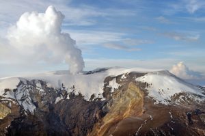
Alaska , Shishaldin :
Low-level unrest continues at Shishaldin Volcano, with occasional small volcanic earthquakes and weak seismic tremor being observed throughout the week. Sulfur dioxide emissions were detected on April 19 and 20 with satellite-based sensors, but no ash emissions or new deposits were observed in satellite data. Weak steam emissions were occasionally seen in webcam views when the summit was clear.
No changes at Shishaldin’s summit were observed in satellite radar data, but minor rock falls associated with collapse events from the unstable ground in and near the summit crater are possible. These events may generate very small clouds of fine-grained ash that dissipate quickly in the immediate vicinity of the summit.
No significant eruptive activity has occurred since November 2023.
Local seismic and infrasound sensors, web cameras, and a geodetic network are used to monitor Shishaldin Volcano. In addition to the local monitoring network, AVO uses nearby geophysical networks, regional infrasound and lighting data, and satellite images to monitor the volcano.
Source : AVO
Photo : Beesley, Nick.
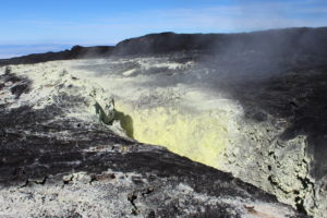
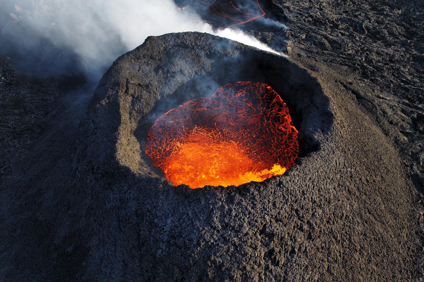
Iceland , Reykjanes Peninsula :
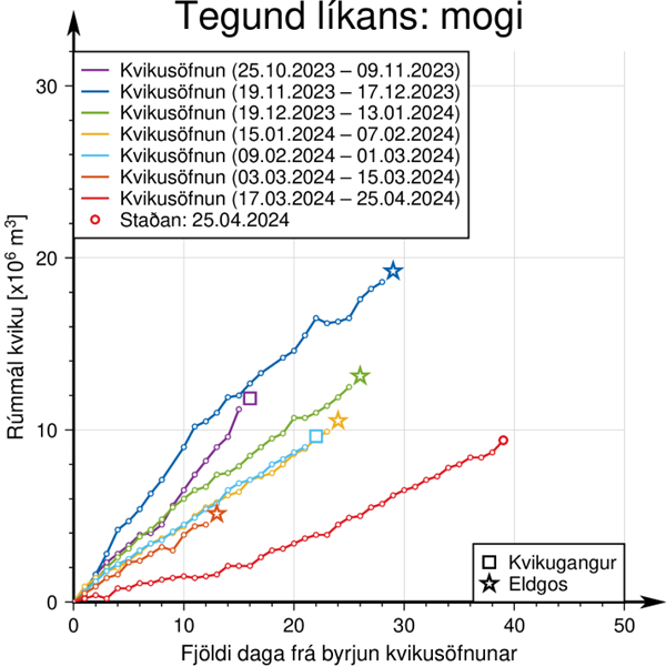
The accumulation of magma under Svartsengi since March 16 is approaching 10 million m3. Gas is still measured in the area and is clearly visible in a satellite image
Updated April 26 at 12:30 p.m.
The part of the lava bed close to the defenses to the east of Grindavík continues to thicken slowly
The uprising in Svartsengi continues at the same pace
If magma accumulation continues at a similar rate, there is a greater chance that the power of the eruption on the Sundhnúks crater series will increase significantly. There is still a risk of gas pollution in the region.
The Sundhnúk eruption continues and, as since April 5, a crater, a short distance east of Sundhnúk, is active. Lava flows a short distance south of the crater in an open lava river, but further away in closed channels. The part of the lava bed close to the defenses to the east of Grindavík continues to thicken slowly.
The uplift at Svartsengi continues apace as models predict that the amount of magma added to the Svartsengi magma chamber since the eruption began on March 16 is now approaching 10 million m3, as shown in the graph below. below. In previous events, magma flowed from Svartsengi when between 8 and 13 million m3 were added to the magma chamber since the last magma flow.
If magma accumulation continues at a similar rate, there is a greater chance that the power of the eruption on the Sundhnúks crater series will increase significantly.
New fissures could open in the area between Stóra-Skógfell and Hagafell and/or the existing fissure expand due to a sudden increase in lava flow which could be comparable to the initial phase of the last eruption volcanic in the region. This could happen with very little or no notice.
It is also possible that the flow of magma from the magma chamber beneath Svartsengi towards the Sundhnúks crater series gradually increases until there is a balance between the influx of magma into the magma chamber and the outflow towards the surface.
It is also possible that there will be a magma flow that will end with new fissures opening elsewhere than in the area between Stóra-Skógfell and Hagafell. This scenario is considered less likely than the others and would be accompanied by considerable seismic activity and earlier deformations than previous eruptions.
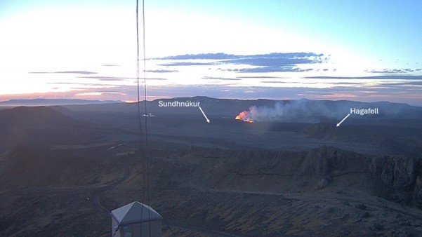
Image from the Norwegian Meteorological Agency webcam taken at 4:30 a.m. this morning shortly before sunrise. The camera is located at the top of Þorbirn and looks northeast towards the crater.
On Wednesday April 24, experts from the Norwegian Meteorological Agency carried out measurements of gas emissions from the eruption. It is estimated at 6-9 kg/s of SO2, but during the last measurement two weeks ago, on April 12, the gas emission was estimated at 10-18 kg/s. There is no evidence that it is getting gas emissions from the eruption. As the eruption continues, the SO2 flux can vary significantly from day to day (as shown in the Fagradalsfjall eruptions). There is still a risk of gas pollution in the area around the crater as well as in settlements on the Reykjanes Peninsula, and we advise residents in the area to monitor air quality and learn about the response to air pollution caused by the volcanic eruption.
Source : IMO
Photos : IMO , Hörður Kristleifsson.
Chile , Puyehue – Cordon Caulle :
Special Report on Volcanic Activity (REAV), Los Lagos region, Puyehue-Cordon Caulle volcanic complex, April 26, 2024, 4:00 p.m. local time (mainland Chile).
The National Service of Geology and Mines of Chile (Sernageomin) publishes the following PRELIMINARY information, obtained using the monitoring equipment of the National Volcanic Monitoring Network (RNVV), processed and analyzed at the Southern Andean Volcanological Observatory ( Ovdas):
According to the results obtained from the GNSS stations installed on the volcanic complex and the analysis of RADAR satellite images, an area of active inflation has been identified since 2012, the maximum of which is located approximately 6 km to the West-North-West of the emission center associated with the 2011 eruption. During the first months of the year, an increase in the accumulated vertical elevation speed was observed, reaching 42 cm, calculated at the GNSS station located 3 km from the maximum inflation zone.
In addition, since the middle of 2020 there has been an increase in the occurrence of volcano-tectonic (VT) and hybrid (HB) type seismicity, of high magnitude (ML>3.0), which is mainly associated with a superficial source located near the eruptive center of 2011. This in relation to other types of volcanic seismicity, especially associated with the dynamics of magmatic or hydrothermal fluids inside the volcanic conduits, while keeping low levels, both in quantity than in energy.
It should be mentioned that, although the monitoring parameters do not suggest a destabilization of the volcanic system, the area near the point of emission of the 2011 eruption presents gas emanations and superficial areas that record temperatures close to 90°C, consequence of the presence of a remnant magmatic body from the last eruption.
In summary, given the high value of deformation observed, which could be related to an overpressure of the system, the technical alert level is preventively raised to the YELLOW level.
Source et photo : Sernageomin.
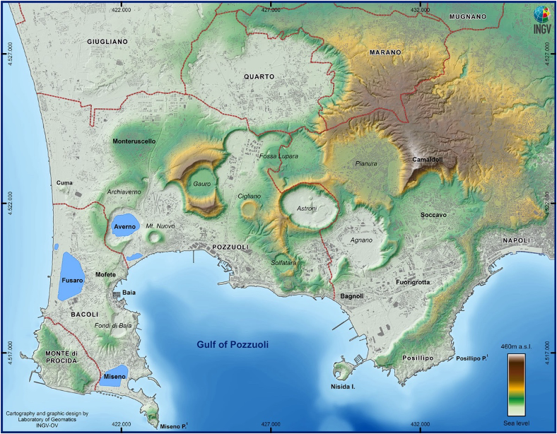
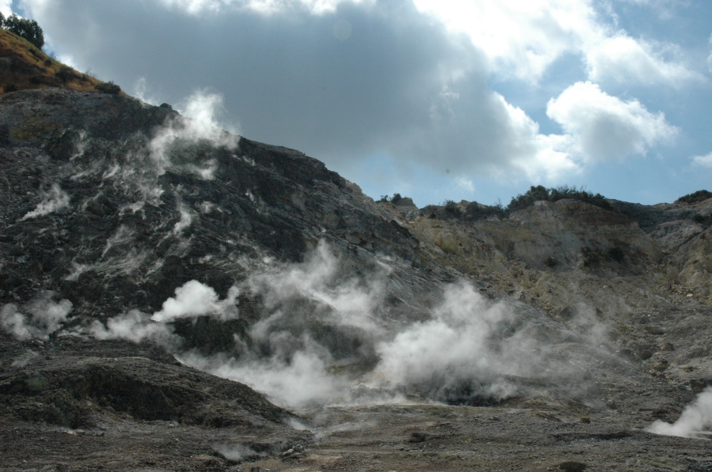
Italy , Campi Flegrei :
The Campi Flegrei are the largest active urbanized caldera in the heart of the European continent. Since 2005, it has been affected by the bradyseismic phenomenon which causes ground uplifts, earthquakes and fumarole emissions.
The caldera is monitored by a continuous multiparametric monitoring system. All the data provided by this system, at the moment, do not show evidence of an imminent volcanic eruption, much less of large proportions (Campania Volcano Monitoring Bulletins).
Volcanic risk mitigation actions rely on sharing correct information on the state of the volcano. Sharing can take many forms, such as the publication of data and bulletins on institutional websites, school meetings, meetings with the population exposed to risk, seminars, conferences, training for journalists, etc. The broad spectrum of these activities is constantly practiced by our Institute (we remember the last meeting with the Phlegrean population on April 11).
Faced with this commitment, what we observe in certain press articles relaunching a Swiss television documentary on the catastrophic effects of a future eruption at Campi Flegrei is therefore dissonant. This is information that is not data-driven and completely ignores all the important science and planning activities that have seen, and still see, scientists and civil protection working side by side to best manage the volcanic risk and its consequences, their knowledge and the risk of one of the most anthropized regions in the world.
Since 2012, hazard studies have made it possible to define the most likely eruptive occurrence scenarios in the area. And even if the scenario with the highest probability of occurrence is that of a small eruption (as happened for the Monte Nuovo eruption of 1538), as a reference scenario for the evaluation of potentially exposed areas to different phenomena during a future eruption, that relating to the most intense phase of a medium-scale eruption (like that which occurred at Astroni 4000 years ago) was chosen. For this scenario, an emergency plan was defined and areas exposed to different types of dangers were identified (pyroclastic flows for the red zone, ash falls for the yellow zone).
One of the characteristics of the Phlegrean caldera, and of calderas in general, is the difficulty of establishing a priori the area in which an eruptive vent will open, which could lead to greater uncertainty in the identification of areas potentially exposed to dangerous phenomena. To overcome this problem, areas subject to the impact of pyroclastic flows and ash falls were identified by considering all possible positions of a new eruptive vent.
 .
.
The probability that the next eruption will be of the Campanian Ignimbrite/Neapolitan Yellow Tuff type is very low. Additionally, for these very large-scale eruptions to occur, a huge amount of magma must enter the system. This would generate macroscopic signals that would not escape our surveillance system or the inhabitants of the area. Suffice it to say that before the last epoch of activity, during which 27 explosive eruptions occurred with a total volume of emitted magma of less than 3 km3, the area between Monte Nuovo and Pietra increased by approximately 50 mr.
During the two most devastating eruptions (Ignimbrite Campana and Neapolitan Yellow Tuff), tens to hundreds of cubic kilometers of magma were emitted in a single event.
How could these phenomena occur without significant and unnoticed precursors?
Source :Carlo Doglioni (Président de l’INGV), Francesca Bianco (Directrice du Département Volcans de l’INGV), Mauro A. Di Vito (Directeur de l’Observatoire Vésuvien de l’INGV)
Photos : INGV , Stanley-goodspeed.
Guatemala , Santiaguito :
Weather conditions: Clear weather.
Wind: South-East.
Precipitation: 3.4 mm.
Activity:
The Santiaguito Volcano Observatory reports activity in the Caliente dome, with continued low degassing, raising columns of water vapor and other magmatic gases to heights of 300 meters above the dome, as the wind moves towards the West and the South-West. During the night and early morning, explosions were observed and heard even at El Nuevo Palmar, as well as continued incandescence in the dome and on its flanks due to the constant extrusion of lava in blocks. Small and moderate explosions occur at a rate of 1 to 3 per hour, accompanied by low rumbling and outgassing noises, raising columns of water vapor and ash to heights of 700 meters above the dome.
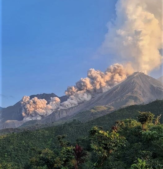
They cause the descent of pyroclastic flows over short distances, mainly towards the southwest, south and southeast flanks of the Caliente dome, piling the material in promontories on the aforementioned flanks. The wind blows to the West and South-West, so there may be weak ashfall in the area of San Marcos Palajunoj, Finca Pauwlonias and surrounding areas. In the afternoon and evening, the forecast rains could cause lahars to descend in different channels of the volcano. The activity remains at a high level, so it is possible that with the explosions or under the effect of gravity, part of the accumulated material collapses and that pyroclastic flows over long distances are generated towards the South- West, South and South-East.
Source : Insivumeh.
Photo : Edgar Cabrera / CONRED