April 28 , 2024.
Indonesia : Mérapi ,
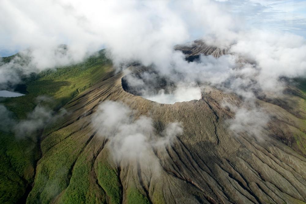
MOUNT MERAPI ACTIVITY REPORT April 19 – 25, 2024
OBSERVATION RESULT
Visual
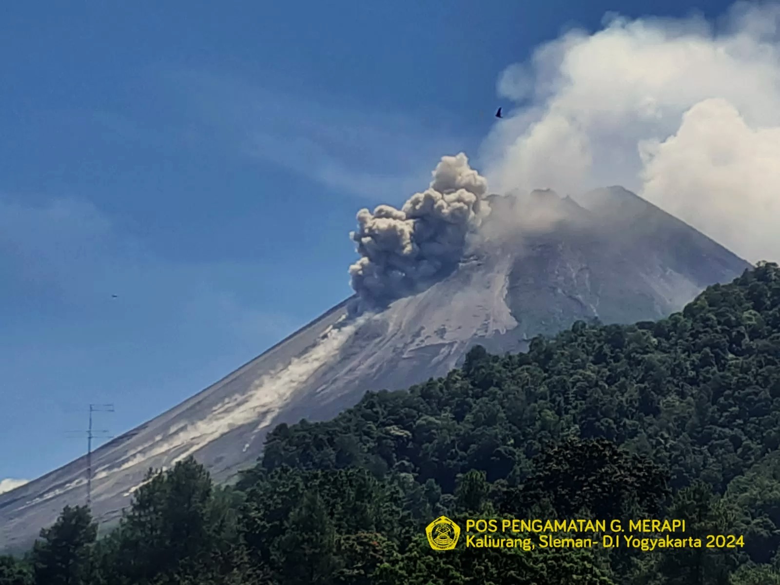
The weather around Mount Merapi is generally clear in the morning and night, while it is foggy from noon to evening. White smoke, thin to thick, low to moderate pressure and with a height of 425 m was observed from the observation post of Mount Merapi Babadan on April 22, 2024 at 05:20 WIB. This week, lava avalanches were observed 152 times towards the South-West (upstream of the Bebeng River) up to a maximum of 2,000 m. It was observed that the morphology of the southwest dome had changed due to lava avalanche activity. The morphology of the median dome is relatively constant. Based on the analysis of aerial photos dated March 30, 2024, the volume of the southwest dome was measured at 2,054,600 m3 and that of the middle at 2,358,200 m3.
Seismicity
This week, the seismicity of Mount Merapi recorded:
81 superficial volcanic earthquakes (VTB),
408 multi-phase (MP) earthquakes,
19 low frequency (LF) earthquakes,
538 avalanche earthquakes(RF),
15 tectonic earthquakes (TT).
The intensity of earthquakes this week is still quite high.
Deformation
The deformation of Mount Merapi monitored by EDM this week shows a shortening rate of 1.5 cm/day.
Rain and lahars
This week there was rain at Mount Merapi lookout post with a rain intensity of 83 mm/hour for 45 minutes at Kaliurang lookout post on April 19, 2024. No additional flow or lahar was reported in the rivers that have their source on Mount Merapi.
Conclusion
Based on the results of visual and instrumental observations, it was concluded that:
Volcanic activity at Mount Merapi is still quite high in the form of effusive eruptive activity. The activity state is set to the “STIAGA” level.
Source : BPPTKG
Photo : BPPTKG ( archive).
Colombia , Cumbal :
Weekly activity bulletin: Cumbal Volcanic Complex
Regarding the monitoring of the activity of the CUMBAL VOLCANIC COMPLEX (CVC), the MINISTRY OF MINES AND ENERGY, through the COLOMBIAN GEOLOGICAL SERVICE (SGC), reports that:
Between April 16 and 22, 2024, and compared to what was reported the previous week, seismicity presented a slight increase in its occurrence and energy. The predominance of seismicity associated with rock fracture remains. These earthquakes were located in a scattered manner in the upper part of the volcanic complex, at distances less than 2 km, with depths between 1 and 4 km from its summit (4,700 m above sea level) and with a maximum magnitude of 0.6.
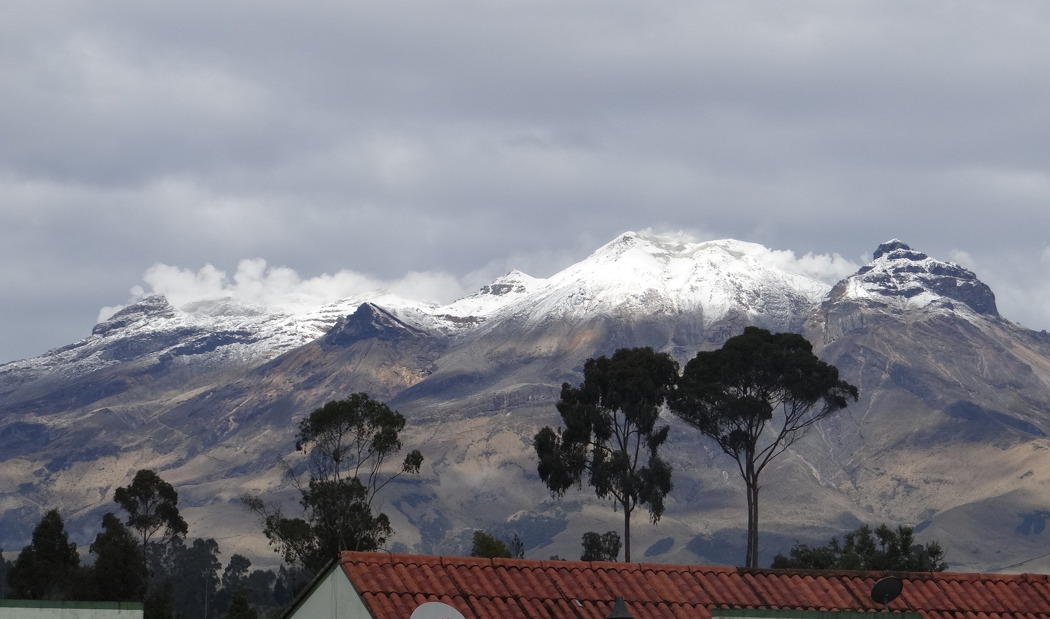
Gas emissions were recorded in the El Verde fumarole fields, northeast of the CVC; and Los Rastrojos, Las Bandas and Boca Vieja, southwest of the CVC, with white columns, dispersion and variable height depending on the wind direction. No significant variation was observed in the other geophysical and geochemical parameters of volcanic monitoring.
Volcanic activity remains in a YELLOW ALERT state: Active volcano with changes in the behavior of the base level of monitored parameters and other manifestations.
Source et photo : SGC
Hawaii , Kilauea :
Saturday, April 27, 2024, 9:14 AM HST (Saturday, April 27, 2024, 19:14 UTC)
19°25’16 » N 155°17’13 » W,
Summit Elevation 4091 ft (1247 m)
Current Volcano Alert Level: ADVISORY
Current Aviation Color Code: YELLOW
Activity Summary:
Kīlauea volcano is not erupting. Increased seismicity over the past month indicates heightened activity beneath the summit and upper East Rift Zone of Kīlauea. Updates will be provided daily while at a heightened state of unrest.
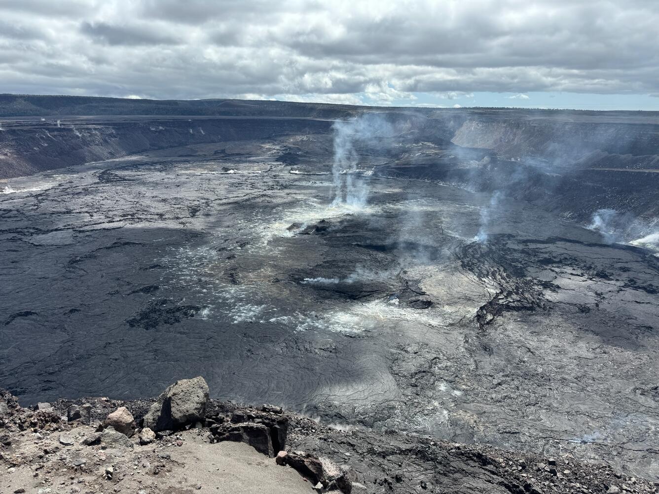
Summit Observations:
Earthquake activity has increased over the past month beneath the summit of Kīlauea and south of the caldera. Activity has alternated between typical shallow, 0.5-2.5 miles (1-4 km) earthquakes beneath the south caldera region and 3-6 miles (5-10 km) deep earthquakes directly beneath Kīlauea caldera. The number of deep earthquakes beneath Kīlauea caldera has diminished over the past several days. Most of these earthquakes have been smaller than magnitude-2. Kīlaueaʻs summit remains inflated. Overall ground deformation rates remain low, with ongoing inflation of the summit and uplift south of the caldera. Tiltmeters near Sand Hill and Uēkahuna showed no significant changes over the past day. Sulfur dioxide (SO2) gas emission rates remain low. An SO2 emission rate of approximately 52 tonnes per day was recorded on April 23.
Rift Zone Observations:
An increasing number of shallow earthquakes, 0.5-2.5 miles (1-4 km) deep, have been observed beneath the upper East Rift Zone over the past several days. Seismicity beneath the upper East Rift Zone increased significantly overnight, with more than 100 earthquakes detected over the past 8 hours. Most of these earthquakes have been smaller than magnitude-2 and located between Puhimau Crater and Hilina Pali road. Seismicity in Kīlauea’s Southwest Rift Zone remains low overall. No unusual activity has been noted along the middle and lower sections of Kīlauea’s East Rift Zone. Measurements from continuous gas monitoring stations downwind of Puʻuʻōʻō in the middle East Rift Zone—the site of 1983–2018 eruptive activity—continue to be below detection limits for SO2, indicating that SO2 emissions Puʻuʻōʻō are negligible.
Source : HVO.
Photo : USGS / M. Patrick.
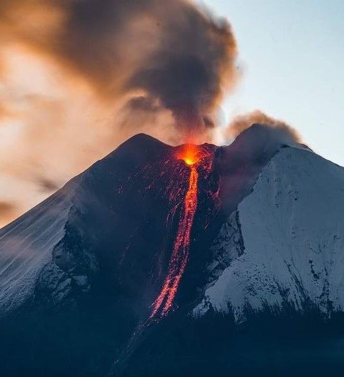
Ecuador , Sangay :
DAILY REPORT ON THE STATE OF THE SANGAY VOLCANO, Saturday April 27, 2024.
Information Geophysical Institute – EPN.
Surface activity level: High, Surface trend: Descending
Internal Activity Level: High, Internal Trend: Descending
Seismicity: From April 26, 2024, 11:00 a.m. to April 27, 2024, 11:00 a.m.:
The number of seismic events recorded at the reference station over the past 24 hours is shown below. The level of seismic activity of the volcano remains high.
Explosion Event (EXP): 388
Precipitation/Lahars:
Yesterday afternoon, at the time of writing this report, rains were recorded in the volcano area without generating mudflows and debris. *In the event of heavy rains, these could remobilize the accumulated materials, generating mud and debris flows which would flow down the sides of the volcano and flow into adjacent rivers.*
Emissions/ash column:
Over the past 24 hours, thanks to the surveillance camera system and the GOES-16 satellite system, gas and ash emissions have been recorded at heights greater than 2000 meters above the level of the crater in the North direction. West. In connection with this activity, the VAAC agency in Washington issued 2 emissions reports, both having a height of 600 meters above the level of the crater and which were directed towards the West.
Gas:
The Mounts satellite system recorded 357.2 tonnes of sulfur dioxide (SO2) measured at 2:14 p.m. yesterday.
Other monitoring parameters:
Over the past 24 hours, the FIRMS satellite system recorded 47 thermal anomalies, while MIROVA-MODIS and MIROVA-VIIRS detected 2 and 3 anomalies, respectively.
Observation:
Yesterday afternoon the volcano remained mostly cloudy. At night, thanks to the surveillance camera system, several explosions were observed accompanied by the descent of incandescent materials up to 1,800 meters below the level of the crater. Since this morning the volcano remains cloudy.
Alert level: yellow
Source : IGEPN.
Photo : AlexBoasphoto
Costa – Rica , Poas / Rincon de la Vieja :
Poas Volcano
Latitude: 10.2
Longitude: -84,233
Altitude: 2,687 meters
Activity observed:
In general, the trend in seismic activity and degassing is downward. This is also reflected in eruptive activity. No significant ash content is observed in the plume. The tremor remained very weak, with dominant frequencies around 1.7 Hz. An increase in the number of long period (LP) events is observed. For several days, the contraction has stopped and no vertical deformation is observed. SO2 concentrations at the lookout reached a maximum value of 3.1 ppm this week, reflecting a decrease from the maximum values recorded over the past three weeks (8.3 ppm was recorded on March 23).
Activity Level: Warning (2)
Rincón de la Vieja Volcano
Latitude: 10.83
Longitude:-85.324
Altitude: 1,916 meters
Activity observed:
Since yesterday, an increase in tremors can be observed with a frequency range of 0.7 to 6 Hz. This tremor is also accompanied by long period (LP) type events which reach hundreds per day. These seismic tremor energy levels are the highest achieved compared to the period 2019 – 2024. Geodetic measurements continue to show an extension of the base of the volcano. The SO2 flow has been increasing since April 21 until yesterday, where it increased from 77 ± 44 to 493 ± 162 t/d respectively. The CO2/SO2 ratio shows average values of 1.3 ± 0.8. The H2S/SO2 ratio continues to show values close to 0.2 as in previous days. These gas compositions and SO2 fluxes are typical of emissions from a relatively shallow magma source without significant influence from a hydrothermal system.
Activity level: Attention (3)
Source : Ovsicori.
Photos : Ovsicori