September 09 , 2023.
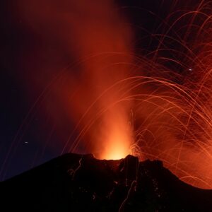
Alaska , Great Sitkin :
52°4’35 » N 176°6’39 » W,
Summit Elevation 5709 ft (1740 m)
Current Volcano Alert Level: WATCH
Current Aviation Color Code: ORANGE
Slow eruption of lava is continuing at Great Sitkin Volcano. Weakly elevated surface temperatures were observed in satellite images and earthquake activity remained slightly elevated this week. Typical steaming from the vent region of the lava flow was observed in satellite images on several days. AVO geology crews spent about three hours working on the active flows on September 3 and report that the flows are warm and steaming and moving at about 1 meter every 3 to 4 days.
The current lava flow at Great Sitkin Volcano began erupting in July 2021. No explosive events have occurred since a single event in May 2021.
The volcano is monitored by local seismic, geodetic, and infrasound sensors, web cameras, regional infrasound and lightning networks, and satellite data.
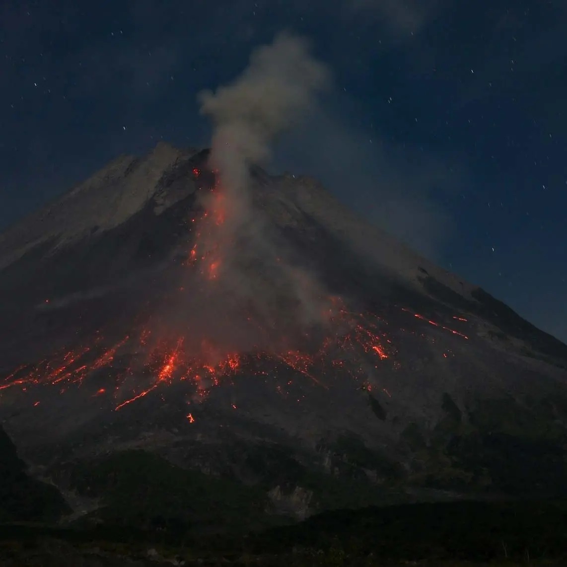
Oblique view of Great Sitkin Volcano looking northeast at the active lava flows from the crater. Lava flows spilling out of the crater on formed in 2021 and 2022. Photo taken on September 1, 2023 during a helicopter overflight by AVO geologists.
Great Sitkin Volcano is a basaltic andesite volcano that occupies most of the northern half of Great Sitkin Island, a member of the Andreanof Islands group in the central Aleutian Islands. It is located 26 miles (43 km) east of the community of Adak. The volcano is a composite structure consisting of an older dissected volcano and a younger parasitic cone with a ~1 mile (1.5 km)-diameter summit crater. A steep-sided lava dome, emplaced during the 1974 eruption, occupies the center of the crater. That eruption produced at least one ash cloud that likely exceeded an altitude of 25,000 ft (7.6 km) above sea level. A poorly documented eruption occurred in 1945, also producing a lava dome that was partially destroyed in the 1974 eruption. Within the past 280 years a large explosive eruption produced pyroclastic flows that partially filled the Glacier Creek valley on the southwest flank.
Source : AVO
Photo : Loewen, Matt
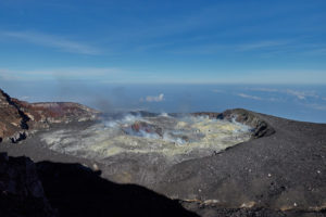
Indonesia , Merapi :
Report on the activity of Mount Merapi from September 1, 2023 to September 7, Published on September 8, 2023.
OBSERVATION RESULTS
Visual
The weather around Mount Merapi is generally sunny in the morning and afternoon, while the evening is foggy. White smoke, fine to thick, low to medium pressure and 100 m high was observed from the observation post of Mount Merapi of Pengamatan on September 6, 2023 at 05:00.
This week, lava avalanches were observed 154 times towards the South and South-West, including 5 times upstream of the Boyong River up to a maximum of 1,500 m, 146 times upstream of the Bebeng River up to at 2000 m and 3 times upstream of the Senowo River up to a maximum of 1500 m. The sound of avalanches was heard 21 times from the Babadan post with low to moderate intensity.
The morphology of the southwest dome underwent changes due to growth activity and lava avalanches, while no significant changes were observed for the central dome. Based on aerial photo analysis on August 30, 2023, the measured volume of the southwest dome was 2,858,600 m3 and the central dome was 2,355,100 m3.
Seismicity
This week, the seismicity of Mount Merapi showed:
96 shallow volcanic earthquakes (VTB),
2253 multi-phase (MP) earthquakes,
11 low frequency (LF) earthquakes,
878 avalanche earthquakes (RF)
6 tectonic earthquakes (TT).
The intensity of seismicity this week is lower than last week, but the number of earthquakes is still quite high.
Deformation
The deformation of Mount Merapi that was monitored using EDM this week showed a shortening of steepening distance of 1.6 cm/day.
Rain and lahars:
There was no rain this week at Pengamatan’s Mount Merapi lookout post. There have been no reports of additional flows or lahars from rivers flowing down from Mount Merapi.
Conclusion
Based on the results of visual and instrumental observations, it is concluded that:
-Mount Merapi’s volcanic activity is still quite high in the form of effusive eruption activity. The activity status is defined at the “SIAGA” level.
The current danger potential is in the form of lava avalanches and hot clouds in the South-South-West sector including the Boyong river for a maximum of 5 km, the Bedog, Krasak, Bebeng rivers for a maximum of 7 km. In the South-East sector, it includes the Woro river for a maximum of 3 km and the Gendol river for 5 km. While the ejection of volcanic material in the event of an explosive eruption can reach a radius of 3 km from the summit.
Source : BPPTKG
Photo : Andi volcanist .
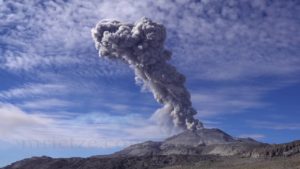
Philippines , Mayon :
MAYON VOLCANO BULLETIN 09 September 2023 8:00 AM
In the past 24-hour period, the Mayon Volcano Network recorded ten (10) volcanic earthquakes, one hundred twenty-eight (128) rockfall events, and two (2) PDC events. The lava flows have maintained their advances to approximately 3.4 kilometers in Bonga (southeastern), 2.8 kilometers in Mi-isi (south), and 1.1 kilometers in Basud (eastern) gullies. Rockfall and pyroclastic density currents or PDCs generated by collapses of the lava flow margins as well as of the summit dome deposited debris still within four (4) kilometers of the crater. Volcanic sulfur dioxide (SO2) emission averaged 2,175 tonnes/day on 08 September 2023.
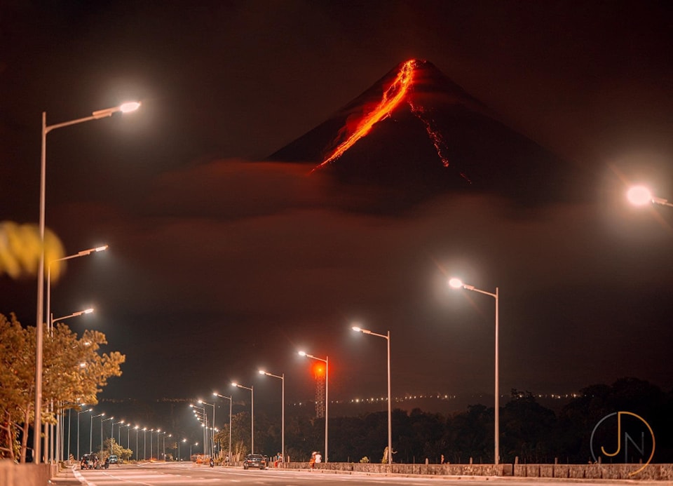
Short-term observations from electronic tilt and GPS monitoring indicate pronounced inflation of southeastern middle slopes since the beginning of August 2023. Longer-term ground deformation parameters from EDM, precise leveling, continuous GPS, and electronic tilt monitoring indicate that Mayon is still generally inflated relative to baseline levels.
Alert Level 3 is maintained over Mayon Volcano, which means that it is currently in a relatively high level of unrest and hazardous eruption within weeks or even days could still be possible.
Source : Phivolcs
Photo : JPN
Chile , Laguna del Maule :
Seismology
The seismological activity of the period was characterized by the recording of:
545 seismic events of type VT, associated with the fracturing of rocks (Volcano-Tectonics). The most energetic earthquake presented a Local Magnitude (ML) value equal to 2.8, located 9.8 km south-southwest of the center of the lagoon, at a depth of 7.8 km compared to the average height of the lagoon.
5 LP type seismic events, associated with fluid dynamics inside the volcanic system (Long Period). The size of the largest earthquake evaluated from the Reduced Displacement (RD) parameter was equal to 27 cm2.
Fluid geochemistry
No anomalies have been reported in the emissions of sulfur dioxide (SO2) into the atmosphere in the area near the volcanic complex, according to data published by the Troposphere Monitoring Instrument (TROPOMI) and the Tropospheric Monitoring Instrument (TROPOMI). ozone monitoring (IMO).
Geodesy
The geodetic activity of the period was characterized by:
– Monitoring lines with average rates similar to historical values, observed in the volcanic complex, adjusting a maximum of 1.55 cm/month.
– Horizontal strain rates similar to previous periods, with some minor variations.
– Thanks to satellite radar interferometry, no signal associated with deformation due to the heavy presence of snow in the area is detected.
Satellite geomorphological analysis
According to the observation of Planet Scope and Sentinel 2-L2A satellite images, no morphological change linked to volcanic activity has been identified, significant snow cover is observed.
During this period, the record of volcano-tectonic seismicity remains, with an energy lower than that of previous periods. The process of volcanic deformation continues
,active , with elevation rates similar to those historically recorded according to geodetic network data. On the surface, no change associated with volcanic activity is observed.
From the above, we deduce that the volcanic system remains above its base threshold, therefore its technical alert level is maintained in yellow and within a possible impact radius of 2 km around the abnormal CO2 zone , detected in previous years in the southwestern sector of the Cajón de Troncoso lagoon.
YELLOW TECHNICAL ALERT: Changes in the behavior of volcanic activity.
Source : Sernageomin.
Photo : OAVV
Costa Rica , Rincon de la Vieja :
Latitude: 10.83
Longitude:-85.324
Altitude: 1,916 meters above sea level
Observed activity:
On 07/09, a small eruption was recorded at 6:10 am, with a plume of water vapor and gas that did not rise more than 500 meters above the active crater.
Over the past 24 hours, one small exhalation and two small eruptions have been recorded, the last being at 2:48 a.m. The background tremor appears variable in amplitude and frequency. At the time of writing this report, low frequencies dominate in the background tremor (0.8 – 2 Hz).
The appearance of signals associated with tectonic processes within the massif (VT) continues, both at the summit and at the base of the volcano. Geodetic measurements detect an extension of the base of the volcanic massif. Inflation present at the peak over the last 2 weeks has reduced. The fumaroles inside the crater remain slightly active. Volcano-tectonic earthquakes continue to be recorded near the summit, but with a much weaker magnitude and in less quantity than in previous days. The flows of magmatic gases remain stable.
Environmental conditions:
The wind blows from the southwest and the summit remains cloudy.
Activity Level: Attention (3)
Source : Ovsicori
Photo : Chris Allen