October 20 , 2020.
Peru , Sabancaya :
Analysis period: October 12-18, 2020, Arequipa, October 19, 2020.
Alert level: ORANGE
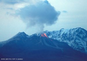
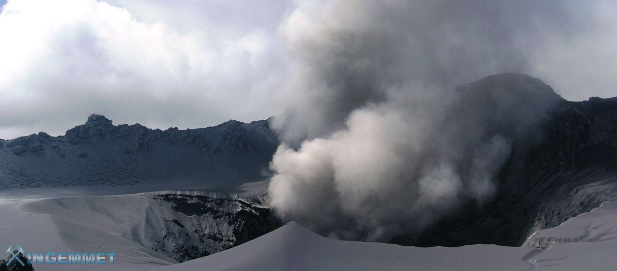
The Geophysical Institute of Peru (IGP) reports that the eruptive activity of the Sabancaya volcano remains at moderate levels; that is to say with the continuous recording of explosions with columns of ash and gas up to 3 km altitude above the summit of the volcano and their resulting dispersion. Therefore, for the following days, no significant change is expected in the eruptive activity.
The IGP recorded the occurrence of 1858 volcanic earthquakes associated with the circulation of magmatic fluids under the Sabancaya. An average of 34 explosions was recorded daily of low to medium intensity. During this period, Volcano-Tectonic (VT) earthquakes were located mainly in the North-West and East of Sabancaya, with magnitudes between M2.0 and M2.8. The most representative earthquake (M2.8) was recorded on October 18 at 1:10 p.m. local time, 10 km east of Sabancaya and 12 km deep.
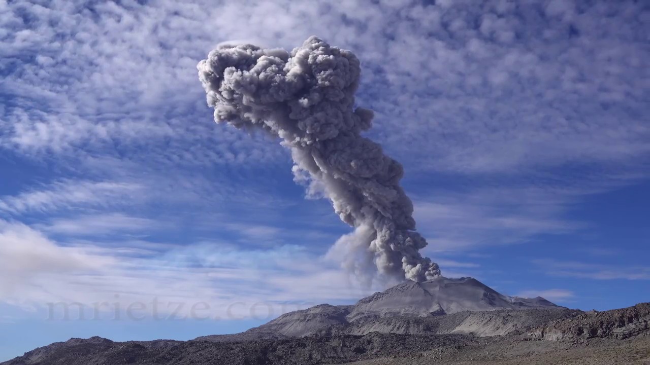
Monitoring the deformation of the volcanic structure, using GNSS techniques (processed with fast orbits), shows that since October 11, there has been a slight process of deflation (contraction) of the south-eastern flank of the Sabancaya. The visual surveillance made it possible to identify columns of gas and ash up to 3 km altitude above the summit of the volcano, which were scattered towards the North-East, North-West, North, South-East sectors, Southwest and West of Sabancaya. Ash falls were reported in the districts of Huanca and Madrigal. Satellite monitoring has identified the presence of 7 thermal anomalies with values of 2 MW and 25 MW, associated with the presence of a lava body (being destroyed) on the surface of the volcano’s crater.
RECOMMENDATIONS
• Maintain the orange volcanic alert level.
• Do not approach within a radius of less than 12 km around the crater.
Source : IGP.
Photo : Martin Rietze .
Peru , Ubinas :
Analysis period: October 12-18, 2020 Arequipa, October 19, 2020.
Alert level: YELLOW
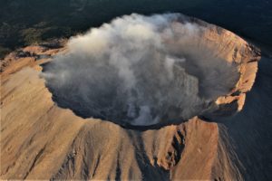
The Geophysical Institute of Peru (IGP) reports that the Ubinas volcano (Moquegua region) continues to record a slight increase in its seismic activity during the analysis period, which is linked to the circulation of fluids (gas) at the inside the volcano; therefore, it is suggested that the authorities and the public pay attention to the bulletins published by the IGP.
During the analysis period, the occurrence of 24 volcano-tectonic (VT) earthquakes with a magnitude less than M1.3 was identified, associated with rock breaking processes that occur at the inside the volcano. On average, 3 earthquakes were recorded per day. Likewise, 9 seismic signals were recorded, associated with the movements of volcanic fluids (gas). Among these, 3 seismic events of the « tornillos » type were recorded.
Surveillance cameras recorded columns of whitish gas (mainly water vapor) which reached heights of up to 200 m above the summit of the volcano. These emissions dispersed towards the eastern sector of the volcano.
Monitoring of the deformation of the volcanic structure, using GNSS equipment (processed with fast orbits), does not show significant changes. Satellite monitoring, carried out with the help of SENTINEL, OMI-NASA (SO2 gas) and MIROVA (thermal anomalies), does not record any anomalies.
RECOMMENDATIONS
• Do not approach within a radius of less than 4 km around the crater.
Source : IGP.
Photo : ingemmet 2006
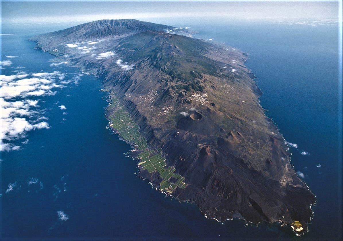
Canaries , La Palma :
Update on the seismic swarm of La Palma.
From 8:01 p.m. (Canary Island time) last Saturday, October 17, 2020 to 4:01 a.m. (Canary Island time) today, October 19, 2020, the Canary Islands seismic network operated by the Canary Islands Volcanological Institute (INVOLCAN) detected 28 low magnitude seismic events (Mmax = 1.4) on the island of La Palma. Of these 28 seismic events, 21 were located and their hypocenters fell in the area of the Cumbre Vieja volcano at depths of about 5 km.
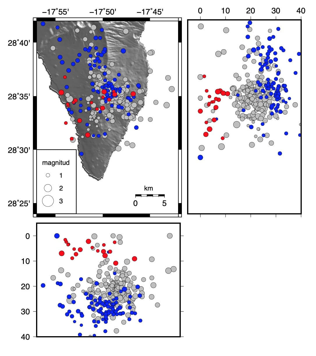
The figure shows the localized seismic events of the October 18 swarm in red, those of the October 8-10 swarm in blue, and those of the October 2017, February 2018 and July 2020 swarms in gray.
This seismic activity on La Palma does not represent any danger.
Some people ask us if there is a high probability of an eruption in Cumbre Vieja in the short term due to the recent seismic swarms recorded on the island of Palma.
With the data and knowledge we have so far, we can state that the probability of an eruption in Cumbre Vieja in the short term is very low.
Volcanic systems active throughout their geological history experience several eruptive cycles and each of them is characterized by 4 phases: inter-eruptive, pre-eruptive, eruptive and post-eruptive; return after this to the inter-eruptive phase.
In the case of the Cumbre Vieja volcano, this active volcanic system has experienced 7 eruptive cycles over the past 550 years. At Cumbre Vieja, we know that 7 of the 16 historic eruptions that have occurred in the Canary Islands have occurred. Since the end of the post-eruptive phase linked to the eruption of Teneguía in 1971, the Cumbre Vieja volcano has been in an inter-eruptive phase; phase he has enjoyed for over 48 years.
This situation has not changed for Cumbre Vieja despite recent seismic swarms in October 2017, February 2018, July 2020 and October 2020 as another set of criteria must be met to establish that Cumbre Vieja passes from the inter-eruptive phase. in the pre-eruptive phase. Therefore, considering the 7 eruptive cycles recorded in Cumbre Vieja over the past 550 years, one could argue that the probability of an eruption in Cumbre Vieja is 1.3% for a 1 year window, from 6.2 % for 5 years, 11.9% for 10 years, 47.1% for 50 years and 72.0% for 100 years. On the other hand, it is obvious that these percentages would increase in the event that the Cumbre Vieja volcano goes from the inter-eruptive phase, in which it is now, to a clear pre-eruptive phase.
Source : Involcan .
Photo : Sergio Socorro.
La Réunion , Piton de la Fournaise :
Alert level: Vigilance
Seismology
– Number of landslides on 19-10-2020: 9
Areas affected by landslides:
Summit cone
Enclosure

– Number of volcano-tectonic earthquakes (VT) of 19-10-2020: 4
Zone affected by VT:
Summit cone
– Volcano-tectonic earthquake of greater magnitude of 19-10-2020: Duration: 3.48 s, Magnitude of duration: 0.21.
Deformations
– The GPS of the summit area record inflation, witnessing the pressurization of a surface source.
– Far-field GPS record an inflation, witness the pressurization of a deep source.
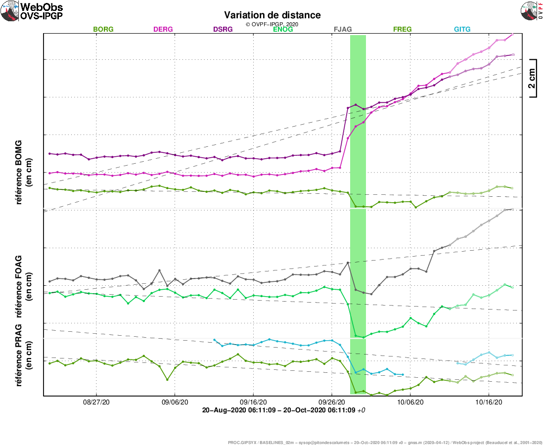
Illustration of the deformation over 2 months. The baselines (variation of distance between two GPS receivers) crossing the Piton de la Fournaise building, at the top (top), the base of the terminal cone (in the middle) and in the far field (bottom) are shown here. ) (see location on the associated maps). A rise is synonymous with elongation and therefore swelling of the volcano; conversely, a decrease is synonymous with contraction and therefore deflation of the volcano. The possible periods colored in light pink correspond to the eruptions.
Geochemistry
SO2 emissions at the top of the volcano: below or close to the detection threshold.
CO2 emissions from the ground: stable or increasing at all stations.
Source : OVPF .
Photo : Imaz Press