July 27 , 2020.
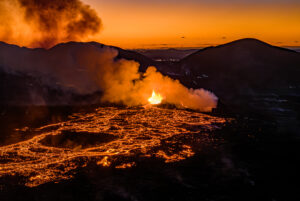
Chile , Villarica :
Region Del Ñuble, Volcan Villarica, July 25, 2020, 19:50 Local time (Continental Chile).
The National Geological and Mining Service of Chile (Sernageomin) publishes the following PRELIMINARY information, obtained by the monitoring teams of the National Volcanic Monitoring Network (RNVV), processed and analyzed at the Volcanological Observatory of the Sur Andes (Ovdas):
At 6:07 p.m. this Saturday, July 25, at 6:07 p.m. local time (10:07 p.m. UTC), the monitoring stations installed in the vicinity of the Villarica volcano recorded a long-period earthquake (LP), associated with a moderate explosion at the level of the active crater, with a reduced displacement value equal to 73 cm2, accompanied by an infrasound signal equal to 14.7 pascals reduced to 1 kilometer. It should be noted that during the last period no event of this nature was recorded.
The meteorological conditions present in the sector did not allow the surface activity to be recorded through the cameras.
Meanwhile, at the time of publication of this report, the seismicity is not registering significant changes and is continuing at levels similar to those recorded before the reported event. There are no reports from the communities on a possible feeling of the event.
Finally, the technical alert level is maintained at YELLOW level.
Source : Sernageomin .
Photo: Franco Vera.
Mexico , Popocatepetl :
July 26, 11:00 a.m. (July 26, 4:00 p.m. GMT).
During the last 24 hours, according to the monitoring system of the Popocatépetl volcano, 107 exhalations have been identified, accompanied by volcanic gases and sometimes small amounts of ash. In addition, 1095 minutes of tremor were counted, of which 550 minutes of low amplitude and 545 minutes of medium amplitude, accompanied by an emission of steam, gas and a slight amount of ash, with heights of up to 1500 m, scattered in the West-North-West direction.
During the morning, an episode of tremor occurred accompanied by the expulsion of fragments a short distance from the crater and a column of gas and ash with a height of about 1300 m in the North- Where is . At the time of writing, there is no information on ash fall in nearby towns. Additionally, for most of the night, a nocturnal glow was observed over the crater.
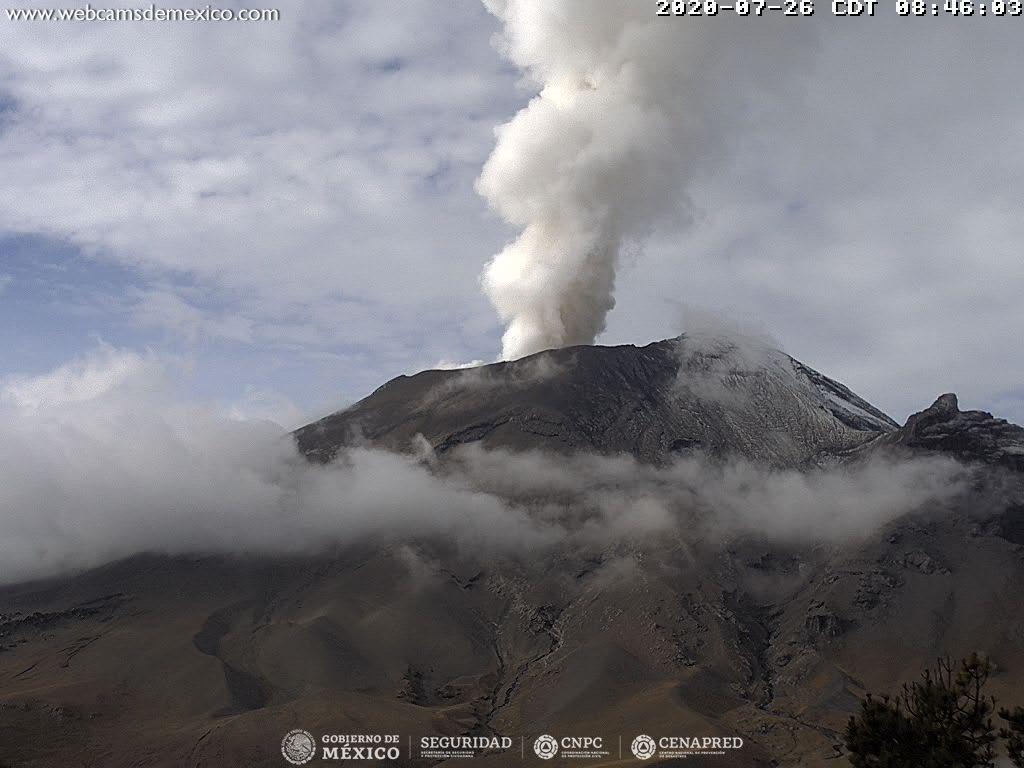
From the morning and at this moment, a constant emission of water vapor is observed, oriented to the North-West.
CENAPRED urges NOT TO APPROACH the volcano and especially the crater, because of the danger involved by the fall of ballistic fragments and, in the event of heavy rains, to move away from the bottom of the ravines because of the danger of mudslides and debris.
The Popocatépetl volcanic alert signal light is in YELLOW PHASE 2.
Source : Cenapred .
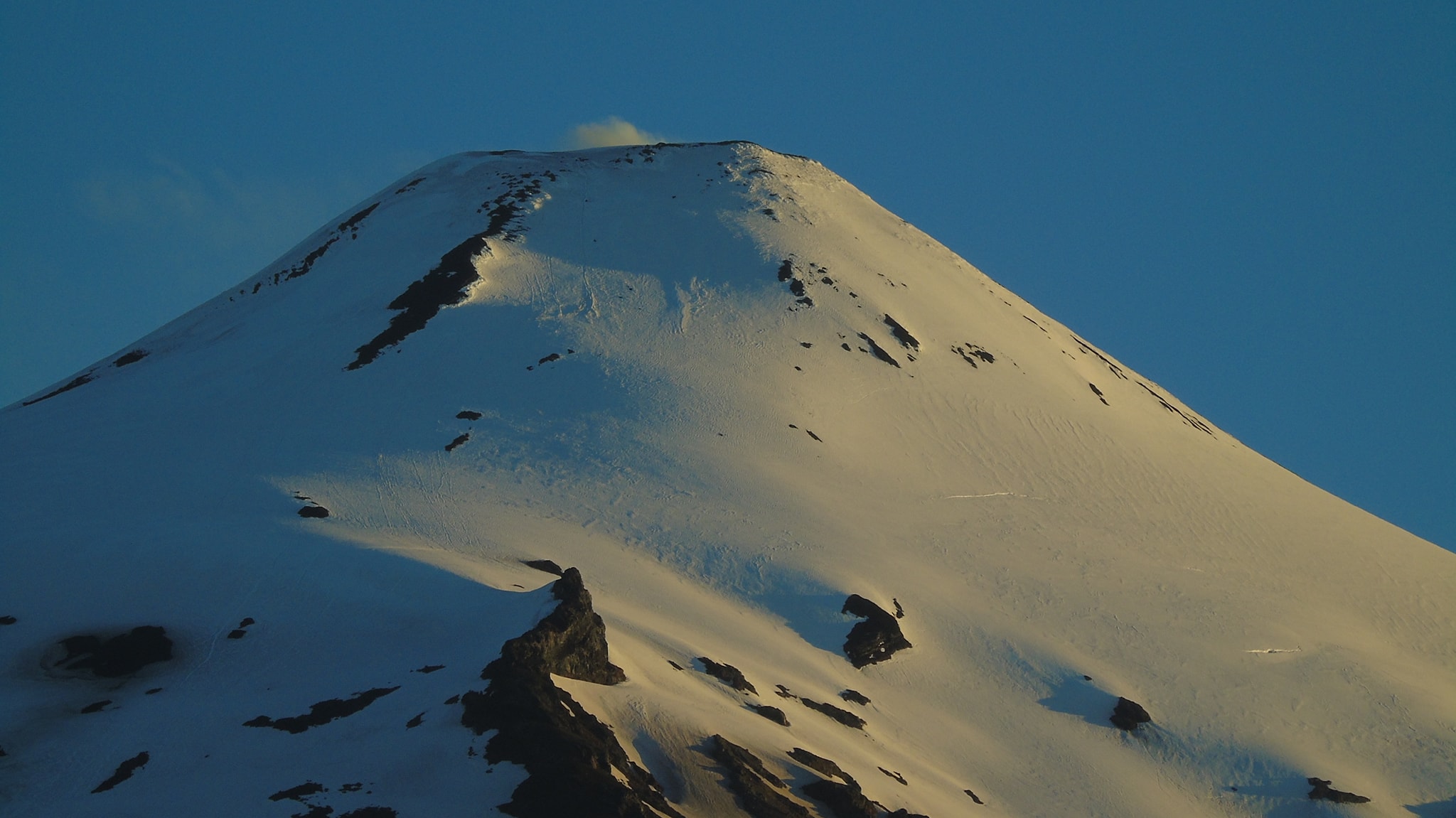
Alaska , Cleveland :
52°49’20 » N 169°56’42 » W,
Summit Elevation 5676 ft (1730 m)
Current Volcano Alert Level: ADVISORY
Current Aviation Color Code: YELLOW
Weakly elevated surface temperatures were observed in satellite imagery and web camera images showed no unusual activity over the past day. No activity was detected on local or regional geophysical networks over the past day.
Episodes of lava effusion and explosions can occur without advance warning. Explosions from Cleveland are normally short duration and only present a hazard to aviation in the immediate vicinity of the volcano. Larger explosions that present a more widespread hazard to aviation are possible, but are less likely and occur less frequently.
Cleveland volcano is monitored by only two seismic stations, which restricts AVO’s ability to detect precursory unrest that may lead to an explosive eruption. Rapid detection of an ash-producing eruption may be possible using a combination of seismic, infrasound, lightning, and satellite data.
Source : AVO.
Photo : avec Carlite Island , Kaufman, Max.
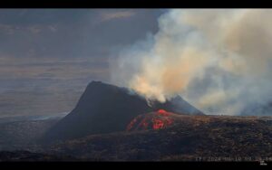
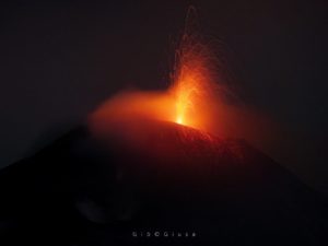
Indonesia , Semeru :
Level of activity at level II (WASPADA). The Semeru volcano (3,676 m above sea level) is experiencing a continuous eruption. Explosive and effusive eruptions, causing lava flows towards the south and south-eastern slopes, as well as projections of incandescent rocks around the summit crater are observed.
The volcano is clearly visible until it is covered in fog. The smoke from the main crater is not observed. The weather is sunny / cloudy, the winds weak to the South, South-West and North-East.
According to the seismographs of July 26, 2020, it was recorded:
46 emission / eruption earthquakes
2 avalanche earthquakes
1 distant tectonic earthquake.

Recommendation:
The community must not carry out activities within a radius of 1 km and in the area up to 4 km in the sector of the South-South-East slopes of the active crater which is the active opening area of the G. crater. Semeru (Jongring Seloko) as a hot cloud slide channel.
Be aware of the presence of the lava dome in the Seloko Jongring crater.
VOLCANO OBSERVATORY NOTICE FOR AVIATION – VONA.
Issued : July 25 , 2020
Volcano : Semeru (263300)
Current Aviation Colour Code : ORANGE
Previous Aviation Colour Code : orange
Source : Semeru Volcano Observatory
Notice Number : 2020SMR80
Volcano Location : S 08 deg 06 min 29 sec E 112 deg 55 min 12 sec
Area : East java, Indonesia
Summit Elevation : 11763 FT (3676 M)
Volcanic Activity Summary :
Eruption with volcanic ash cloud at 22h31 UTC (05h31 local).
Volcanic Cloud Height :
Best estimate of ash-cloud top is around 13363 FT (4176 M) above sea level, may be higher than what can be observed clearly. Source of height data: ground observer.
Other Volcanic Cloud Information :
Ash cloud moving to south
Remarks :
Seismic activity is characterized by eruption, avalanche and gas emission earthquakes
Source : PVMBG , Magma Indonésie .
Photos : Auteur inconnu , Cucuk Donartono/Koz/pd/12