May 23 , 2023.
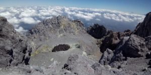
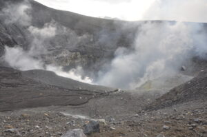
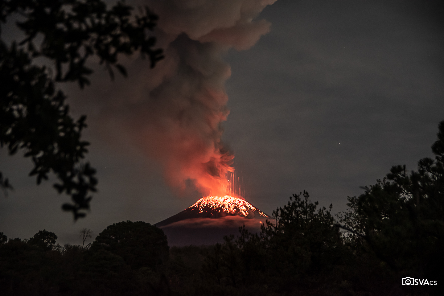
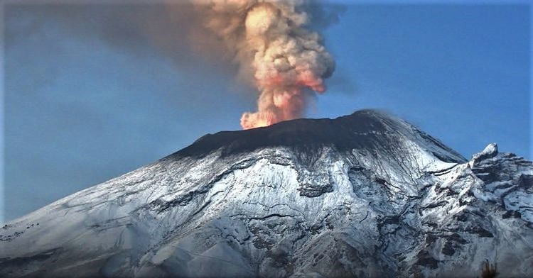
Mexico , Popocatepetl :
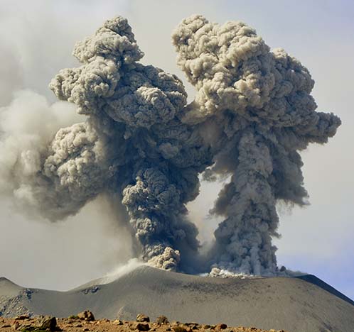
May 22, 11:00 a.m. (May 22, 5:00 p.m. GMT)
During the 81st meeting of the scientific advisory committee of the Popocatépetl volcano held on May 20 and based on the analysis of the information available in recent days, it was recommended to change the phase of the volcanic alert traffic light from the phase yellow 2 to the yellow 3 phase, which is a preventive measure against the observed changes.
During the last 24 hours, according to the monitoring systems of the Popocatépetl volcano, 5 exhalations accompanied by water vapor, volcanic gases and ash have been detected. In addition, 1,389 minutes of low to large amplitude high frequency tremors were recorded, associated with the continuous emission of gas, water vapor and ash, as well as some occasions of expulsion of incandescent materials. a short distance from the volcano. Also, two moderate explosions were recorded, the first occurred yesterday at 1:55 p.m., and the second today at 5:33 a.m. local time.
CENACOM (National Center for Communication and Civil Protection Operations) reported during this period ash falls in the municipalities of San Andrés Cholula, San Pedro Cholula, Cuautlancingo, Amozoc, Zacatlán, Tetela de Ocampo, San Nicolás de los Ranchos, Palmar de Bravo, Tepeaca, in Izúcar de Matamoros, Epatlán, Teopantlán, locality of Xochitepec (municipality of Jolalpan), Tlapacoy, Huatlatlauca and Chignahuapan, in the state of Puebla, as well as in Juchitepec, State of Mexico; Hueyapan in Morelos and the state capital of Tlaxcala.
At the time of this report, there is no visibility towards the volcano due to weather conditions in the area. However, a constant emission of water vapor, volcanic gases and light amounts of ash was observed towards the northeast.
May 22, 7:00 p.m. (May 23, 01:00 GMT)
Update.
The variable amplitude tremor episode recorded over the past few hours continues. Due to weather conditions, there is no visibility towards the volcano, however, it has occasionally been possible to observe a low ash emission. Any changes in activity will be reported in a timely manner.
CENAPRED insistently reiterates the recommendation NOT TO CLIMB to the crater of the volcano, because there is the possibility of explosions, as we have seen on several occasions in the past, involving the emission of incandescent fragments. Therefore, he is required to respect the exclusion radius of 12 km. Also, in heavy rain, stay away from the bottom of ravines due to the danger of mudslides and debris.
The Popocatépetl volcanic alert traffic light is in YELLOW PHASE 3.
Source : Cenapred
Photos : OsvaCs , Cenapred .
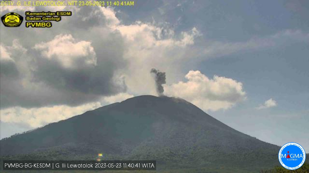
Indonesia , Ili Lewotolok :
An eruption of G. Ili Lewotolok occurred on Tuesday, May 23, 2023 at 11:38 WITA with the height of the ash column observed at ± 600 m above the summit (± 2023 m above sea level) . The ash column was observed to be white to gray with a thick intensity, oriented northwest. This eruption was recorded on a seismograph with a maximum amplitude of 35 mm and a duration of 47 seconds.
VOLCANO OBSERVATORY NOTICE FOR AVIATION – VONA
Issued : May 23 , 2023
Volcano : Ili Lewotolok (264230)
Current Aviation Colour Code : ORANGE
Previous Aviation Colour Code : orange
Source : Ili Lewotolok Volcano Observatory
Notice Number : 2023LEW028
Volcano Location : S 08 deg 16 min 19 sec E 123 deg 30 min 18 sec
Area : East Nusa Tenggara, Indonesia
Summit Elevation : 4554 FT (1423 M)
Volcanic Activity Summary :
Eruption with volcanic ash cloud at 03h38 UTC (11h38 local).
Volcanic Cloud Height :
Best estimate of ash-cloud top is around 6474 FT (2023 M) above sea level or 1920 FT (600 M) above summit. May be higher than what can be observed clearly. Source of height data: ground observer.
Other Volcanic Cloud Information :
Ash cloud moving to northwest. Volcanic ash is observed to be white to gray. The intensity of volcanic ash is observed to be thick.
Remarks :
Eruption recorded on seismogram with maximum amplitude 35 mm and maximum duration 47 second.
Source : Magma Indonésie.
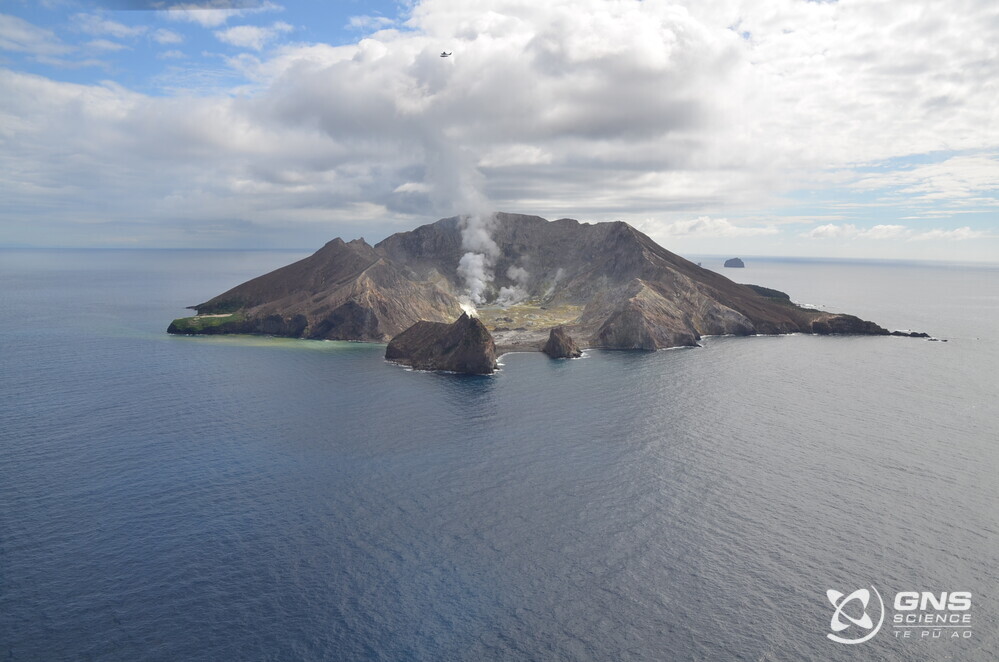
New Zealand , White Island :
Whakatane-based webcam images and monitoring flights confirm continuing steam and gas plumes, and no significant changes in the active crater. The Volcanic Alert Level remains at 2.
Observations from the Whakatane webcam show that Whakaari/White Island continues to emit steam and gas. Additionally, as the weather allows, we are continuing regular gas measurement and observation flights. The most recent flights last month showed the steam and gas plume continues to originate from the same vent locations as previously observed, with discharge rates in a similar range. There has been no evidence of ash emission or eruptive activity from these vents.
Following the recent severe weather, one of our surviving on-island sites has not recovered. Consequently, we can no longer receive data from the North Rim webcam and the Crater Floor GNSS (GPS) sensor. These were our last remaining reliable sensors on the island. We continue to make regular observation and gas measurement flights to monitor the status of the island (Figure 1). We obtain satellite-based ground deformation data approximately every 10 days that allows us to observe ground deformation trends. These are complimented by daily satellite-based Sulphur Dioxide (SO2) emission measurements, although this technique is not as sensitive as our gas measurements during flights. Neither of these satellite techniques have detected significant changes in the overall activity at the volcano over the past few months.
The Volcanic Alert Level remains at Level 2 (moderate to heightened unrest) and the Aviation Colour Code remains at Yellow, acknowledging the current level of activity, but also continuing to consider the greater level of uncertainty in our interpretation due to the current lack of consistent, useful real-time data.
As the weather allows, we will continue to undertake gas measurement and observation flights over the island until we can service our on-island equipment and power supplies.
Source : Geonet / Paul Jarvis / Duty Volcanologist
Photo : BJ Scott.
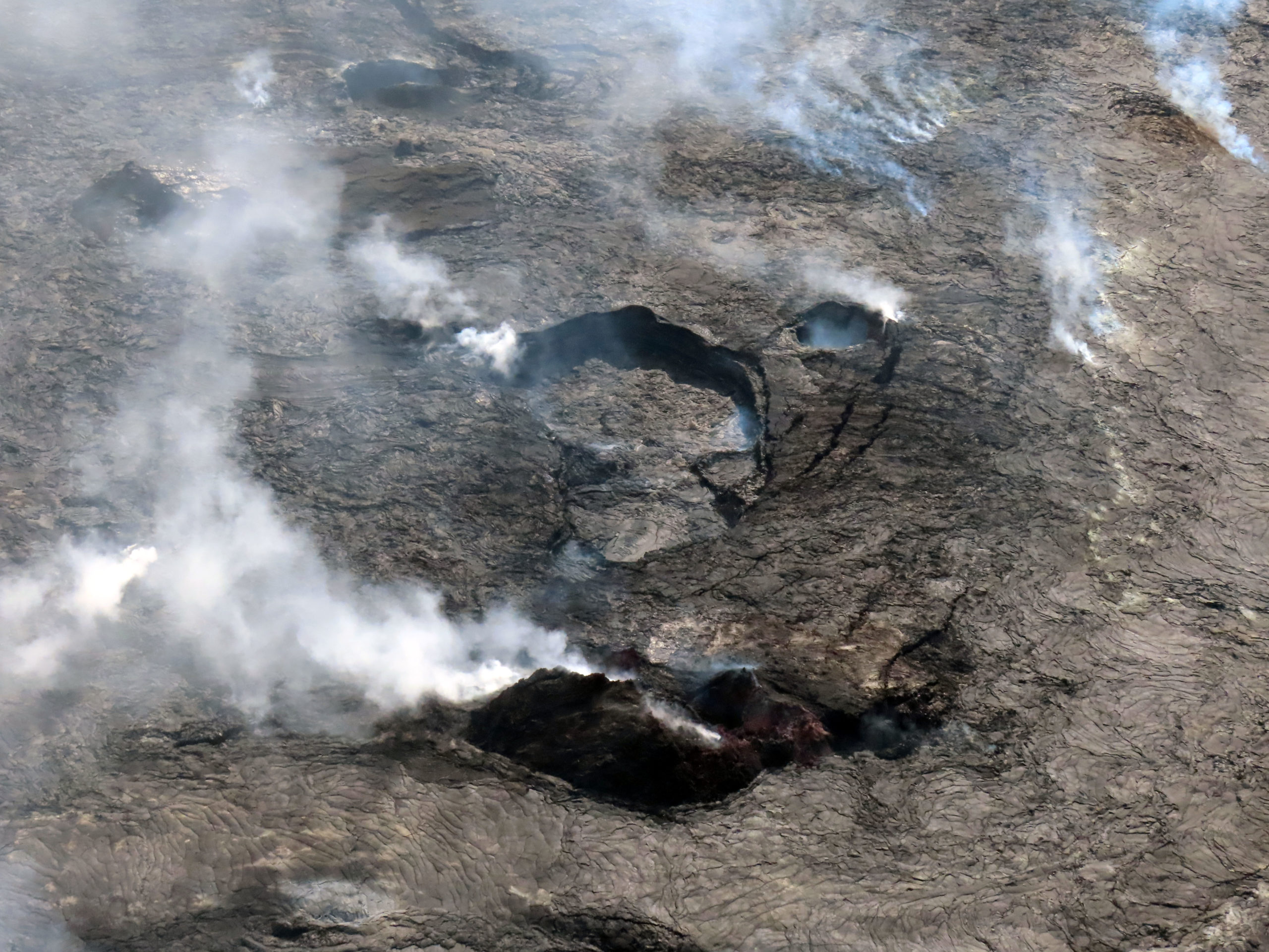
Hawaii , Kilauea :
Monday, May 22, 2023, 6:47 PM HST (Tuesday, May 23, 2023, 04:47 UTC)
19°25’16 » N 155°17’13 » W,
Summit Elevation 4091 ft (1247 m)
Current Volcano Alert Level: ADVISORY
Current Aviation Color Code: YELLOW
Kīlauea volcano is not erupting. Kīlauea summit is currently exhibiting signs of heightened unrest. No unusual activity has been noted along Kīlauea’s East Rift Zone or Southwest Rift Zone.
Earthquake rates are elevated beneath Kīlauea summit and Nāmakanipaio. Small flurries of earthquakes are occurring irregularly. Earthquake rates have increased over the past week. More than 100 earthquakes were recorded on Saturday, May 20, including a magnitude-3.7 event that was felt in Hawai’i Volcanoes National Park and surrounding communities. Most of these earthquakes have been smaller than magnitude-2 and not reported felt.
Ground deformation rates are also elevated at the summit of Kīlauea. Overall, inflation is higher than conditions preceding the January 5, 2023, summit eruption.
Gas emissions remain low, reflective of the current lack in eruptive activity at the summit.
These observations indicate that magma is accumulating beneath the surface of Kīlauea’s summit region. An eruption at Kīlauea’s summit does not appear to be imminent, although heightened unrest suggests that an eruption at Kīlaueaʻs summit might be possible with little or no warning.
The Hawaiian Volcano Observatory continues to monitor Kīlauea and other Hawaiian volcanoes for any changes.
Source : HVO.
Photo : USGS/J. Schmith ,
Peru , Sabancaya :
Analysis period: from May 15, 2023 to May 21, 2023, Arequipa, May 22, 2023.
Alert level: ORANGE
The Geophysical Institute of Peru (IGP) reports that the eruptive activity of the Sabancaya volcano remains at moderate levels, that is to say with the recording of an average of 37 daily explosions, with columns of ash and of gas up to 2.4 km altitude above the summit of the volcano and their subsequent dispersion. Therefore, for the following days, no significant change is expected in eruptive activity.
The IGP recorded and analyzed the occurrence of 232 earthquakes of volcanic origin, associated with the circulation of magmatic fluids inside the Sabancaya volcano. An average of 37 explosions was recorded daily, in addition to recording Volcano-Tectonic (VT) type events associated with rock fracturing inside the Sabancaya volcano.
Monitoring the deformation of the volcanic structure using GNSS techniques (processed with fast orbits) does not show any significant anomalies. However, in general, a slight inflation process was observed in the northern sector (surroundings of the Hualca Hualca volcano). Visual surveillance identified columns of gas and ash up to 2.4 km above the summit of the volcano, which were dispersed towards the eastern and northeast sectors of Sabancaya. It should be noted that on May 19, it was observed that the ashes dispersed towards the Southeast, towards the city of Arequipa. Satellite recordings have identified the presence of 8 thermal anomalies, with a maximum value of 12 MW, associated with the presence of a lava body on the surface of the crater of the volcano.
RECOMMENDATIONS
• Keep the volcanic alert level orange.
• Do not approach within a radius of less than 12 km from the crater.
Source : Cenvul.
Photo : IGP