May 05 , 2023.
Iceland , Katla :
Aviation warning level raised to yellow over Katla volcano
A powerful series of earthquakes has begun in the caldera of the Katla volcano. A yellow alert for air traffic has been declared.
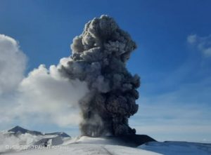
A swarm of powerful earthquakes began in the caldera of the Katla volcano, covered by the Mýrdalsjökull glacier. The colour of the aviation warning alert has been changed to yellow.
The Icelandic Met Office reports that the tremors began at 09:41 a.m. The strongest recorded tremor reached a magnitude of 4.8 on the Richter scale. All four major tremors exceeded 4 degrees: the other three were 4.5, 4.3 and 4.2 degrees on the Richter scale. It should be noted that thorough analysis is still being done, and the final strength of the tremors will be confirmed.
So far, no volcanic unrest (editor’s note: the phenomenon immediately preceding the eruption) has been reported, and earthquakes regularly occur under the Mýrdalsjökull glacier.
Páll Einarsson, a geophysicist, said in an interview with RÚV this morning that there had been a lot of activity in Katla over the past few weeks.
« It’s all interesting because it’s a rather unusual time of year for this seismic activity, » he said. What’s unusual about Katla is that its activity has been limited to specific months, and tremors usually occur in August, September and October. »
Páll believes there is no need to worry about these tremors, but it is something to pay attention to. Einar Freyr Elínarson, mayor of the Mýrdalshreppur municipality, who was not affected by today’s earthquakes, made a similar statement. « No one is stressed by it, » – he says.
Morning tremors in the Reykjanestá area
A 3.4 earthquake occurred near Cape Reykjanestá (editor’s note: the southern cape of the Reykjanes Peninsula) at 8 a.m. today. The tremors began around 7:30 this morning; about 20 have been recorded there since then. The Met Office reports that the quake calmed as the morning progressed.
Update: since the article was published, there has been a tremor of 4.8 on the Richter scale. The article has been corrected, as it was previously reported that the strongest tremor had a magnitude of 4.5.
Source : RUV.
Photo : RÚV – Einar Rafnsson
Guatemala , Fuego :
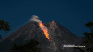
This morning at 02.00 hrs, Fuego entered a new eruptive stage. A report published this morning at 05.10 hrs by the INSIVUMEH (Guatemalan Institute of seismology, volcanology, meteorology, and hydrology) stated this new stage was punctuated by a lava flow in the Ceniza Canyon, followed by constant incandescent activity and gas and ash emissions, forming avalanches to the south and southwest.
An additional report at 05.45 hrs noted a 5 km exclusion zone around the volcano and provided recommendations for the public on how to handle the increased volcanic activity. Recommendations included wearing a face covering to prevent inhaling ash and being aware of evacuation routes.

This morning, at 06.50 hrs, strong explosive activity produced an eruptive column of ash and gas that reached 5,500 – 5,800 m asl (1,737 – 2,037 m above the crater summit).
The violent ash explosion has produced pyroclastic flows extending town the Ceniza and Las Lajas canyons but it is possible pyroclastic activity could extend beyond these volcanic gullies.
At 09.45 hrs CONRED announced the closure of the RN14 road in two locations as a preventative measure.
As of 10.00 hrs, pyroclastic flows have also reached the Seca and Santa Teresa canyons, situated on the western volcanic flank. The eruptive column is now over 6,000 m asl (2,237 m above the crater summit)and has spread over 70 km, expected to reach over 100 km within the next six hours.
Source : Volcanodiscovery / Lois. https://www.volcanodiscovery.com/fuego/news/210717/Fuego-Volcano-South-Central-Guatemala-Strong-explosive-activity-triggers-new-eruptive-phase-and-pyro.html?fbclid=IwAR0ZyXlA6vU1TGij7hzdU8GkMGoEJ7vt-KH-0uTB5DB48-JIy8kxcLVYa14
Photo : Crelosa.
Italy , Vulcano :
WEEKLY BULLETIN, from April 24, 2023 to April 30, 2023. (issue date 02 May 2023)
ACTIVITY STATUS SUMMARY
In the light of the monitoring data, it is highlighted:
1) Temperature of the crater fumaroles: along the summit rim, the emission temperatures are homogeneous and do not show significant variations
2) CO2 flux in the crater area: The CO2 flux in the crater area is stable on average degassing values (less than 10,000 g/m2/day).
3) SO2 flux in the crater area: at an average level
4) Geochemistry of fumarolic gases: The chemical composition of fumarolic gases indicates constant values on the average levels of the concentration of magmatic species. The helium isotope ratio continues a slightly decreasing trend.
5) CO2 fluxes at the base of the La Fossa cone and in the Vulcano Porto area: The CO2 fluxes recorded at the sites of Rimessa, C. Sicilia show stable values, always above background levels. The P4max site displays medium-low values, while values close to the background level are recorded at the Faraglione site.
6) Geochemistry of thermal aquifers: stable but still high temperature values are recorded in the Camping Sicilia well and do not show variations in conductivity values; in the Bambara well, no significant change in the monitored parameters was observed.
7) Local seismicity: Low occurrence rate of local micro-seismicity.

8) Regional seismicity: No earthquake with Ml>=1.0 was located, during the week in question, in the area of the island of Vulcano.
9) Deformations – GNSS: No significant change in Vulcano GNSS network data
10) Deformations – Inclinometry: No significant variation is visible in the data from the Vulcano inclination network
11) Gravimetry: No significant change was recorded.
12) Other Comments: Mobile GNSS.
The time series acquired so far by the mobile GNSS network do not show significant variations around the Porto di Levante area.
CO2 FLOW IN THE CRATER AREA
The CO2 flux values emitted from the ground in the uppermost zone to the east of the fumarolic field (VSCS), updated on May 1, show slightly lower values, below 10,000 g m-2 d-1, but always abnormal compared to the average values of the background noise evaluated over the last decade of observations.
Source et photo : INGV.
Colombia , Chiles / Cerro Negro :
Weekly activity bulletin of the volcanic complex of Chiles and Cerro Negro (CVCCN)
Regarding the monitoring of the activity of the VOLCANOES CHILES AND CERRO NEGRO, the MINISTRY OF MINES AND ENERGY through the COLOMBIAN GEOLOGICAL SERVICE (SGC) informs that:
In the period between April 25 and May 1, 2023, there was an increase in occurrence and released seismic energy, compared to previous weeks. The prevailing seismicity continued associated with the fracture of the rock inside the volcano. On the contrary, earthquakes associated with fluid dynamics within the volcanic system showed a decrease in number and energy compared to the previous week.

The vast majority of fracture earthquakes continued to be located in the immediate vicinity and south of the Chiles volcano, at distances of up to 4 km, with depths less than 6 km, from its summit. In the period evaluated, eight events of magnitude greater than or equal to 2.5 occurred, three of which were reported as felt by inhabitants residing in the regions near the CVCCN, corresponding to those recorded on April 25 at 22:16. and at 10:20 p.m., with magnitudes of 4.3 and 3.5, respectively; and that recorded on May 1 at 2:16 p.m., with a magnitude of 3.6.
Deformation processes recorded by sensors installed in volcanoes and by satellite remote sensing also continue.
It is important to clarify that the fluctuating behavior of the CVCCN does not exclude the possibility of high energy earthquakes that could be felt by the inhabitants of the area of influence.
The activity level of the volcanoes remains at:
YELLOW LEVEL ■ (III): CHANGES IN THE BEHAVIOR OF VOLCANIC ACTIVITY.
Source : SGC
Photo : IGEPN
Ecuador , Reventador :
DAILY REPORT OF THE STATE OF THE REVENTADOR VOLCANO, Wednesday May 03, 2023.
Information Geophysical Institute – EPN.
Surface Activity Level: High, Surface Trend: Unchanged
Internal activity level: Moderate, Internal trend: No change
Seismicity: From May 02, 2023, 11:00 a.m. to May 03, 2023, 11:00 a.m.:
Due to transmission problems from the seismic reference station, data from the volcano’s internal seismic records are not available.
Rains / Lahars:
There was rain last night and tomorrow today which did not generate any reports.
Emission / Ash Column:
No emissions have been observed by cameras, nor has the VAAC in Washington released reports of emissions observed by satellites for this volcano.
Other Monitoring Parameters:
There have been no thermal alerts for Reventador Volcano on satellite data in the past 24 hours.
Observation:
According to reports from the Reventador’s caretaker (Freddy Rodríguez), the volcano has remained completely cloudy for the past 24 hours.
Alert level: Orange.
Source : IGEPN.
Photo : Henry Vasconez