January 12 , 2023 .
Hawaii , Kilauea:
Wednesday, January 11, 2023, 9:21 AM HST (Wednesday, January 11, 2023, 19:21 UTC)
19°25’16 » N 155°17’13 » W,
Summit Elevation 4091 ft (1247 m)
Current Volcano Alert Level: WATCH
Current Aviation Color Code: ORANGE
Activity Summary:
The summit eruption of Kīlauea Volcano, within Halemaʻumaʻu crater, continued over the past 24 hours. All recent eruptive activity has been confined to the crater. No significant changes have been observed at the summit or in either rift zone.
Halemaʻumaʻu Lava Lake Observations:
Eruption of lava from vents on the central eastern portion of Halemaʻumaʻu crater floor continued over the past 24 hours. Activity is concentrated in the eastern half of the crater and within the basin in the western half of the crater that was the focus of activity in 2021–2022. The active lava area in the eastern half of the crater has one dominant fountain, and the active area has fluctuated slightly over the past 24 hours.
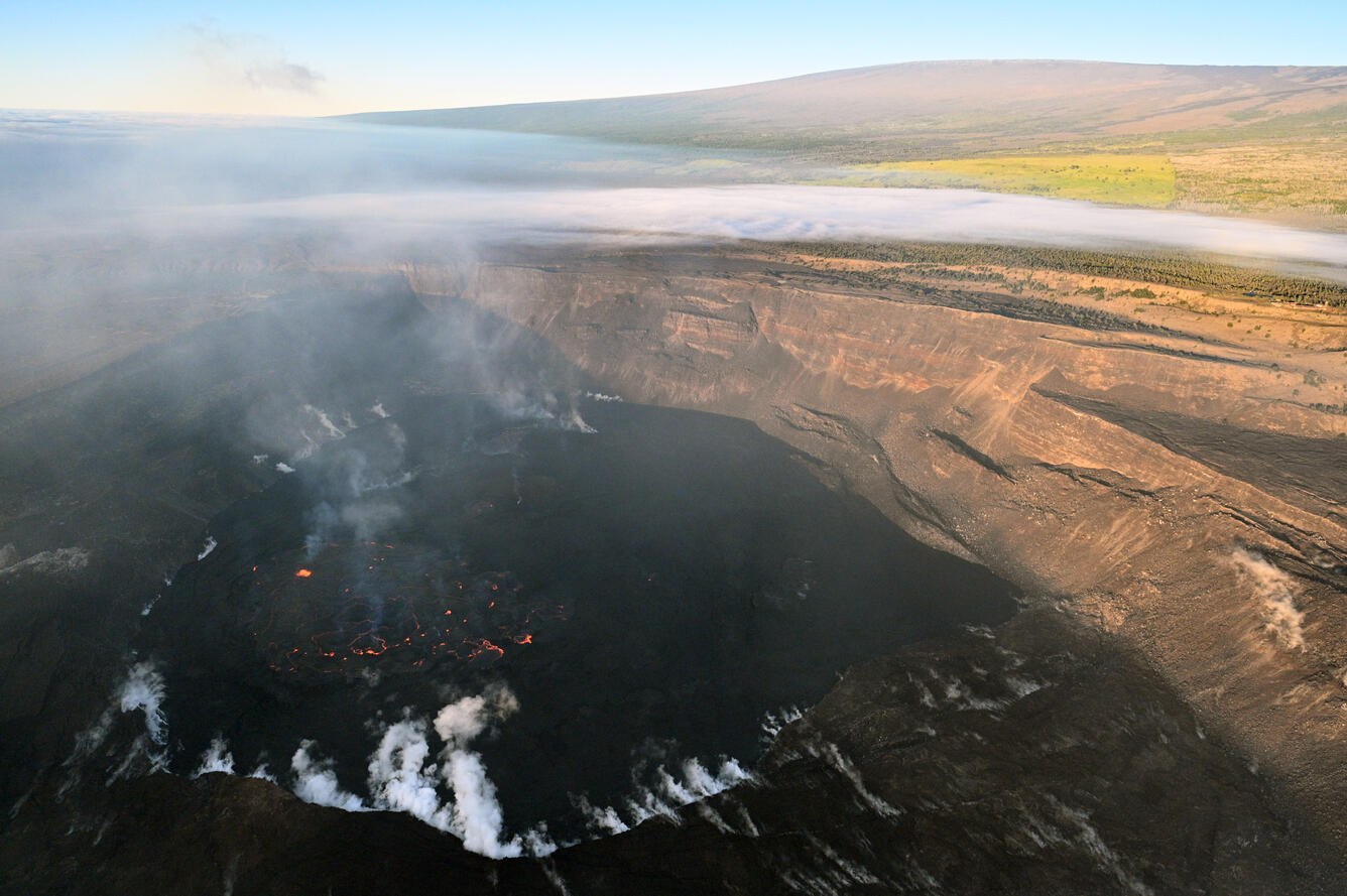
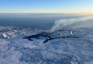
HVO geologists on an early morning helicopter overflight captured this scene of Kīlauea and Mauna Loa. The weather patterns at the time of the flight were causing the plume to stagnate and sit in Halema‘uma‘u, creating this haze shown in the caldera. Lava is still actively erupting within Halema‘uma‘u, seen here as the orange glow.
Summit Observations:
Over the past 24 hours, summit tiltmeters recorded inflation until about midday yesterday, with deflation since then. Volcanic tremor remains above background levels. A sulfur dioxide (SO2) emission rate of approximately 3,500 tonnes per day (t/d) was measured on January 9, 2023.
Rift Zone Observations:
No unusual activity has been noted along the East Rift Zone or Southwest Rift Zone; low rates of ground deformation and seismicity continue along both. Measurements from continuous gas monitoring stations downwind of Puʻuʻōʻō in the middle East Rift Zone remain below detection limits for SO2, indicating that SO2 emissions from Puʻuʻōʻō are negligible.
Source : HVO
Photo : USGS / L. Gallant.
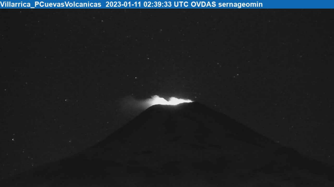
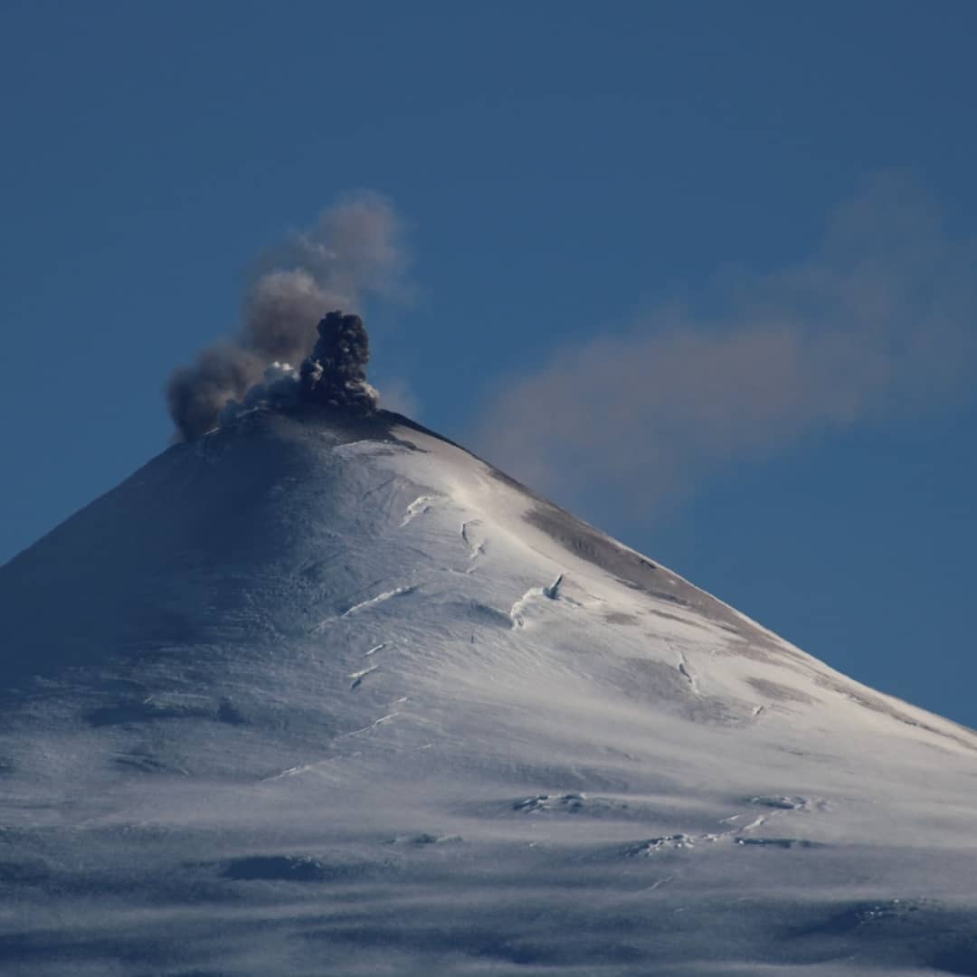
Chile , Villarica :
Special Report on Volcanic Activity (REAV), La Araucanía and Los Ríos regions, Villarrica volcano, January 11, 2023, 00:15 a.m. local time (mainland Chile)
The National Geology and Mining Service of Chile (Sernageomin) announces the following PRELIMINARY information, obtained through the monitoring equipment of the National Volcanic Monitoring Network (RNVV), processed and analyzed at the Observatory of Volcanoes of the Southern Andes (Ovdas):
On Tuesday January 10, 2023, monitoring stations installed near the Villarrica volcano recorded an earthquake associated with fluid dynamics within the volcanic system. (type LP).
The characteristics of the earthquake, after its analysis, are as follows:
ORIGINAL TIME: 23:39 local time (02:39 UTC on January 11, 2023)
REDUCED DISPLAY: 52.03 (cm*cm)
ACOUSTIC SIGNAL: 3.2 Pascals (Pa) reduced to 1 km
The characteristics of this activity are as follows:
MAXIMUM HEIGHT OF THE COLUMN: 40 meters above the point of emission
DIRECTION OF DISPERSION: Southeast (SE).
COMMENTS:
At the time of issuing this report, we continue to record a few episodes of Strombolian activity contained mainly in the crater, the height of the materials did not exceed 100 m above the crater. The seismic activity remains within the parameters observed during the previous days.
The volcanic technical alert is maintained at the Yellow level.
SERNAGEOMIN reported that activity at Villarrica had increased in recent weeks, with explosions ejecting material almost as far as 480 m, near the extent of the 500 m exclusion zone in place around the crater. On 6 January the exclusion zone was increased to 1 km as a preventative measure. The Alert Level remained at Yellow (the second lowest level on a four-color scale). ONEMI maintained the Alert Level at Yellow (the middle level on a three-color scale) for the municipalities of Villarrica, Pucón (16 km N), Curarrehue, and the commune of Panguipulli.
Source : Sernageomin , GVP.
Photos : Sernageomin , volcanologia en chile.
Alaska , Katmai :
Wednesday, January 11, 2023, 2:08 PM AKST (Wednesday, January 11, 2023, 23:08 UTC)
There has been in an increase in the number of located earthquakes beneath a broad swath of volcanoes in the Katmai region beginning in August 2022. Background seismicity in this area, which includes Mount Katmai, Trident Volcano, Mount Mageik, and Mount Martin, is usually less than 30 located earthquakes per week, although there is considerable variation. An earthquake swarm occurred beneath Trident Volcano from August to October 2022, marking the approximate start of this ongoing period of elevated earthquake activity.
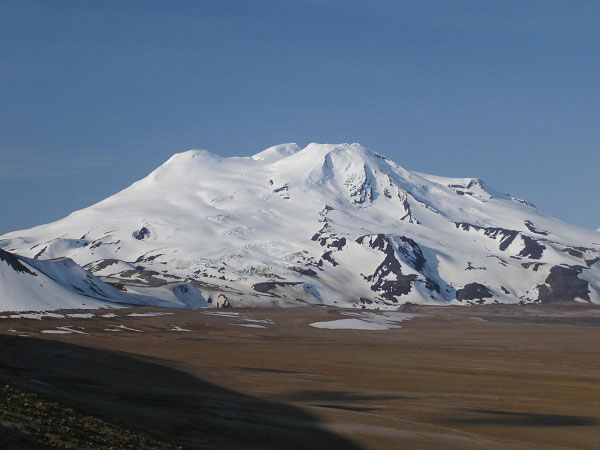
While earthquake activity has been more dispersed across the Katmai region since October, it has remained relatively high. Over the past month it has increased to more than 80 located earthquakes per week. This earthquake activity could be the result of magma movement but there is no indication that an eruption is imminent, or that one will occur. Seismic swarms like this are relatively common at volcanoes and most do not lead to an eruption. There have been no other signs of unrest noted in monitoring data from the region since last August.
AVO will issue additional notices of activity should the earthquakes continue or increase.
Source : AVO
Photo : Mont Mageik , USGS.
New Zealand , Lake Taupo :
The minor volcanic unrest that began in May 2022 continues at Taupō Volcano. Small earthquakes and ground deformation are still being recorded at above background levels. The Volcanic Alert Level remains at 1 (minor volcanic unrest).
The aftershock sequence following the M5.7 earthquake on 30 November 2022 has finished.
The M5.7 generated a small tsunami within Lake Taupō, caused ~175 mm of horizontal and ~180 mm vertical ground movement at Horomatangi , and was followed by a month of aftershocks, with 758 recorded by 31 December 2022 .
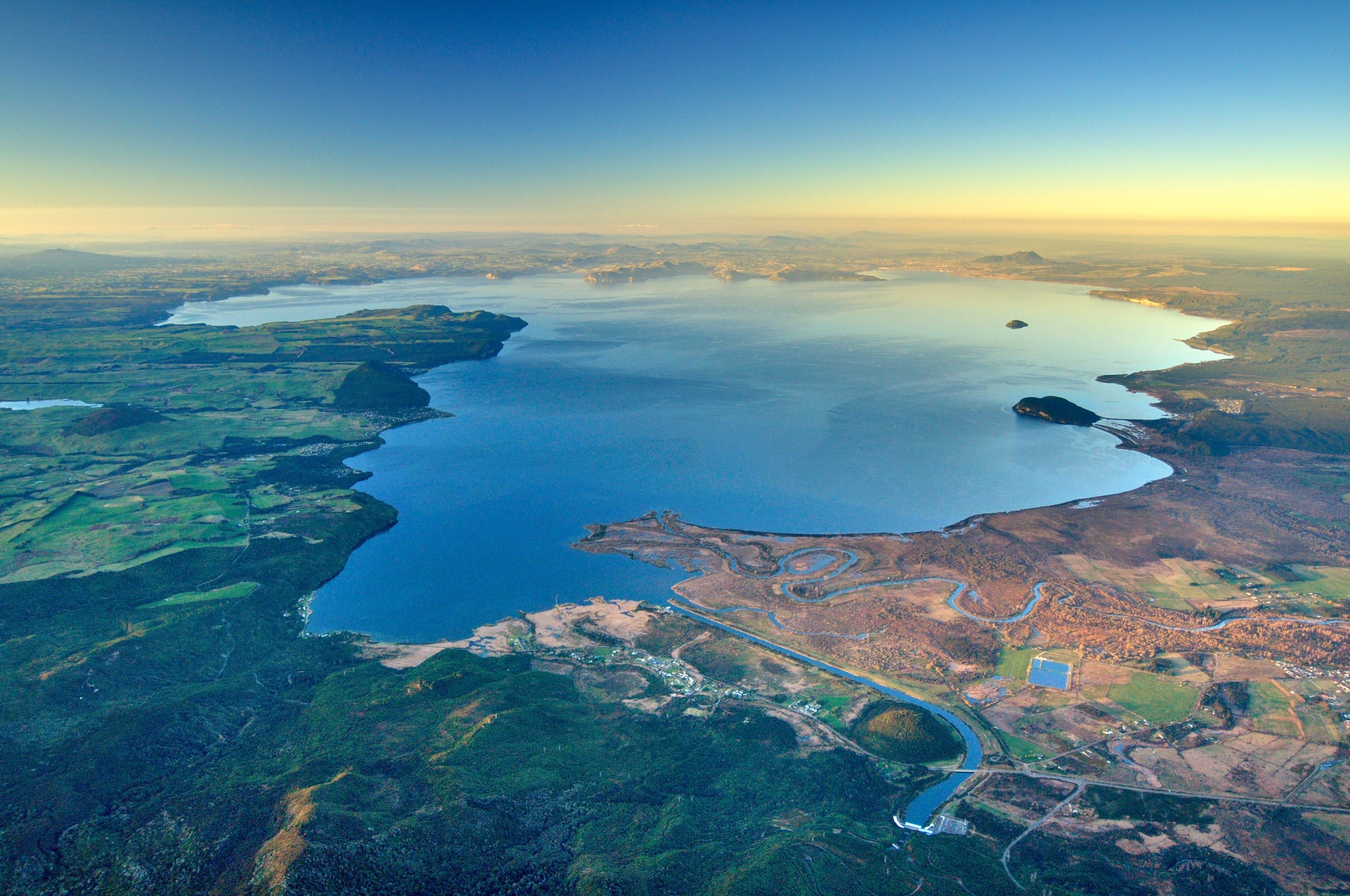
Just under half (46%) of the earthquakes during the 2022/2023 unrest episode are associated with the 30 November 2022 main shock-aftershock sequence. The current rate of earthquakes occurring per week is similar to other times during this period of unrest, indicating minor unrest continues .
Ground deformation (land movement) continues around Lake Taupō, which we measure using GNSS (GPS) instruments and lake levelling surveys. The Horomatangi Reef site continues to move after the 30 November 2022 M5.7 earthquake towards the south-east
Source et photo : Geonet.
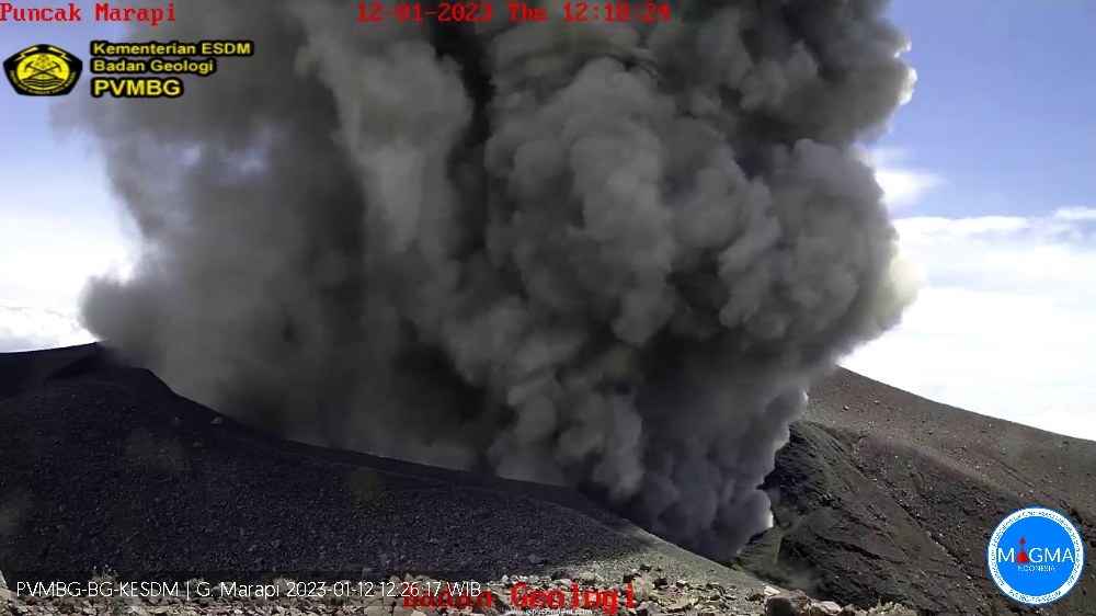
Indonesia , Marapi :
Mount Marapi erupted on Thursday January 12, 2023 at 12:17 WIB with an ash column height observed at ± 700 m above the summit (± 3591 m above sea level). The ash column was observed to be gray with a thick intensity, oriented northeast and southeast. This eruption was recorded on a seismograph with a maximum amplitude of 5.2 mm and a duration of 131 seconds.
VOLCANO OBSERVATORY NOTICE FOR AVIATION – VONA
Issued : January 12 , 2023
Volcano : Marapi (261140)
Current Aviation Colour Code : ORANGE
Previous Aviation Colour Code : orange
Source : Marapi Volcano Observatory
Notice Number : 2023MAR026
Volcano Location : S 0 deg 22 min 52 sec E 100 deg 28 min 23 sec
Area : West Sumatra, Indonesia
Summit Elevation : 9251 FT (2891 M)
Volcanic Activity Summary :
Eruption with volcanic ash cloud at 05h17 UTC (12h17 local).
Volcanic Cloud Height :
Best estimate of ash-cloud top is around 11491 FT (3591 M) above sea level or 2240 FT (700 M) above summit. May be higher than what can be observed clearly. Source of height data: ground observer.
Other Volcanic Cloud Information :
Ash cloud moving from northeast to southeast. Volcanic ash is observed to be gray. The intensity of volcanic ash is observed to be thick.
Remarks :
Eruption recorded on seismogram with maximum amplitude 5.2 mm and maximum duration 131 second.
Source et photo : Magma Indonésie.
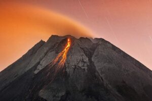
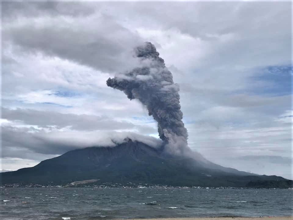
Japan , Sakurajima :
JMA reported ongoing eruptive activity at Minamidake Crater (at Aira Caldera’s Sakurajima volcano) during 2-9 January. Crater incandescence was visible nightly. Sulfur dioxide emissions were slightly elevated at 1,000 tons per day on 4 January. One explosion on 3 January and two explosions on 8 January were recorded by the seismic network. Eruption plumes rose as high as 2.4 km above the crater rim and blocks were ejected as far as 1.1 km from the vent. The Alert Level remained at 3 (on a 5-level scale), and residents were warned to stay 2 km away from the crater.
The Aira caldera in the northern half of Kagoshima Bay contains the post-caldera Sakurajima volcano, one of Japan’s most active. Eruption of the voluminous Ito pyroclastic flow accompanied formation of the 17 x 23 km caldera about 22,000 years ago. The smaller Wakamiko caldera was formed during the early Holocene in the NE corner of the Aira caldera, along with several post-caldera cones. The construction of Sakurajima began about 13,000 years ago on the southern rim of Aira caldera and built an island that was finally joined to the Osumi Peninsula during the major explosive and effusive eruption of 1914. Activity at the Kitadake summit cone ended about 4850 years ago, after which eruptions took place at Minamidake. Frequent historical eruptions, recorded since the 8th century, have deposited ash on Kagoshima, one of Kyushu’s largest cities, located across Kagoshima Bay only 8 km from the summit. The largest historical eruption took place during 1471-76.
Source : GVP.
Photo : Koki Arima ( archive).