August 25 , 2021.
Italy , Stromboli :
Weekly bulletin, from August 16, 2021 to August 22, 2021 (issue date August 24, 2021)
SUMMARY STATEMENT OF ACTIVITY
In view of the monitoring data, it is highlighted:
1) VOLCANOLOGICAL OBSERVATIONS: During this period a normal explosive activity of strombolian type was observed. The total hourly frequency of explosions fluctuated between medium-low and medium values (9-13 events / h). The intensity of the explosions was mainly low in the areas of the North and Center-South Craters.
2) SEISMOLOGY: The seismological parameters monitored do not show significant variations.
3) DEFORMATIONS: The island’s soil deformation monitoring networks have shown no significant changes over the past week.
4) GEOCHEMISTRY: SO2 flux at a medium-low level
The flow of CO2 from the ground to the Pizzo Sopra la Fossa is at average values.
There is no update of the C / S ratio value. The last measurement measured (07/28/2021) is at average values (C / S = 9.6).
The isotopic ratio of Helium dissolved in the thermal aquifer compared to the last sampling of 07/27/2021 is at medium – high values.
5) SATELLITE OBSERVATIONS: The thermal activity in the summit area is low to moderate.
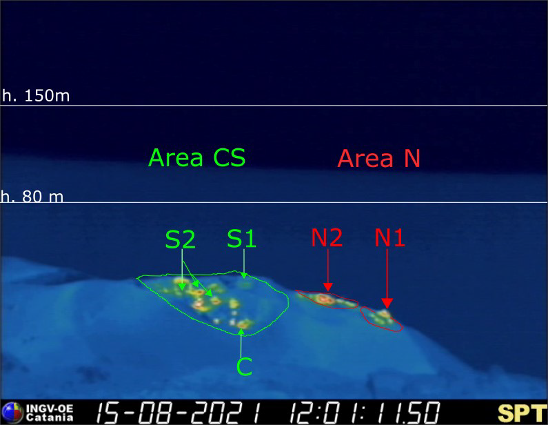
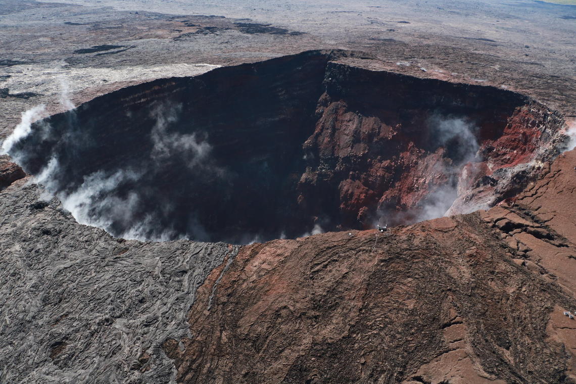
Fig. 1 – The crater terrace seen by the thermal camera placed on the Pizzo sopra la Fossa with the delimitation of the zones of the Center-South and North crater (ZONE N, ZONE C-S respectively). Abbreviations and arrows indicate the names and locations of active vents, the area above the crater terrace is divided into three height ranges relating to the intensity of the explosions.
VOLCANOLOGICAL OBSERVATIONS
During the observation period, the eruptive activity of Stromboli was characterized thanks to the analysis of the images recorded by the surveillance cameras of the INGV-OE (altitude 190, Punta Corvi, altitude 400m and Pizzo). The explosive activity was mainly produced by 3 (three) eruptive chimneys located in the area of the North crater and by 6 (six) eruptive chimneys located in the area of the Center-South Craters. All the vents are placed inside the depression which occupies the terrace of the crater (Fig. 1).
Due to adverse weather conditions, the visibility of the crater terrace on August 21 was not sufficient for a correct description of the explosive activity.
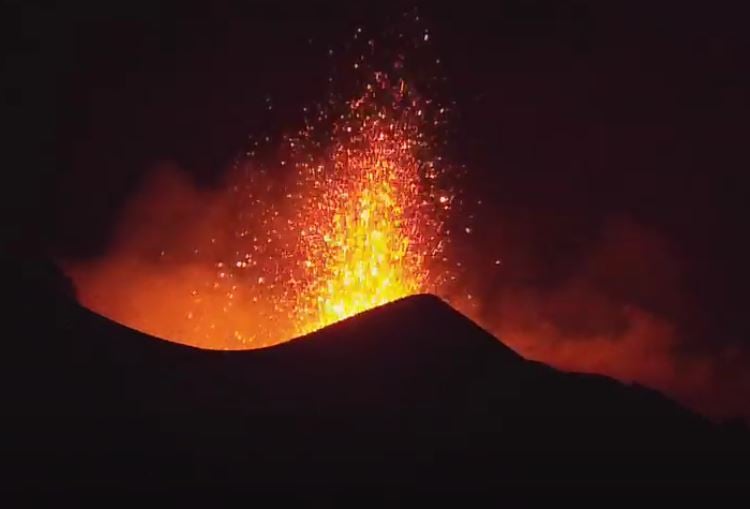
The N1 crater located in the northern zone, with two emission points, produced low intensity explosions (less than 80 m in height) emitting coarse materials (lapilli and bombs) which fell abundantly with a radial distribution. Vent N2 showed low intensity explosive activity (less than 80 m high) emitting fine material sometimes mixed with coarse material. The average frequency of explosions varied from 3 to 5 events / h.
In the Center-South zone, the S1 vent, located on the cone facing the Sciara, sporadically produced low-intensity explosions, emitting fine materials, sometimes mixed with coarse materials, while the three vents located in the sector S2 produced low intensity explosions projecting coarse materials mixed with fine materials. Sector C produced degassing activities. The frequency of the explosions varied from 5 to 9 events / h.
Source : INGV
Photos : INGV , ilvulcanoapiedi
Italy / Sicily , Etna :
Weekly bulletin, from August 16, 2021 to August 22, 2021 (issue date August 24, 2021)
SUMMARY STATEMENT OF ACTIVITY.
In view of the monitoring data, it is highlighted:
1) VOLCANOLOGICAL OBSERVATIONS: Pulsed degassing of the Bocca Nuova crater, ordinary degassing of the other summit craters.
2) SEISMOLOGY: Weak fracturing activity. Low amplitude of tremor.
3) INFRASOUND: overall low infrasound activity
4) DEFORMATIONS: During the last week, there has been no significant change.
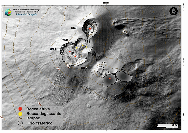
Fig. 3.1 – Map of the summit craters of Etna. BN: Bocca Nuova, VOR: Voragine; NEC: northeast crater; SEC: south-eastern crater. The topographic reference frame on which the morphological updates have been superimposed is linked to the 2014 DEM developed by the Aero-geophysical Laboratory – Section Rome 2.
5) GEOCHEMISTRY: The flow of HCl appears at a medium-low level
Medium level SO2 flux
The flux of CO2 emitted by the soil shows a downward trend and is at low values.
The partial pressure of CO2 dissolved in water does not show significant variations.
The isotopic ratio of helium is on average – high values (last sampling of 07/26/2021)
There are no updates for the C / S report.
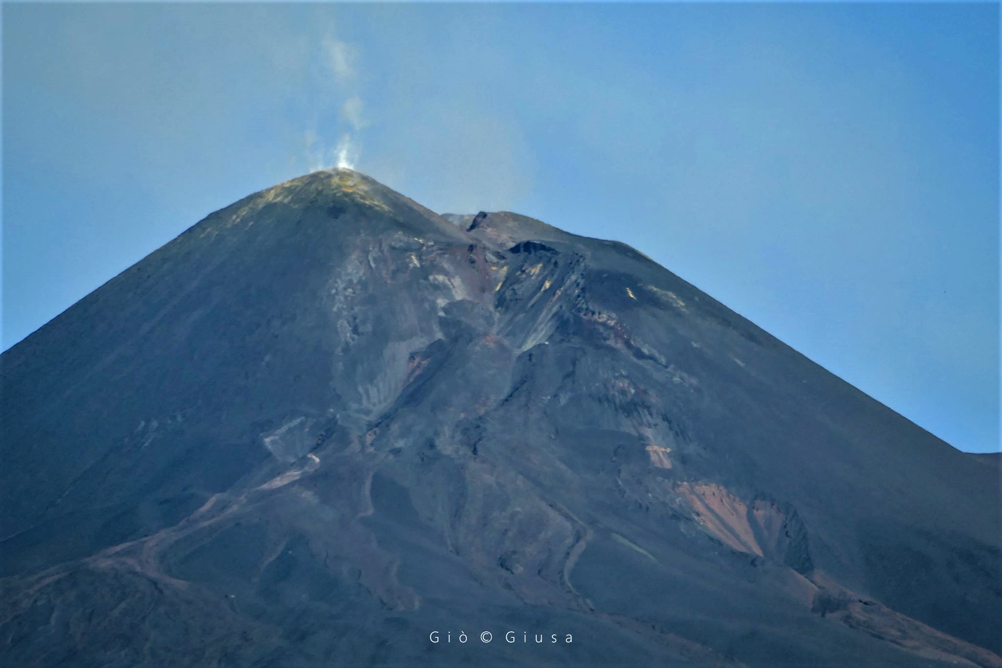
6) SATELLITE OBSERVATIONS: The thermal activity in the summit area was low to moderate.
VOLCANOLOGICAL OBSERVATIONS
During the week, the monitoring of the volcanic activity of Etna was carried out thanks to the analysis of the images of the surveillance cameras of the INGV, Osservatorio Etneo (INGV-OE). Due to the cloud cover that characterized part of certain days of the week, the observation of volcanic activity by the cameras was discontinuous.
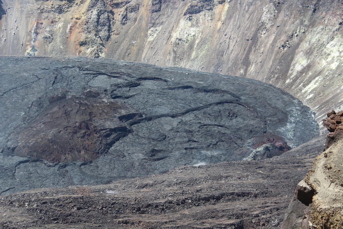
The week was characterized by degassing activities of all the summit craters (Fig. 3.1).
In particular, during the week, the crater of Bocca Nuova (BN) fed a pulsed and almost continuous degassing, presumably from the two vents currently active inside it. The Northeast Crater (NEC) produced intense degassing at a variable rate and the Southeast Crater (SEC) supplied continuous degassing from the fumaroles placed on the eastern edge.
Finally, the Voragine crater (VOR) was characterized by fumarolic degassing.
Volcanic tremor:
The magnitude of the tremor for the week of August 16 to 22, 2021 is low. The locations of the sources are concentrated in the area of the central craters. The depths vary from 1.5 km to 3 km altitude.
Source : INGV
Photos : INGV , Gio Giusa.
Hawaii , Kilauea :
HVO/USGS Volcanic Activity Notice
Current Volcano Alert Level: WATCH
Previous Volcano Alert Level: ADVISORY
Current Aviation Color Code: ORANGE
Previous Aviation Color Code: YELLOW
Issued: Tuesday, August 24, 2021, 5:34 AM HST
Source: Hawaiian Volcano Observatory
Notice Number: 2021/H238
Location: N 19 deg 25 min W 155 deg 17 min
Elevation: 4091 ft (1247 m)
Area: Hawaii
Volcanic Activity Summary:
Kīlauea volcano is not erupting. A swarm of earthquakes beneath the south part of Kīlauea caldera, within Hawaiʻi Volcanoes National Park, began on the evening of August 23, 2021. The swarm continues into the early morning hours of August 24 with a particularly strong sequence of earthquakes that occurred at about 1:30 a.m., HST. The onset of the earthquake swarm was coincident with a change in the style of ground deformation at tiltmeters in the Kīlauea summit region, potentially indicating the shallow movement of magma beneath the south part of Kīlauea caldera.
The US Geological Survey Hawaiian Volcano Observatory is raising the volcano alert level/aviation color code for Kīlauea from Advisory/Yellow to Watch/Orange due to this activity.
HVO will continue to monitor this activity closely and adjust the alert level accordingly.
HVO is in constant communication with Hawai‘i Volcanoes National Park as this situation evolves. The activity is confined entirely within the park.
Remarks:
The US Geological Survey Hawaiian Volcano Observatory has detected an increase in earthquake activity beneath the south part of Kīlauea summit caldera, within Hawaiʻi Volcanoes National Park. The activity began around 4:30 p.m., HST, on August 23 and continued through the night and into the early morning of August 24, 2021. The swarm was accompanied by an increase in the style of ground deformation recorded by the Sandhill tiltmeter, just to the west of the earthquake swarm location. The same tilt increase was also recorded by the tiltmeter near Uēkahuna Bluff and the site of the old HVO building.
At about 1:30 a.m. this morning, the swarm of earthquakes intensified in this region; this activity may indicate an intrusion of magma occurring 1–2 km (0.6–1.2 miles) beneath the south caldera.
Over 140 earthquakes have been recorded as of 4:30 a.m. on August 24; the largest recorded earthquake was magnitude 3.3 with the majority of earthquakes less than magnitude 1. Small earthquakes are continuing at a rate of at least 10 detected earthquakes per hour.
Currently, webcams and satellite imagery show no evidence of lava at the surface. HVO scientists will continue the monitor the situation and will issue additional messages and alert level changes as warranted by changing activity.
Next Notice:
The Hawaiian Volcano Observatory (HVO) continues to closely monitor Kīlauea’s seismicity, deformation, and gas emissions for any changes in activity. HVO will now issue daily Kīlauea updates until further notice.
Source : HVO.
Photos : USGS / M. Zoeller. Pu’u’O’o , USGS/ K. Mulliken
Russia / Northern Kurils , Ebeko :
VOLCANO OBSERVATORY NOTICE FOR AVIATION (VONA)
Issued: August 24 , 2021
Volcano: Ebeko (CAVW #290380)
Current aviation colour code: ORANGE
Previous aviation colour code: orange
Source: KVERT
Notice Number: 2021-103
Volcano Location: N 50 deg 41 min E 156 deg 0 min
Area: Northern Kuriles, Russia
Summit Elevation: 1156 m (3791.68 ft)
Volcanic Activity Summary:
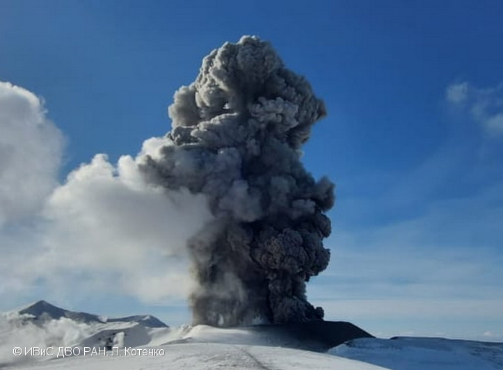
A moderate eruptive activity of the volcano continues. According to visual data by volcanologists from Severo-Kurilsk, an explosion sent ash up to 3.7 km a.s.l., an ash cloud is drifting to the south-east of the volcano.
This activity continues. Ash explosions up to 6 km (19,700 ft) a.s.l. could occur at any time. Ongoing activity could affect low-flying aircraft and airport of Severo-Kurilsk.
Volcanic cloud height:
3700 m (12136 ft) AMSL Time and method of ash plume/cloud height determination: 20210824/2148Z – Visual data
Other volcanic cloud information:
Distance of ash plume/cloud of the volcano: 10 km (6 mi)
Direction of drift of ash plume/cloud of the volcano: SE
Time and method of ash plume/cloud determination: 20210824/2148Z – Visual data
Source : Kvert.
Photo : L. Kotenko. IVS FEB RAS.
Colombia , Nevado del Ruiz :
Weekly activity bulletin of the Nevado del Ruiz volcano
The activity level continues at: Yellow activity level or (III): Changes in the behavior of volcanic activity.
Regarding the monitoring of the activity of the Nevado del Ruiz volcano, the COLOMBIAN GEOLOGICAL SERVICE reports that:
Seismicity related to fluid dynamics inside the volcanic conduits showed an increase in the number of earthquakes recorded and a slight decrease in the levels of seismic energy released compared to the previous week. The increase in the number of long-lasting tremor pulses and earthquakes, with varying energies, continues to be highlighted. Very long-lasting earthquakes have also been recorded. These earthquakes were located mainly in the Arenas crater. Some of these signals were associated with ash emissions, confirmed by cameras installed in the volcano area.
The seismicity generated by the fracturing of the rock decreased the number of earthquakes and maintained similar levels in the seismic energy released compared to the previous week. There is a seismic increase in this type of activity recorded on August 20 and 21 in the northeast sector of the Arenas crater, the depths varied between 2.9 and 4.5 km. The highest magnitude recorded during the increase, the largest of the week, was 1.0 ML (local magnitude), at 5:12 a.m. (local time), located 2.5 km northeast of Arenas crater, 3.7 km deep. The other seismic activity recorded during the week was located mainly in the South-East, South-West sectors and in the Arenas crater. The depths of the earthquakes ranged from 0.6 to 7.0 km.
Regarding the « drumbeat » type seismicity, on August 22, there were two episodes of low energy level associated with the fracturing of the rock. This seismicity has been linked to the processes of ascent, location-growth and evolution of a lava dome1 at the bottom of the Arenas crater of the Nevado del Ruiz volcano.
Source et photo : SGC.
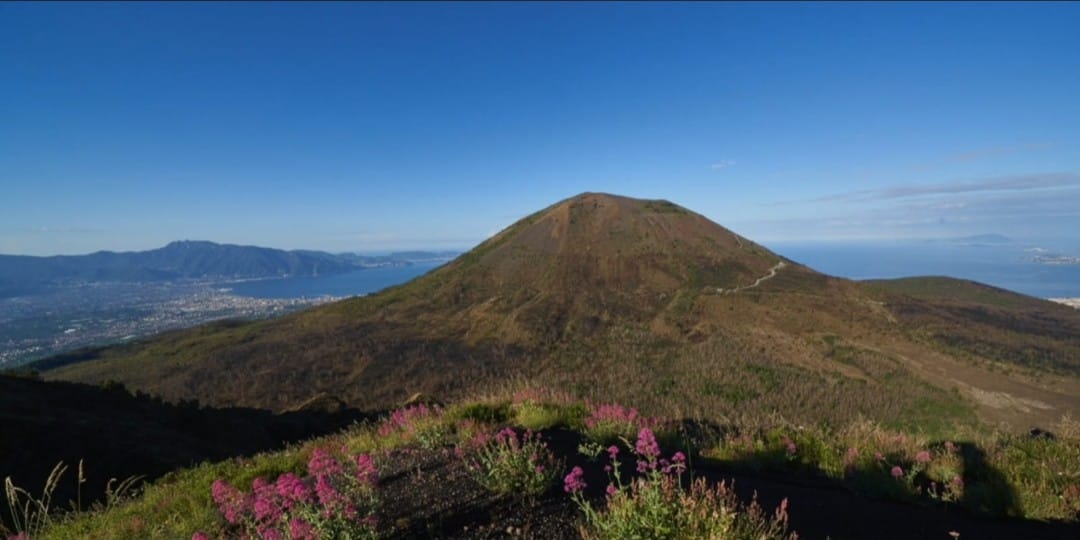
Italy , Pompei :