November 20 , 2020.
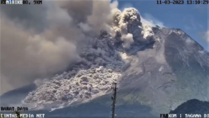
Indonesia , Sinabung :
The activity level has been at level III (SIAGA) since May 20, 2019 at 10:00 a.m. WIB. The Sinabung volcano (2460 m altitude) has been erupting since 2013.
The volcano was clearly visible until it was covered in fog. The crater emits white smoke with medium to thick intensity, about 50-1000 meters above the summit. The weather is sunny / rainy, weak to moderate winds in the South, West and North-West. The temperature is around 17-27 ° C.
According to the seismographs of November 18, 2020, it was recorded:
1 eruption earthquake
1 hot cloud avalanche earthquake
30 avalanche earthquakes
1 emission earthquake.
2 « Tornillo » type earthquakes
12 low frequency earthquakes
2 hybrid / multiphase earthquakes
1 distant tectonic earthquake
VONA: The last VONA code had received the color code ORANGE, published on November 18, 2020 at 13:44:00 WIB. No volcanic ash was observed. The sliding of the hot clouds had been recorded instrumentally for 160 seconds.
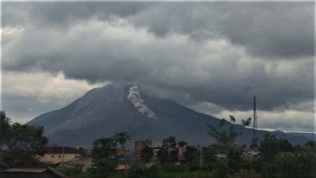
PVMBG reported that during 10-12 November activity at Sinabung was characterized by ash plumes that rose as high as 2 km above the summit, pyroclastic flows that traveled 1.5-2.5 km E and SE, and block avalanches that traveled 200-1,000 m E and SE. Sometimes dense white plumes rose 200-500 m above the summit during 14-16 November. Block avalanches descended the E and SE flanks as far as 1 km during 14-15 November. The Alert Level remained at 3 (on a scale of 1-4), with a general exclusion zone of 3 km and extensions to 5 km in the SE sector and 4 km in the NE sector.
Source : PVMBG. GVP
Photos : Sadrah Peranginangin.
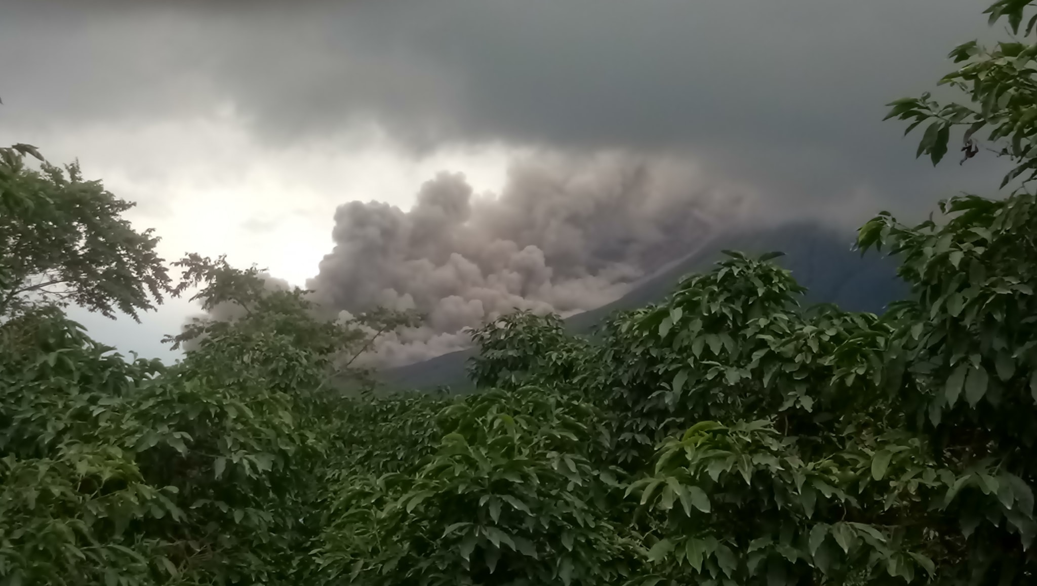
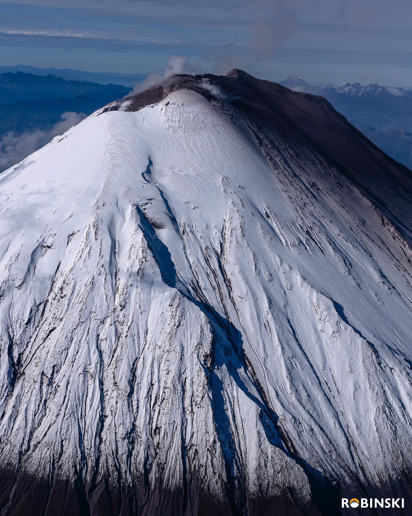
Ecuador , Sangay :
THURSDAY 19 NOVEMBER 2020
The Geophysical Institute of the National Polytechnic School reports that:
Today November 19, the seismic station SAGA records from 14:55 (TL) so far a high frequency signal, possibly associated with the appearance of mudslides and debris (lahars) that descend through the ravines of the volcano. This phenomenon has been recurring since May 2019 and has its origin in the rains on the volcano which remobilize the material accumulated throughout these months of activity. Proximity to rivers is not recommended.
The Geophysical Institute of the National Polytechnic School is keeping an eye on the activity of the volcano and will report on any changes that may be recorded.
DAILY REPORT ON THE STATE OF SANGAY VOLCANO, Sunday November 19, 2020.
Surface activity level: High, Surface trend: Increasing.
Internal activity level: High, Internal trend: Increasing.
Seismicity: From November 18, 2020, 11:00 am to November 19, 2020, 11:00 am:
Long period type events (LP): 53
Emission tremor (TE): 15
Explosions (EXP): 99
Rains / lahars:
In the afternoon and night of yesterday, there were several episodes of rain in the area which did not generate signals associated with flows of mud and debris in the area.
** In case of heavy rains, lahars can be generated in the Volcán, Upano rivers and other tributaries **
Emission / ash column: No emission was observed; however, the VAAC recorded 3 ash emission alerts observed in satellites that reached heights of 900 meters above crater level in a west and south-west direction.
Other monitoring parameters: FIRMS has recorded 8 thermal alerts in the last 24 hours.
Observations: The climatic conditions of the area prevented direct observations of surface activity.
Alert level: yellow.
Sources : INSTITUT GÉOPHYSIQUE / ÉCOLE NATIONALE DE POLYTECHNIQUE.
Photo : Robinski via marina Morozova.
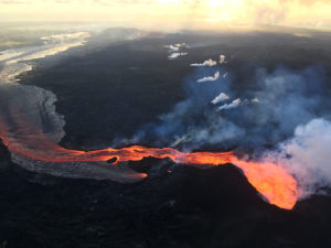
Hawaii , Mauna Loa :
19°28’30 » N 155°36’29 » W,
Summit Elevation 13681 ft (4170 m)
Current Volcano Alert Level: ADVISORY
Current Aviation Color Code: YELLOW
Activity Summary:
Mauna Loa Volcano is not erupting. Rates of deformation and seismicity have not changed significantly over the past week and remain above long-term background levels.

Observations:
During the past week, HVO seismometers recorded 119 small-magnitude earthquakes across the whole volcano, 31 of which were under the volcano’s summit and upper-elevation flanks. Most of these earthquakes occurred at shallow depths of less than 8 kilometers (~5 miles) below ground level.
Global Positioning System (GPS) measurements show overall continued slow summit inflation, consistent with magma supply to the volcano’s shallow storage system.
Gas concentrations and fumarole temperatures at both the summit and Sulphur Cone on the Southwest Rift Zone remain stable.
Webcam views have revealed no changes to the landscape over the past week.
Source et photo : HVO.
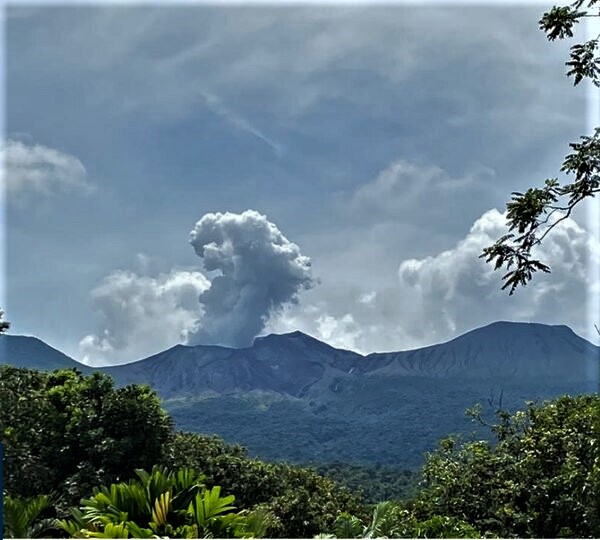
Costa Rica , Turrialba / Poas / Rincon de la Vieja :
Turrialba volcano
Lat: 10.025 ° N; Long: 83.767 ° W;
Altitude: 3340 m.s.n.m.
Current activity level: 2 (active volcano)
Potentially associated hazards: gas, ash emission, proximal ballistic projections.

No ash emission was observed. Seismic activity continues with a high number of daily LP type events and an increase in the number of daily short tremors, which have very diverse characteristics. There were no internal explosions. Geodetic observations confirm that the contraction is less pronounced. The H2S / SO2 ratio is stable with values lower than those of June-July 2020. The CO2 / SO2 and CO2 / Stot ratios are increasing. The SO2 flow is stable, with a low value around 100 t / d. No thermal anomaly was detected by the MODIS analysis. The high level of seismicity is interpreted as infiltration of rainwater into the volcanic building, which, if confirmed, could produce small ash emissions and phreatic eruptions capable of launching ballistic projections.
Poas volcano
Lat: 10.2 ° N; Long: 84.233 ° W;
Altitude: 2780 m.s.n.m.
Current activity level: 2 (active volcano)
Potentially associated hazards: gas, phreatic eruptions, proximal ballistic projections.
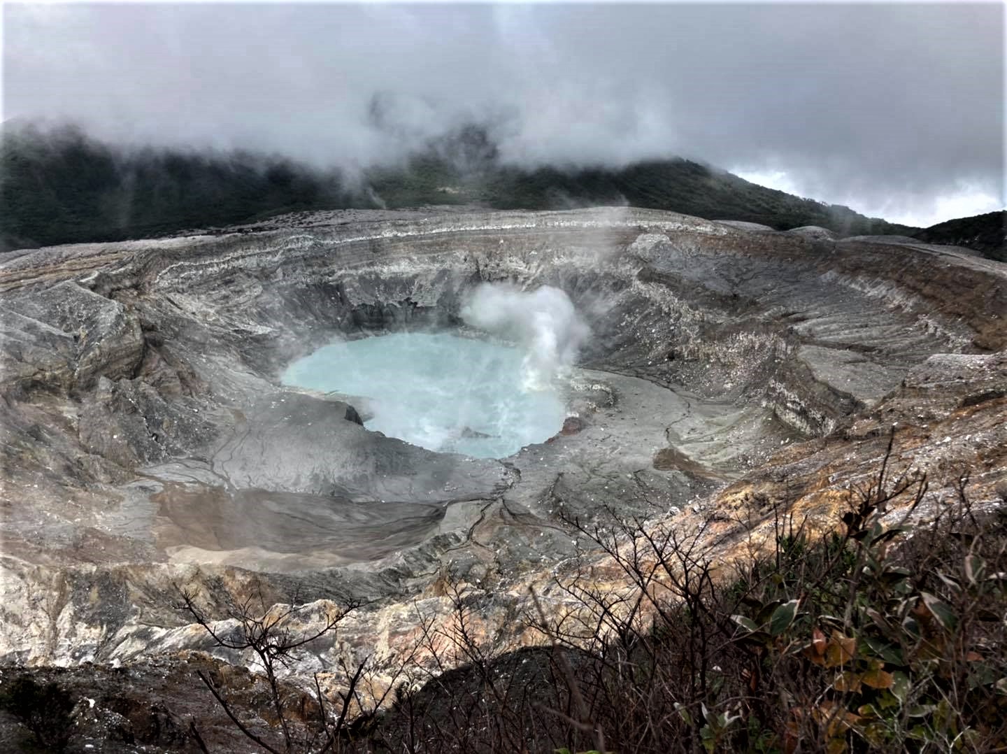
View of the crater of the Poás volcano, taken by RSN staff on November 19, during a maintenance tour of seismological and monitoring equipment.
No eruption was detected. The seismic activity remains stable with 200 to more than 300 daily events, short tremors and an irregular but slightly more active background tremor. There is no significant deformation of the volcanic building. The H2S / SO2 ratio remains high and the SO2 / CO2 ratio remains low. The SO2 flux could not be measured due to an unfavorable wind direction. The lake level has risen by approx. 0.1 m in a week. Evaporation / infiltration rate confirmed a downward trend. No thermal anomaly was detected by the MODIS analysis.
Rincon de la Vieja volcano
Lat: 10.83 ° N; Long: 85.324 ° W;
Altitude: 1895 m.s.n.m.
Current activity level: 3 (erupting volcano)
Potentially associated hazards: gas, phreatic eruptions, proximal ballistic projections, lahars.
The volcano continues with frequent eruptions, on Monday November 16, the 1400th eruption has occurred since the beginning of 2020. These eruptions are now of lower energy. Seismic activity is low despite an increase in the number of daily short tremors. On November 16, 2 landslides were recorded, probably in the active crater. Geodetic monitoring shows a less marked contraction of the summit of the volcano. No thermal anomaly was detected by the MODIS analysis. The SO4 2- / Cl- ratio in a hot spring north of the volcano shows a decrease towards a value similar to that of January-June 2019.
Source : Ovsicori .
Photos : RSN , RSN , CNE .