March 12 , 2023.
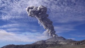
Indonesia , Merapi :
Press release on the latest activities of Mount Merapi, March 11, 2023.
The Geological Agency through the PVMBG-BPPTKG has put the activity level of Mount Merapi at the SIAGA level since November 5, 2020. Mount Merapi was declared to enter an effusive eruption period on January 4, 2021 which was marked by activity in the form of growth of lava domes, avalanches and hot avalanche clouds.
Today, Saturday March 11, 2023 at 12:12 WIB, there was a series of warm clouds descending from the Merapi from an avalanche from the southwest lava dome. As of 3:00 p.m. WIB this afternoon, 21 hot clouds had been recorded with a maximum slip distance of about 4 km to the southwest, especially in the Bebeng and Krasak river channels. At the time of the activity, the wind around Mount Merapi was blowing in a North-North-West direction. These avalanches of hot clouds caused ash rains in several places, in particular on the North-North-West slope of Merapi and reached the City of Magelang.

Internal volcanic activity is also still high, as indicated by seismicity and deformation data. Internal seismicity such as Deep Volcanic Earthquakes (VTA) occurs up to 77 events/day, Shallow Volcanic Earthquakes (VTB) 1 event/day, Multiphase Earthquakes (MP) 6 events/ day and avalanche earthquakes up to 44 incidents/day. Meanwhile, the strain rate of EDM RB1 is 0.5cm/day.
Based on the results of visual and instrumental monitoring, then:
The volcanic activity of Mount Merapi is still at the « SIAGA » level (Level III).
The current danger potential is still in the form of lava avalanches and hot clouds in the South-South-West sector including the Boyong River for a maximum of 5 km, the Bedog River, Krasak, Bebeng for a maximum of 7 km. In the South-East sector, it includes the Woro River for a maximum of 3 km and the Gendol River for 5 km. While the ejection of volcanic material in the event of an explosive eruption can reach a radius of 3 km around the summit.
Yogyakarta, March 11, 2023
VOLCANO OBSERVATORY NOTICE FOR AVIATION – VONA
Issued : March 12 , 2023
Volcano : Merapi (263250)
Current Aviation Colour Code : ORANGE
Previous Aviation Colour Code : orange
Source : Merapi Volcano Observatory
Notice Number : 2023MER003
Volcano Location : S 07 deg 32 min 31 sec E 110 deg 26 min 31 sec
Area : Special Region of Yogyakarta, Indonesia
Summit Elevation : 9498 FT (2968 M)

Volcanic Activity Summary :
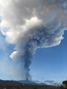
Eruption with volcanic ash cloud at 00h08 UTC (07h08 local).
Volcanic Cloud Height :
Best estimate of ash-cloud top is around 15898 FT (4968 M) above sea level or 6400 FT (2000 M) above summit. May be higher than what can be observed clearly. Source of height data: ground observer.
Other Volcanic Cloud Information :
Ash cloud moving from north to northwest. Volcanic ash is observed to be white to gray. The intensity of volcanic ash is observed from medium to thick.
Remarks :
Eruption recorded on seismogram with maximum amplitude 70 mm and maximum duration 169 second. Ash fall generated by pyroclastic density currents towards south west as far as 2 km.
Source : BPPTKG / Agus Budi Santoso.
Photos : Andi Volcanist, Frekom .
Hawaii , Kilauea :
Saturday, March 11, 2023, 5:56 PM HST (Sunday, March 12, 2023, 03:56 UTC)
19°25’16 » N 155°17’13 » W,
Summit Elevation 4091 ft (1247 m)
Current Volcano Alert Level: WATCH
Current Aviation Color Code: ORANGE
Kīlauea volcano is not erupting. Geophysical signals recorded by the USGS Hawaiian Volcano Observatory indicate that a magmatic intrusion occurred beneath the summit of Kīlauea between approximately 11:00 a.m and 12:00 p.m. HST on March 11, 2023. As of 5:30 p.m. HST, seismicity has returned to background levels, ground deformation has stabilized, and no lava has been observed at the surface. Resumption of eruptive activity at Kīlauea summit no longer appears to be imminent, although it is possible that another intrusion or resumption may occur in the near future with little or no warning.
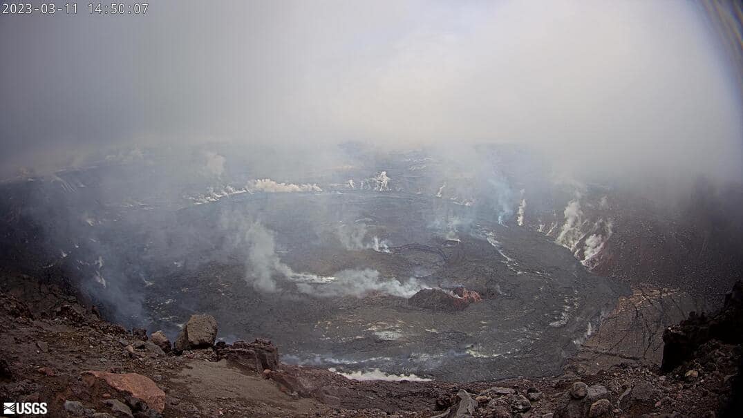
A shallow earthquake swarm was detected beneath the summit of Kīlauea Volcano between 10:30 and 11:00 a.m. HST on March 11, 2023. The swarm was followed by a Magnitude-3.4 earthquake located 4 km SW of Volcano, Hawaii, at a depth of approximately 1 km (0.6 miles) at 11:50 a.m HST. This earthquake was felt locally and triggered a rockfall near Uēaloha (Byron Ledge) in Hawai’I Volcanoes National Park. Seismicity diminished at approximately 12:00 p.m. HST and has since returned to background levels.
HVO tiltmeters have been recording an inflationary signal at Kīlauea summit since March 7, indicating that magma has been accumulating beneath the surface. Tilt excursions also coincided with this morning’s earthquake swarm. Summit tilt has stabilized since approximately 12:00 p.m. HST although slow inflation continues.
The pause in eruptive activity that began approximately five days ago continues and Kīlauea remains at Alert Level WATCH and Aviation Code ORANGE.
No unusual activity has been noted along the East Rift Zone or Southwest Rift Zone.
The Hawaiian Volcano Observatory continues to monitor Hawaiian volcanoes for any changes.
Source : HVO
Photo : USGS.
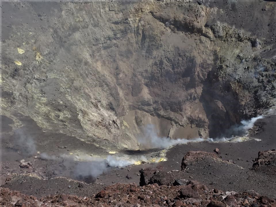
Chile , Lascar :
Special report on volcanic activity (REAV), Antofagasta region, Lascar volcano, March 11, 2023, 10:40 a.m. local time (mainland Chile).
The National Service of Geology and Mines of Chile (Sernageomin) publishes the following PRELIMINARY information, obtained through the monitoring equipment of the National Volcanic Monitoring Network (RNVV), processed and analyzed at the Volcanological Observatory of the Southern Andes ( Ovdas):
On Saturday March 11, 2023, at 10:21 local time (13:21 UTC), the monitoring stations installed near the Lascar volcano recorded a « Tornillo » type earthquake (typeTO) associated with the resonance of the interaction of fluids in the volcanic system.
The characteristics of earthquakes after their analysis are as follows:
ORIGINAL TIME: 10:21 local time (13:21 UTC)
REDUCED DISPLACEMENT: 81 (cm*cm)
COMMENTS:
Following the event, no changes in the seismic behavior of the volcano were recorded. Also, no superficial activity was recorded following the event.
The volcanic technical alert remains at the Orange level.
Sources : Sernageomin.
Photo : Eric Jo ( 2019).
Colombia , Chiles / Cerro Negro :
Bulletin of extraordinary activity of the Chiles and Cerro Negro volcanoes
Regarding the monitoring of the activity of the VOLCANOES CHILES AND CERRO NEGRO, the MINISTRY OF MINES AND ENERGY through the COLOMBIAN GEOLOGICAL SERVICE (SGC) informs that:
Between February 22 and March 1, 2023, 7 earthquakes associated with fluid movements occurred, with the particularity of presenting a very low frequency content, these earthquakes were located about 3 km south of the summit of the Chiles volcano.
On the other hand, since February 28 of this year, changes in the deformation of the volcanic surface of the CVCCN are recorded, which are more evident in the stations near the Chiles volcano.
Today from 4:30 am, the seismicity of the CVCCN records a notorious increase in the occurrence and energy of earthquakes associated with the fracture of the rock which intensify from 9:00 am. From the beginning of the current swarm and until 4:30 p.m. about 2,200 earthquakes were recorded. It was possible to locate about 520 of them, most of which are located south of the Chiles volcano to epicentral distances of 3.5 km and depths between 1 and 6 km (reference level 4,700 m). Among these earthquakes, 36 of magnitude greater than 2 stand out, the largest being the one that occurred at 2:13 p.m. with a magnitude of 2.6. So far, no earthquakes have been reported as felt.
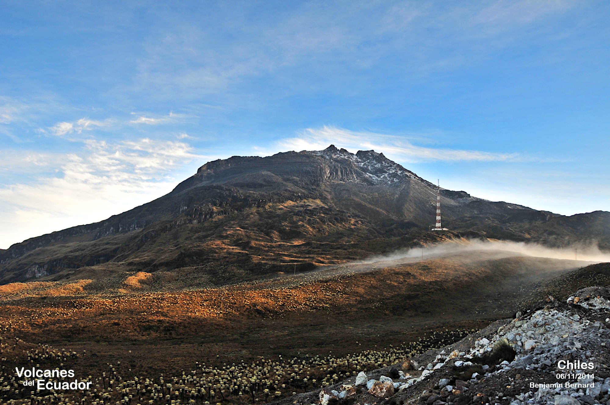
After the extraordinary bulletin issued on March 9 at 4:35 p.m., seismicity continues with high levels, both in occurrence and in seismic energy, with a predominance of earthquakes associated with the fracture of the rock. The increase in the seismic energy released stands out, in particular with the occurrence of three earthquakes of magnitude greater than 3. Earthquakes linked to the movement of fluids inside the volcano which present a very low frequency content were also recorded.
Since the beginning of the increase in this seismic activity, recorded at 4:30 am on March 9 until the time of publication of this report, the frequency of earthquakes has increased considerably, the vast majority of these earthquakes are located near the Chiles volcano and south of it. 86 earthquakes of magnitude greater than 2 were recorded, highlighting those presented at 8:10 p.m. on March 9, at 1:37 a.m. and 5:26 a.m. on March 10, which were felt by some inhabitants of the populations close to these volcanoes, both in Colombia and in Ecuador. This activity was accompanied by a deformation of the surface of the CVCCN.
The possibility of earthquakes with greater energy that can be felt by the inhabitants of the area of influence is not excluded.
The activity level of volcanoes remains at the YELLOW LEVEL ■ (III): CHANGES IN THE BEHAVIOR OF VOLCANIC ACTIVITY
Source : SGC.
Photo : Benjamin Bernard.
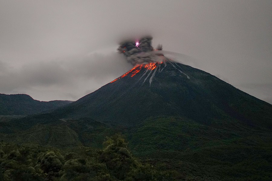
Ecuador , Reventador :
DAILY REPORT OF THE STATE OF THE REVENTADOR VOLCANO, Saturday March 11, 2023.
Information Geophysical Institute – EPN.
Surface Activity Level: High, Surface Trend: Unchanged
Internal activity level: Moderate, Internal trend: No change
Seismicity: From March 10, 2023, 11:00 a.m. to March 11, 2023, 11:00 a.m.:
The seismic monitoring network of the El Reventador volcano has been operational for 24 hours.
Explosion (EXP): 28
Long periods (LP): 32
Emission Tremors (TREMI): 6
Rains / Lahars:
In the early morning of today, rains were recorded in the area, which did not generate any lahar.
Emission / Ash Column:
During the morning today, an emission of about 1000 meters above the level of the crater was observed between the clouds, however, the direction could not be determined due to the cloudiness of the sector .
Other Monitoring Parameters:
No thermal anomalies were recorded in the FIRMS and MIROVA satellite systems during the past 24 hours.
Observation:
The cloudiness was permanent in the sector, however, the emission described above was observed between the clouds. Similarly, during the night, the volcano cleared up on short occasions, showing incandescence at the level of the crater.
Alert level: Orange.
Source : IGEPN.
Photo : Martin Rietze