October 03 2020.
La Réunion , Piton de la Fournaise :
Seismicity:
In October 2020, the OVPF recorded in the Piton de la Fournaise massif in total:
• 129 superficial volcano-tectonic earthquakes (0 to 2.5 km deep below the summit) directly above the summit craters;
• 161 deep earthquakes (2.5 to 5 km deep);
• 369 collapses (in the Crater Dolomieu and at the level of the ramparts of the Enclos Fouqué and the Rivière de l’Est).

Following the magma intrusion of September 28-29, 2020, seismicity persisted in October 2020, both below the summit and under the eastern flank intruded by magma in late September. The deep seismic activity (0.8 to 2.6 km below sea level) under the eastern flank decreased continuously between October 1 and October 8, from 35 to 4 events. The seismic activity under the eastern flank then increased to a level of 1 event per day.
The superficial summit seismic activity, after an increase between October 10 and 16 (seismicity peak with 33 events), remained present until the end of the month with an average of 4 events per day, even if a decrease ( 1 event per day) was observed on the last 4 days of the month.
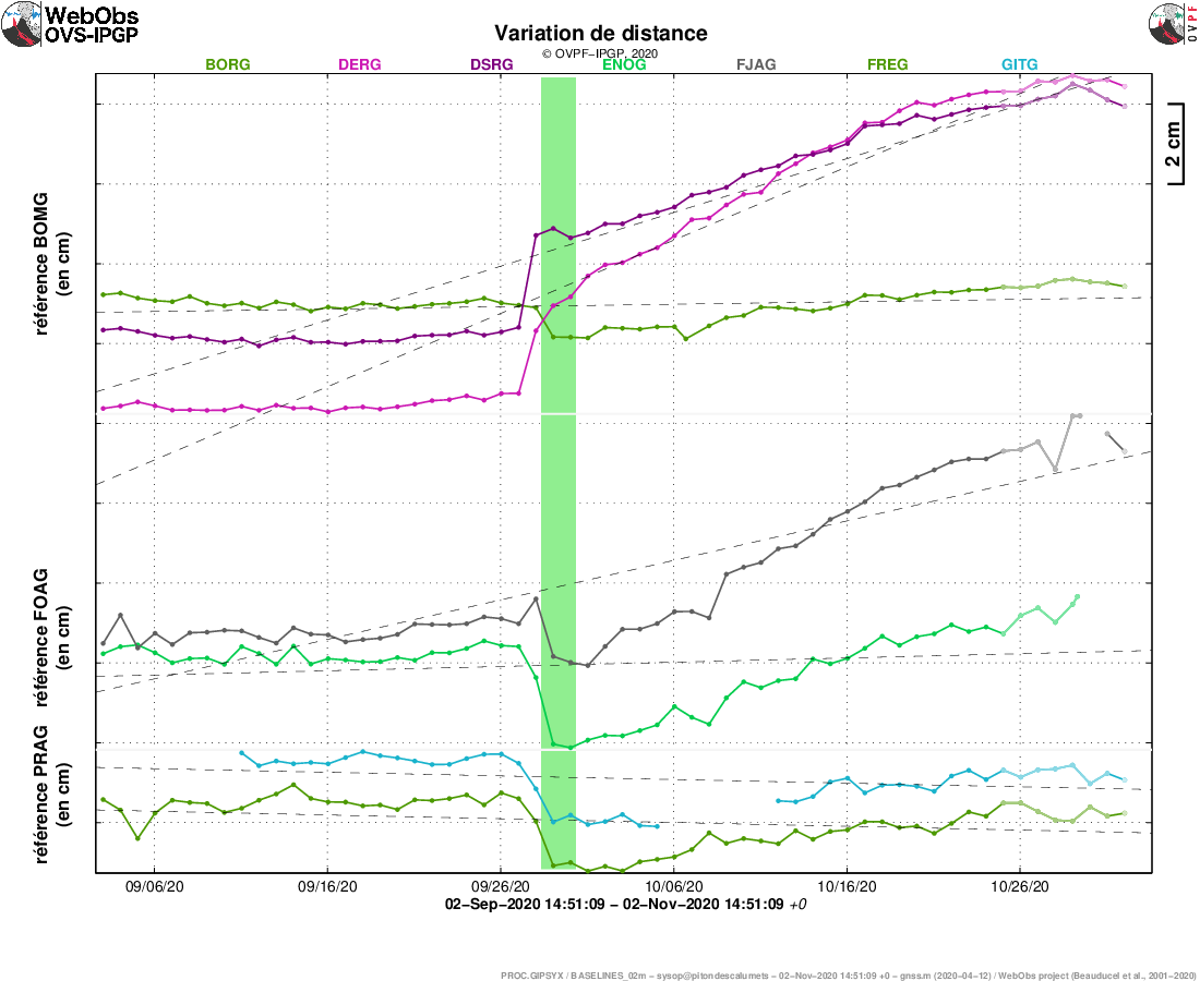
Illustration of the deformation over 2 months. The baselines (variation of distance between two GPS receivers) crossing the Piton de la Fournaise building, at the top (top), the base of the terminal cone (in the middle) and in the far field (bottom) are shown here. ) (see location on the associated maps). A rise is synonymous with elongation and therefore swelling of the volcano; conversely, a decrease is synonymous with contraction and therefore deflation of the volcano. The possible periods colored in light pink correspond to the eruptions.
Deformation:
Following the magmatic intrusion of September 28-29, an inflation (swelling) of the building was again observed throughout the month of October 2020. Thus during the month of October an elongation of about 4 , 4 cm max. of the summit area and an elongation of approx. 5.8 cm max. of the base of the terminal cone were recorded. The digital models of these
deformations show the activation of a pressure source around 1.5 km deep under the Dolomieu crater, corresponding to the pressurization of the superficial magmatic reservoir.
Review:
The continuation of the seismicity under the summit zone and the inflation following the intrusion of September 28-29, as well as the high fluxes of CO2 in the ground were the witnesses of the continuation of the pressurization of the superficial magmatic reservoir and of its recharge by deep magmas throughout the month of October 2020.
Source : OVPF.
Read the full article : http://www.ipgp.fr/sites/default/files/ovpf_20201102_bullmensu.pdf
Photo : Imaz Press .
United-States , Yellowstone :
44°25’48 » N 110°40’12 » W,
Summit Elevation 9203 ft (2805 m)
Current Volcano Alert Level: NORMAL
Current Aviation Color Code: GREEN
Recent work and news
In October, field crews continued maintenance work on monitoring stations in and around Yellowstone National Park, hardening them for the harsh winter months. The remaining semipermanent GPS stations were recovered and downloaded; these will be redeployed in May, as they have been for the past decade. The continuous GPS network of over two dozen stations and the seismic network of about four dozen stations are fully operational, as is the temperature monitoring network at Norris Geyser Basin.
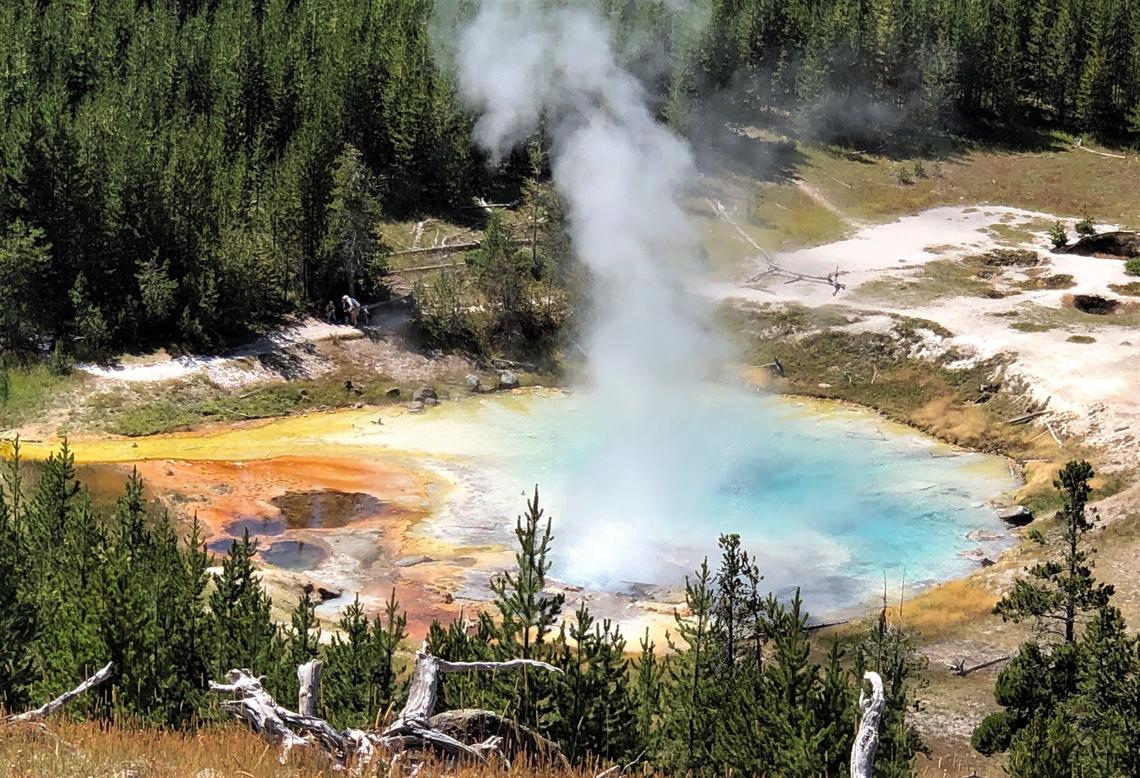
The Imperial Geyser thermal « pool » in Yellowstone National Park is approximately 30m (about 100 feet) in diameter and contains Cl alkaline water with a steam vent in the pool and sludge outside the pool. (in the upper right part of this photo). USGS Photo by Pat Shanks, 2019.
Steamboat Geyser experienced four water eruptions during the month: October 5, 14, 19, and 27. This brings the total number of eruptions for the year to 42.
Seismicity
During October 2020, the University of Utah Seismograph Stations, responsible for the operation and analysis of the Yellowstone Seismic Network, located 86 earthquakes in the Yellowstone National Park region. The largest event was a minor earthquake of magnitude 2.1 located 17 miles northwest of Lake, Yellowstone National Park, on October 2 at 4:34 PM MDT.
No swarm activity was observed in October.
Yellowstone earthquake activity remains at background levels.
Ground deformation
Deformation rates and styles at Yellowstone, as recorded by continuous GPS stations, remain unchanged from last month’s update. Subsidence of Yellowstone Caldera, which has been ongoing since 2015, continued at an average rate of 2-3 cm (about 1 in) per year. In the area of Norris Geyser Basin, little deformation has been detected by a nearby GPS station since the start of 2020.
Source : YVO.
Photo : Pat Shanks. Public domain.
Peru , Sabancaya :
Analysis period: October 26, 2020 to November 01, 2020, Arequipa, November 02, 2020.
Alert level: ORANGE
The Geophysical Institute of Peru (IGP) reports that the eruptive activity of the Sabancaya volcano remains at moderate levels, that is, with the continuous recording of explosions with columns of ash and gas up to 3 km of altitude above the summit of the volcano and their consecutive dispersion. Therefore, for the following days, no significant change is expected in the eruptive activity.
The IGP recorded and analyzed the occurrence of 1993 earthquakes of volcanic origin, associated with the circulation of magmatic fluids inside the Sabancaya volcano. An average of 35 explosions were recorded daily of low to medium intensity. During this period, Volcano-Tectonic (VT) earthquakes were located mainly in the North-West and East of Sabancaya and presented magnitudes between M1.6 and M2.7. The most representative earthquake (M2.7) was recorded on October 31 at 4:30 a.m., 12 km south-east of Sabancaya and 8 km deep.

The monitoring of the deformation of the volcanic structure using GNSS techniques (processed with fast orbits) does not present any significant anomalies. However, in general, an inflation process has been observed in the south-eastern sector of Sabancaya and in the north sector (Hualca Hualca volcano). Visual surveillance identified columns of gas and ash up to 3 km altitude above the summit of the volcano, which were scattered to the southwest, west, northwest and south. -East Sabancaya. Satellite monitoring has identified the presence of 9 thermal anomalies with values between 4 MW and 42 MW, associated with the presence of a lava body on the surface of the volcano crater.
RECOMMENDATIONS
• Keep the volcanic alert level in orange.
• Do not approach within a radius of less than 12 km from the crater.
Source : IGP.
Photo : Andina .
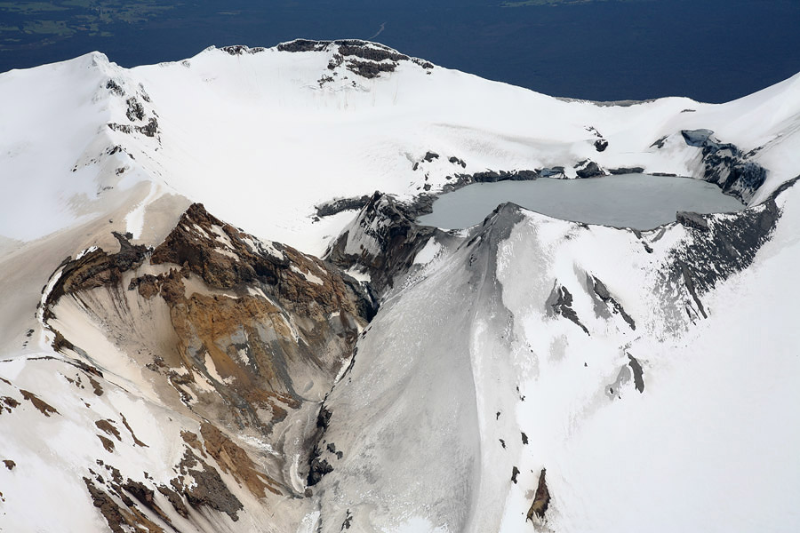
New Zealand , Ruapehu :
Mt Ruapehu crater lake temperature is now rising; volcanic activity remains at low level. Published: Tue Nov 3 2020 10:00 AM
Volcanic Alert Level remains at 1
Aviation Colour Code remains at Green
Recent data and observations from Mt Ruapehu crater lake (Te Wai ā-moe) indicates that the lake temperature is now rising and currently around 22°C. Volcanic activity at Mt Ruapehu remains low and the Volcanic Alert Level remains at Level 1.
Typically, over periods of months Ruapehu’s Crater Lake (Te Wai ā-moe) has heating and cooling cycles. In late September the lake had cooled to around 12 °C marking the low point of the cycle. Since mid-October the lake has been warming slowly and has now reached 22 °C. The lake is overflowing via the outlet. These are normal observations for the start of a heating cycle.

Chemical analysis of lake water collected on 9 October showed no significant changes in the makeup of the lake waters since the previous sample was collected on 9 August. The pH remains at 0.8, having ranged between 0.7 and 0.9 over the last 6 years. Other key chemical indicators such as the respective water concentrations in Mg (magnesium) and Cl (chloride) can be used to track whether the uprising fluids travel through new fractures or in the proximity of magma. These indicators have not varied significantly in the last 4-5 years. In other words, the lake water chemistry has largely remained chemically similar throughout this period.
Our interpretation of these observations is that the underlying vent areas are open to volcanic gases and geothermal fluids entering the lake and reacting with rock in the vents.
The intensity of volcanic tremor has remained weak over the past three months, and small earthquakes continue to be located in the vicinity of Mt Ruapehu.
None of these observations are unusual for Mt Ruapehu. All observations over the past months indicate that the volcano remains in a general state of minor unrest.
The Volcanic Alert Level remains at Level 1. The Volcanic Alert Level reflects the current level of volcanic activity and is not a forecast of future activity. Mt Ruapehu is an active volcano and has the potential to erupt with little or no warning when in a state of volcanic unrest. There is no change in the Aviation Colour Code and it remains at Green.
GNS Science and the National Geohazards Monitoring Centre continue to closely monitor volcanic activity at Mt Ruapehu with the GeoNet network of seismic and acoustic sensors, GPS receivers, sensors in the lake and visits to the lake area, and flights to collect and analyse volcanic gases.
Source : Geonet / Brad Scott , Duty Volcanologist .
Photos : Bradd Scott , Photovolcanica.
Indonesia , Sinabung :
VOLCANO OBSERVATORY NOTICE FOR AVIATION – VONA .
Issued : November 03 , 2020
Volcano : Sinabung (261080)
Current Aviation Colour Code : ORANGE
Previous Aviation Colour Code : orange
Source : Sinabung Volcano Observatory
Notice Number : 2020SIN26
Volcano Location : N 03 deg 10 min 12 sec E 98 deg 23 min 31 sec
Area : North Sumatra, Indonesia
Summit Elevation : 7872 FT (2460 M)
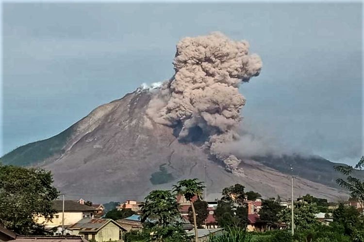
Volcanic Activity Summary :
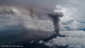
Eruption with volcanic ash cloud at 16:58 UTC (23:58 local). Eruption and ash emission is continuing .
Volcanic Cloud Height :
Best estimate of ash-cloud top is around 12672 FT (3960 M) above sea level, may be higher than what can be observed clearly. Source of height data: ground observer.
Other Volcanic Cloud Information :
Ash-cloud moving to east
Remarks :
Seismic activity is characterized by continuous volcanic tremor
Source : Magma Indonésie.
Photo : Peneliti Priatna PVMBG