September 30 , 2020.
La Réunion , Piton de la Fournaise :
Activity bulletin for Tuesday, September 29, 2020 at 2:45 p.m. (local time)
Recommended alert level: Alert 1
The seismic crisis that began on September 28, 2020 at 12:04 p.m. local time continues; even if a decrease in the number of earthquakes has been observed since the start of the day on 29/09.
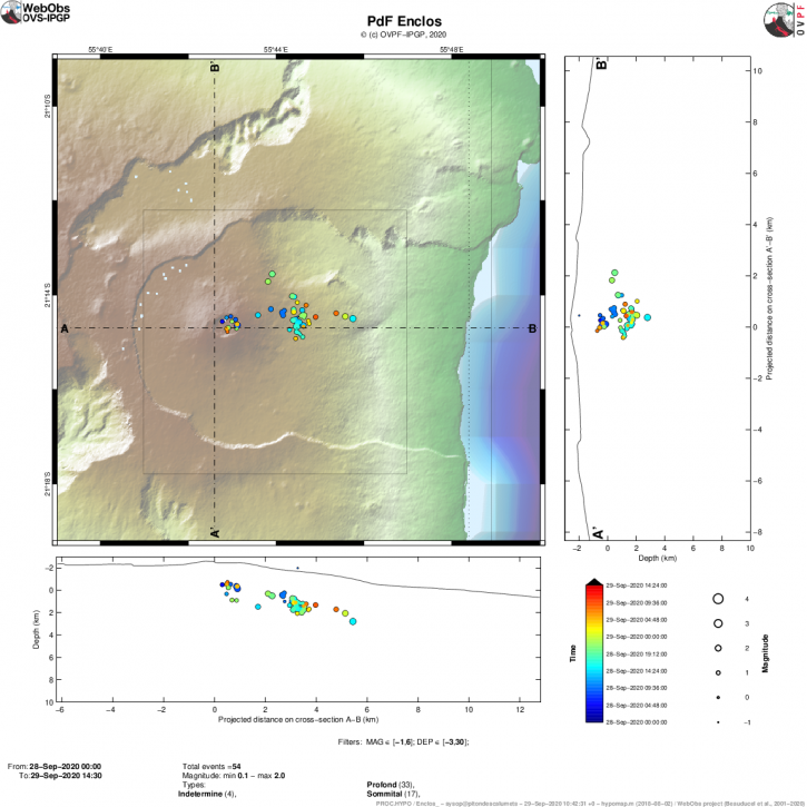
Figure 1: Location map (epicenters) and north-south and east-west sections (showing the location in depth, hypocenters) of earthquakes recorded and located by the OVPF-IPGP on 09/28/2020 on 09/29/2020 (2:30 p.m.) under the Piton de la Fournaise massif. Only localizable earthquakes have been shown on the map (© OVPF-IPGP).
Since the start of the crisis and up to 2:30 p.m. today, 2,235 earthquakes have been recorded by the OVPF. This seismicity is always located under the summit and under the eastern flank of the volcano (between 1.6 and 5.2 km deep).
Since the creation of the OVPF, 5 seismic crises have lasted longer than 24 hours (March 1986, June 1987, March 1998, January 2004 and April 2007) and have led for 3 of them to the opening of eruptive cracks at low altitude.
The risk of an eruption outside the enclosure, given the location of the activity, cannot be ruled out. The eruptive cracks, weakened by previous activities, could extend beyond the rampart. “We have no sign but the situation can change quickly. When an eruption starts, we have the risk out of the pen in mind. These areas are weakened because there are pre-fractures in 20 different places, ”says Aline Peltier, director of the OPVF. Since the creation of the observatory, only 5 seismic crises have lasted longer than 24 hours. « It is a rare event, we are at more than 30 hours of seismic activity without eruption (last night, editor’s note) and the record is between 40 and 50 hours »
Activity bulletin for Wednesday, September 30, 2020 at 10:30 a.m. (local time)
Recommended alert level: Alert 1
The seismic crisis that began on September 28, 2020 at 12:04 p.m. local time continues; even if a decrease in the number of earthquakes has been observed since the start of the day of 29/09 and even more clearly today.
Since the start of the crisis and up to 9:30 am today, 2,300 earthquakes and 442 shallow landslides / collapses have been recorded by the OVPF.
This seismicity is always located under the summit and under the eastern flank of the volcano (between 1.6 and 5.2 km deep; Figure 1).
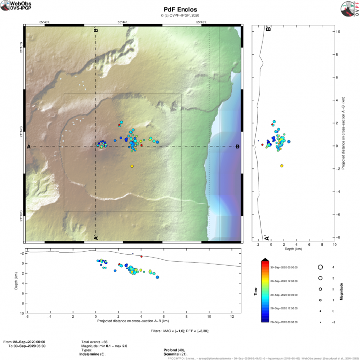
Figure 1: Location map (epicenters) and north-south and east-west sections (showing the location in depth, hypocenters) of the earthquakes recorded and located by the OVPF-IPGP between 28/09/2020 and 30/09 / 2020 (9:30 am) under the Piton de la Fournaise massif. Only localizable earthquakes have been shown on the map (© OVPF-IPGP).
During the day of 29/09, the deformations continued on the eastern flank of the volcano, thus the GPS station « GPNG » of the OVPF located in the upper part of the Grandes Pentes, at an altitude of 1414 m, has slipped east 50 cm, or 60 cm in total since the onset of the seizure, and has risen by about 20 cm since the start of the seizure (Figure 2).
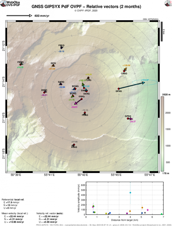
Figure 2: Ground movements (expressed in speed) recorded on the GPS stations inside and around the enclosure Fouqué. The horizontal displacements are represented in vector form and the vertical displacements are indicated by the numerical values in color. The ellipse represents the measurement error (© OVPF-IPGP).
At the level of the summit fumaroles, the seismic crisis is accompanied by a gradual decrease in both CO2 and SO2 (Figure 3), with fluids which again become mainly composed of water vapor, with very few other species. . This trend is compatible with a lateral magmatic transfer, far from the summit fumaroles, as illustrated by the seismicity and the deformations recorded since the start of the crisis.
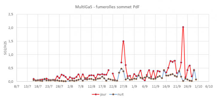
Figure 3: SO2 / H2S ratio recorded in the fumaroles in the summit area of Piton de la Fournaise since early July 2020.
Sources et photos : OVPF. Clicanoo.
Read the article : http://www.ipgp.fr/fr/ovpf/bulletin-dactivite-mercredi-30-septembre-2020-a-10h30-heure-locale
Italy / Sicily , Etna :
Weekly bulletin from September 21, 2020 to September 27, 2020, (issue date September 29, 2020)
SUMMARY OF THE STATE OF ACTIVITY
In the light of surveillance data, it is highlighted:
1) VOLCANOLOGICAL OBSERVATIONS: Variable strombolian activity with emission of ash at the New Southeast Crater; Strombolian activity within the deep crater at the Northeast Crater; isolated ash emissions at the Voragine crater; degassing activity at the Bocca Nuova
2) SEISMOLOGY: Considerable fracturing activity. Amplitude of the tremor between the average and high values.
3) INFRASON: Low infrasound activity.
4) DEFORMATIONS: During the last week, deformation transients have been observed both in the tilt network and in the GNSS network. Such short-lived transients are associated with observed activities, both volcanic and seismic. On the scale of the volcano, the chronological series do not show significant variations.
5) GEOCHEMISTRY: The flow of SO2 occurs at an average level.
HCl flux occurs at a medium-high level.
Soil CO2 flux values are at a low rate.
The partial pressure of dissolved CO2 does not show significant changes.
No update is available for the C / S report (last measurement of 07/17/2020).
The isotope ratio of helium is on average values (last update of 09/22/2020).
6) SATELLITE OBSERVATIONS: The thermal activity in the summit area is at a medium-high level.
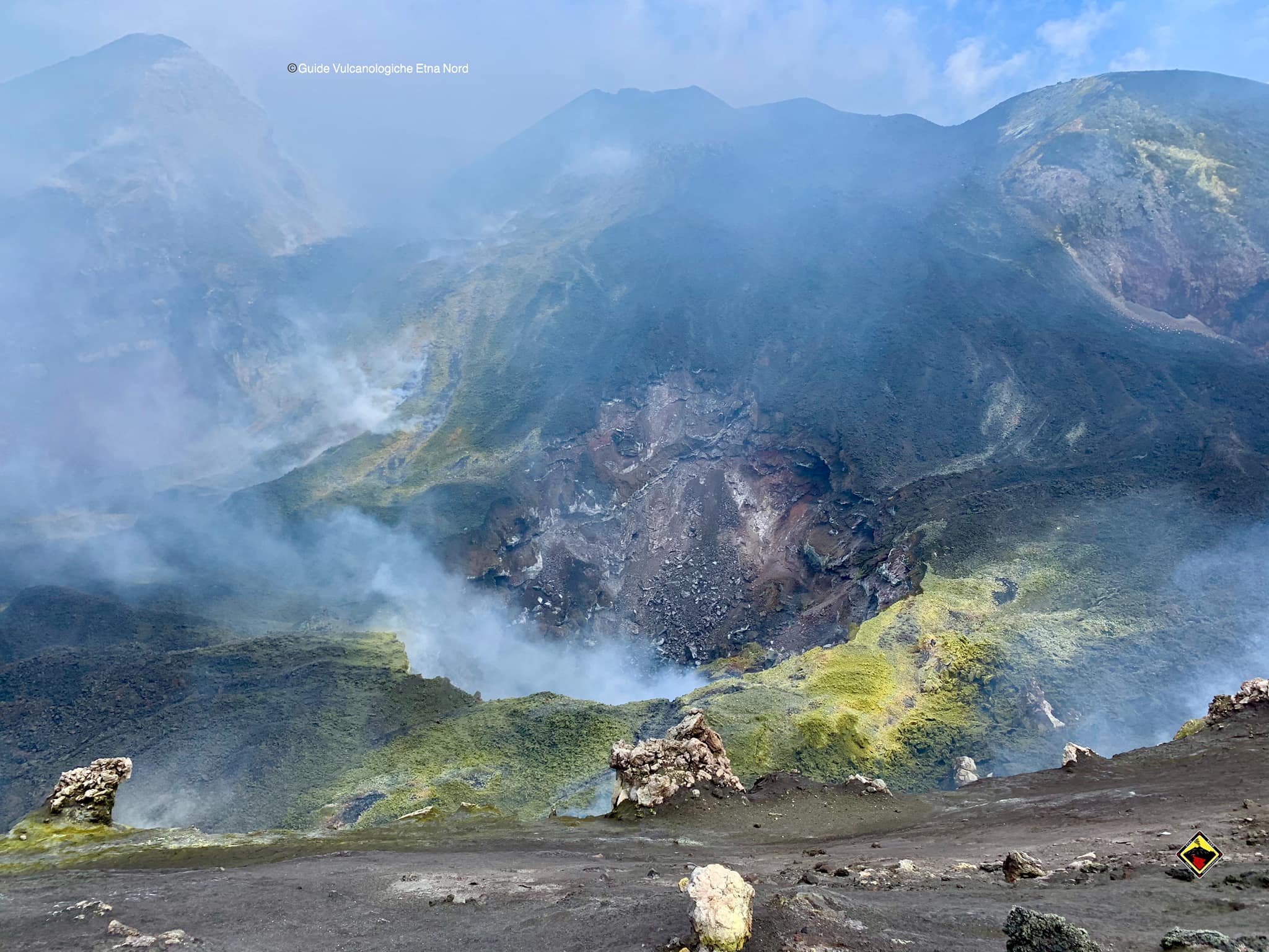
VOLCANOLOGICAL OBSERVATIONS
During the week, the monitoring of the volcanic activity at the level of the summit craters of Etna was carried out by analyzing the images of the network of surveillance cameras of the INGV section of Catania, Osservatorio Etneo (INGV-OE) and by inspections in the summit area on September 25 and 26 by INGV staff. The continuity in observing the activity during the week was partly limited due to weather conditions.
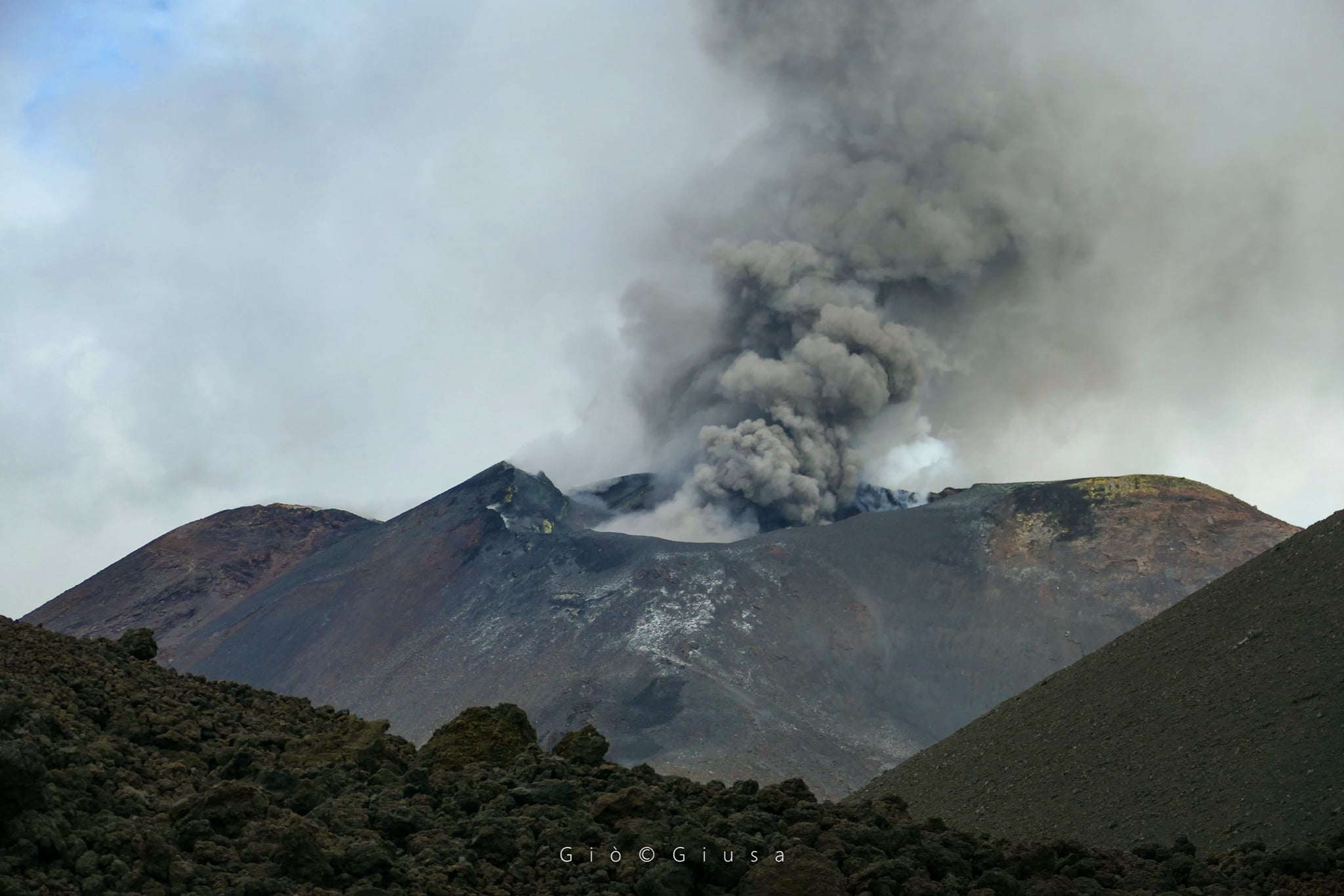
In detail, the New Southeast Crater was characterized by an explosive activity very variable in frequency and intensity which produced the launch of coarse pyroclastic material above the crater rim and the emission of ash with rapid dispersion at the neighborhood of the area. summit of the volcano. This September 26 activity increased in intensity, fueling an emission of volcanic ash that produced an eruptive cloud up to about 4.0 km above sea level which dispersed eastward. There have been no reports of a relapse of the ash in the inhabited centers of the eastern sector of Etna.
Regarding the Voragine, this crater was characterized by a degassing activity with isolated and light emissions of ash from the main slag cone, while the crater of Bocca Nuova (BN) exhibited a variable degassing regime from the collapse craters formed in April and the first days of September. Observations made during the inspection on September 25 showed that the September collapse crater area continues to be affected by slow and gradual widening. Finally, modest and deep Strombolian activity at the Northeast Crater continued during the week.
Volcanic tremor:
The amplitude of the tremor varies between medium and high levels, especially on the days of September 24 and 25. The sources of the tremor are located under the South-East and New South-East Craters, with depths close to the surface.
Source : INGV.
Photos : Guide Vulcanologiche Etna Nord , Gio Giusa .
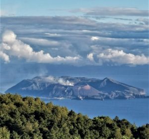
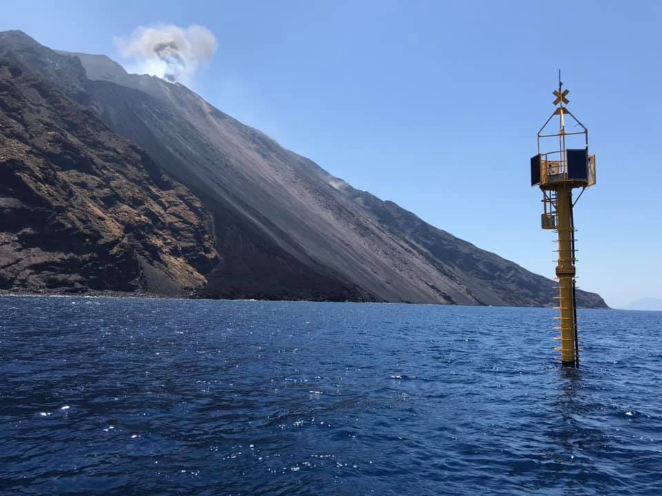
Italy , Stromboli :
Weekly bulletin from September 21, 2020 to September 27, 2020, (issue date September 29, 2020)
SUMMARY OF THE STATE OF ACTIVITY.
In the light of surveillance data, it is highlighted:
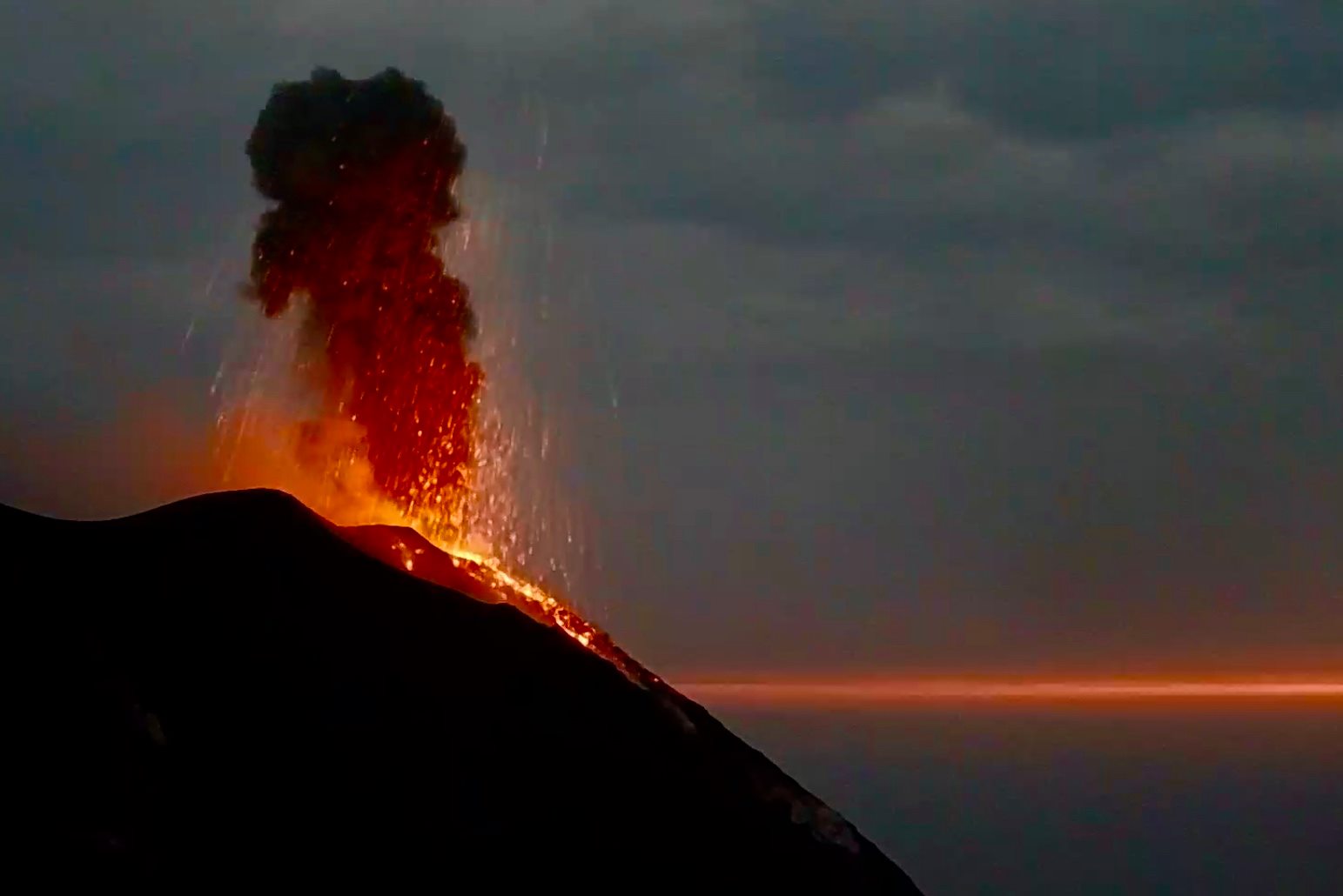
1) VOLCANOLOGICAL OBSERVATIONS: Normal explosive volcanic activity of Strombolian type on average levels (10-15 events / h) and medium-low intensity in the area of the North and medium-high craters in the Center-South area.
2) SEISMOLOGY: The seismological parameters do not show significant variations.
4) DEFORMATIONS: No significant variation is observed
5) GEOCHEMISTRY: Medium-low SO2 flux.
There are no updates on the soil CO2 flux data.
C / S Ratio – Data not available. The latest values are at medium-low levels (5.45, measurements of 09/13/2020).
Helium isotope ratio – The latest measurements (09/22/2020) are average values.
6) SATELLITE OBSERVATIONS: The thermal activity in the summit area is at a medium-low level.
VOLCANOLOGICAL OBSERVATIONS
In the period under observation, the eruptive activity of Stromboli was characterized by the analysis of the images recorded by the surveillance cameras INGV-OE located at 190 m, Punta dei Corvi and 400 m. The Pizzo camera, damaged during the event of July 19, 2020, is being restored in the INGV-OE laboratories.
In the area of the North crater, the N1 crater, with three emission points, produced explosions of low to medium intensity (less than 150 m high), emitting coarse materials (lapilli and bombs). The N2 vent showed mainly low intensity explosive activity (less than 80 m in height) emitting coarse materials. The average frequency of the explosions varied from 6 to 13 events / h.
In the Center-South zone, the explosions emitted mainly fine materials sometimes mixed with coarse materials, with a medium-high intensity (the products emitted often exceeded 250 m in height).
The frequency of the explosions varied from 1 to 8 events / h.
The amplitude of the volcanic tremor generally had values between low and medium-low.
Source : INGV .
Photos : Webcam , LGS.
Ecuador , Reventador :
DAILY REPORT OF THE STATE OF THE REVENTADOR VOLCANO, Tuesday September 29, 2020.
Information Geophysical Institute – EPN.
Surface activity level: High, Surface trend: Increasing.
Internal activity level: High, Internal trend: No change.
Seismicity: From September 28, 2020, 11:00 a.m. to September 29, 2020, 11:00 a.m.
Explosions (EXP): 76 events
Rains / lahars: Today in the morning several episodes of rains were recorded in the area, without the descent of lahars having been reported.
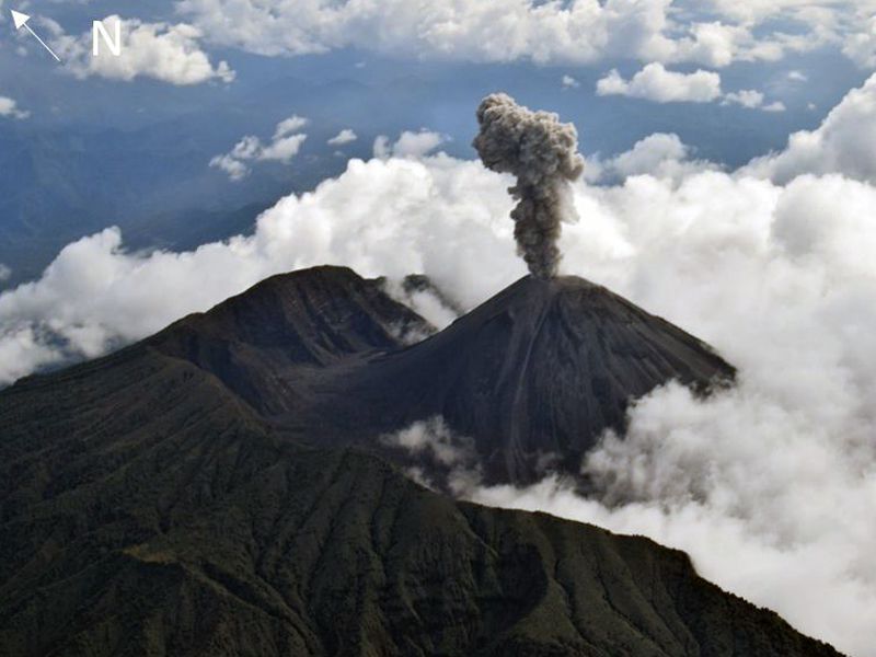
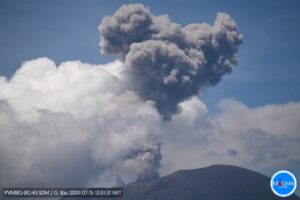
Emission / ash column: Gas and ash emissions were observed which reached heights of 1000 meters above crater level, in a westerly direction. The Washington VAAC published 1 emission report observed by the satellites, with a northwest direction and an altitude less than 1000 meters above the crater level.
Other monitoring parameters: No changes were recorded.
Observations: Since night until today, sometimes with the volcano cleared, described emissions have been observed. At night, an incandescence was observed in the crater as well as the rolling of blocks on the southwest flank up to 600 meters below the level of the crater. The lava flow is still active (~ 400m) on the northeast flank. The seismic statistics were carried out at the CASC station located in Dorado de Cascales, about 42 km from the Reventador volcano (Read the statement: http://ow.ly/IB0C30r51gd).
Alert level: Orange.
Source : IGEPN.
Photo : f-naranjo , GVP.