September 11 , 2020.
Russia / Kurile Islands , Ebeko :
VOLCANO OBSERVATORY NOTICE FOR AVIATION (VONA).
Issued: September 10 , 2020
Volcano: Ebeko (CAVW #290380)
Current aviation colour code: ORANGE
Previous aviation colour code: orange
Source: KVERT
Notice Number: 2020-179
Volcano Location: N 50 deg 41 min E 156 deg 0 min
Area: Northern Kuriles, Russia
Summit Elevation: 3791.68 ft (1156 m)
Volcanic Activity Summary:
A moderate eruptive activity of the volcano continues. According to visual data by volcanologists from Severo-Kurilsk, explosions sent ash up to 3.0 km a.s.l., an ash cloud is drifting to the south-east of the volcano.
This eruptive activity continues. Ash explosions up to 19,700 ft (6 km) a.s.l. could occur at any time. Ongoing activity could affect low-flying aircraft and airport of Severo-Kurilsk.
Volcanic cloud height:
8200-9840 ft (2500-3000 m) AMSL Time and method of ash plume/cloud height determination: 20200910/2318Z – Visual data
Other volcanic cloud information:
Distance of ash plume/cloud of the volcano: 2 mi (3 km)
Direction of drift of ash plume/cloud of the volcano: SE
Time and method of ash plume/cloud determination: 20200910/2318Z – Visual data
Source : Kvert .
Photo : Yuri Demyanchuk.
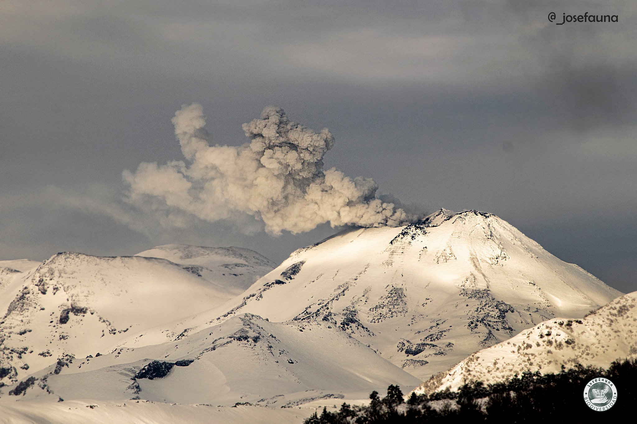
Argentina / Chile , Nevados of Chillan :
Seismicity parameters associated with both rigid material fracturing (VT) processes and fluid dynamics within the volcanic complex (LP and TR types) or surface activity (EX) have remained at levels similar to the last periods.
The highest energy VT event, with a local magnitude (ML) of 3.8, was located 8.1 km northeast (NE) of the active crater and at a depth of 3.9 km .
The images provided by the surveillance cameras enabled us to observe that the dynamics of effusive and explosive activity continued during this fortnight. The effusive activity is characterized by the extrusion of lava, which accumulates at the level of the crater and advances outside the northern limit of the active crater, generating a flow which to date reaches 495 m from the edge of it. .
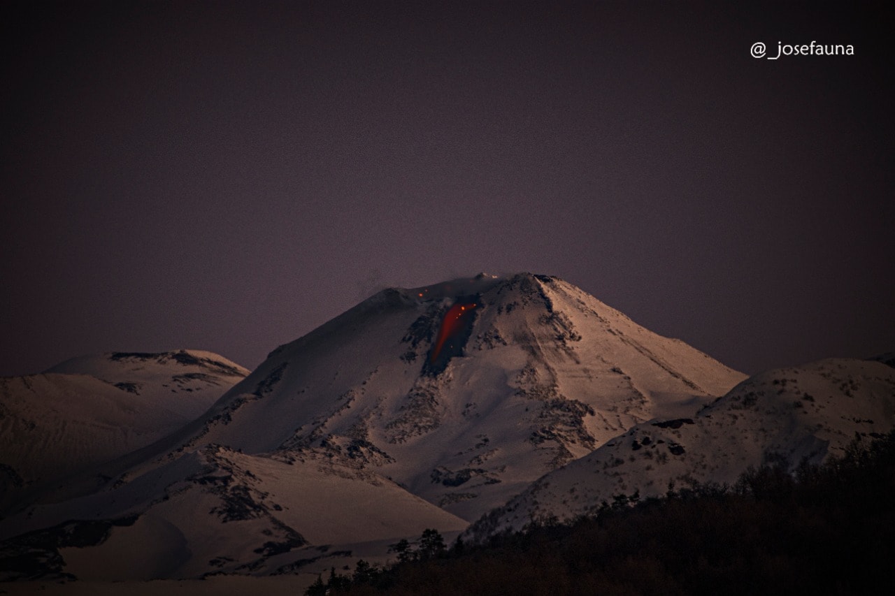
The explosive activity presented column heights less than 980 m, with a moderate content of particles and a higher content of volcanic gases. When weather conditions permitted, it was possible to record incandescence day and night.
According to the data obtained from the network of GNSS stations and inclinometers installed on the volcano, minor variations are observed, linked to increases and decreases in pressure inside the volcano, values that do not imply l ‘recording of permanent or accumulated deformations.
5 thermal alerts were recorded in the area with a maximum value of 5 MW, a value considered low.
The affected area is considered the closest to the crater with a radius of 5 km.
Recommendations:
Stay informed of the activity level of the volcano.
Receive information only from official media.
The yellow technical alert level implies the occurrence of changes in the behavior of the activity of the volcano.
CONCLUSIONS
The eruptive cycle of the Nevados de Chillán volcanic complex continues to evolve regularly, with the advance of the lava flow observed on the northern slope, added to the location of a new lava dome housed in the crater, corroborated by satellite images.
Additionally, data from GNSS stations showed some minor downward variations during this period. However, the recording of seismicity associated with the dynamics of fluids and explosions, thermal alerts, and recording of degassing and incandescence at low height are consistent with the development of this type of surface magmatic body.
The recording of a new source of volcano-tectonic seismicity, located 8 km northwest of the active crater, stands out for the period.
Although the current process is considered to be part of an intermittent eruptive dynamic with emission of magmatic material towards the surface and with a low level of explosiveness, an untimely escalation of internal activity is not excluded.
Source : Segemar .
Photos : Josefauna.
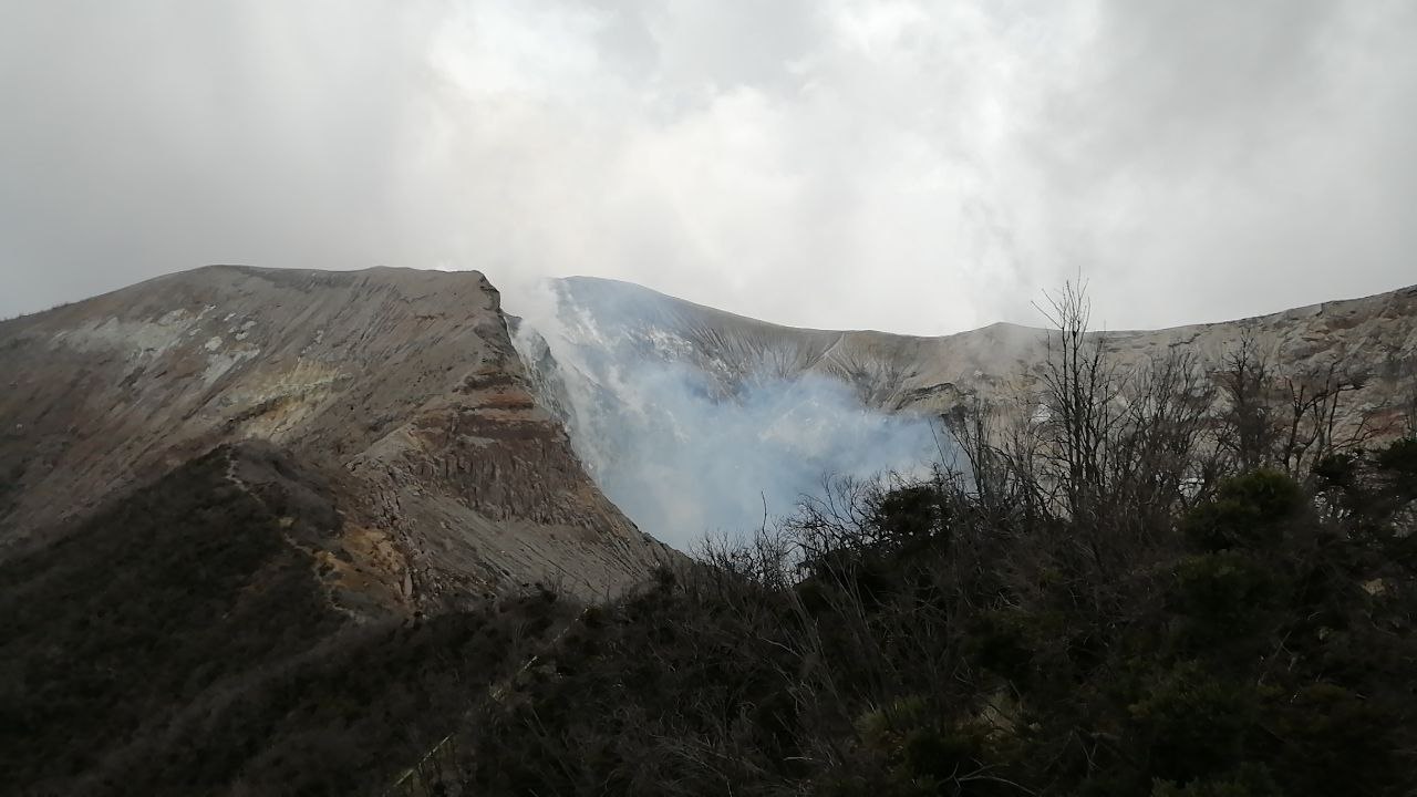
Costa Rica , Turrialba / Poas / Rincon de la Vieja / Irazu / Arenal :
Turrialba volcano
Lat: 10.025 ° N; Long: 83.767 ° W;
Altitude: 3340 m.s.n.m.
Current activity level: 2 (active volcano)
Potentially associated hazards: gas, ash emission, proximal ballistic projections.
No ash emission was observed. The seismic activity is stable, only low frequency volcanic earthquakes have been recorded. The contraction and subsidence of the Turrialba-Irazú massif continues. The CO2 / SO2 and H2S / SO2 ratios are stable. The flow of SO2 remains low (~ 100 t / day) with a slight upward trend. No thermal anomaly was detected by the MODIS analysis.
Poas volcano
Lat: 10.2 ° N; Long: 84.233 ° W;
Altitude: 2780 m.s.n.m.
Current activity level: 2 (active volcano)
Potentially associated hazards: gas, phreatic eruptions, proximal ballistic projections.
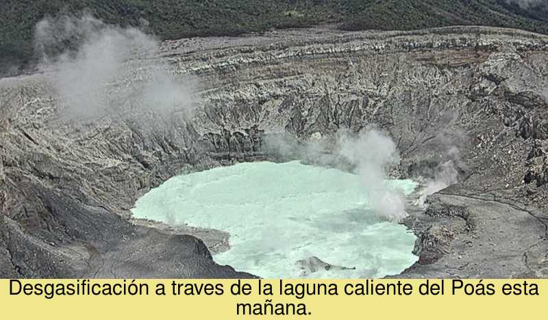
No eruption was detected. The number of LP type events continues to fluctuate. There is no significant deformation. The SO2 / CO2 ratio remains variable, the H2S / SO2 ratio remains stable. The SO2 flow remains low with values lower than 50 t / day. The level of the lake decreased slightly during the week.
Rincon de la Vieja volcano
Lat: 10.83 ° N; Long: 85.324 ° W;
Altitude: 1895 m.s.n.m.
Current activity level: 3 (erupting volcano)
Potentially associated hazards: gas, phreatic eruptions, proximal ballistic projections, lahars.

Several low energy phreatic eruptions have been recorded. The RSAM fell to a similar level at the start of the year, but the tremor returned on September 6. Low frequency tremors are unstable in frequency of occurrence and duration, and there are few VT-type events. ICE volcanologists observed significant convective activity in the lake on September 2, but the eruptions are deep. There is no significant deformation. No thermal anomaly was detected by the MODIS analysis.
A very weak hydrothermal activity is recorded associated with degassing through fumaroles and small bubbles of gas and vapor emerging from the bottom of the lake. Seismicity is dominated by infrequent low frequency volcanic earthquakes and very low amplitude intermittent tremor. The deformation does not show significant changes. The temperatures and heat flow in the Sensoria water point remain stable.
Irazu volcano
Lat: 9.979 ° N; Long: 83.852 ° W;
Altitude: 3432 m.s.n.m.
Current activity level: 1 (active)
Potentially associated hazards: landslides.
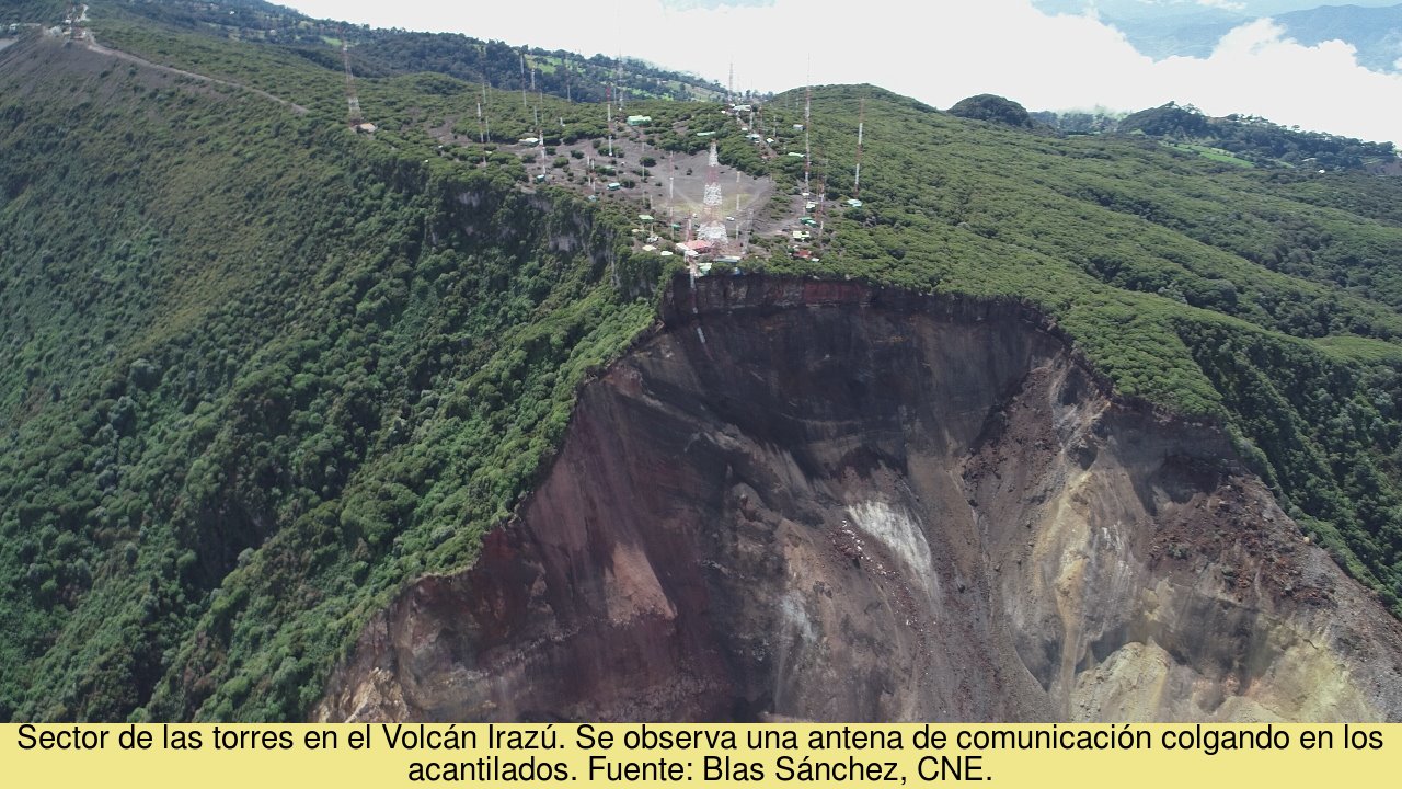
The concentration of CO2 in the North zone is stable. The number of landslides recorded by the OVSICORI seismic network has remained low since the main rupture of August 26 and they ceased to be recorded last Friday. The GPS network shows acceleration in the western part of the communications tower area.
Arenal volcano
Lat: 10.463 ° N; Long: 84.703 ° W;
Altitude: 1670m
Current activity level: 0 (asleep)
Potentially associated hazards: earthquakes, landslides.
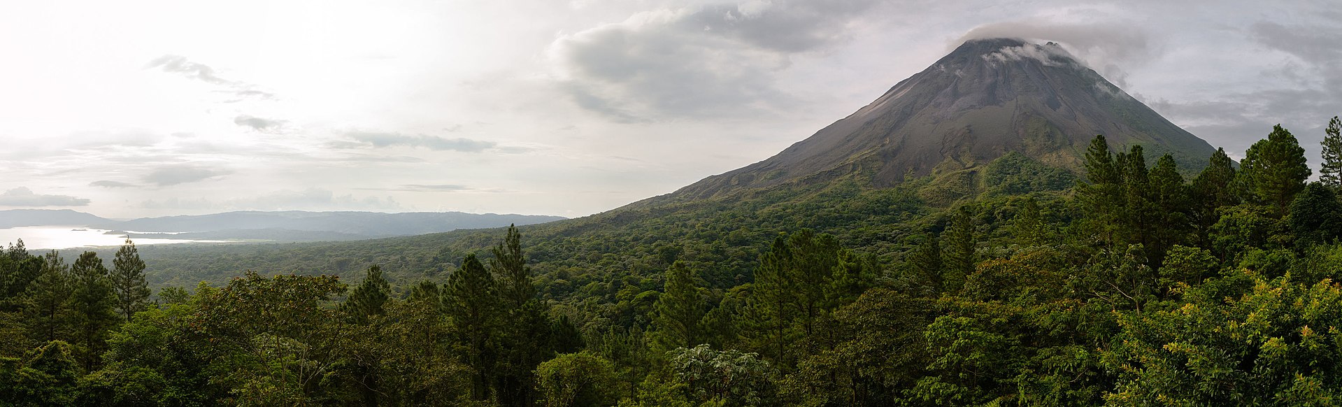
No significant deformation is detected. The MODIS analysis (on board the Terra and Aqua satellites) detected a small thermal anomaly on September 5. The last detection of a thermal anomaly by the same methodology took place at the end of September 2019.
Source : Ovsicori .
Photos : Jean Paul Calvo /RSN , ovsicori , Blas Sanchez / CNE , Christophe Meneboeuf (wikipedia ).
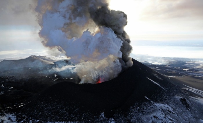
Ecuador , Reventador :
DAILY REPORT OF THE STATE OF THE REVENTADOR VOLCANO, Sunday 06 September 2020.
Information Geophysical Institute – EPN.
Surface activity level: High, Surface trend: Increasing.
Internal activity level: High, Internal trend: No change.
Seismicity: From September 09, 2020, 11:00 a.m. to September 10, 2020, 11:00 a.m.
Explosions (EXP): 56 events
Rains / lahars: Not recorded.
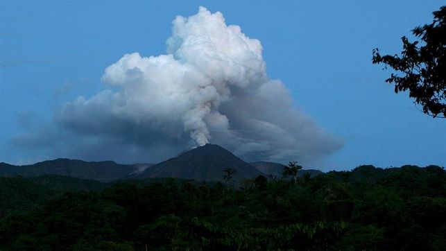
Emission / ash column: Several gas and ash emissions were observed reaching heights of 400 to 900 meters above the crater level. Their direction varied from North to North-West. There have been 3 VAAC alerts of emissions observed by satellites reaching heights of about 1000 meters above crater level, with a constant direction to the northwest.
Other monitoring parameters: FIRMS has logged 7 thermal alerts on the Reventador in the last 24 hours
Observations: In general, from the night until the close of this bulletin, the volcano was mostly clear, allowing to observe the emissions already described. At night, an incandescence was observed in the crater as well as rolling of incandescent blocks on the northern flank. The lava flow is still active (~ 400 m) in the northeast.
The seismic statistics were carried out at the CASC station located in Dorado de Cascales, about 42 km from the Reventador volcano.
(read the statement: http://ow.ly/IB0C30r51gd).
Alert level: Orange.
Source : IGEPN.
Photo : EDIIMA