October 12 , 2021
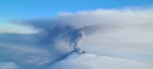
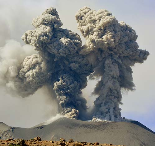
Hawaii , Kilauea :
19°25’16 » N 155°17’13 » W,
Summit Elevation 4091 ft (1247 m)
Current Volcano Alert Level: WATCH
Current Aviation Color Code: ORANGE
Activity Summary:
Kīlauea volcano is erupting. As of this morning, October 11, 2021, lava continues to erupt from a single vent in the western wall of Halemaʻumaʻu crater. All lava activity is confined within Halemaʻumaʻu crater in Hawai‘i Volcanoes National Park. Seismicity and volcanic gas emission rates remain elevated.
Summit Observations:
Sulfur dioxide (SO2) emission rates remain high, with a measured emission rate of approximately 5,300 tonnes per day on October 8, 2021, similar to the measurements of the last few days. Seismicity remains elevated but stable. Summit tilt has changed to a slightly inflationary trend since the morning of October 10.
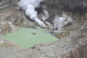
Halemaʻumaʻu Lava Lake Observations:
Lava continues to erupt from a single vent in the western wall of Halemaʻumaʻu crater. The western end of the lake showed a maximum elevation of approximately 781 meters (2562 ft) above sea level when measured by field crews on October 10, which is a 1 meter (3 ft) increase over the past day and a total increase of about 38 meters (125 ft) since lava emerged on September 29. The total erupted volume since the beginning of the eruption was estimated to be about 15.9 million cubic meters (4.2 billion gallons) on October 8. The lava fountain of the western vent has a sustained height of about 4 meters (13 ft) decreasing from about 15 meters (49 ft) in the previous days.
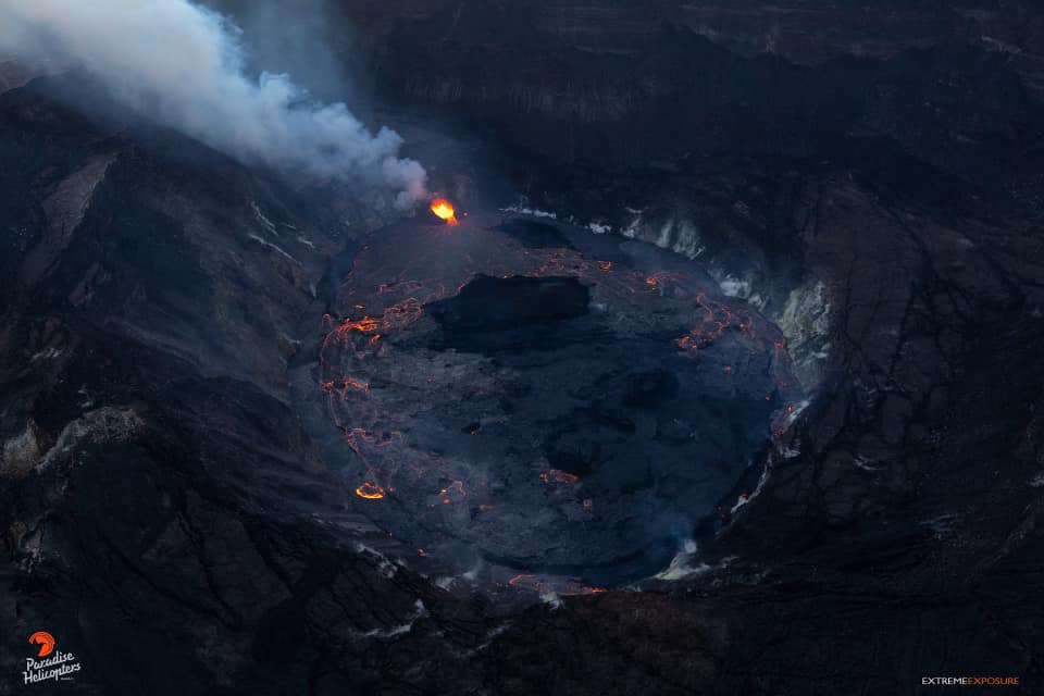
The fountain has built a spatter cone with an approximately 10 meter (33 ft) wide opening facing east towards the lake. Lava is flowing into the lake through the spatter cone opening. The central island and several of the smaller eastern islets from the 2020 lava lake are still above the lake surface along with an island of the 2020 western vent rampart in the northwest part of the lake. The lava lake is not level across its surface due to the location of the vent in the western end. Areas closer to the vent are about 2-3 meters (7-10 ft) higher in elevation compared to the north and south part of the lake and 5 meters (16 ft) higher than the east end of the lava lake. Lava surface activity such as crustal foundering is seen on the western end of the lake and north and south of the central island but is no longer observed on the east end of the lake.
Source : HVO
Photos : Bruce Omori.
Spain / La Palma , Cumbre Vieja :
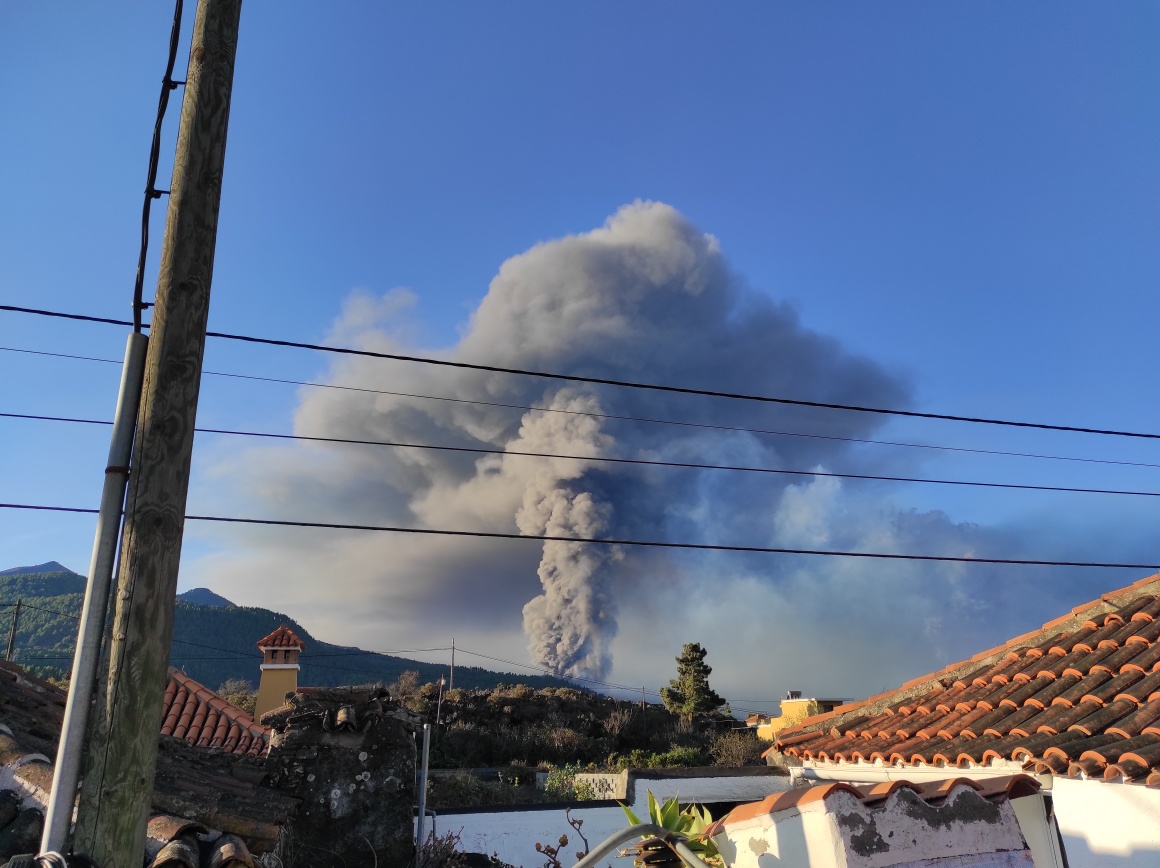
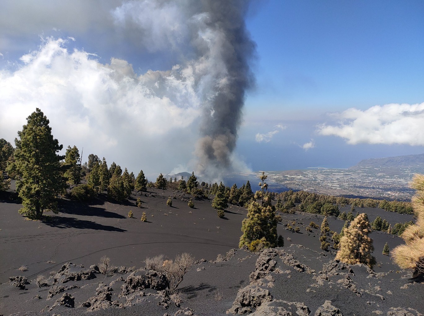
October 11, 2021 10:00 UTC, Eruptive activity continues on La Palma.
Since the last declaration, 108 earthquakes have been located in the area affected by the volcanic reactivation of Cumbre Vieja, 7 of these earthquakes were felt by the population, the maximum intensity being in the epicentral zone III-IV ( EMS98), with an event that occurred at 21:46 UTC on the 10th, with a magnitude of 4.3 (mbLg) at a depth of 38 km. This earthquake is the largest since the last declaration.
Among the earthquakes located in this period, 14 are at depths greater than 30 km, the rest of the hypocenters are located at a shallower depth, about 12 km.
The average amplitude of the volcanic tremor remains stable within a range of average values compared to the observations measured during this eruption.
The height of the column measured at 6.30 UTC is 4000 m.
The island’s network of permanent GNSS stations shows stability at stations close to eruptive centers. These results are compatible with those obtained by InSAR, in which no distortion is observed between the Sentinel1 images of October 4 and 10.
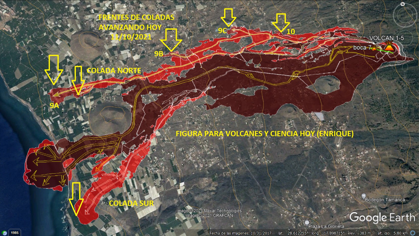
New containments on the island of La Palma after the arrival of the lava flow in industrial areas. The slow but inexorable advance of lava towards factories and cement plants generated toxic gases that forced the Canary Islands Volcanic Emergency Plan (Pevolca), the crisis committee managing the eruption, to take this action to the third time since the eruption. The containment affects a polygon-shaped area that includes various localities in El Paso and Los Llanos de Aridane where between 2,500 and 3,000 people live, according to spokesman Miguel Angel Morcuende. The Cabildo de La Palma, in addition, has since Monday prohibited access by Tazacorte to evacuated areas until the evolution of the volcanic emergency north of the mountain of Todoque is studied.
The eruption is always fed by the magma which comes from the chamber or the area where the seismic swarm is located which remains hanging 10-14 km deep under the island and which is fed deeper and deeper by a another area or reservoir that produces the most seismicity about 35-40 km from where the magma is rising. The deformation indicates that the magma is moving towards the west of the island in depth, towards the eruption zone.
The constant effusive activity widened the flows northward, continuing their descent towards the Todoque area, which had not been affected by the main flow.
Thus, there are currently two branches in the North flow: the South one, which joined the previous flow, and the North one, which is in the industrial area of Los Llanos de Aridane.
The latter is the subject of particular vigilance against the possibility that its course may vary.
According to the European Copernicus service, 1,281 buildings are affected. Regarding the area of crops, the damaged hectares amount to 132.
Source : IGN , El Pais .
Photos : Volcanes de Canarias , Volcanes y Ciencia Hoy , Il Mondo dei Terremoti .
Peru , Sabancaya :
Analysis period: from October 04, 2021 to October 10, 2021, Arequipa, October 11, 2021.
Alert level: ORANGE
The Geophysical Institute of Peru (IGP) reports that the eruptive activity of the Sabancaya volcano remains at moderate levels, that is to say with the recording of an average of 27 daily explosions, with columns of ash and gas up to 2 km altitude above the summit of the volcano and their consequent dispersion. Therefore, for the following days, no significant change is expected in eruptive activity.
The IGP recorded and analyzed the occurrence of 754 earthquakes of volcanic origin, associated with the circulation of magmatic fluids within the Sabancaya volcano. An average of 27 explosions was recorded daily. During this period, Volcano-Tectonic (VT) earthquakes associated with rock fractures were located mainly in the North-East and North of Sabancaya and presented magnitudes below M3.5.
The monitoring of the deformation of the volcanic structure using GNSS techniques (processed with fast orbits) does not present any significant anomalies. However, in general, an inflation process was observed in the northern sector (around the Hualca Hualca volcano). Visual surveillance made it possible to identify columns of gas and ash up to 2 km altitude above the summit of the volcano, which were scattered towards the West, South, South-East, North-West and East sectors of the volcano. Sabancaya. Satellite recordings identified the presence of 1 thermal anomalies (maximum value of 3 MW) associated with the presence of a lava body on the surface of the volcano’s crater.
RECOMMENDATIONS
• Keep the volcanic alert level in orange.
• Do not approach within a radius of 12 km from the crater.
Source et photo : IGP.
Colombia , Nevado del Ruiz :
On the morning of last Sunday, the Colombian Geological Service published a bulletin on the increase in ash emissions and the activity that the Nevado del Ruíz volcano presented, a situation that raised alarms in neighboring towns.
A column of water vapor and gas was observed today in the morning thanks to the cameras installed by the SGC – Manizales in the area of the Nevado del Ruiz volcano. The gas column reached a maximum height of 1050 m with a northeast direction of dispersion. The level of activity of the Nevado del Ruiz volcano continues at the yellow activity level (III) changes in the behavior of volcanic activity.
« There is constant communication with the municipalities in the area of influence of this volcano, in particular with the four municipalities mentioned in the press release (Villahermosa, Líbano, Murillo, Casabianca) », indicated the Departmental Secretariat for Risk Management.
During the surveillance, a report was received from the municipality of Herveo, indicating the presence of ash falls and with whom there is constant communication, the authorities added.
The Tolima governorate said it is in direct communication with staff assigned by the geological service, which provides detailed information on the activity of the volcano.
« The call is for calm and to receive the information issued by the Colombian Geological Service, through its official pages and sent from the governorate of Tolima, » they stressed.
Sources : Elnuevodia. Ingeominas.
Photo : Diana M Bustamante.
Guatemala , Santiaguito :
Activity:
The observatory of the Santiaguito volcano OVSAN reports a scattered degassing at the level of the crater which disperses in a southwest direction. Weak to moderate explosions were recorded which expel white / gray columns at a height of 3,400 meters above sea level (11,155 feet) which are scattered to the west and southwest. The volcano continues to generate constant avalanches of boulders and ash, with weak, moderate and some strong importance on the western, southwest and southern flanks, some reaching the base of Dome Caliente.

It is possible to hear faint degassing noises similar to an airplane turbine, due to the pressure of the magmatic gases. Fine material is observed in suspension in the volcanic perimeter due to the uplift of material during avalanches and explosions of the Santiaguito volcano. Due to the extrusion of block lava from the Caliente Dome in a West-South-West direction and unstable materials in the crater, there is a likelihood of moderate to heavy pyroclastic flows, so do not stay near or in the channels of the rivers near the slopes of the volcano.
Source : Insivumeh
Photo : Annie Winson , earthobservatory.sg