
March 29 , 2022.
Colombia , Nevado del Ruiz :
Subject: Activity of the Nevado del Ruiz volcano. The level of activity is maintained at the Yellow level or (III): changes in the behavior of volcanic activity.
Regarding the monitoring of the activity of the Nevado del Ruiz volcano, the COLOMBIAN GEOLOGICAL SERVICE reports that:
From today March 27, 2022 at 10:04 a.m. (local time), until the time of publication of this bulletin, there has been a significant increase in seismo-volcano-tectonic activity, associated with the fracturing of the rock inside the volcanic edifice, located in the northern sector of the volcanic edifice at an average distance of 1.9 km, compared to the Arenas crater. A volcano-tectonic earthquake that occurred at 5:24 p.m. (local time) with a magnitude of 3.4 ML (local magnitude) at 3.8 km depth, not reported as felt and published in the earthquake portal land from the Colombian Geological Service (https://www.sgc.gov.co/sismos).
The other monitoring parameters of the volcano do not show significant changes.
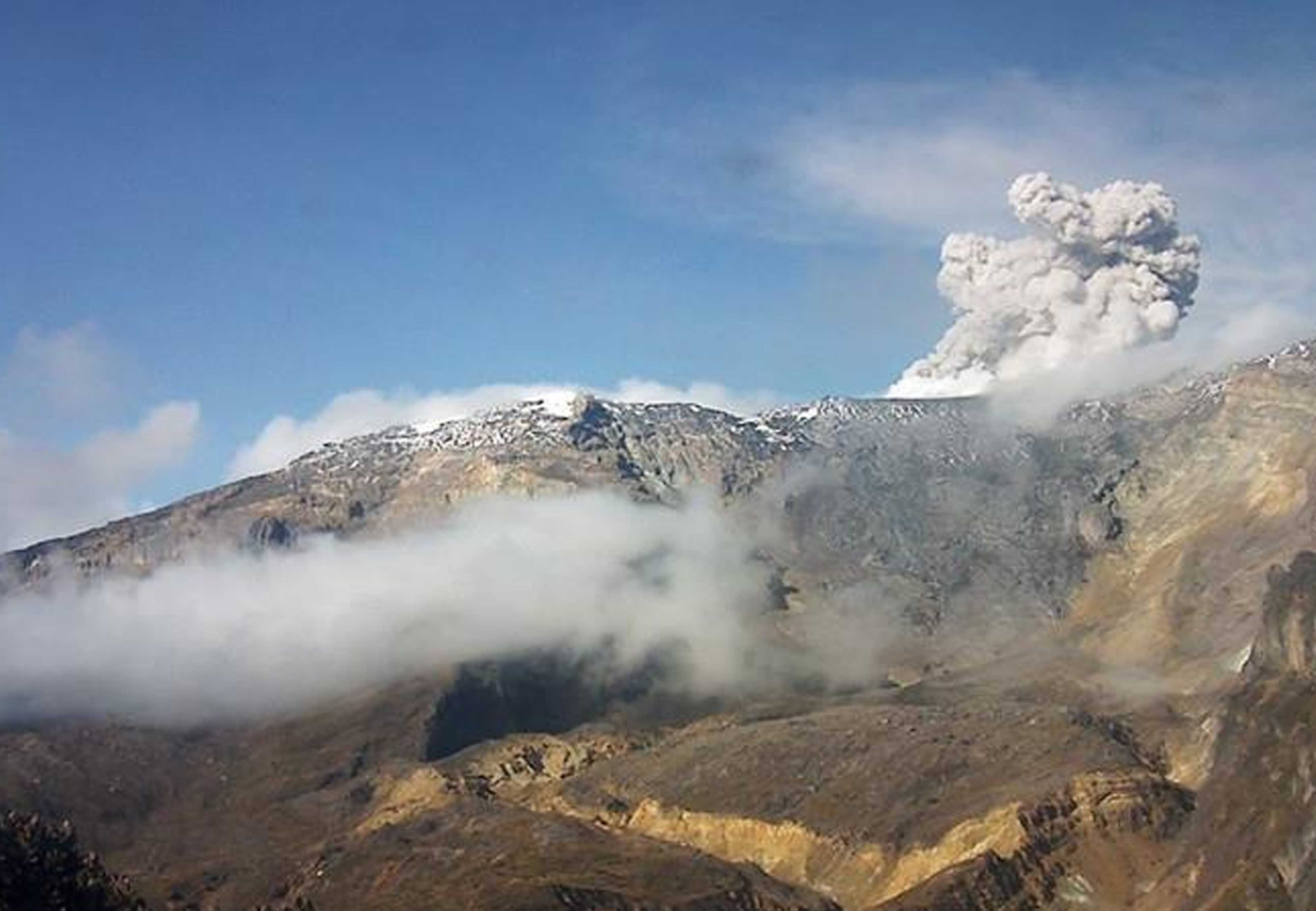
The Nevado del Ruiz volcano continues at the yellow activity level. It is not excluded that an activity can occur which could indicate an acceleration of the process, implying a greater instability of the volcano and consequently changes in its level of activity. Although the instability of the volcano has lasted for eleven years, it is essential not to get used to its behavior and to be attentive to the official information that will be published by the Colombian Geological Service. The authorities of the departments of Caldas and Tolima are urged to take extreme measures focusing on both risk reduction processes and disaster management as preparedness measures for the future activity of the Nevado del Ruiz volcano.
It is recommended that the community continue to be alert to any changes that occur in the activity of the volcano.
The COLOMBIAN GEOLOGICAL SERVICE remains attentive to the evolution of the volcanic phenomenon and will continue to report any changes that may occur in a timely manner.
Source : SGC.
Photo : Parque-Nevado-del-Ruiz.
Peru , Sabancaya :
Analysis period: from March 21, 2022 to March 27, 2022, Arequipa, March 28, 2022.
Alert level: ORANGE
The Geophysical Institute of Peru (IGP) reports that the eruptive activity of the Sabancaya volcano remains at moderate levels, that is to say with the recording of an average of 29 daily explosions, with columns of ash and of gas up to 2.2 km altitude above the summit of the volcano and their subsequent dispersion. Therefore, for the following days, no significant change is expected in eruptive activity.
The IGP recorded and analyzed the occurrence of 163 earthquakes of volcanic origin, associated with the circulation of magmatic fluids inside the Sabancaya volcano. An average of 29 explosions was recorded daily. During this period, there was no record of Volcano-Tectonic (VT) type events associated with rock fracturing within the Sabancaya volcano.
Monitoring the deformation of the volcanic structure using GNSS techniques (processed with fast orbits) does not show any significant anomalies. However, in general, an inflation process was observed in the northern sector (surroundings of the Hualca Hualca volcano). Visual surveillance identified columns of gas and ash up to 2.2 km above the summit of the volcano, which were dispersed to the south-west, south, south-east and east sectors of the volcano. Sabancaya. Satellite recordings have identified the presence of 7 thermal anomalies, with a maximum value of 30 MW, associated with the presence of a lava body on the surface of the volcano’s crater.
RECOMMENDATIONS
• Keep the volcanic alert level orange.
• Do not approach within a radius of less than 12 km from the crater.
Source : CENVUL
Photo : Galeria del Ministerio de Defensa del Perú.
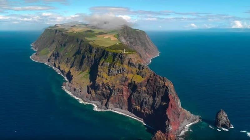
Azores , São Jorge :
Since March 19, the island of São Jorge in the Azores archipelago has been hit by a seismic swarm that has registered more than 400 earthquakes with a magnitude of up to 3.3 according to information provided by the Azores Seismo-Volcanic Monitoring and Information Center (CIVISA). In the initial phase of this recent seismic swarm, it was questioned whether the earthquakes had a volcanic or tectonic origin, given that the Azores archipelago is a volcanic and tectonically active region.
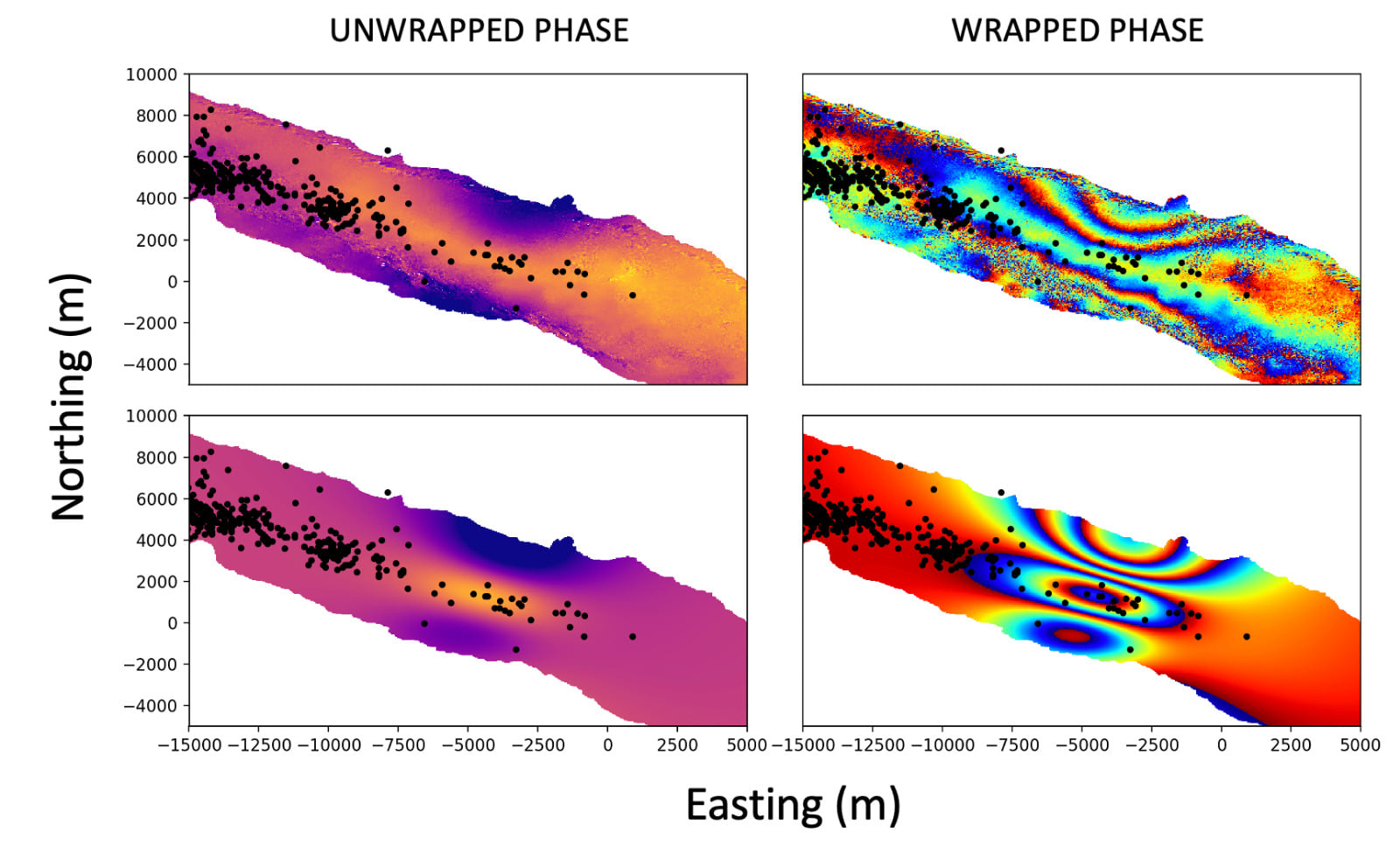
The Volcanological Institute of the Canary Islands (INVOLCAN), thanks to the analysis of synthetic aperture radar data acquired by the Sentinel-1 satellite of the European Space Agency, has been able to observe that in recent weeks the said island has suffered a deformation of the terrain consistent with a source of volcanic nature. In concrete terms, a technique known as “satellite interferometry” was used, which compares the radar images obtained at two different dates to detect phase variations which could be associated with deformations of the relief of the earth’s surface.
The figure shows the observed data and the synthetic model for a magmatic intrusion along a subvertical fracture (dyke). The estimated volume for said intrusion is around 20 million m3, a value comparable to what was observed by ground deformation before the Cumbre Vieja eruption in 2021.
This activity was possible thanks to the VOLRISKMAC II project (MAC2/3.5b/328) co-funded by the INTERREG V-A Spain-Portugal MAC Cooperation Program 2014-2020.
Earthquakes felt on the island of São Jorge (State point, March 28, 2022, 22:00).
The Azores Seismo-Volcanic Information and Monitoring Center (CIVISA) reports that seismic activity has been recorded since 4:05 p.m. (local time = UTC-1) on March 19 in the central part of the island of São Jorge, more precisely along a line oriented WNW-ESE, in a sector between Velas and Fajã do Ouvidor. This continues above normal. The strongest earthquake occurred on March 19 at 6:41 p.m. (local time = UTC-1) and had a magnitude of 3.3 (Richter).
So far, about 208 earthquakes felt by the population have been recorded. From 10:00 a.m. to 10:00 p.m. on March 28, 1 earthquake was felt, of magnitude 1.7, at 8:46 p.m., located 1 km northwest of Velas, felt in the locality of Urzelina
Sources : Instituto Volcanológico de Canarias , CIVISA.
Photos : Sentinel-1 , GEVolcan.
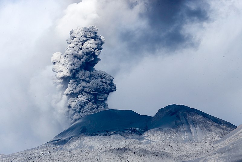
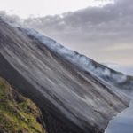
Philippines , Taal :
TAAL VOLCANO BULLETIN 29 March 2022 8:00 AM
Three (3) phreatomagmatic bursts from the Main Crater at 09:30AM, 09:33AM and 09:46AM yesterday were recorded by the Taal Volcano Network or TVN based on seismic records and visual cameras. These events produced 400 meter- to 800-meter-tall plumes that drifted southwest.
In the past 24-hour period, TVN recorded eight (8) volcanic earthquakes, including one (1) volcanic tremor event having duration of five (5) minutes and seven (7) low-frequency volcanic earthquakes. Activity at the Main Crater was dominated by upwelling of hot volcanic fluids in its lake which generated plumes 2,400 meters tall that drifted southwest. Sulfur dioxide (SO2) emission averaged 4,273 tonnes/day on 28 March 2022. Temperature highs of 63.7°C were last measured from the Main Crater Lake on 25 February 2022. Based on ground deformation parameters from electronic tilt, continuous GPS and InSAR monitoring, Taal Volcano Island and the Taal region has begun deflating in October 2021.
The Alert Level 3 (Magmatic Unrest) prevails over Taal Volcano. This means that there is a magmatic intrusion at the Main Crater that may further drive succeeding eruptions. DOST-PHIVOLCS strongly recommends Taal Volcano Island and high-risk barangays of Bilibinwang and Banyaga, Agoncillo and Boso-boso, Gulod and eastern Bugaan East, Laurel, Batangas Province be evacuated due to the possible hazards of pyroclastic density currents and volcanic tsunami should stronger eruptions subsequently occur. The public is reminded that the entire Taal Volcano Island is a Permanent Danger Zone (PDZ), and entry into the island as well as high-risk barangays of Agoncillo and Laurel must be prohibited. All activities on Taal Lake should not be allowed at this time.
Source : Phivolcs.
Photo : Terry Villanueva.
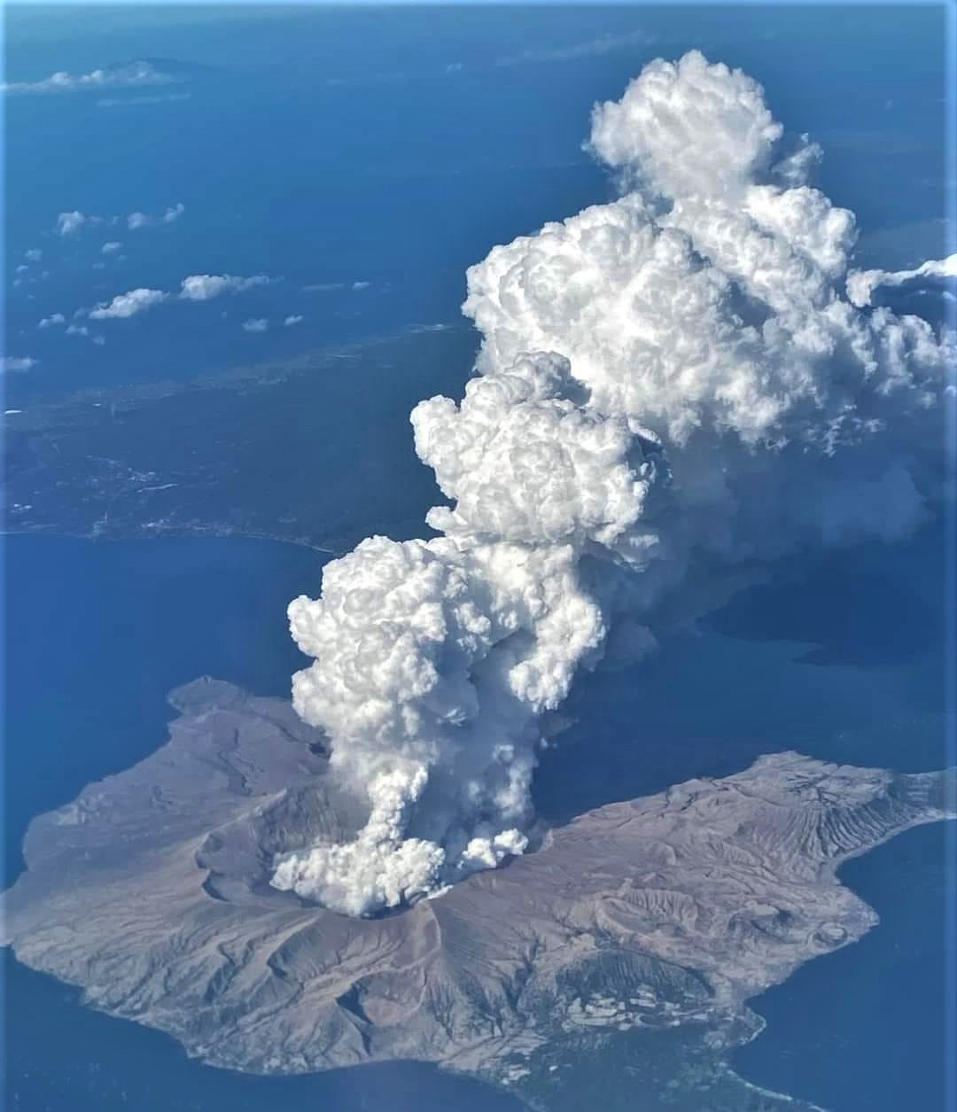
Indonesia , Anak Krakatau :
VOLCANO OBSERVATORY NOTICE FOR AVIATION – VONA
Issued : March 29 , 2022
Volcano : Anak Krakatau (262000)
Current Aviation Colour Code : ORANGE
Previous Aviation Colour Code : orange
Source : Anak Krakatau Volcano Observatory
Notice Number : 2022KRA24
Volcano Location : S 06 deg 06 min 07 sec E 105 deg 25 min 23 sec
Area : Lampung, Indonesia
Summit Elevation : 502 FT (157 M)
Volcanic Activity Summary :
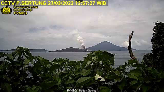
Eruption with ash clouds at 05:40 UTC (12:40 local time). The eruption lasted for 35 seconds
Volcanic Cloud Height :
Best estimate of ash-cloud top is around 2102 FT (657 M) above sea level, may be higher than what can be observed clearly. Source of height data: ground observer.
Other Volcanic Cloud Information :
Visuals directly from the cctv were observed eruptions with the color of the thick grey eruption smoke 500m from the top of the volcano, the wind direction slowly to the east.
Remarks :
Eruption recorded on seismogram with maximum amplitude 52 mm and maximum duration 35 second.
Source : Magma Indonésie.
Photo : Archive PVMBG.
Iceland , Reykjanes Peninsula:
Roughly 400 earthquakes were located by the IMO¿s SIL seismic network this past week, about third more than the previous week. For the last 5 weeks the weekly activity has been varying between 300-560 seismic event. The largest earthquake of the week was M3.0 located just 2 km sw of Djúpavatn on Reykjanes Peninsula on 17th of March.
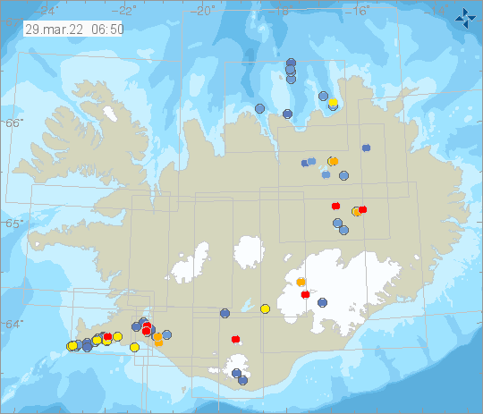
Around 150 earthquakes were measure in a swarm in Northwestern Mt. Þorbjörn from noon on the 18th of March till morning of 19th. Most of these events were of a small magnitude but the largest 5 events were of magnitude around 2. Additionally a rather shallow activity was recorded just East of Selfoss this week and a M1.7 event was felt there on the evening of 19th of March at 23:02. Other remarkable activity this week includes 15 events in eastern Skeiðarárjökull, a single event of magnitude 1.6 in Örnólfsdalur in Borgarfjörður and another single event, M1.4 in eastern Langjökull around 4 km west of Lake Hvítárvatn. Other activity was quite usual.
Source et photo : Vedur is


No comment yet, add your voice below!