August 11 , 2021 .
Italy , Stromboli :
Weekly Bulletin from August 02, 2021 to August 08, 2021, (issue date August 10, 2021).
SUMMARY STATEMENT OF ACTIVITY
In view of the monitoring data, it is highlighted:
1) VOLCANOLOGICAL OBSERVATIONS: Strombolian explosive activity of ordinary type with total hourly frequency of explosions and low level intensity
2) SEISMOLOGY: The seismological parameters monitored do not show significant variations.
3) DEFORMATIONS: No significant change to report.
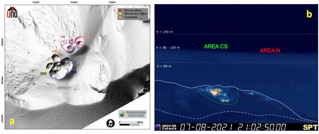
Digital model of the surface of the Stromboli crater area with indication of the different areas of the crater and the eruptive state of the vents (UNO Project / DPC Convention – Annex A). In (b) the crater terrace taken by the thermal camera placed on the Pizzo sopra la Fossa with the delimitation of the areas of the Center-South and North crater (CS and N respectively). The area above the crater terrace is divided into three height intervals relating to the intensity of the explosions.
4) GEOCHEMISTRY: SO2 flux at a medium-low level
The flow of CO2 from the ground to the Pizzo Sopra la Fossa remains at an average value.
The average weekly C / S value is 9.6 and is at average values. Last measurement recorded on 07/28/2021.
The isotopic ratio of Helium dissolved in the thermal aquifer compared to the last sampling of 07/27/2021 is at medium – high values.
5) SATELLITE OBSERVATIONS: The thermal activity in the summit area is low to moderate.
VOLCANOLOGICAL OBSERVATIONS
In the observation period, the eruptive activity of Stromboli was characterized by the analysis of the images recorded by the surveillance cameras INGV-OE placed at an altitude of 190 and 400 m, Punta dei Corvi, Pizzo and by an inspection in the summit area carried out on August 3 by INGV-OE staff.
The eruptive activity was produced by both the North and Center-South zones (respectively, the N zone and the CS zone) located in the depression which occupies the crater terrace.
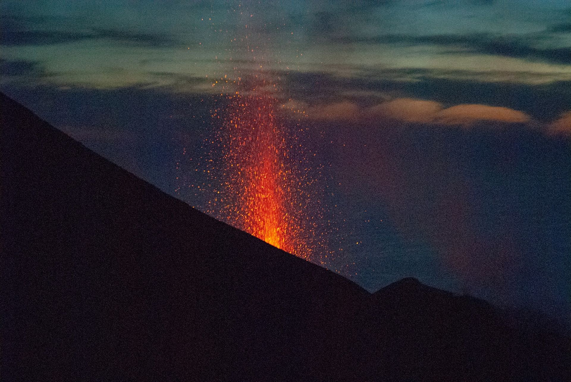
In the North zone, the eruptive activity was produced by vents located in sectors N1 and N2 with explosive activity and / or degassing at variable rate with production of mainly coarse material. The activity was particularly localized to the N2 compared to the N1 with the hornitos placed in this last sector which during the observation of August 3 seemed inactive and dominated by degassing and blasts. The average frequency of explosions was about 2.5 events / hour with low intensity (explosions from a height of 80 meters above the muzzle).
In the CS zone, the activity was mainly produced by the CS1 sector with explosions mainly with a fine component (ash) and secondarily coarse, coupled with a degassing and variable blast activity in the CS2 and CS3 zones. The average frequency of explosions was about 1.5 events / hour with low intensity. Overall, over the period considered, the total frequency of explosive events / hour, including both the N and CS zones, placed the activity at a low level (3.5 events / hour).
Source : INGV.
Photos : INGV.
Italy / Sicily , Etna :
Weekly Bulletin from August 02, 2021 to August 08, 2021, (issue date August 10, 2021).
SUMMARY STATEMENT OF ACTIVITY
In view of the monitoring data, it is highlighted:
1) VOLCANOLOGICAL OBSERVATIONS: Strombolian activity at the Southeast Crater, ash emissions at the Northeast Crater and degassing of varying intensity towards the other summit craters.
2) SEISMOLOGY: Seismic activity of weak fracturing. Amplitude of the volcanic tremor on the medium-low level. Large and sudden fluctuations up to high values can be correlated with the explosive activity of the Southeast Crater.
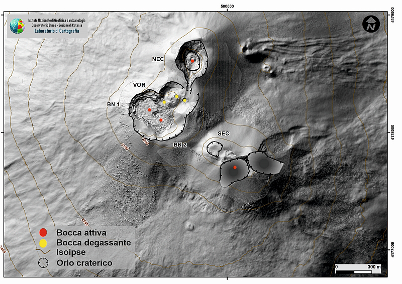
Map of the summit area of Etna on a shaded terrain model. BN: Bocca Nuova, VOR: Voragine; NEC: northeast crater; SEC: south-eastern crater. The topographic reference on which the morphological updates are superimposed is the DEM 2014 developed by the Aerogeophysical Laboratory-Section Rome 2.
3) INFRASON: Moderately low infrasound activity with events mainly localized in the area of the Bocca Nuova crater. With the exception of the phase of increase in the rate of occurrence and amplitudes of events located at the Southeast Crater, correlated with Strombolian activity at the Southeast Crater.
4) DEFORMATIONS: No significant variation to report, apart from the modest variation (of the order of a few microradians) observed during the lava fountain of August 9, 2021.
5) GEOCHEMISTRY: SO2 flux at medium level
The flow of CO2 emitted by the soil is at medium – low values.
The partial pressure of CO2 dissolved in water shows no significant change.
Helium isotope ratio is maintained at medium to high values
There are no updates for the C / S report.
6) SATELLITE OBSERVATIONS: The thermal activity in the summit area was at a high level during the last two lava fountains of the Southeast Crater on July 31 and August 9, 2021.
VOLCANOLOGICAL OBSERVATIONS
During the week, the monitoring of the volcanic activity of Etna was carried out thanks to the analysis of the images of the network of surveillance cameras of the INGV section of Catania, of the Etneo Observatory (INGV-OE) and through a field inspection of part of the INGV staff on August 2, 2021. During the observation period, the activity mainly concerned the Southeast Crater (CSE) and marginally the Northeast Crater .
In detail, during the period studied, the Southeast Crater essentially showed an intense degassing activity of the fumarolic field, accompanied by repeated episodes of Strombolian activity.
On August 7, from approximately 18:57 UTC (20:57 local), a resumption of Strombolian activity was observed at the level of the Southeast Crater, which produced isolated sporadic explosions with projection of incandescent material beyond the edge of the crater. During the night, this activity did not evolve and practically ceased.
The next day, August 8, an isolated explosion at 18:56 UTC announced – from around 22:30 UTC – a new resumption of Strombolian activity at the Southeast Crater, characterized by a more marked continuity and, again, by the frequent projection of incandescent material beyond the rim of the crater. The volcanic ash produced dispersed in the south-eastern sector of the volcano.
The numerous eruptive episodes of recent months from the Southeast Crater, characterized among other things by the continuous production of abundant pyroclastic material, have gradually and radically modified the morphology of the cone.
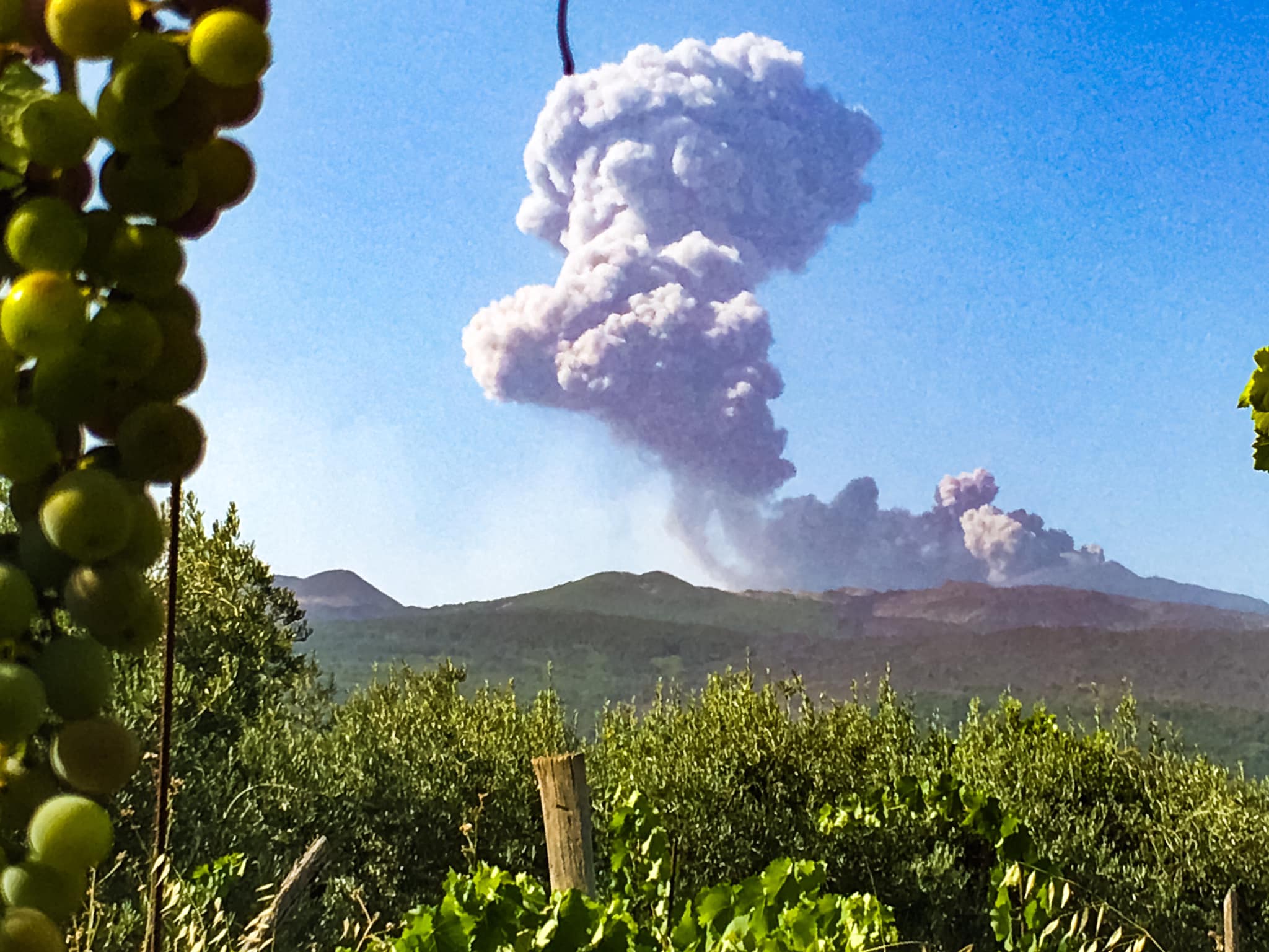
During the period studied, the northeast crater produced isolated, but sometimes intense, ash emission episodes. In particular, on August 4, starting at 11:50 UTC (13:50 local time), a discontinuous series of ash emissions from the northeast crater was observed, which lasted for about two hours. The volcanic cloud produced reached a height of about 6000 m above sea level, dispersing towards the northeast quadrant of the volcanic building. Similar broadcasts, but of lesser intensity, also took place on August 5.
The macroscopic characteristics (reddish color and predominantly fine grain size) of the material emitted and the absence of thermal anomalies visible from the cameras of the surveillance network, suggest that this phenomenology can be attributed to landslides and material at the inside the crater.
The Bocca Nuova crater was characterized by a pulsed and discontinuous degassing regime of the two currently active vents.
Finally, the activity at the Voragine crater was characterized only by fumarolic degassing.
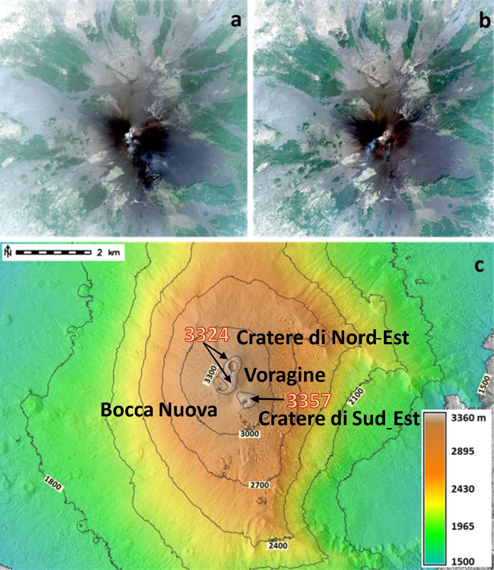
From the preliminary digital terrain model, it appears that the highest point of the volcano is located on the northern edge of the Southeast Crater at an altitude of 3357 ± 3 m.
The uncertainty was calculated based on the comparison with GPS measurements taken in the summit area at altitudes up to 3000 m above sea level. In order to verify the data resulting from the analysis of satellite images, in the coming months, measurement campaigns will be carried out on the ground from the summit.
COMMUNICATION ON THE ACTIVITY OF ETNA August 10, 2021, 09:56 (07:56 UTC).
The National Institute of Geophysics and Volcanology, Osservatorio Etneo, announces that at 07:20 UTC an explosive event took place at the Northeast Crater, generating an ash cloud that reached a height of about 6000 m and which s’ is then propagated towards the South-East. This explosion was followed by other low ash and vapor emissions; currently the phenomenon is decreasing.
From 07:19 UTC, a seismic sequence lasting approximately 1 minute was recorded, consisting of approximately 5 low frequency events of moderate energy, attributable to the explosive activity of the Northeast Crater. caused a sudden increase in the amplitude of the tremor to medium-low values and a subsequent return to low values.
Regarding infrasonic activity, no significant variation is recorded, except for a low energy infrasonic signal associated with the reported explosive activity.
Source : INGV.
Photos : EtNative – to explore Mount Etna , INGV.
Alaska , Semisopochnoi :
51°55’44 » N 179°35’52 » E,
Summit Elevation 2625 ft (800 m)
Current Volcano Alert Level: WATCH
Current Aviation Color Code: ORANGE
Ten separate explosions were detected from North Cerberus crater at Semisopochnoi over the past day, and a small low level plume at times was noted in satellite images drifting east. Small ash and steam emissions were detected in clear web camera images.

Small eruptions producing minor ash deposits within the vicinity of the active north crater of Mount Cerberus and ash clouds under 10,000 feet above sea level have characterized the recent activity and show no signs of abating. Small explosions may continue and could be difficult to detect especially during poor weather conditions.
Semisopochnoi is monitored by local seismic and infrasound sensors, satellite data, web cameras, and remote infrasound and lightning networks.
Source et photo : AVO.
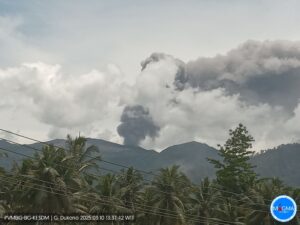
Kamchatka , Sheveluch :
VOLCANO OBSERVATORY NOTICE FOR AVIATION (VONA)
Issued: August 11 , 2021.
Volcano: Sheveluch (CAVW #300270)
Current aviation colour code: ORANGE
Previous aviation colour code: orange
Source: KVERT
Notice Number: 2021-85
Volcano Location: N 56 deg 38 min E 161 deg 18 min
Area: Kamchatka, Russia
Summit Elevation: 3283 m (10768.24 ft), the dome elevation ~2500 m (8200 ft)
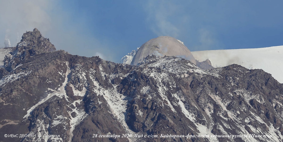
The new lava block extruded out in the eastern part of the lava dome of Sheveluch volcano.
A unique phenomenon was discovered on September 28, 2020 on the Sheveluch volcano. A block of lava of the most acsid composition in the entire history of development (since 1980) of the volcano’s lava dome is being extruded out. The likely composition of the lava is dacitic. The dome is named Dolphin. Date: 28/9/2020
Volcanic Activity Summary:
Activity of the volcano continues. According to video data, strong gas-steam emission containing some amount of ash continues at the volcano. The collapses of the Dolphin lava blocks, and small explosions are observing. Satellite data showed a gas-steam plume containing some amount of ash is extending for 51 km to the west-southwest of the volcano.
The extrusive eruption of the volcano continues. Ash explosions up to 10-15 km (32,800-49,200 ft) a.s.l. could occur at any time. Ongoing activity could affect international and low-flying aircraft.
Volcanic cloud height:
4500-5000 m (14760-16400 ft) AMSL Time and method of ash plume/cloud height determination: 20210811/0120Z – Video data
Other volcanic cloud information:
Distance of ash plume/cloud of the volcano: 51 km (32 mi)
Direction of drift of ash plume/cloud of the volcano: WSW / azimuth 243 deg
Time and method of ash plume/cloud determination: 20210811/0050Z – Himawari-8
Source : Kvert
Photo : Yu. Demyanchuk, IVS FEB RAS ,
Philippines , Taal :
TAAL VOLCANO BULLETIN 11 August 2021 8:00 AM
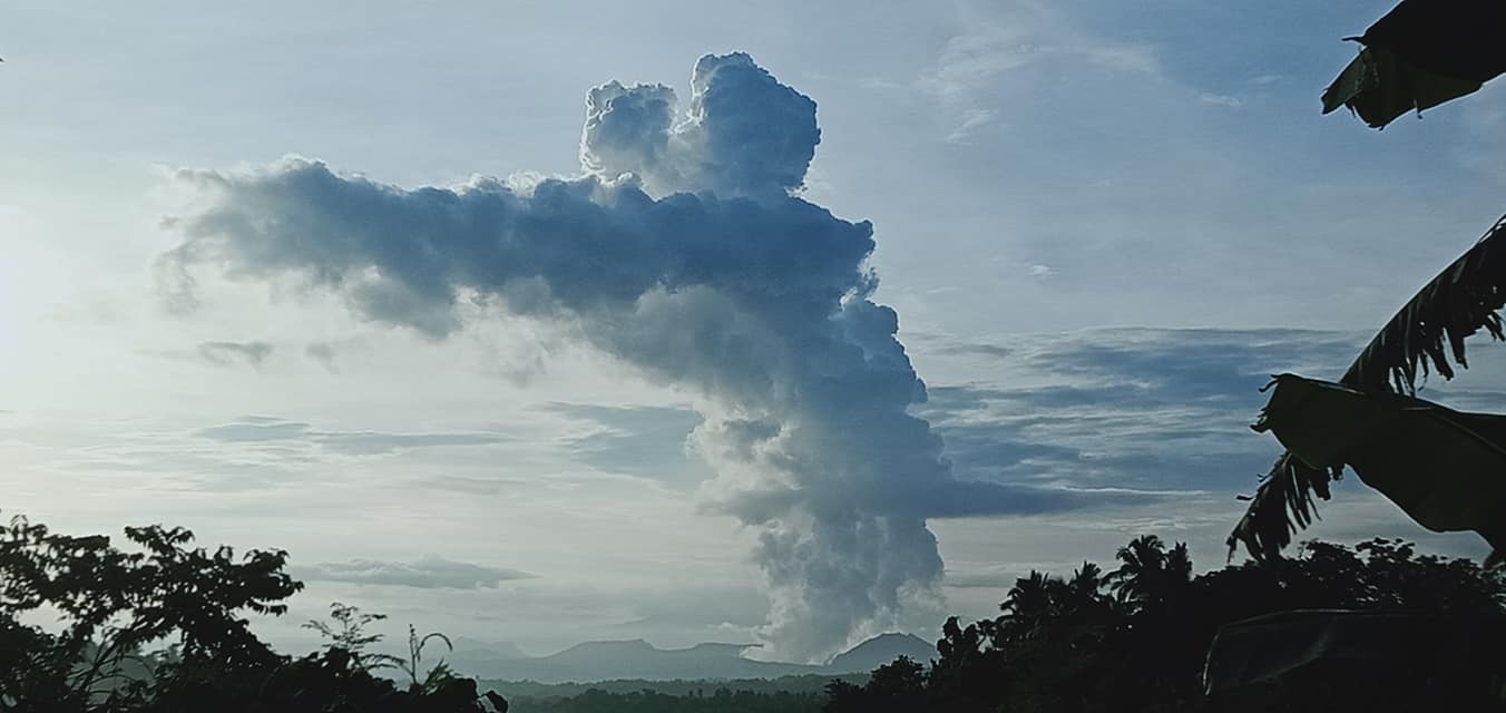
In the past 24-hour period, the Taal Volcano Network recorded one hundred seven (107) volcanic earthquakes, including one hundred (100) volcanic tremor events having durations of two (2) to thirty (30) minutes, six (6) low-frequency volcanic earthquakes, one (1) hybrid event, and low-level background tremor that has persisted since 07 July 2021. Activity at the Main Crater was dominated by upwelling of hot volcanic fluids in its lake which generated plumes 3,000 meters tall that drifted to the general north. Sulfur dioxide (SO2) emission averaged 3,849 tonnes/day on 09 August 2021. Based on ground deformation parameters from electronic tilt, continuous GPS and InSAR monitoring, Taal Volcano Island has begun deflating in April 2021 while the Taal region continues to undergo very slow extension since 2020.
Alert Level 2 (Decreased Unrest) now prevails over Taal Volcano. DOST-PHIVOLCS reminds the public that at Alert Level 2, sudden steam- or gas-driven explosions, volcanic earthquakes, minor ashfall, and lethal accumulations or expulsions of volcanic gas can occur and threaten areas within and around TVI. DOST-PHIVOLCS strongly recommends that entry must be strictly prohibited into Taal Volcano Island, Taal’s Permanent Danger Zone or PDZ, especially the vicinities of the Main Crater and the Daang Kastila fissure, and occupancy and boating on Taal Lake. Local government officials are advised to continuously assess and strengthen the preparedness of previously evacuated barangays around Taal Lake in case of renewed unrest. Civil aviation authorities must advise pilots to avoid flying close to the volcano as airborne ash and ballistic fragments from sudden explosions and wind-remobilized ash may pose hazards to aircraft.
DOST-PHIVOLCS is closely monitoring Taal Volcano’s activity and any new significant development will be immediately communicated to all stakeholders.
Source : Phivolcs
Photo : JhuLia Mendoza.
Colombia , Nevado del Ruiz :
Weekly activity bulletin of the Nevado del Ruiz volcano
The activity level continues at: Yellow activity level or (III): Changes in the behavior of volcanic activity.
Regarding the monitoring of the activity of the Nevado del Ruiz volcano, the COLOMBIAN GEOLOGICAL SERVICE reports that:
Over the past week, there has been an increase in the number of tremor pulses, long-lasting earthquakes, tremor pulse energy, and continuous volcanic tremor. Very long period earthquakes were also recorded, which showed similar levels in the number of events and in the seismic energy released compared to the previous week.
The earthquakes were located mainly in the Arenas crater. Some of these signals were associated with ash emissions, confirmed by cameras installed in the area of the volcano and by the report of officials of the Los Nevados National Natural Park and the Colombian Geological Service.
The seismicity generated by rock fracturing increased in number of earthquakes and decreased in seismic energy released compared to the previous week. The depths of the earthquakes ranged from 0.5 to 7.7 km. The maximum magnitude recorded during the week was 0.6 ML (local magnitude) corresponding to the earthquake recorded on August 8 at 13:33 (local time), located 5.3 km west of the Arenas crater, at a depth of 5.1 km.
Source : SGC.
Photo : Diana M Bustamante.
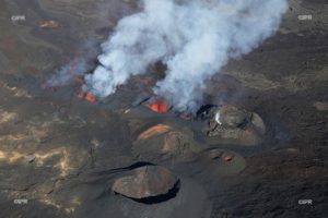
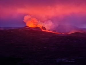
Iceland , Geldingadalur / Fagradalsfjall :
Update on the eruption in Fagradalsfjall mountain on 10-August-2021
The eruption continues as before with few hours of eruption and few hours of no activity. Each event is an active eruption as it would happen with any other volcano. The time between eruptions now is just shorter than in any volcano in Iceland.
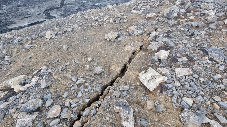
Cracks have appeared in the viewing area hill closest to the erupting crater. Why this is happening is unclear. There are two explanations for this. The first one is that this are tension cracks because of the eruption and lava flows nearby to this hill . The second explanation is that this is deformation cracks because magma is about to start erupting in this part of the hill. Formation of new cracks was observed early on in the eruption in Fagradalsfjall mountain few days before an eruption started in that area.
There is now slightly less lava flowing from the crater. Current flow is up to 9m3/sec according to latest reports about the lava flow. This studies are done by Earth Science of University of Iceland and Icelandic Metrology Office.
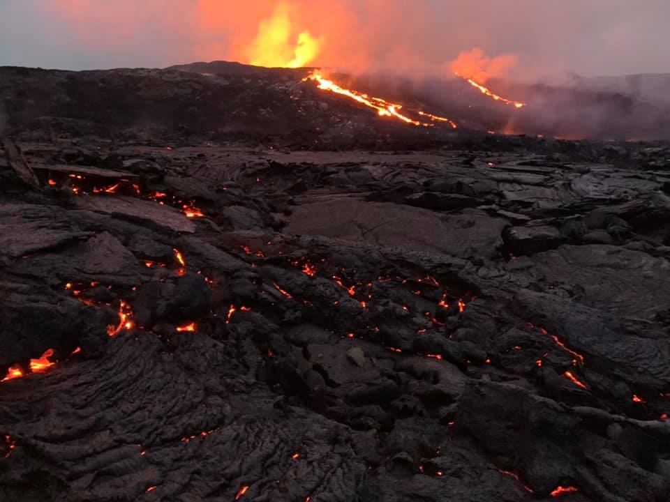
This eruption remains small. Currently it is even smaller than Hekla volcano 2000 eruption that was the smallest eruption in Hekla in recorded history . While the eruption remains this small the lava is not going to flow far or is going to do so slowly. Most of the lava is just going to build up next to the crater and next nearby area.
Source : icelandgeology.net
Read the article : https://icelandgeology.net/?fbclid=IwAR2lXUya158aMGGqJjNsIYWgJjHDuOUQlom1co7V75FwsWU4_-Pd_hdGexk
Photos : Reynir Freyr Petursson , Petur Thor via Alicja Szojer .