November 21 , 2020.
Alaska , Semisopochnoi :
AVO/USGS Volcanic Activity Notice
Current Volcano Alert Level: UNASSIGNED
Previous Volcano Alert Level: ADVISORY
Current Aviation Color Code: UNASSIGNED
Previous Aviation Color Code: YELLOW
Issued: Friday, November 20, 2020, 10:00 AM AKST
Source: Alaska Volcano Observatory
Notice Number: 2020/A1265
Location: N 51 deg 55 min E 179 deg 35 min
Elevation: 2625 ft (800 m)
Area: Aleutians
Volcanic Activity Summary:
No eruptive activity has been detected at Semisopochnoi since mid-June. Seismicity has persisted above background levels since that time, but had decreased to very low levels before a satellite link for transmitting seismic data failed on November 11, 2020. Since that time, no changes have been observed in satellite data, and no explosions have been detected from the Adak Island infrasound array. AVO is lowering the Aviation Color Code to UNASSIGNED and Alert Level to UNASSIGNED for Semisopochnoi due to the lack of evidence for ongoing unrest. Low-level seismic unrest may be continuing undetected. The satellite link is not likely to be reestablished without a site visit.
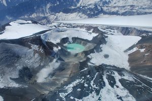
NE quadrant of caldera from just east of Mt Cerberus. Perret Ridge and Fenner Lk at top. Photos of Semisopochnoi Island taken in May 2017 during AVO station maintenance activities and supported by U.S. Coast Guard.
Despite the lack of eruptive activity since mid-June, Semisopochnoi has been in a state of unrest since September 2018, producing sporadic low-level explosions and elevated seismicity. Future small explosions may occur without warning and typically generate small clouds of volcanic ash that are a hazard in the immediate vicinity of the erupting vent at North Cerberus. More significant ash emissions may be possible, but have not been observed during the 2018–2020 eruptive period.
Recent Observations:
[Volcanic cloud height] n/a
[Other volcanic cloud information] n/a
Remarks:
The seismic monitoring network for Semisopochnoi has been offline since November 11, but if atmospheric conditions permit an infrasound array on Adak Island may detect explosion signals from Semisopochnoi with a 13 minute delay. Semisopochnoi is also monitored remotely with satellite observations and lightning sensors.
Source : AVO.
Source : Kaufman, Max.
Indonesia : Merapi:
Mount Merapi Activity Report November 13-19, 2020
OBSERVATION RESULTS
Visual
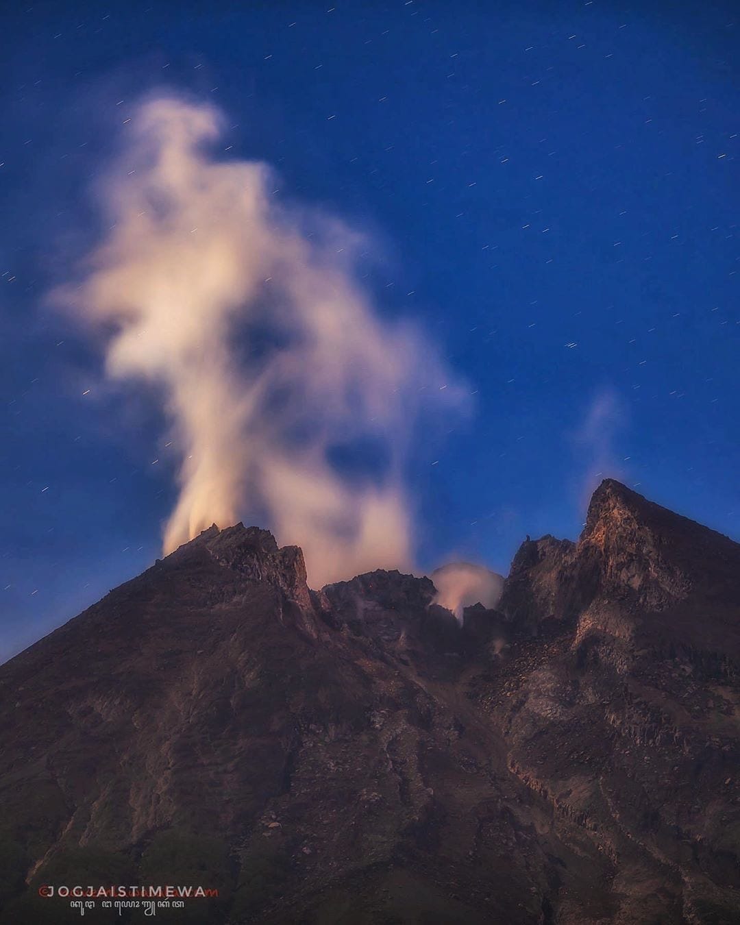
The weather around Mount Merapi is generally sunny in the morning, while the afternoon until evening is foggy. The smoke emitted is white, fine to thick with low pressure. A maximum smoke height of 200 m was observed from the Selo observation post on November 16, 2020 at 07:45 WIB. Avalanches were observed from the Babadan observation post with a maximum sliding distance of 2 km in the western sector upstream of Kali Lamat on November 14 at 06.15.
The analysis of the morphology of the crater area based on photos of the Southeast sector from November 19 to November 11, 2020 shows a change in the morphology of the dome, namely the collapse of part of the lava dome of 2018. Meanwhile, based on the drone photo analysis on November 16, 2020, changes in the morphology of the crater wall were observed due to the collapse of ancient lavas, especially Lava1997 ( South), Lava1998, Lava1888 (West) and Lava1954 (North). New lava domes were not observed. The calculation of the volume of the lava dome based on the drone photo is 200,000 m3.
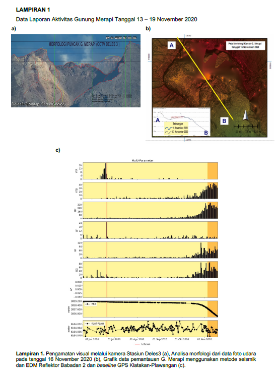
This week, the seismicity of Mount Merapi recorded
262 shallow volcanic earthquakes (VTB),
1939 multiphase earthquakes (MP),
7 low frequency earthquakes (LF),
441 avalanche earthquakes (RF),
352 emission earthquakes (DG)
8 tectonic earthquakes (TT).
The seismic intensity this week is higher than last week.
Deformation
Klatakan – Plawangan base GPS ranges from 6,164.05m to 6,164.06m The deformation of Mount Merapi which was monitored using EDM this week showed a shortening rate of 9cm / day .
Rain and lahars
This week there was rain at Mount Merapi Observation Post with the highest rainfall intensity of 64mm / hour for 60 minutes at Kaliurang Post on November 13, 2020. There was no report lahars or additional flow in the rivers flowing down from Mount Merapi.
Conclusion
Based on the results of visual and instrumental observations, it is concluded that:
1. There is an increase in volcanic activity at Mount Merapi, so the activity status is defined as the activity level « SIAGA ».
Source : BPPTKG
Photos : BPPTKG , Jogjaistimewa.
Chile , Nevados de Chillan :
During the period, 61 seismic events classified as volcano-tectonic (VT) were recorded, associated with fragile rupture processes in the volcanic system; the most energetic event had a local magnitude (ML) value of 2.7 and was located 2.5 km south-east (SE) of the crater with a depth of 2.7 km.
In addition, 1248 seismic events of the long period (LP) type were classified, associated with the dynamics of the fluids present in a volcanic system, making it possible to identify 575 events such as explosions at the level of the crater; the most energetic event had a reduced displacement value (RD) equal to 437 cm2. Likewise, 560 were classified as seismic events of the tremor type, associated with the sustained dynamics of the fluids present in a volcanic system; the most energetic event had a DR value equal to 233 cm2.
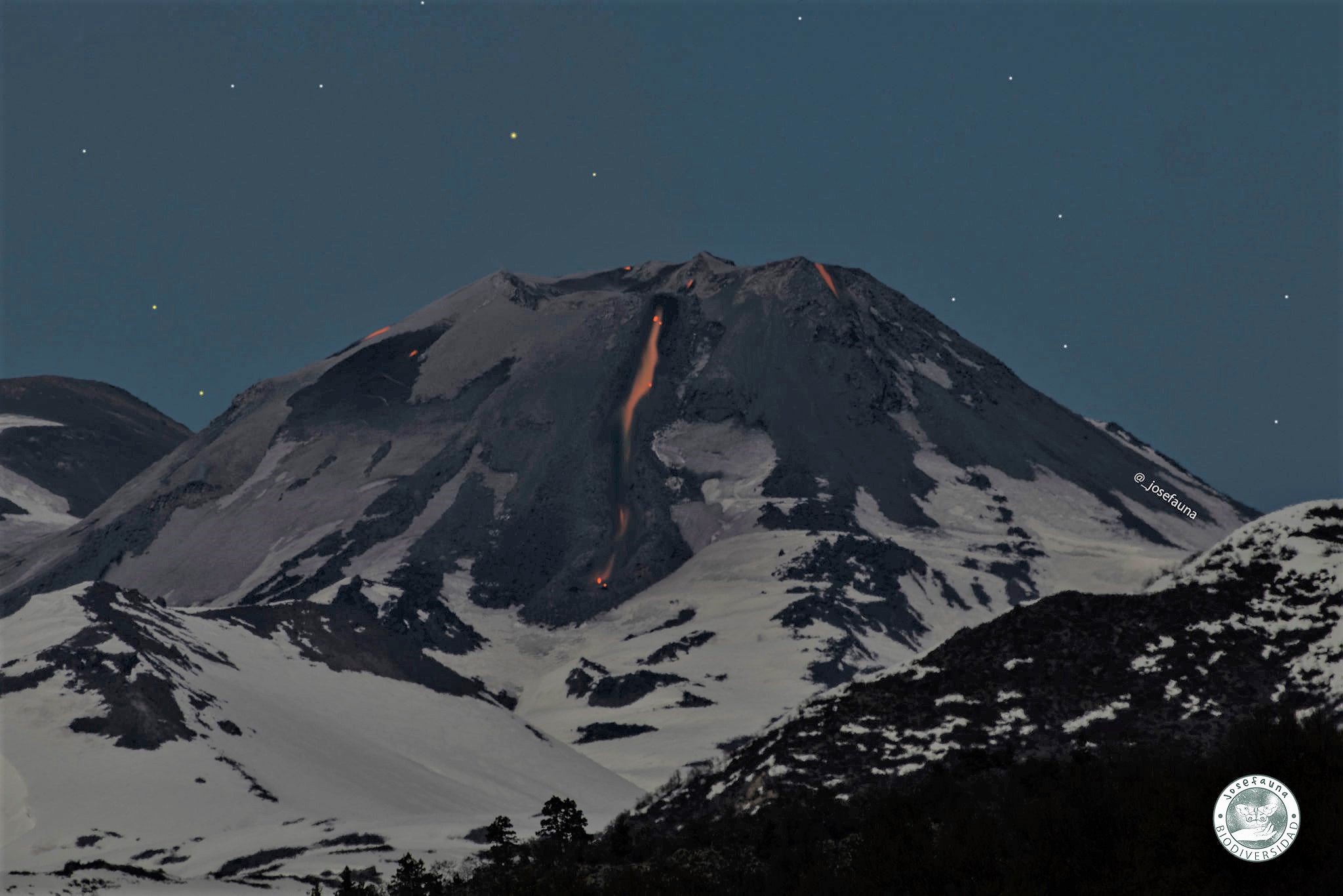
– The images provided by the fixed cameras installed around the complex made it possible to observe effusive and explosive activity during this fortnight. The latter activity was characterized by the presentation of explosions with column heights not exceeding 1140 m and mainly by an absence of particle content, it was only on certain occasions that ashes could be identified in their contents. When weather conditions allowed, a nocturnal incandescence focused on the eastern edge of the active crater (Nicanor crater) was observed.
– By processing the available thermal images, maximum temperatures of 334 ° C and 293 ° C were calculated during the occurrence of the explosions and for the L5 lava flow currently located on the North slope, respectively.
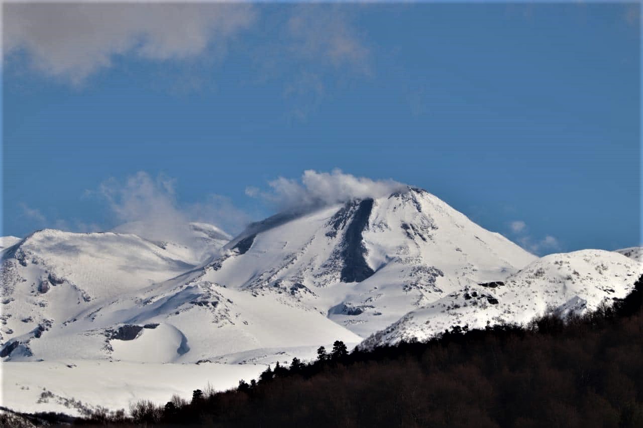
– On the other hand, the development of a minor crater continues on the inner eastern edge (E) of the Nicanor crater, which was identified thanks to satellite images during the previous fortnight; its permanence, as well as the observations of 2 emission sources during certain explosions, indicate that it remains active.
– Concerning the effusive activity and according to the photo-interpretation of the Pléiades and Sentinel L2 A satellite images, the L5 lava front, located on the northern slope of the volcano, maintained an advance, reaching an extension of 719 m from the edge of the crater, at a speed of 0.06 m / h, corresponding to the last measurement taken during this fortnight. As for the dome nestled in the Nicanor crater, its growth continues with minor morphological changes associated with explosions.
– According to the data provided by the monitoring stations which measure the surface deformation in the volcanic complex (5 GNSS and 2 inclinometers), the evolution of the inflationary trend is maintained during the period, measuring uplift rates between 0 , 3 and 0.5 cm / month at stations located around the active crater. Low rates of horizontal movement are maintained, as are variations in the distance between monitoring stations. Regarding the data provided by the electronic inclinometers, they remained without significant changes, with rates lower than those displayed in recent months, and with some variations due to non-volcanic factors (possibly melting or loss of snow).
10 thermal alerts were recorded in the area associated with the volcanic complex during the period, with a maximum volcanic radiative power (VRP) of 7 MW on November 12, a value deemed low according to data processed by the Medium infrared Observation of volcanic activity (MIROVA) and by near-real-time thermal monitoring of global hot spots (MODVOLC). Likewise, in the Sentinel 2-L2A satellite images, radiation anomalies were detected during days 1, 6, 9, 11 and 14 November.
The Nevados de Chillán Volcanic Complex remains stable in the context of a sustained eruptive cycle with the development of effusive activity, linked to the emission of a lava flow called L5 by the northern slope of the active crater and a low explosiveness reduced impact, linked to the growth of a lava dome nestled inside the crater. The deformation associated with the eruptive cycle continues to show variations, with a slight upward trend in the vertical components, suggesting the permanence of a weaker inflationary process. The seismic activity exhibits a stable behavior with respect to the power of the recorded signals. Most of the seismicity developed, associated with fluid dynamics and explosions, as well as thermal alerts and low-level degassing, is consistent with the development of surface magmatic bodies, which implies that the evolution of the current process does not show signs that immediately suggest further destabilization.
Therefore, the alert is maintained at the level:
YELLOW TECHNICAL ALERT: Changes in the behavior of volcanic activity.
Source : Sernageomin .
Photos : REAV Servicio Nacional de Geología y Minería. Josefauna.
Guatemala , Santiaguito :
VOLCANOLOGICAL BULLETIN SPECIAL # 118-2020
The Volcanological Observatory of the Volcanic Complex of Santa María-Santiaguito OVSAN reports events of explosions with heights of 3600 meters above sea level (11,811 feet) and the descent of weak pyroclastic flows from the dome of the crater of the Caliente dome to its base, in a westerly direction. This caused ash falls which fell on the volcanic perimeter and the towns in a southwest and east direction.
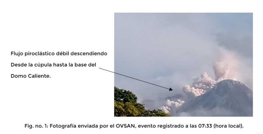
As mentioned in previous Special Bulletins, this type of event is due to the unstable accumulation of lava boulders and fine pyroclasts on the Caliente Dome, causing their detachment and channeling as avalanches and pyroclastic flows. This type of explosive event can be repeated over the following hours and days, as it is part of the Vulcanian-like activity that characterizes this complex of domes.
INSIVUMEH provides visual and instrumental surveillance thanks to its volcanological observers and stations, which record the seismic activity generated by the volcanic complex of Santa María-Santiaguito.
Source : Insivumeh .