Septembre 22 , 2020.
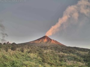
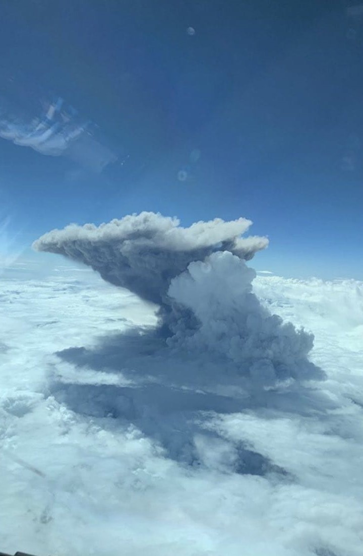
Alaska , Pavlof :
AVO/USGS Volcanic Activity Notice
Current Volcano Alert Level: ADVISORY
Previous Volcano Alert Level: NORMAL
Current Aviation Color Code: YELLOW
Previous Aviation Color Code: GREEN
Issued: Monday, September 21, 2020, 2:49 PM AKDT
Source: Alaska Volcano Observatory
Location: N 55 deg 25 min W 161 deg 53 min
Elevation: 8261 ft (2518 m)
Area: Alaska Peninsula
Volcanic Activity Summary:
Seismic activity has increased at Pavlof over the past 24 hours and is characterized by ongoing tremor. No eruptive activity or emissions from the summit have been observed in cloudy satellite and web camera views. However, the seismic activity represents an increase from background levels and we are thus increasing the the Aviation Color Code and Alert Level to YELLOW/ADVISORY. This does not mean that an eruption is likely or imminent. However, past eruptions of Pavlof occurred with little or no warning.
Recent Observations:
[Volcanic cloud height] None
[Other volcanic cloud information] None
[Lava flow/dome] None
[Lava flow] None
Hazard Analysis:
[Ash cloud] None observed
Remarks:
Pavlof Volcano is a snow- and ice-covered stratovolcano located on the southwestern end of the Alaska Peninsula about 953 km (592 mi) southwest of Anchorage. The volcano is about 7 km (4.4 mi) in diameter and has active vents on the north and east sides close to the summit. With over 40 historic eruptions, it is one of the most consistently active volcanoes in the Aleutian arc. Eruptive activity is generally characterized by sporadic Strombolian lava fountaining continuing for a several-month period. Ash plumes as high as 49,000 ft ASL have been generated by past eruptions of Pavlof, and during the March 2016 eruption, ash plumes as high as 40,000 feet above sea level were generated and the ash was tracked in satellite data as distant as eastern Canada. The nearest community, Cold Bay, is located 60 km (37 miles) to the southwest of Pavlof.
Source : AVO.
Source : Mulliken, Katherine , 21 Juillet 2018.
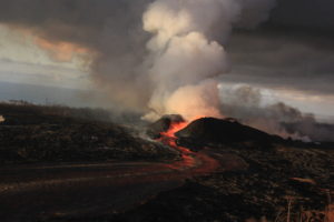
Ecuador , Sangay :
DAILY REPORT ON THE STATE OF SANGAY VOLCANO, Monday September 21, 2020.
Surface activity level: High, Surface trend: Increasing.
Internal activity level: High, Internal trend: Increasing.
Seismicity: From September 20, 2020, 11:00 a.m. to September 21, 2020, 11:00 a.m .:
Long period type events: 10
Explosions: 4
Emission tremor: 9
Rains / lahars:
Last night, rains were recorded in the area without generating any signals associated with secondary lahars.
** In case of heavy rains, lahars can be generated in the Volcán, Upano rivers and other tributaries **
Emission / ash column: Today in the morning on images shared by ECU911 and the network of volcanic observers, gas and ash emissions were observed which rose 1000m above the crater level looking west. The VAAC recorded 7 ash emission alerts, the direction of dispersion was towards the West. These emissions reached heights of 600 meters to 6,891 meters above the crater level.
Other monitoring parameters: FIRMS recorded 24 thermal alerts on the Sangay in the last 24 hours.
MIROVA has recorded 1 moderate thermal alert on the Sangay during the last 24 hours.
Observations: At the end of yesterday afternoon, the volcano was partially cleared, making it possible to observe the ash cloud produced by the emissions reported yesterday and the decrease in pyroclastic flows on the south-eastern flank of the volcano. Until the close of this bulletin, there is still a remobilization of ashes in the provinces of Bolívar, Chimborazo, Los Ríos, Guayas and Santa Elena due to the winds.
Alert level: yellow.
Source : IGEPN.
Photo : DANI100SWEET.
Peru : Sabancaya :
Analysis period: September 14 to 20, 2020, Arequipa, September 21, 2020.
Alert level: ORANGE
The Geophysical Institute of Peru (IGP) reports that the eruptive activity of the Sabancaya volcano remains at moderate levels; that is to say with the continuous recording of explosions with columns up to 2.5 km altitude above the summit of the volcano and consequent emissions of ash and gas. Therefore, for the following days, no significant change is expected regarding its eruptive activity.
The IGP recorded and analyzed the occurrence of 1899 volcanic earthquakes, associated with the circulation of magmatic fluids within the Sabancaya volcano. An average of 37 explosions of low to medium intensity was recorded daily.

During this period, the Volcano-Tectonic (VT) earthquakes were located mainly in the North-East and North-West areas of Sabancaya and presented magnitudes between M1.6 and M3.5. The representative earthquake (M3.5) was recorded on September 16 at 5:06 am, 14 km northwest of Sabancaya and 8 km deep.
The monitoring of the deformation of the volcanic structure, using GNSS equipment (processed with fast orbits), recorded a slight inflation of the south-eastern flank of the Sabancaya volcano and of the northern sector of Hualca Hualca. Visual surveillance made it possible to identify columns of gas and ash up to 2.5 km altitude above the summit of the volcano, which were scattered towards the South, South-East, East and North-East sectors of the volcano. Sabancaya. Satellite monitoring has identified the presence of 5 thermal anomalies with values between 9 MW and 44 MW, associated with the presence of a lava body (dome) on the surface of the volcano’s crater.
RECOMMENDATIONS
• Maintain the orange volcanic alert level.
• Do not approach within a radius of less than 12 km from the crater.
Source : IGP
Photo : Andina .
Guatemala , Santiaguito :
Type of activity: Pelean
Morphology: Complex of dacitic domes
Geographical location: 14 ° 44 ’33 ˝ Latitude N; 91 ° 34’13˝ west longitude.
Height: 2500 m.
Partly cloudy weather conditions
Wind: northeast
Precipitation: 44.7 mm.
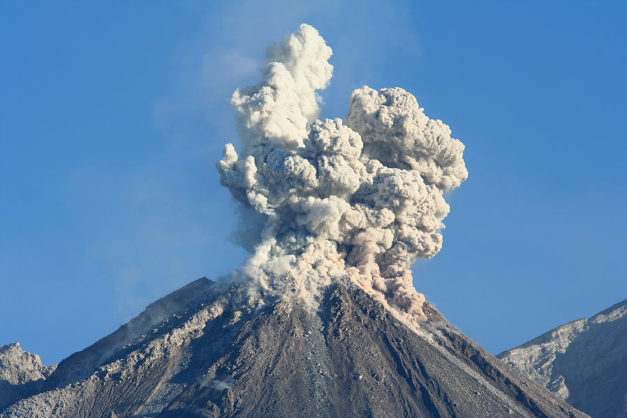
Activity:
Prolonged degassing of white color which disperses towards the West and the South-West. There are explosions that raise gray columns from a height of 3300 meters above sea level (10,826 feet) which disperse to the West and Southwest. Avalanches are generated towards the southwest, south and southeast flanks, with distances to the base of the dome. Fine particles of ash fall on the volcanic perimeter. A prolonged incandescence during the night and early in the morning is observed in the crater of the Caliente dome. The appearance of block flows from the dome of the Caliente dome, as well as pyroclastic flows over long distances, is not excluded. For short periods, it is possible to hear sounds similar to those of an airplane turbine, due to outgassing in the Caliente dome. The recommendations of the special BESAN bulletin n ° 75-2020 remain in force.
Source : Insivumeh.
Photo : Auteur inconnu.
La Réunion , Felt earthquake :
Bulletin for Monday, September 21, 2020 at 9:00 p.m. (local time) – felt earthquake
On Monday September 21, 2020, 9:00 p.m. (local time – 5:00 p.m. UT), an earthquake was felt by residents of the island, mainly in the North, but also in the West and East, and less clearly in the South.
This earthquake was recorded by the entire network of seismometers of the Volcanological Observatory of Piton de la Fournaise. The first analyzes of this earthquake made it possible to locate it, 27 km below sea level, 22 km north-west of Saint Denis. Its magnitude was measured at 4.4 on the Richter scale.
This type of event, felt by the population, is recorded several times a year. This event is currently isolated and is of tectonic origin.
Source : OVPF.