April 05 , 2019.
Indonesia , Agung :
VOLCANO OBSERVATORY NOTICE FOR AVIATION – VONA.
Issued: April 03 , 2019
Volcano: Agung (264020)
Current Aviation Colour Code: ORANGE
Previous Aviation Colour Code: orange
Source: Agung Volcano Observatory
Notice Number: 2019AGU14
Volcano Location: S 08 deg 20 min 31 sec E 115 deg 30 min 29 sec
Area: Bali, Indonesia
Summit Elevation: 10054 FT (3142 M)
Volcanic Activity Summary:
Eruption with volcanic ash cloud at 17h31 UTC (01h31 local). Eruption and ash emission is not continuing.
Volcanic Cloud Height:
Best estimate of ash-cloud top is around 16454 FT (5142 M) above sea level, may be higher than what can be observed clearly. Source of height data: ground observer.
Other Volcanic Cloud Information:
Ash-cloud moving to west
Remarks:
Seismic activity is characterized by volcanic earthquake
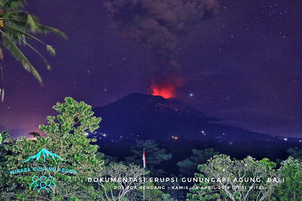
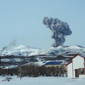
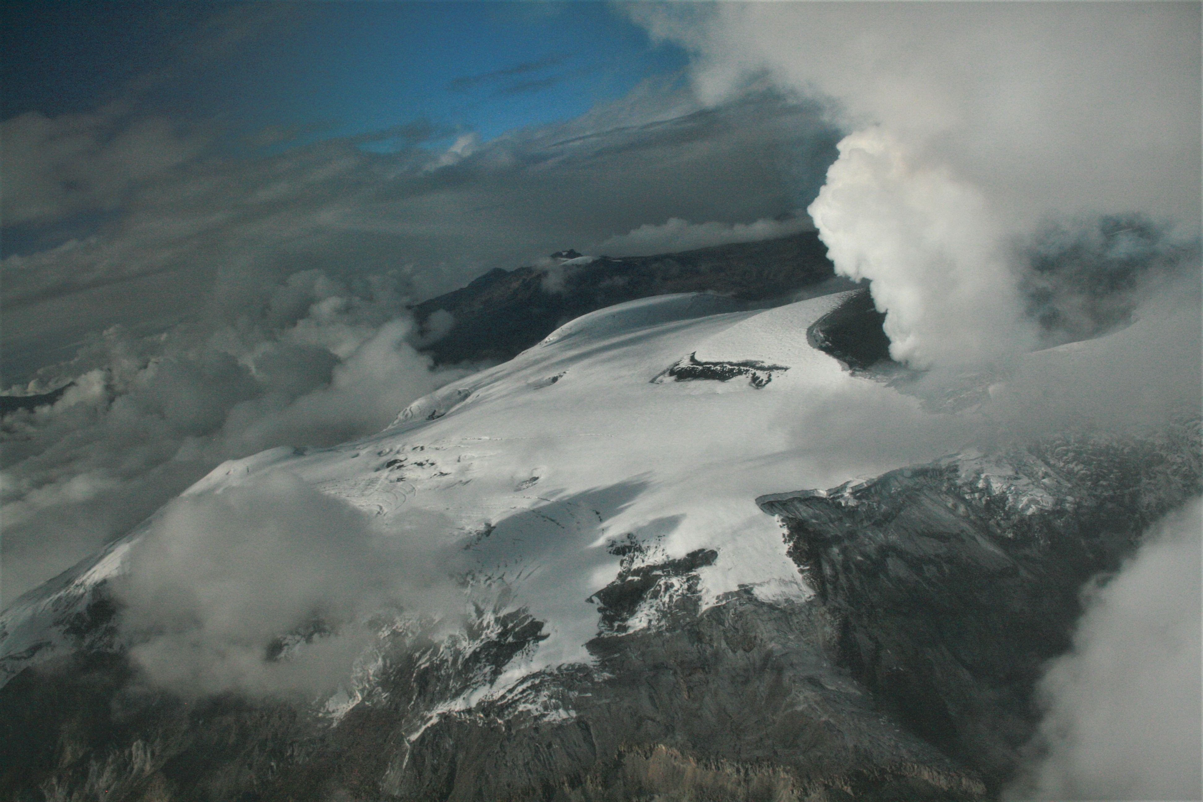
An eruption of Mount Agung in Bali occurred on April 4, 2019 at 01:31 WITA with a height of the ash column observed at ± 2,000 m above the summit (± 5,142 m above sea level) ). The column of ash was observed to be gray with a thick intensity, facing west. This eruption is recorded on a seismogram of maximum amplitude of 25 mm and a duration of ± 3 minutes 37 seconds.
A roaring roar was heard as far as the Rendang Observation Post.
Currently, G. Agung is at Level III (SIAGA) with recommendations:
(1) The communities around Mount Agung and mountaineers / visitors / tourists must not climb or carry out any activity in the estimated danger zone, ie in all areas within 4 km radius of Mount Crater. Agung. The estimated risk area is dynamic and continues to be evaluated. It can be modified at any time to follow the most recent observation data from G. Agung.
(2) Communities that reside and move around rivers flowing from Gunung Agung should be aware of the potential secondary threat of lahar flows that can occur especially during the rainy season and if the eruption material is always exposed in the peak area.
Source : Magma Indonésie , PVMBG.
Photo : wirasa gunung agung
Colombia , Nevado del Ruiz :
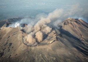
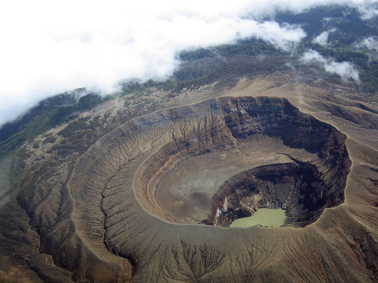
Weekly activity bulletin of the Nevado del Ruiz volcano
The level of activity continues at the level: Yellow activity level or (III): Modifications of the behavior of the volcanic activity.
With regard to monitoring the activity of the Nevado del Ruiz volcano, the COLOMBIAN GEOLOGICAL SERVICE informs that:
During the last week, the seismicity caused by rock fracturing resulted in a slight decrease in the number of earthquakes and released seismic energy compared to the previous week. The earthquakes were mainly located in the north-east and south areas of the volcano and in the Arenas crater, at depths between 1.1 and 6.8 km. The maximum magnitude recorded during the week was 0.6 ML (local magnitude) corresponding to the March 26 earthquake at 3:15 pm (local time) in the Arenas crater at a depth of 2.2 km.
Compared to the previous week, the seismicity related to fluid dynamics inside the ducts of the volcanic structure showed similar behavior both with respect to the number of earthquakes and the seismic energy released. This type of seismic activity was characterized by the presence of earthquakes of variable energy levels, generally low, long period type (LP), very long period (VLP) and pulses of volcanic tremor. The earthquakes occurred mainly in the crater Arenas and its surroundings. Some of these signals were associated with small ash emissions.
Volcanic deformation, measured from electronic inclinometers, has not recorded any significant changes over the past week.
The volcano continues to emit water vapor and gases into the atmosphere, among which is the sulfur dioxide (SO2), as evidenced by the values obtained by the SCANDOAS stations installed in the region of the volcano. satellite image analysis. During the week, the NASA FIRMS and MIROVA portals reported several low-energy thermal anomalies.
The column of gas and steam reached a maximum height of 1500 m, measured at the top of the volcano on March 31st. The direction of dispersion of the column was governed by the direction of the wind in the region, which prevailed towards the northwest of the volcano.
The Nevado del Ruiz volcano continues at the level of yellow activity.
Source : SGC
Photo : Fuerza Aérea Colombiana.
El Salvador , Santa Ana (Ilamatepec) :
Location: shared by the departments of Santa Ana and Sonsonate
Altitude: 2381 meters above sea level (msnm)
Type of volcano: Stratovolcano
Attraction type: Vulcanian – Strombolian
Last eruption: October 1, 2005.
The seismic vibration of the volcano fluctuated between 28 and 33 RSAM units on average per day, ie in the normal range. The San Blas seismic station recorded 35 earthquakes related to the movement of fluids in the volcanic system. With regard to earthquakes associated with the rupture of solid media, only one was recorded and located, to the west of the volcano crater, with a depth of 6 kilometers and a magnitude of 1.8. The inhabitants of the region did not speak of significance. Emissions of sulfur dioxide (SO2) have fluctuated between 72 and 438 tonnes per day, averaging 248 tonnes. Values taken into account in the baseline values (<300 tonnes / day) and typical of a volcanic system with constant gas emissions. Reports from MARN guards who visit the crater do not report a change in activity. The changes recorded through the instruments and the visits made indicate that the volcano presents a normal activity like any active volcano.
Source : Marn.
Photo : USAF.C-130.3
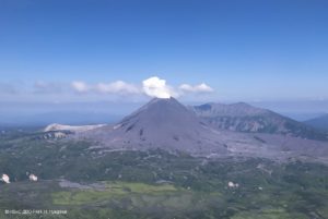
Philippines , Mayon :
MAYON VOLCANO BULLETIN 05 April 2019 08:00 A.M.
Mayon Volcano’s seismic monitoring network recorded four (4) rockfall events during the 24-hour observation period. Moderate emission of white steam-laden plumes that crept downslope before drifting west-southwest was observed. Faint crater glow from the summit could be observed at night. Sulfur dioxide (SO2) emission was measured at an average of 982 tonnes/day on 03 April 2019. Precise leveling data obtained on 20 – 26 March 2019 indicate a slight inflation of the edifice relative to 25 January-03 February 2019. This is consistent with measurements from continuous GPS and electronic tilt observations showing inflation of the edifice since June 2018.
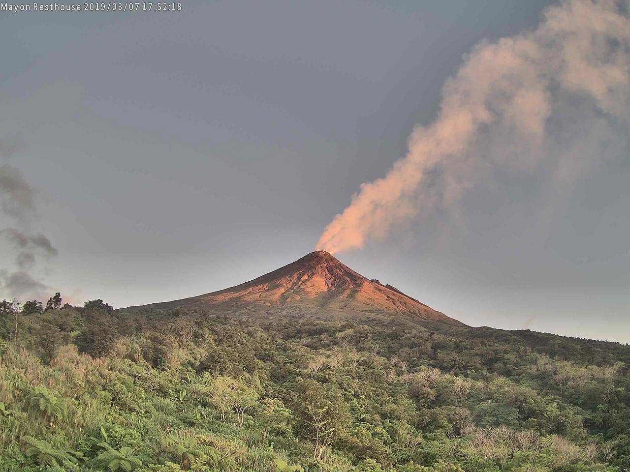
Alert Level 2 currently prevails over Mayon Volcano. This means that Mayon is at a moderate level of unrest. DOST-PHIVOLCS reminds the public that sudden explosions, lava collapses, pyroclastic density currents or PDCs and ashfall can still occur and threaten areas in the upper to middle slopes of Mayon. DOST-PHIVOLCS recommends that entry into the six kilometer-radius Permanent Danger Zone or PDZ and a precautionary seven kilometer-radius Extended Danger Zone or EDZ in the south-southwest to east-northeast sector, stretching from Anoling, Camalig to Sta. Misericordia, Sto. Domingo must be strictly prohibited. People residing close to these danger areas are also advised to observe precautions associated with rockfalls, PDCs and ashfall. Active stream/river channels and those identified as perennially lahar-prone areas on all sectors of the volcano should also be avoided especially during extreme weather conditions when there is heavy and prolonged rainfall. Civil aviation authorities must advise pilots to avoid flying close to the volcano’s summit as airborne ash and ballistic fragments from sudden explosions and PDCs may pose hazards to aircrafts.
Source : Phivolcs
Photo : volcanodiscovery.
Guatemala , Fuego :
VOLCANOLOGICAL SPECIAL BULLETIN BEFGO # 06-2019. Guatemala on April 4, 2019 at 19:00 (local time).
LAHARES MODERATE IN THE CANYON SECA , VOLCANO FUEGO (1402-1409)
Type of activity: Vulcanian
Morphology: Composite Stratovolcano
Geographical location: 14 ° 28’54˝Latitude N; 90 ° 52’54˝Longitude W.
Altitude: 3,763msnm.
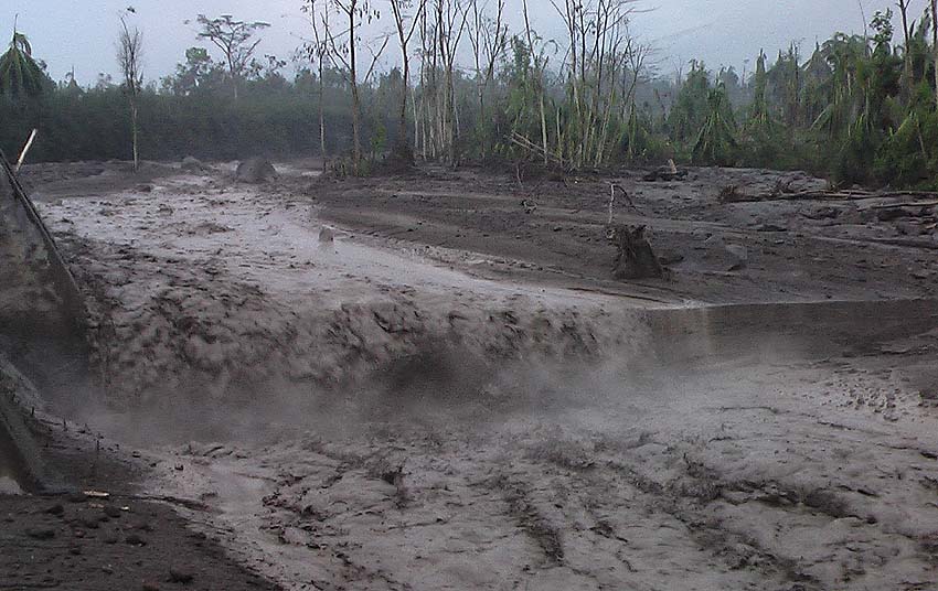
Precipitation during the afternoon in the region of Fuego volcano is currently generating the descent of a lahar with moderate characteristics in the Barrancas Seca, tributary of Rio Pantaleón.
These lahars have characteristics when they start from pasty material, with blocks ranging from a few centimeters to two meters in diameter, branches and tree trunks, some of them come down hot so it raises steam columns .
Because of the rains that can be generated in the afternoon and evening around the volcano, the possibility of lahars in one of the main ravines is not excluded.
Source : Insivumeh.
Indonesia , Anak Krakatau :
VOLCANO OBSERVATORY NOTICE FOR AVIATION – VONA.
Issued: April 04 , 2019
Volcano: Anak Krakatau (262000)
Current Aviation Colour Code: ORANGE
Previous Aviation Colour Code: orange
Source: Anak Krakatau Volcano Observatory
Notice Number: 2019KRA49
Volcano Location: S 06 deg 06 min 07 sec E 105 deg 25 min 23 sec
Area: Lampung, Indonesia
Summit Elevation: 502 FT (157 M)
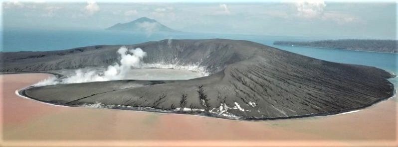
Volcanic Activity Summary:
Eruption with volcanic ash cloud at 13h03 UTC (20h03 local).
Volcanic Cloud Height:
Ash-cloud is not visible
Other Volcanic Cloud Information:
0
Remarks:
Eruption recorded on seismogram with maximum amplitude 55 mm and maximum duration 286 second.
Source : Magma Indonesia
Photo : earthuncut