
June 25 , 2019.
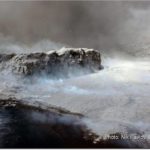
Peru , Sabancaya :
Period of analysis: from June 17 to 23, 2019. Arequipa, June 24, 2019
Alert level: ORANGE
The Geophysical Institute of Peru (IGP) reports that the eruptive activity of the Sabancaya volcano remains moderate. Therefore, for the following days, no significant change is expected.
The analysis of the recordings obtained from the seismic network of the Sabancaya volcano for the period from 17 to 23 June 2019 has made it possible to identify the occurrence of about 2382 volcanic earthquakes, the highest percentage of which is associated with the movements of magmatic fluids. During this week, an average of 16 low to moderate daily blasts were recorded.
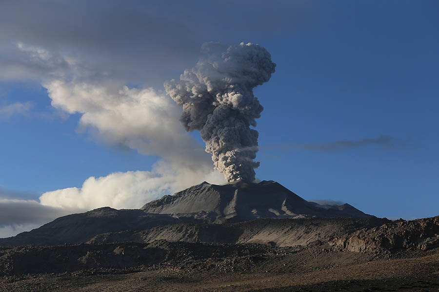
The monitoring of the deformation of the volcanic structure, using GNSS data (processed with fast orbits), presents no significant anomalies. Visual surveillance, using surveillance cameras, identified the appearance of columns of gas and ash reaching an altitude of 3.2 km above the top of the volcano, whose ashes were scattered throughout the volcano. the East, South-East and North-West sectors of Sabancaya. Satellite monitoring identified 9 volcanic anomalies on the volcano ranging from 1 to 77 MW, associated with the presence of a hot body near the surface and the occurrence of continuous explosions.
RECOMMENDATIONS:
Do not approach within 12 km of the crater.
In case of ash fall, cover the nose and mouth with damp cloths or masks.
Keep doors and windows closed.
Implement prevention and mitigation actions in response to increased volcanic activity.
Source : IGP
Photo : Unknown author
Peru , Ubinas :
Period of analysis: June 21 to 24, 2019. Arequipa, June 24, 2019
Alert level: Yellow
The Geophysical Institute of Peru (IGP) reports that the Ubinas volcano has launched a new eruptive process. At present, continuous emissions of ash and increased seismic activity related to the rise of magmatic fluids are being recorded; therefore, the authorities are urged to immediately raise the volcanic alert level from green to yellow.
The IGP analyzed seismic activity recorded between 21 and 24 June 2019. Seismicity related to the movements of volcanic fluids (water vapor, gas and magma) was recorded with a total of 80 signals; similarly, the events associated with rock breakage processes inside the volcano have increased considerably, at a rate of 154 earthquakes per day.

On 24 June, surveillance cameras recorded emissions from ashes, gases and water vapor scattered in the north and northeast directions of the crater. The monitoring of the deformation of the volcanic structure, using GNSS data (processed with fast orbits), presents no anomalies. Satellite monitoring, using information from SENTINEL systems, corroborates the direction of dispersion of ashes recorded by surveillance cameras. Data obtained from TROPOMI (SO2) and MIROVA (thermal anomalies) show no changes in the analysis period.
RECOMMENDATIONS:
The authorities are urged to immediately raise the alert level from green to yellow.
The use of lenses and masks is recommended to prevent harm to health.
Source : IGP
Photo : Auteur Inconnu
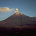
Russia / Kurile Islands , Raikoke :
Information message on the state of the Raikoke volcano.
June 24, 2019
According to the Sakhalin Volcanic Eruption Response Team (SVERT), based on satellite data from Himawari-8, June 21 at 18:05 UTC, a strong explosive eruption of the Raikoke volcano began in the central Kuriles. From 18:05 to 18:30 UTC, 6 volcanic explosions were recorded at a height of 10 to 13 km. At 0430 UTC on 22 June, the ash plume was 920 km long and extended mainly eastward.
The Raikoke, in the description of GS Gorshkov (catalog of active volcanoes of the Kurile Islands, 1957) is an island-volcano in the form of a strongly truncated cone with a height of 551 m and 2500 m above the bottom marine. At the top of the cone is a large closed crater with a diameter of about 700 m and a depth of 200 m, the last powerful explosive eruption having occurred in 1924.
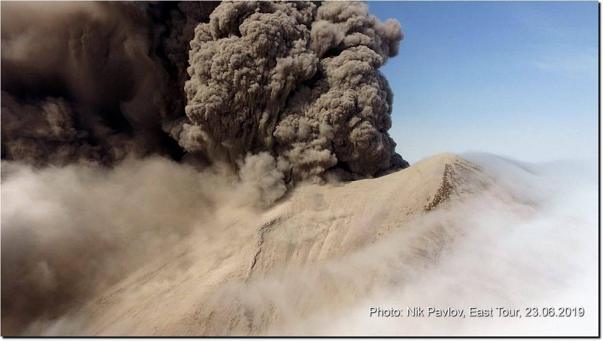
On June 23, the ship Athena approached the island, making a tourist trip to the Kuril Islands. Thanks to expedition member Nikolai Pavlov, the first photographs of the Raikoke volcano after the eruption began and its first description were obtained.
« On June 23 at 17:20 Kamchatka time, we approached the west side of the Raikoke and drifted in 1 km of rocks floating in the sea. On this side alone, the sun was passing and it was possible to reach the shore with the drone. The entire surface of the island was covered with a thick layer of ashes of a beige-whitish color up to several tens of centimeters. For some places, fresh scree was several meters thick. The highly mineralized water had a characteristic yellowish-greenish hue, and closer to the shore was brown in color. Lava flows have not been observed. When the waves rolled in some places, steam explosions occurred with the release of dark brown steam. The gaseous ash plume of the crater was heading west, the height of the plume near the island was about 1.5 km above the crater. A single cliff was previously separated from the island by a small strait 30 m wide, which is now completely buried so that the slope is leaning against the cliff.
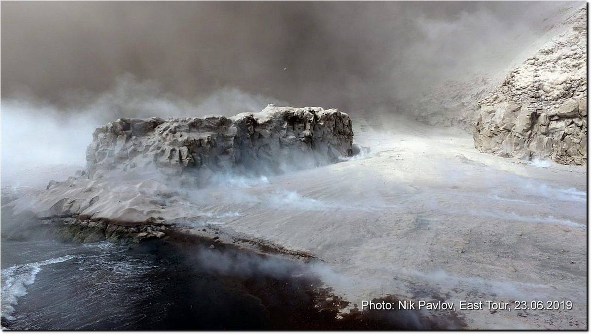
The photographs show that the coastline is considerably altered by pyroclastic flow deposits. There are many secondary fumarolic jets on the sediment surface.
On June 23rd from Severo-Kurilsk, from 7:30 to 20:20 UTC, there was a small ash drop caused by this eruption that reached Paramushir due to the southwesterly elevated winds.
Source : KSCNET.RU.
Photos : Niki Pavlov , 23/06/2019
Indonesia , Anak Krakatau :
VOLCANO OBSERVATORY NOTICE FOR AVIATION – VONA .
Issued: June 25 , 2019.
Volcano: Anak Krakatau (262000)
Current Aviation Colour Code: ORANGE
Previous Aviation Colour Code: orange
Source: Anak Krakatau Volcano Observatory
Notice Number: 2019KRA118
Volcano Location: S 06 deg 06 min 07 sec E 105 deg 25 min 23 sec
Area: Lampung, Indonesia
Summit Elevation: 502 FT (157 M)
Volcanic Activity Summary:
Eruption with ash clouds at 02:22 UTC (09:22 local time). The eruption lasted for 149 seconds.
Volcanic Cloud Height:
Ash-cloud is not visible
Other Volcanic Cloud Information:
. Anak Krakatau volcano is not clear.
Remarks:
Eruption recorded on seismogram with maximum amplitude 45 mm and duration 149 second.
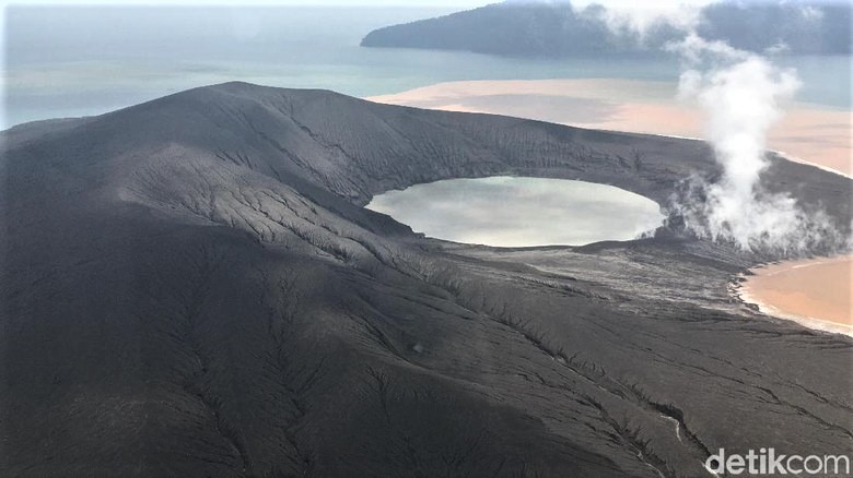
Level of activity at level II (Waspada), since 25 March 2019. The Anak Krakatau (157 m altitude) has increased its volcanic activity since 18 June 2018 which was followed by a series of eruptions from September 2018 to February 2019. In May 2019, eruptions still occur but of decreasing intensity.
Since yesterday and until this morning, the visual volcanoes were covered with fog. The smoke from the crater is not observed.
The seismograph of June 24, 2019 recorded:
1 eruption earthquake
1 earthquake emission
1 distant tectonic earthquake
Tremor continuous amplitude 1-35 mm, dominant 7 mm
Recommendation:
People / tourists are not allowed to approach the crater within 2 km of the crater.
Source : PVMBG , Magma Indonésie
Photo : Arief/detikcom ( 01 / 2019).


No comment yet, add your voice below!