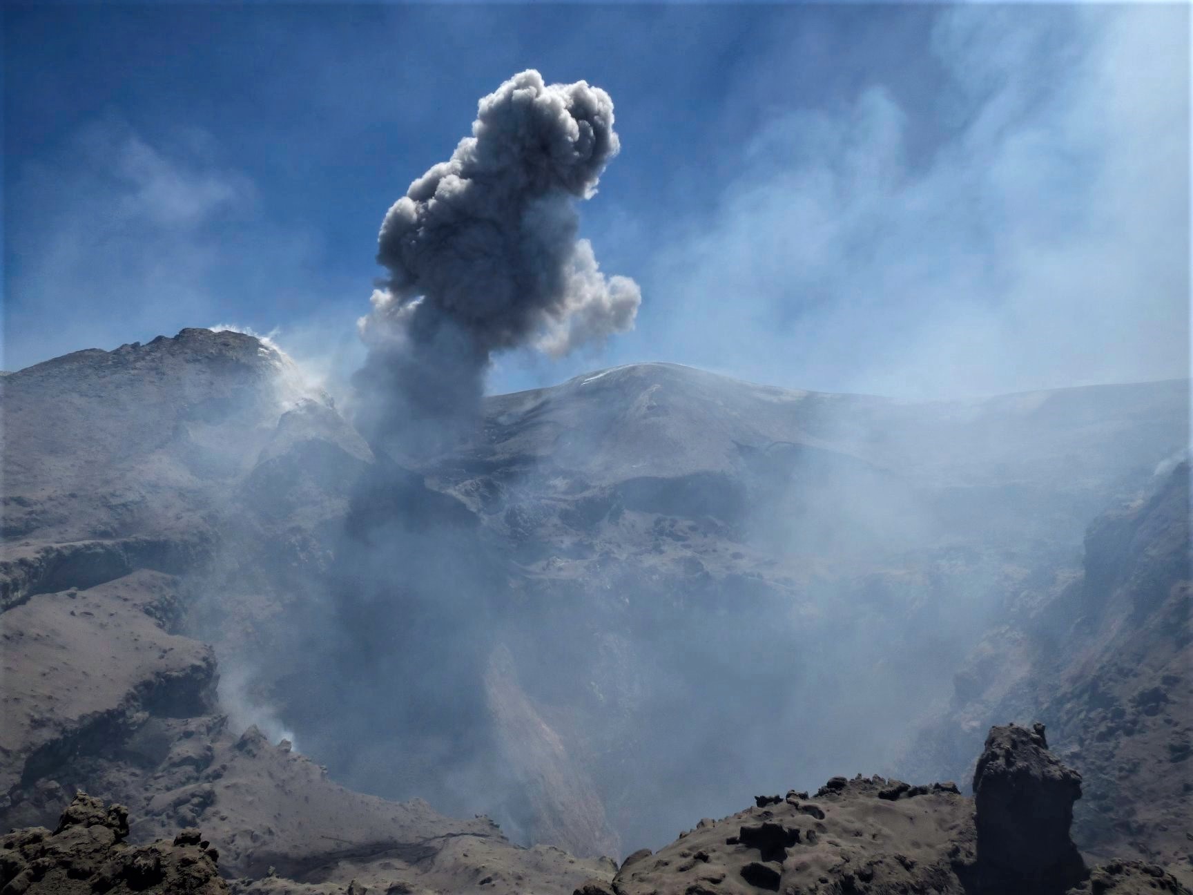
June 19, 2019. EN. Italy / Sicily : Etna , Mexico : Popocatepetl , Peru : Sabancaya / Ubinas , Colombia : Nevado del Huila .

June 19 , 2019.


Italy / Sicily , Etna :

The National Institute of Geophysics and Volcanology, Osservatorio Etneo, announced that, according to observations made during an inspection carried out in the area of the summit on June 17, 2019 and the analysis of the images recorded by the camera system monitoring of the INGV, we note the persistence of the explosive activity produced by an open eruption vent in the crater of Voragine

The explosions follow each other with irregular frequency and intensity. At 18h27 UTC on 18 June, in the summit area, there was an explosion of intensity slightly higher than that during the last 24 hours. The pyroclastic material produced by the explosion rapidly dispersed into the atmosphere to the east, mainly on the ground, near the crater area at the summit.

From the seismic point of view, the explosion at 08:27 UTC was anticipated at 08:13 UTC by two low frequency seismic transient events higher than the average amplitude recorded by most stations of the network.
The average amplitude of volcanic tremor continues to remain in low values, with no significant change in trend.

The video was captured by Montagnola’s « EMOV » video surveillance cameras, the « EMOT » thermal surveillance on the Montagnola and the « EBT » of Bronte. At first, we see one of the ash emissions of Voragine, then, at 08:27, the strongest explosion, from a different point than the previous ash puffs.

Source : INGV Vulcani.

Photo : Etna e dintorni in foto , Gio Giusa.

Video : INGV Vulcani.


Mexico , Popocatepetl 

The Popocatépetl volcano recorded a high-intensity explosion that produced a column of smoke nearly five kilometers high, to which four other explosions were added on Monday.
The National Coordination of Civil Protection indicated that the most recent explosion was recorded at 15:14, while the previous ones occurred at 6:44, 7:04 and 12:40.

June 17, 1:30 pm (June 17, 18:30 GMT)
UPDATE

At 1240, an explosion was recorded, with a height of about 8 km, with a moderate ash content that the winds dispersed to the southwest.

Possible falls of ash could occur on the populations of the state of Morelos in the municipalities of Tetela del Volcan, Ocuituco, Yecapixtla, Zacualpan, Temoac and Atlatlahucan, Edo, Mexico City, Ecatzingo, Atlautla, Ozumba and Tepetlixpa, and the state of Puebla to San Nicolás de los Ranchos, Nealtican, Tianguismanalco, San Jerónimo Tecuanipan, San Gregorio Atzompa, San Andrés Cholula, San Pedro Cholula and Pale.

Source : Publimetro , Cenapred.


Peru , Sabancaya / Ubinas :

Sabancaya Volcano:
Period of analysis: June 10 to 16, 2019
Alert level: ORANGE

The Geophysical Institute of Peru (IGP) reports that the eruptive activity of the Sabancaya volcano remains moderate. Therefore, for the following days, no significant change is expected.

The analysis of the recordings obtained from the seismic network of the Sabancaya volcano for the period from 10 to 16 June 2019 has made it possible to identify the occurrence of 2086 earthquakes of volcanic origin, the highest percentage of which is associated with the movement of magmatic fluids. During this week, an average of 13 daily explosions were recorded, of low to medium intensity.

The monitoring of the deformation of the volcanic structure using GNSS data (processed with fast orbits) does not show significant anomalies. Visual surveillance, using surveillance cameras, identified the appearance of eruptive columns reaching an altitude of 3.8 km at the summit of the volcano, whose ashes were dispersed to the eastern and southern sectors of Sabancaya. Satellite monitoring identified 7 volcanic anomalies on the volcano between 6 and 30 MW, associated with the presence of a hot body near the surface and the persistence of explosions.

Ubinas Volcano:
Period of analysis: June 18, 2019.
Alert level: GREEN

The Geophysical Institute of Peru (IGP) reports that the dynamic behavior of the Ubinas volcano has recorded during the last hours the appearance of a seismic swarm or a group of abnormal earthquakes. As a result, it is suggested that the authorities and the public remain attentive to the reports published by the IGP.

The IGP analyzed the seismic activity recorded on the Ubinas volcano on June 18, 2019, identifying between 9:45 am and 11:00 am the occurrence of 6 major earthquakes with a magnitude of less than 2.8 ML (local magnitude).  This seismicity is associated with rock breaking processes within the volcano, at a depth of about 7.5 km below it. It should be noted that no seismicity has been observed associated with the rise of the magma.

The surveillance camera did not record any fumaroles or significant changes during the current period.
Satellite monitoring using information from the SENTINEL, IMO-NASA (SO2) and MIROVA (thermal anomalies) systems showed no anomalies during the period.

Source : IGP.

Photos : Ingemmet.


Colombia , Nevado del Huila :

Weekly activity bulletin of the Nevado del Huila volcano
The level of activity of the volcano continues at the level: yellow activity level or (III): changes in the behavior of volcanic activity.

According to the analysis and evaluation of the information obtained through the surveillance network of the Nevado del Huila volcano, from 11 to 17 June 2019, the COLOMBIAN GEOLOGICAL SERVICE – Volayological and Volcanic Observatory of Popayán indicates that:

• During the evaluated period, 170 seismic events were recorded, of which 118 were related to rock fracturing processes (type VT) and 52 to fluid dynamics in volcanic canals. Of these, 48 were classified as long period type events (LP type) and 4 as low energy tremor pulses (TR type).

• The majority of localized earthquakes, associated with fracture processes, continue to be located northeast of the volcanic building, at a distance from the central peak oscillating between 11 and 19 km, with depths between 7 and 13 km.

• The images obtained during the week by the web cameras of Caloto, Tafxnú, Maravillas and La Palma showed a weak degassing of the volcanic system. On June 11, a mobile measure of SO2 emissions was carried out on the Tunía – Puerto Tejada (Cauca) road, for a total of 1214 t / day, which is considered low.

• Sensors for monitoring soil deformation, magnetic fields, and infrasound did not record any variations associated with changes in volcanic activity.

It is repeated that, although the VT seismicity located to the northeast of the Nevado del Huila volcano is in the zone of influence of this one, these events occur in an area
Tectonically active. Until now they have not affected the other parameters of volcanic monitoring; therefore, the level of activity of the volcano has not changed, which continues to Amarillo or level III.

Source : Ingeominas.

Photo : Parque Nacional


19 Juin 2019. FR. Italie / Sicile : Etna , Mexique : Popocatepetl , Perou : Sabancaya / Ubinas , Colombie : Nevado del Huila .

19 Juin 2019.


Italie / Sicile , Etna :

L’institut national de géophysique et de volcanologie, Osservatorio Etneo, a annoncé que, d’après les observations effectuées lors d’une inspection effectuée dans la zone du sommet le 17 juin 2019 et l’analyse des images enregistrées par le système de caméra de surveillance de l’INGV, on note la persistance de l’activité explosive produite par un évent éruptif ouvert dans le cratère de la Voragine.

Les explosions se succèdent avec une fréquence et une intensité irrégulières. À 18 h 27 UTC, le 18 juin, dans la zone du sommet, il y a eu une explosion d’intensité légèrement supérieure à celle survenue au cours des 24 dernières heures. La matière pyroclastique produite par l’explosion s’est rapidement dispersée dans l’atmosphère vers l’Est, principalement au sol, près de la zone du cratère au sommet.
Du point de vue sismique, l’explosion à 08h27 UTC était anticipée à 08h13 UTC par deux évènements transitoires sismiques de basse fréquence supérieurs à l’amplitude moyenne enregistrée par la plupart des stations du réseau.
L’amplitude moyenne du tremor volcanique continue de rester dans les valeurs basses, sans changement significatif de sa tendance.

La vidéo a été capturée par les caméras de surveillance visuelle « EMOV » de la Montagnola , par la surveillance thermique « EMOT » sur la Montagnola et par l’ « EBT » de Bronte. Au début, on voit l’une des émissions de cendres de la Voragine, puis, à 08h27, l’explosion la plus forte, à partir d’un point différent de celui des bouffées de cendres précédentes.

Source : INGV Vulcani.

Photo : Etna e dintorni in foto , Gio Giusa.

Video : INGV Vulcani.


Mexique , Popocatepetl 

Le volcan Popocatépetl a enregistré une explosion de grande intensité qui a produit une colonne de fumée de près de cinq kilomètres d’altitude, à laquelle se ont ajouté quatre autres explosions ce lundi.

La Coordination nationale de la protection civile a indiqué que l’explosion la plus récente avait été enregistrée à 15h14, tandis que les précédentes s’étaient produites à 6h44, 7h04 et 12h40.

17 juin, 13h30 (17 juin, 18h30 GMT)

ACTUALISATION

À 12 h 40, une explosion a été enregistrée, dont la hauteur atteignait environ 8 km, avec une teneur en cendres modérée que les vents ont dispersé vers le Sud-Ouest  .

Des chutes possibles de cendres pourraient avoir lieu sur les populations de l’état de Morelos dans les municipalités de Tetela del Volcán, Ocuituco, Yecapixtla, Zacualpan, Temoac et Atlatlahucan, de l’Edo,  de Mexico , à Ecatzingo, Atlautla, Ozumba et Tepetlixpa, et de l’État de Puebla à San Nicolás de los Ranchos, Nealtican, Tianguismanalco, San Jerónimo Tecuanipan, San Gregorio Atzompa, San Andrés Cholula, San Pedro Cholula et Pale.

Source : Publimetro , Cenapred.


Pérou , Sabancaya / Ubinas :

Volcan Sabancaya :

Période d’analyse: du 10 au 16 juin 2019
Niveau d’alerte: ORANGE

L’Institut géophysique du Pérou (IGP) rapporte que l’activité éruptive du volcan Sabancaya reste modérée. Par conséquent, pour les jours suivants, aucun changement significatif n’est attendu.

L’analyse des enregistrements obtenus du réseau sismique du volcan Sabancaya pour la période du 10 au 16 juin 2019 a permis d’identifier l’apparition de 2086 tremblements de terre d’origine volcanique, dont le pourcentage le plus élevé est associé au mouvement des fluides magmatiques. Au cours de cette semaine, en moyenne 13 explosions quotidiennes ont été enregistrées , d’intensité faible à moyenne.

Le suivi de la déformation de la structure volcanique à l’aide de données GNSS (traitées avec des orbites rapides) ne présente pas d’anomalies significatives. La surveillance visuelle, à l’aide de caméras de surveillance, a permis d’identifier l’apparition de colonnes éruptives atteignant 3,8 km d’altitude au sommet du volcan, dont les cendres ont été dispersées vers les secteurs Est et Sud-Est du Sabancaya. La surveillance par satellite a permis d’identifier, sur le volcan, la présence de 7 anomalies thermiques d’une valeur comprise entre 6 et 30 MW, associées à la présence d’un corps chaud près de la surface et à la persistance d’explosions.

Volcan Ubinas :

Période d’analyse: 18 juin 2019 .
Niveau d’alerte: VERT

L’Institut géophysique du Pérou (IGP) rapporte que le comportement dynamique du volcan Ubinas a enregistré au cours des dernières heures l’apparition d’un essaim sismique ou d’un groupe de séismes anormaux . En conséquence, il est suggéré aux autorités et à la population de rester attentives aux rapports publiés par l’IGP.

L’IGP a analysé l’activité sismique enregistrée sur le volcan Ubinas le 18 juin 2019, en identifiant, entre 9h45 et 11h00, la survenue de 6 séismes importants de magnitude inférieure à 2,8 ML (magnitude locale). . Cette sismicité est associée à des processus de rupture de roches à l’intérieur du volcan, à une profondeur d’environ 7,5 km au-dessous de celui-ci. Il convient de noter qu’aucune sismicité n’a été observée associée à la remontée du magma.
La caméra de surveillance n’a pas enregistré de fumeroles ni de modifications significatives au cours de la période en cours.

La surveillance par satellite utilisant des informations provenant des systèmes SENTINEL, OMI-NASA (SO2) et MIROVA (anomalies thermiques) ne présente aucune anomalie au cours de la période.

Source : IGP.

Photos : Ingemmet.


Colombie , Nevado del Huila :

Bulletin hebdomadaire d’activité du volcan Nevado del Huila
Le niveau d’activité du volcan se poursuit au niveau : niveau d’activité jaune ou (III): changements dans le comportement de l’activité volcanique.

D’après l’analyse et l’évaluation des informations obtenues par l’intermédiaire du réseau de surveillance du volcan Nevado del Huila, du 11 au 17 juin 2019, le SERVICE GÉOLOGIQUE COLOMBIEN – Observatoire volcanologique et sismologique de Popayán indique que :

• Au cours de la période évaluée, 170 événements sismiques ont été enregistrés, dont 118 étaient liés aux processus de fracturation de roche (type VT) et 52 à la dynamique des fluides dans les canaux volcaniques. Parmi ces derniers, 48 ​​ont été classés comme événements de type longue période (type LP) et 4 comme impulsions de tremor de faible énergie (type TR).

• La majorité des séismes localisés, associés aux processus de fracture, continuent d’être situés au Nord-Est du bâtiment volcanique, à une distance du pic central oscillant entre 11 et 19 km, avec des profondeurs comprises entre 7 et 13 km.

• Les images obtenues au cours de la semaine par les caméras Web de Caloto, Tafxnú, Maravillas et La Palma montraient un faible dégazage du système volcanique. Le 11 juin, une mesure mobile des émissions de SO2 a été réalisée sur la route Tunía – Puerto Tejada (Cauca), pour un total de 1214 t / jour, ce qui est considéré comme faible.

• Les capteurs pour la surveillance de la déformation du sol, des champs magnétiques et des ondes infrasons n’ont pas enregistré de variations associées aux changements de l’activité volcanique.

Il est répété que, bien que la sismicité VT située au Nord-Est du volcan Nevado del Huila soit dans la zone d’influence de celui ci, ces événements se produisent dans une zone
Tectoniquement active . Ils n’ont pas affecté jusqu’à présent les autres paramètres de la surveillance volcanique; par conséquent, le niveau d’activité du volcan n’a pas été modifié, qui se poursuit à Amarillo ou au niveau III.

Source : Ingeominas.

Photo : Parque Nacional