
May 24 , 2018.
Pu’u ‘Ō’ō / Kilauea , Hawai :
Tuesday, May 22, 2018, 10:22 PM HST (Wednesday, May 23, 2018, 08:22 UTC)
19°25’16 » N 155°17’13 » W,
Summit Elevation 4091 ft (1247 m)
Current Volcano Alert Level: WARNING
Current Aviation Color Code: RED
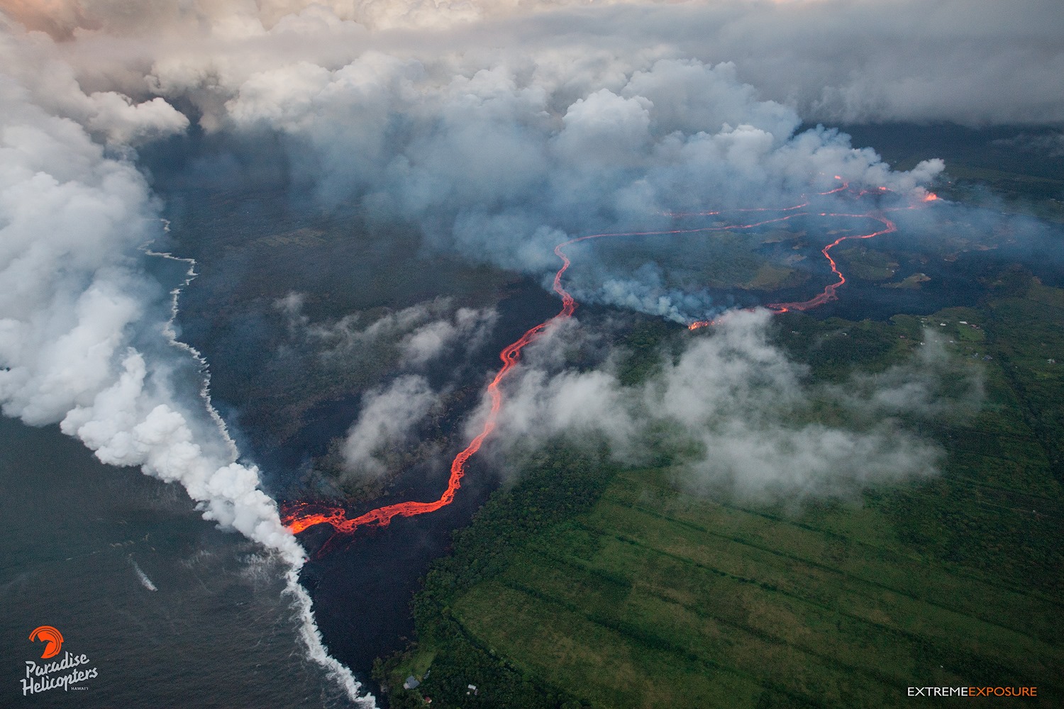
Kīlauea Volcano Lower East Rift Zone
Eruption of lava and ground cracking continues in the area of Leilani Estates subdivision.
Over the course of the day, the most active eruptive activity in the Lower East Rift Zone shifted to the middle portion of the system of fissures. The most active fissures were 22,19, 6, 5, and 23. Fissure 17, at the northeastern end of the fissure system is only weakly active now. Fissure 6 is feeding a flow to the south, roughly parallel to the western flow from fissure 22. Fountaining of fissures 5 and 23 fed flows in the eastern part of Leilani Estates.
20180522 @ 19:30 HST – Fissure 15 ,19, and 22 from Andrew Richard Hara on Vimeo.
Additional ground cracking and outbreaks of lava are possible in the area. Residents downslope of the region of fissures should heed all Count of Hawaii Civil Defense messages and warnings.
Magma continues to be supplied to the lower East Rift Zone. Elevated earthquake activity continues, but earthquake locations have not moved farther downrift in the past couple of days, and there were only a few earthquakes located today in the rift zone.
USGS/HVO continues to monitor the lower East Rift Zone activity 24/7 in coordination with Hawaii County Civil Defense, with geologists onsite to track ongoing and new fissure activity and the advance of lava flows.
Kīlauea Volcano Summit
Small ash emissions from the Overlook crater have been occurring frequently today. Moderate trade winds were blowing to the southwest and noticeable ashfall may happen in downwind locations.
Additional explosive events that could produce minor amounts of ashfall downwind are possible at any time. Volcanic gas emissions at the summit remain high.
Wednesday, May 23, 2018, 6:05 AM HST (Wednesday, May 23, 2018, 16:05 UTC)
Kīlauea Volcano Lower East Rift Zone
Eruption of lava and ground cracking continues in the area of Leilani Estates and Lanipuna Gardens subdivision.
The middle portion of the fissure system continues to produce the most robust eruptive activity in the Lower East Rift Zone. The most active fissures have been 22,19, 6, 5, and 23. A faint glow was seen from Fissure 9, but no flows, and methane was observed burning in road cracks overnight. The ocean entry remains active and is producing occasional small explosions. Observers noted the height of the perched lava pond / channel had reached 11 meters / 36 feet above the ground level.
Lava is probably still entering the ocean. Although we can’t get visual confirmation until after dawn, instrumental signals are consistent with continuing ocean entry activity.
Volcanic gas emissions remain very high from these fissure eruptions.
Additional ground cracking and outbreaks of lava are possible in the area. Residents downslope of the region of fissures should heed all Hawaii County Civil Defense messages and warnings.
Magma continues to be supplied to the lower East Rift Zone. Elevated earthquake activity continues, but earthquake locations have not moved farther downrift in the past couple of days, and there were only a few earthquakes located yesterday in the rift zone.
USGS/HVO continues to monitor the lower East Rift Zone activity 24/7 in coordination with Hawaii County Civil Defense, with geologists onsite to track ongoing and new fissure activity and the advance of lava flows.
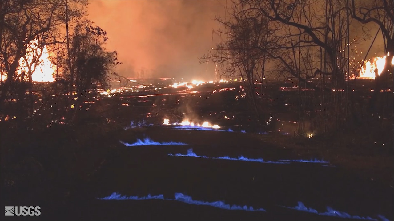
(USGS) A blue burning flame of methane gas was observed in the cracks on Kahukai Street during the overnight hours. When lava buries plants and shrubs, methane gas is produced as a byproduct of burning vegetation. Methane gas can seep into subsurface voids and explode when heated, or as shown in this video, emerge from cracks in the ground several feet away from the lava. When ignited, the methane produces a blue flame.
Kīlauea Volcano Summit
Small ash emissions from the Overlook crater occurred frequently throughout the night. Moderate trade winds were blowing to the southwest and ashfall may be noticed in downwind locations. Earthquakes in the summit area continue at a moderate rate, as does deflation of the summit region.
Additional explosive events that could produce minor amounts of ashfall downwind are possible at any time. Volcanic gas emissions at the summit remain high.
Wednesday, May 23, 2018, 4:47 PM HST (Thursday, May 24, 2018, 02:47 UTC)
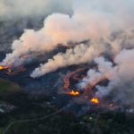
LOWER EAST RIFT ZONE
Moderate-level eruption of lava continues from multiple points along the central and northeast end of the active fissure system. Residents in lower Puna should remain informed and heed Hawaii County Civil Defense closures, warnings, and messages (http://www.hawaiicounty.gov/active-alerts)
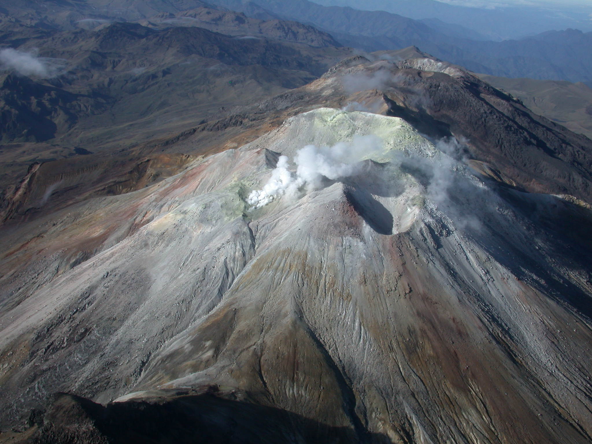
Fissure 6 through 22 continue erupting lava fountains. The fountains from Fissure 22 feed a single lava channel that reaches the coast just north of MacKenzie State Park. The actual point of entry has continued shifting to the west. Fountains erupted from Fissures 5, 6, 13, and 19 continued to feed a lava flow advancing to the south along the west side of the Fissure 22 flows and may reach the ocean this afternoon or evening. Fissure 17 continue weak spattering, Fissure 8 reactivated briefly this morning to erupt two small pahoehoe flows over the initial `a`a flow.
HVO field crews are on site tracking the lava flows and spattering from multiple fissures as conditions allow and reporting information to Hawaii County Civil Defense.
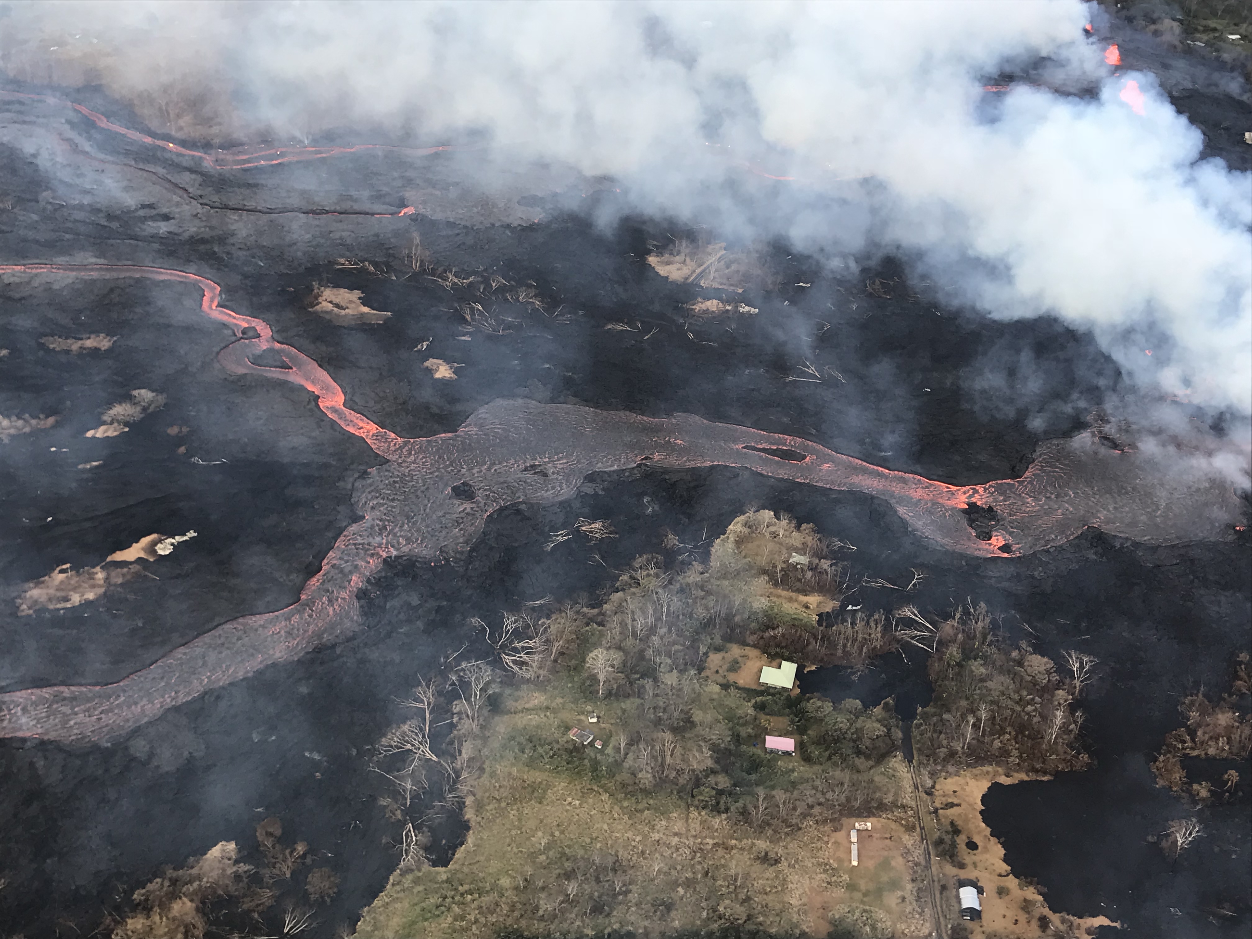
Helicopter overflight of Kīlauea Volcano’s lower East Rift Zone shows the lava channel emerging from Fissure 22 (not visible, but to the center, far right of the image). The lava is flowing downhill, from right to left in the photo
Volcanic gas emissions have tripled as a result of the voluminous eruptions from the erupting fissures so SO2 concentrations are likely elevated to higher levels throughout the area downwind of the vents. Moderate trade winds today means that areas downwind of Kilauea gas emission sources may experience varying levels of vog.
This eruption is still evolving and additional outbreaks of lava are possible. Ground deformation has slowed and seismicity levels have decreased in the area.
Future outbreaks could occur both uprift (southwest) and downrift (northeast) of the existing fissures, or, existing fissures can be reactivated. Communities downslope of the fissure system could be at risk from lava inundation. Activity can change rapidly.
Conditions around the erupting fissures can change very quickly. Residents in lower Puna should remain informed and heed Hawaii County Civil Defense closures, warnings, and messages (http://www.hawaiicounty.gov/active-alerts).
KILAUEA SUMMIT
Multiple small eruptions of ash occurred over the past day, all ejecting ash to under 10,000 ft above sea level. One of the largest occurred about 10:30 this morning. Additional explosions are possible at any time.
Seismic levels, which abruptly decreased after the recent explosive eruptions, are again slowly increasing.
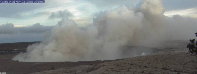
At this time, based on HVO web cameras, a robust plume of gas and steam is billowing out of the Overlook vent and drifting generally southwest.
At any time, activity may again become more explosive, increasing the intensity of ash production and producing ballistic projectiles very near the vent. Communities downwind should be prepared for ashfall as long as this activity continues.
Source : HVO
Photos : Bruce Omori.
Vidéo : Andrew Richard Hara / Vimeo.
Cumbal , Colombia :
Subject: Cumbal Volcano Activity Bulletin.
The level of activity of the volcano is maintained at the level:
YELLOW LEVEL ■ (III): CHANGES IN THE BEHAVIOR OF VOLCANIC ACTIVITY.
Following the activity of the CUMBAL VOLCANIC COMPLEX, the COLOMBIAN GEOLOGICAL SERVICE informs that:
For the period of May 15, 2018, low levels of occurrence and energy level of the seismic activity are maintained, with values similar to those recorded in previous weeks, mainly earthquakes related to the movements fluids inside the volcanic system, followed by those associated with the fracturing of rocks inside the volcano. The fracture events were scattered around the volcano, mainly near the crater La Plazuela (on the north side of the Cumbal volcanic complex) at distances of less than 6 km, and up to a depth of 3 km from at the volcanic peak (reference level at 4700 m) and a maximum local magnitude of M0.4 on the Richter scale.
Favorable weather conditions have seen most of the week emissions of volcanic gases mainly from the field of fumaroles El Verde (northeast of the volcanic complex). The emission columns were observed in white color, low height and variable dispersion direction in the prevailing wind direction
The COLOMBIAN GEOLOGICAL SERVICE is attentive to the evolution of the volcanic phenomenon and will continue to inform in a timely manner about the detected changes
Source : SGC
Merapi , Indonesia :
VOLCANO OBSERVATORY NOTICE FOR AVIATION – VONA.
Issued: May 23 , 2018.
Volcano: Merapi (263250)
Current Aviation Colour Code: ORANGE
Previous Aviation Colour Code: orange
Source: Merapi Volcano Observatory
Notice Number: 2018MER06
Volcano Location: S 07 deg 32 min 31 sec E 110 deg 26 min 31 sec
Area: Special Region of Yogyakarta, Indonesia
Summit Elevation: 9498 FT (2968 M)
Volcanic Activity Summary:
Eruption at 06h49 UTC (13h49 local). Eruption has deceased.
Volcanic Cloud Height:
Ash cloud not visible.
Other Volcanic Cloud Information:
Ash-cloud moving to south-west.
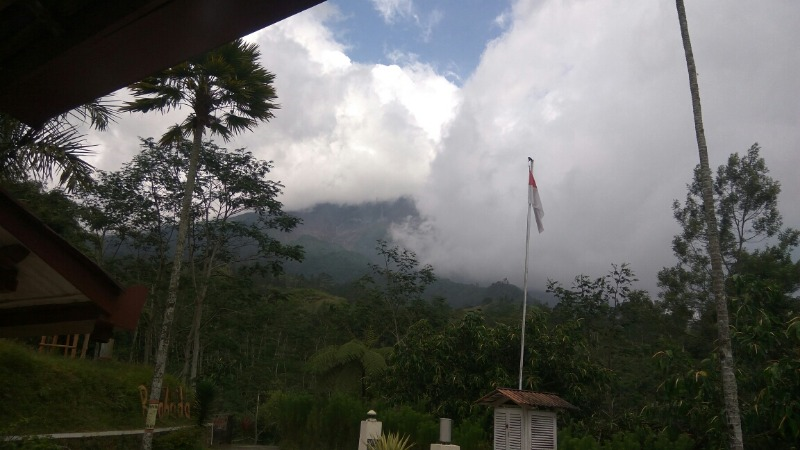
Water eruption at 1:49 pm with a maximum amplitude of 50 mm and a duration of 2 minutes. Heard of Post PGM from Babadan but the eruption column was not observed because of the mist above the PGM. There is a fine shower of ash around Post Ngepos – Kab. Magelang.
State of alert: WASPADA
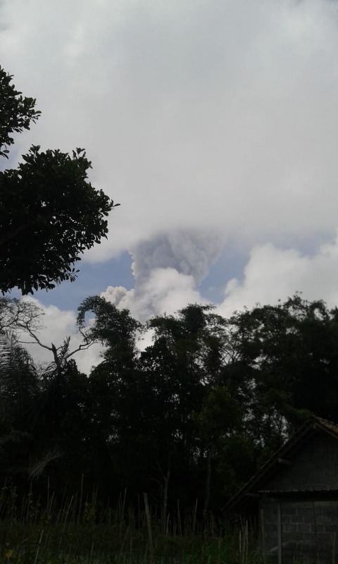
May 24, 2018.
Eruption of the Merapi at 14:56, elevation of 6,000 m, maximum amplitude of 60 mm, direction of dispersion of the column to the west, duration for 4 minutes and heard the roar of all observation posts on Mount Merapi
Source : Magma , VSI
Piton de la Fournaise , La Réunion :
Activity Bulletin from Wednesday, May 23, 2018 at 17:00 (local time).
The eruption started on April 27, 2018 at 23:50 local time continues. The intensity of the volcanic tremor (indicator of the eruptive intensity at the surface) continues its progressive decay.
– Rainy weather was maintained on the south of the pen all day making observations difficult (60 mm in the last 24 hours). As a result, no on-site observations have been made today.
– Surface discharges could not be estimated from satellite data in the last 24 hours due to cloud cover on the volcano.
– The inflation of the building continues.
– No volcano-tectonic earthquake has been recorded during the last 24 hours under the Piton de la Fournaise volcano.
Alert level: Alert 2-2 – Eruption in the Enclos
Source : OVPF
Photo : Fournaise Info.
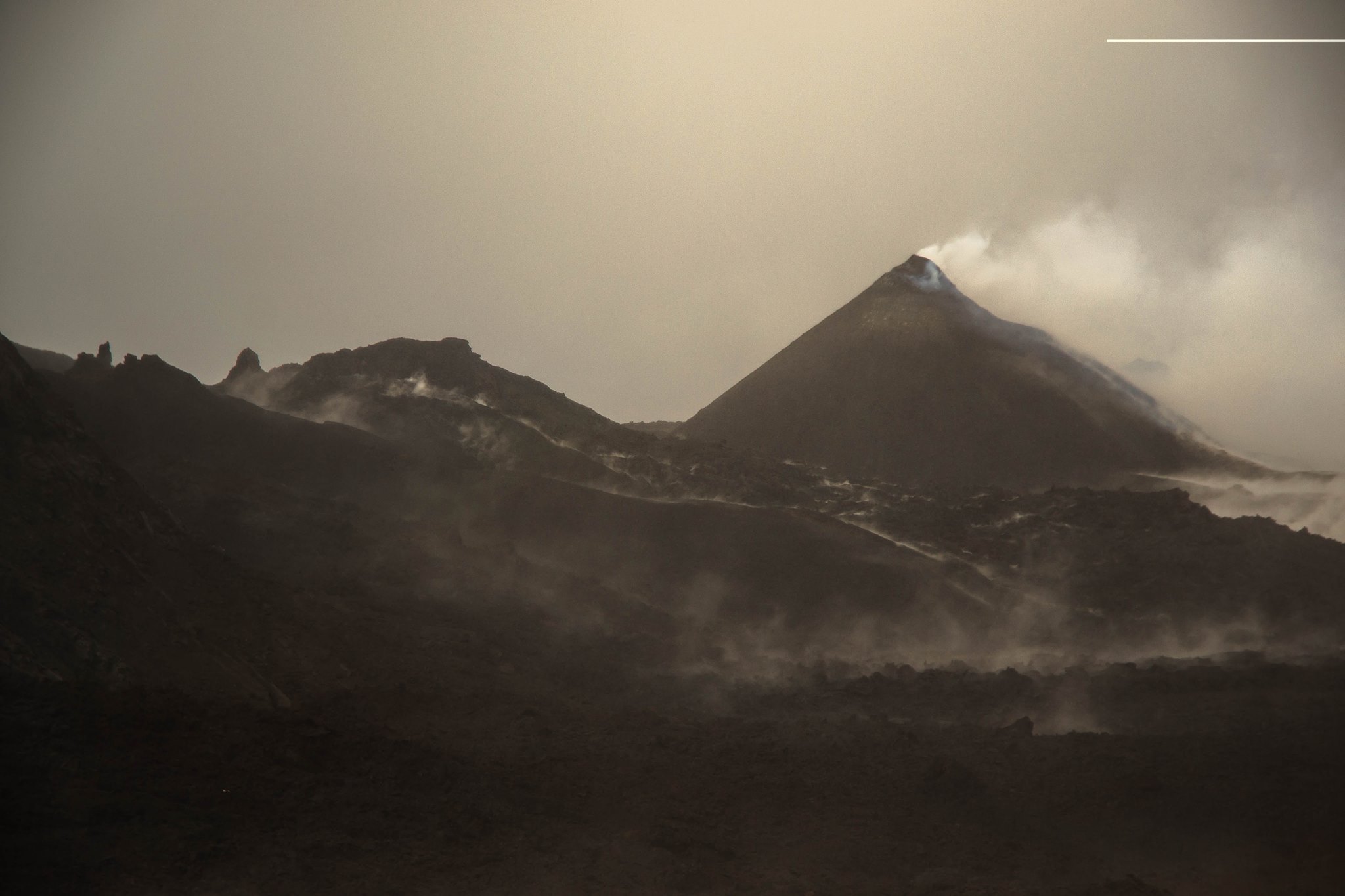
Klyuchevskoy , Kamchatka :
56.06 N, 160.64 E;
Elevation 15580 ft (4750 m)
Aviation Colour Code is ORANGE
A heightened activity of the volcano continues. Ash explosions up to 26,240 ft (8 km) a.s.l. could occur at any time. Ongoing activity could affect international and low-flying aircrafts.
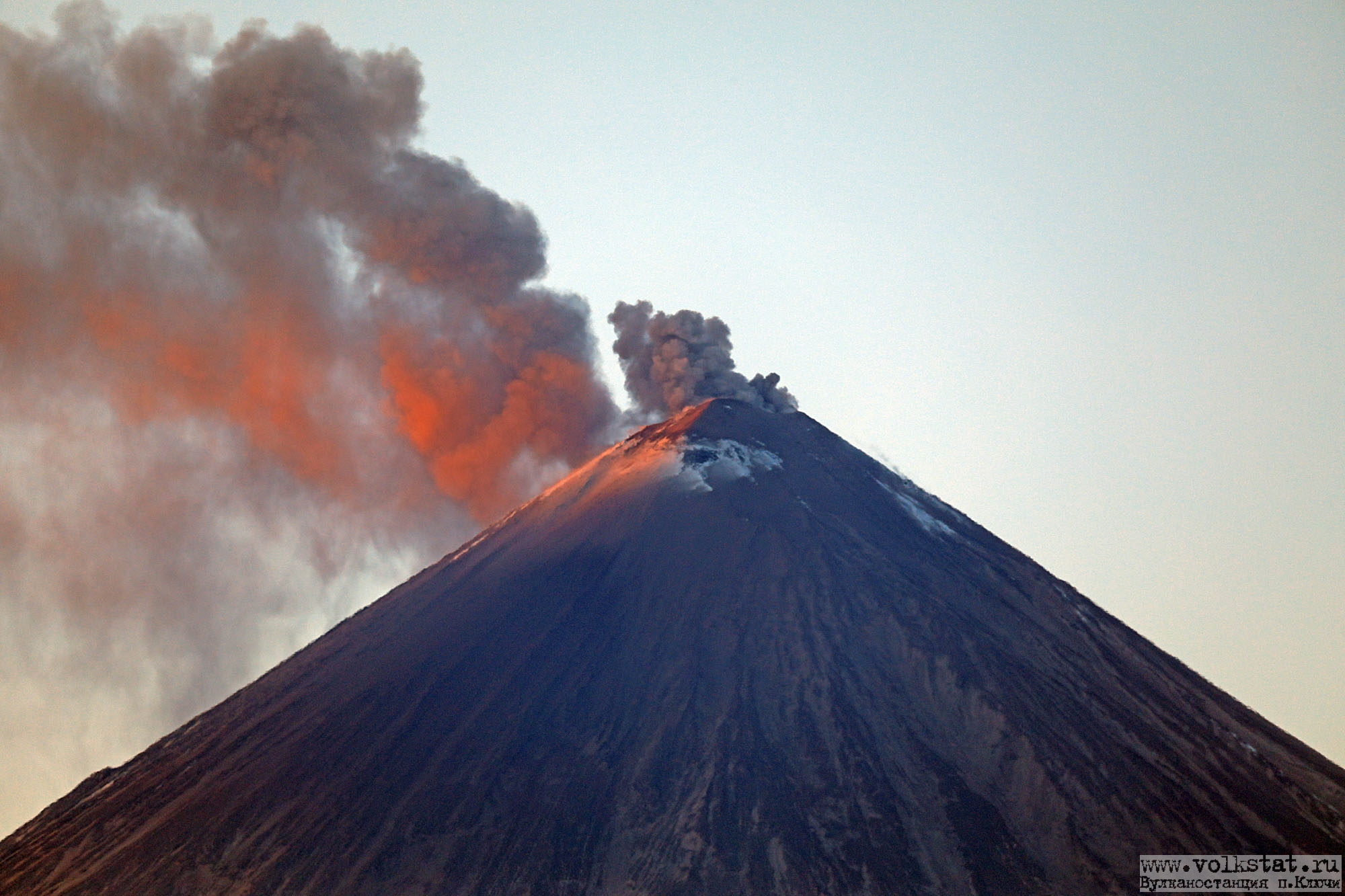
A heightened activity of the volcano continues. According to visual and satellite data, a strong event occurred at 15h15 UTC on 14 May: explosions sent ash up to 10.5 km a.s.l., ash clouds was staying for about 8 hours over Klyuchevskaya group of volcanoes, gradually dissipating. A hot avalanche and an incandescence of the volcanic summit at night were noted. Short gas-steam plumes containing small amount of ash sometimes were detected last week. A thermal anomaly over the volcano was noted on 13-15 May, the volcano was obscured by clouds in the other days of week.
Source : Kvert
Photo : Yu Demyanchuck , Volkstat ru , 18/01/2018.


No comment yet, add your voice below!