
May 04 , 2018.
Pu’u ‘Ō’ō / Kilauea , Hawai :
HVO/USGS Volcanic Activity Notice
Current Volcano Alert Level: WARNING
Previous Volcano Alert Level: WATCH
Current Aviation Color Code: ORANGE
Issued: Thursday, May 3, 2018, 5:35 PM HST
Source: Hawaiian Volcano Observatory
Notice Number:
Location: N 19 deg 25 min W 155 deg 17 min
Elevation: 4091 ft (1247 m)
Area: Hawaii

Volcanic Activity Summary:
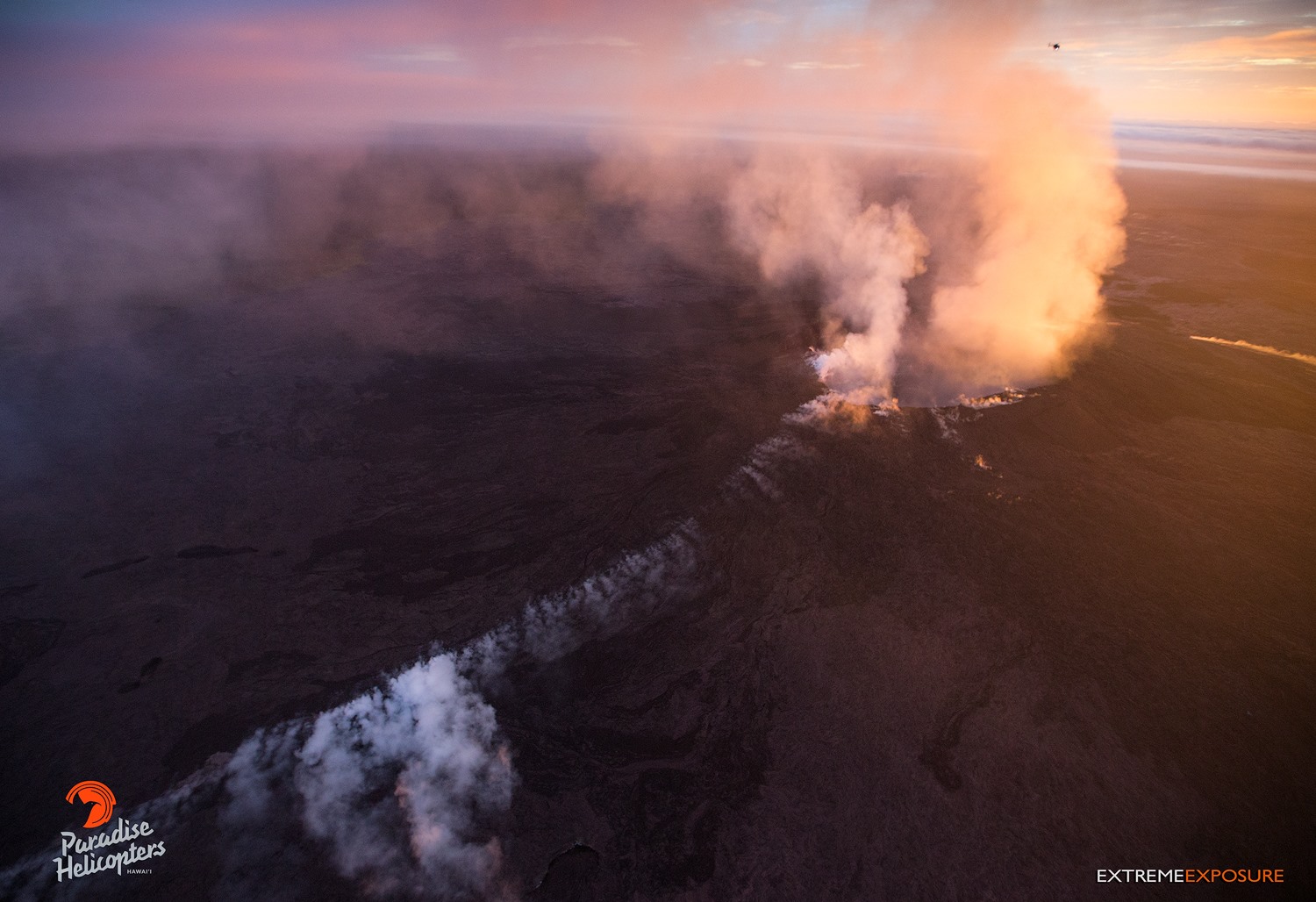
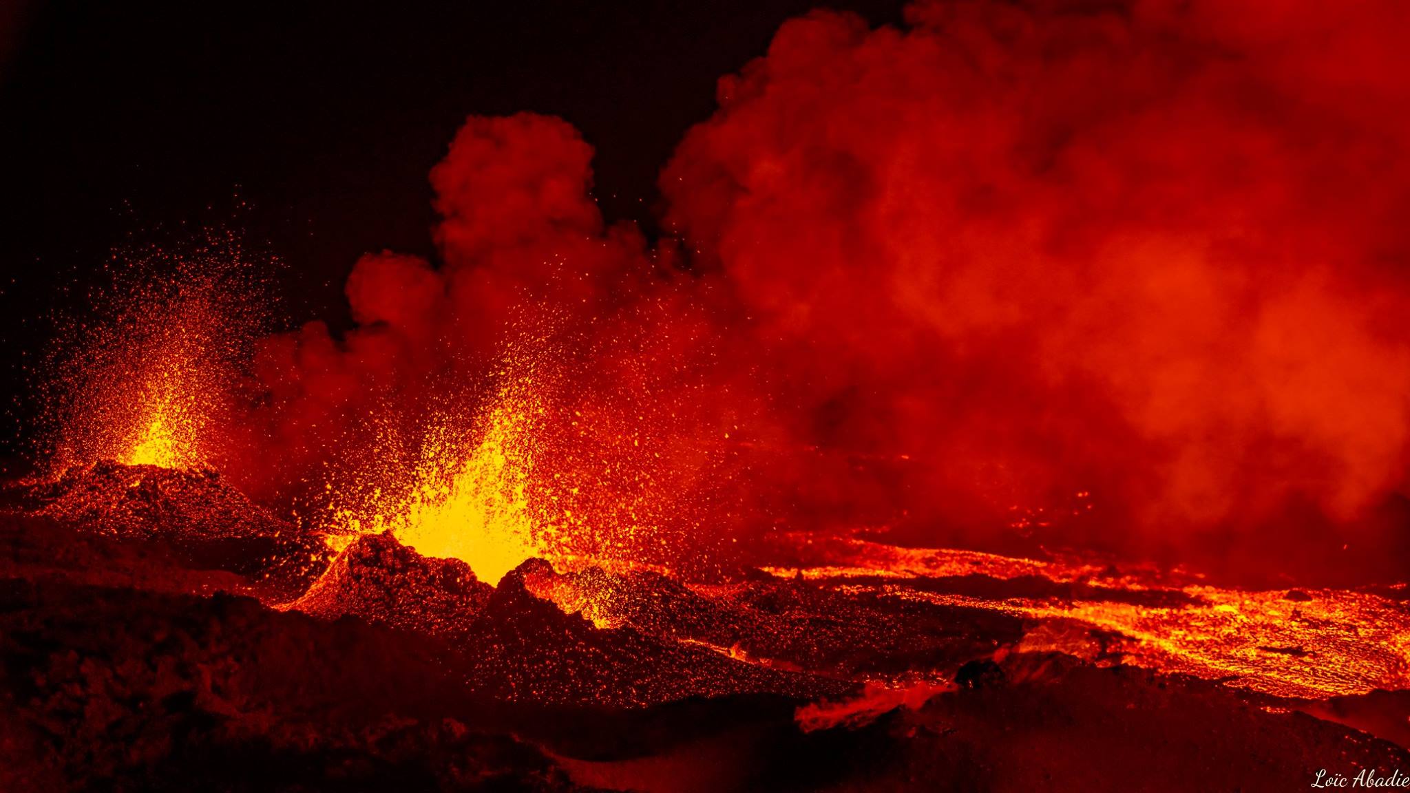
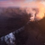
An eruption has commenced in the Leilani Estates subdivision in the lower East Rift Zone of Kilauea Volcano. Shortly before 5 pm, lava was confirmed at the surface in the eastern end of the subdivision. Hawaii County Civil Defense is on scene and coordinating needed response including evacuation of a portion of the Leilani subdivision.
Residents of the lower Puna District should remain alert, review individual, family, and business emergency plans, and watch for further information about the status of the volcano. Hawaii County Civil Defense messages may be found at http://www.hawaiicounty.gov/active-alerts/.
Recent Observations:
New ground cracks were reported in Leilani Estates late this afternoon. White, hot vapor and blue fume emanated from an area of cracking in the eastern part of the subdivision. Spatter began erupting shortly before 5 pm.
HVO and the County of Hawaii are on the ground and conducting overflights to further identify characterize activity and identify the direction of flowing lava.
Hazard Analysis:
Areas downslope of the erupting vent are at risk of lava inundation. At this time, the general area of the Leilani subdivision appears at greatest risk.
The opening phases of fissure eruptions are dynamic. Additional vents and new lava outbreaks may occur and at this time it is not possible to say where new vents may occur.
Remarks: USGS Hawaiian Volcano Observatory scientists continue to closely monitor the activity. More updates will follow as information becomes available.
HAWAIIAN VOLCANO OBSERVATORY STATUS REPORT
U.S. Geological Survey
Thursday, May 3, 2018, 11:15 AM HST (Thursday, May 3, 2018, 21:15 UTC)
19°25’16 » N 155°17’13 » W,
Summit Elevation 4091 ft (1247 m)
Current Volcano Alert Level: WATCH
Current Aviation Color Code: ORANGE
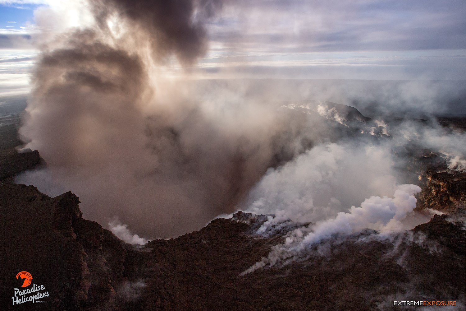
At 10:30 HST, ground shaking from a preliminary magnitude-5.0 earthquake south of Pu’u ‘Ō’ō caused rockfalls and possibly additional collapse into the Pu’u ‘Ō’ō crater on Kīlauea Volcano’s East Rift Zone.
A short-lived plume of ash produced by this event lofted skyward and is continuing to dissipate as it drifts southwest from Pu’u ‘Ō’ō. Anyone downwind may experience a dusting of ash.
At this time, the 10:30 earthquake has caused no other changes at Kīlauea Volcano. HVO will continue to closely watch monitoring data for any changes.
HVO has field crews working along the rift zone at this time. HVO will post additional information and photographs later today.
HAWAIIAN VOLCANO OBSERVATORY DAILY UPDATE
U.S. Geological Survey
Thursday, May 3, 2018, 8:48 AM HST (Thursday, May 3, 2018, 18:48 UTC)
19°25’16 » N 155°17’13 » W,
Summit Elevation 4091 ft (1247 m)
Current Volcano Alert Level: WATCH
Current Aviation Color Code: ORANGE
Summary: Earthquakes and deformation of the ground related to intrusion of magma into the lower East Rift Zone of Kilauea continue. Deflationary tilt at the summit of the volcano has been accompanied by a drop in the level of the lava lake in Halema’uma’u.
Lower East Rift Zone:
Elevated earthquake activity continues in the area of Kīlauea Volcano’s East Rift Zone from Highway 130 eastward towards Kapoho. The intensity of seismicity has diminished slightly overnight and the trend of eastward migration of earthquake activity appears to have slowed or ceased. No shallowing of earthquakes has been detected. HVO’s GPS station in the area continues to show motion related to ground deformation in response to the ongoing intrusion.
Cracks found in a number of roads in Leilani Estates yesterday likely reflect stresses due to ground deformation caused by the ongoing intrusion. No high temperatures or steam or gas were reported associated with any of the observed cracks. Hawaii County Department of Public Works reported that the crack across Pohoiki Road stopped opening last night at about 10 pm.
Although the intensity of seismicity has reduced somewhat, earthquake rates remain elevated and deformation of the ground continues. Activity could intensify at any time and an outbreak of lava in a new location along the East Rift Zone remains possible. Based on the location of the most recent seismicity and deformation, the region downrift of Puʻu ʻŌʻō, including the area east of Highway 130, remains the most likely location should an outbreak occur.
Hawaii County Civil Defense and the USGS Hawaiian Volcano Observatory advise residents of the Puna District to remain alert, review individual, family, and business emergency plans, and watch for further information about the status of the volcano. Hawaii County Civil Defense messages may be found at http://www.hawaiicounty.gov/active-alerts/.
Summit Observations: Deflationary tilt at the summit accelerated midday yesterday and is continuing this morning. In concert, the summit lava lake dropped over 30 m (100 ft). Tremor amplitude is fluctuating with lava lake spattering. Elevated summit sulfur dioxide emission rates persist. Gas emissions remain elevated.
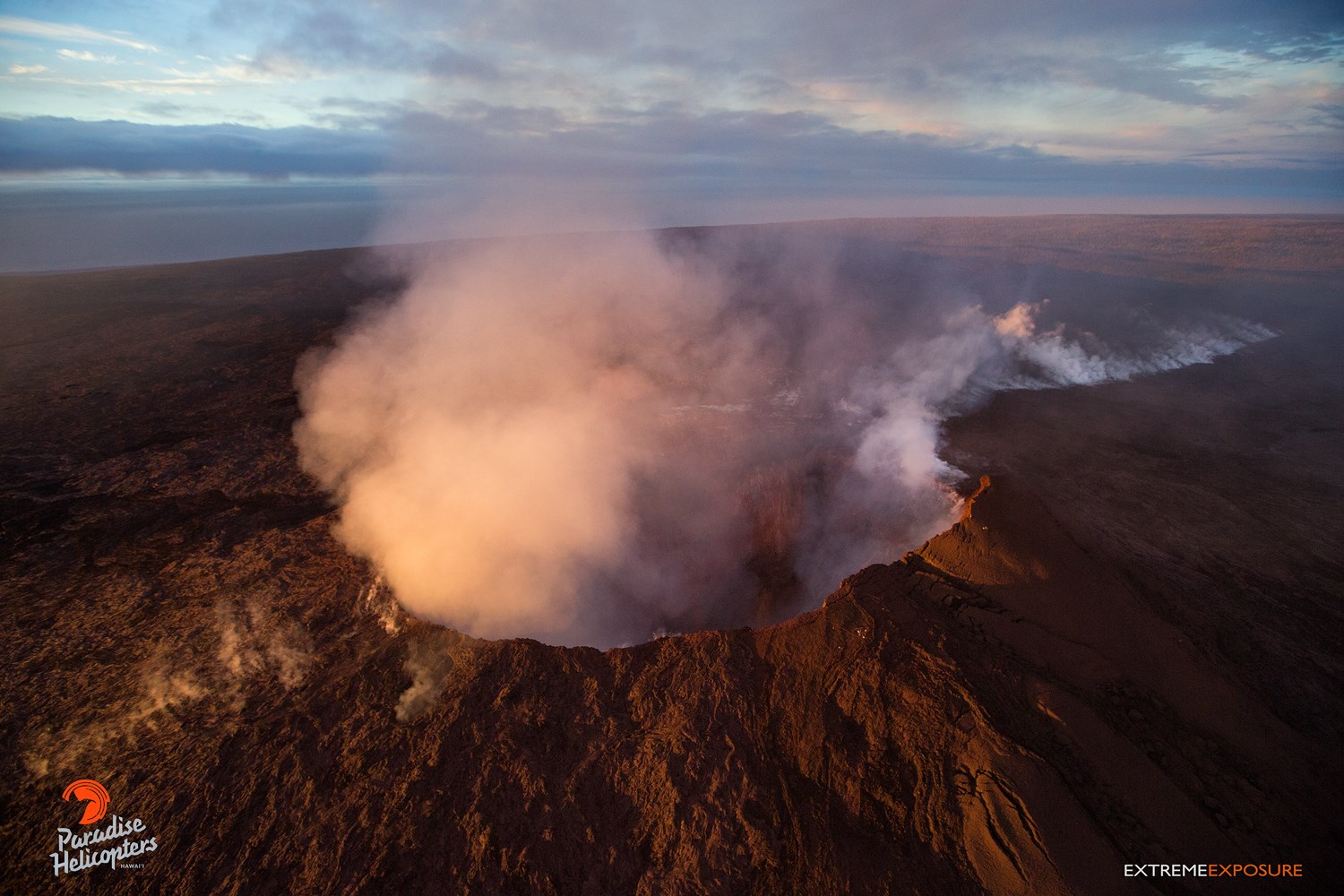
Puʻu ʻŌʻō Observations: Seismicity remains elevated at Puʻu ʻŌʻō but tiltmeters near the cone show no significant deformation overnight. HVO field crews will visit the area today to investigate the impacts of Monday’s collapse and assess the condition of HVO monitoring equipment. Watch the HVO web site for photos posted later today.
Lava Flow Observations: Today, HVO field crews will assess any continuing surface activity related to the 61g lava flow in the aftermath of Monday’s changes at the Puʻu ʻŌʻō vent. As of yesterday, only scattered, sluggish lava flow activity continued on the pali near the Royal Gardens subdivision. This activity does not pose a threat to nearby communities at this time. There is no lava flow activity on the coastal plain and no lava is flowing into the ocean. Areas of the upper flow field with active lava flows are located within the Kahaualeʻa Natural Area Reserve, which has been closed to the public by DLNR since 2007 due to volcanic hazards. Webcam views of the flow field are available here: https://volcanoes.usgs.gov/volcanoes/kilauea/multimedia_webcams.html. Maps of the lava flow field can be found here: https://volcanoes.usgs.gov/volcanoes/kilauea/multimedia_maps.html. For more info about the Kahaualeʻa NAR closure, please visit: https://dlnr.hawaii.gov/ecosystems/nars/hawaii-island/kahaualea-2.
Lava Flow Field and Ocean Entry Hazards: Hazards of active or recent lava flows include, but are not limited to, (1) hot lava surfaces that can cause serious burns upon contact with unprotected or exposed skin, (2) rough, uneven, and sharp terrain that can lead to falls, abrasions, lacerations, and other injuries, (3) high air temperature and humidity that can lead to dehydration or heat exhaustion, and (4) steamy ground-fog produced by heavy rain falling (sometimes with little warning) on active or recent lava flows; this steam can severely limit visibility, can be acidic, and should be avoided.
No services are available on the lava flow field and cell reception is limited.
Source : HVO
Photos / vidéo : Bruce Omori ( Extreme Exposure Fine Art Gallery.)
Piton de la Fournaise , La Réunion :
Activity Bulletin from Thursday, May 3, 2018 at 4:00 pm (local time).
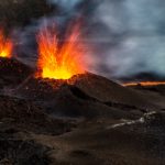
The eruption started on April 27, 2018 at 23:50 local time continues. The intensity of the volcanic tremor (indicator of surface eruptive intensity) is still relatively stable (Figure 1).
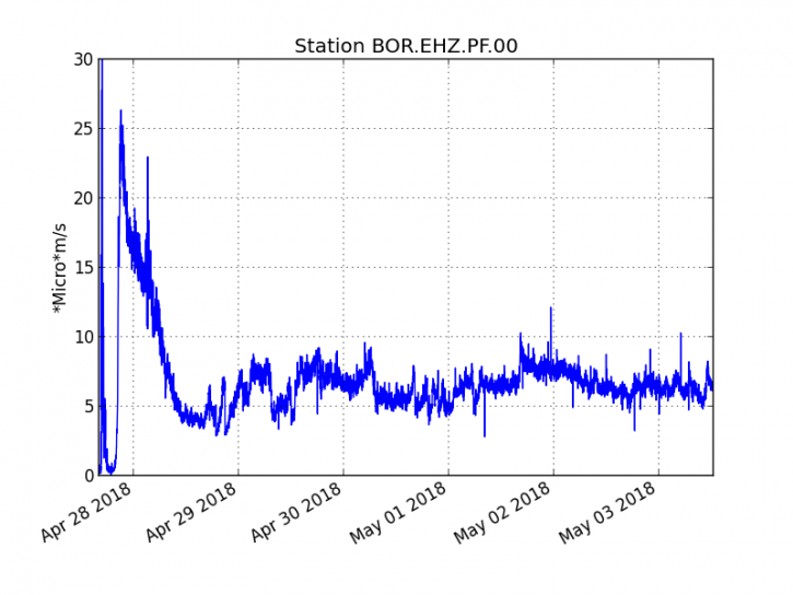
Figure 1: Evolution of the RSAM (indicator of the volcanic tremor and the intensity of the eruption) between 20:00 (16:00 UTC) on April 27 and 16:00 (12:00 UTC) May 3 at the BOR seismic station (located at the top) . (© IPGP / OVPF)
– The surface flows estimated from the satellite data, via the HOTVOLC platform (OPGC – Clermont Ferrand), recorded today were of the order of 1 m3 / s. It should be noted that these measures are only partial as a result of the bad weather conditions on the Fournaise massif during the last 24 hours.
– A very slight deflation (deflation) of the volcano continues to be recorded on the deformation sensors of the OVPF. This parameter will be followed in the next few days.
– No volcano-tectonic earthquake has been recorded in the last 24 hours under the Piton de la Fournaise building.
– Field observations made at the beginning of the afternoon showed an evolution of the surface activity compared to the previous days:
* The activity is now focused mainly on the central mouth,
* The most upstream cone shows only sporadic activity,
* The cone around the active (central) mouth is now closed.
The end of the casting was in the clouds, and could not be observed.
Alert level: Alert 2-2 – Eruption in the Enclos.
Source : OVPF
Photo : Loic Abadie
Yellowstone , United – States :
44°25’48 » N 110°40’12 » W,
Summit Elevation 9203 ft (2805 m)
Current Volcano Alert Level: NORMAL
Current Aviation Color Code: GREEN
Recent work and news:
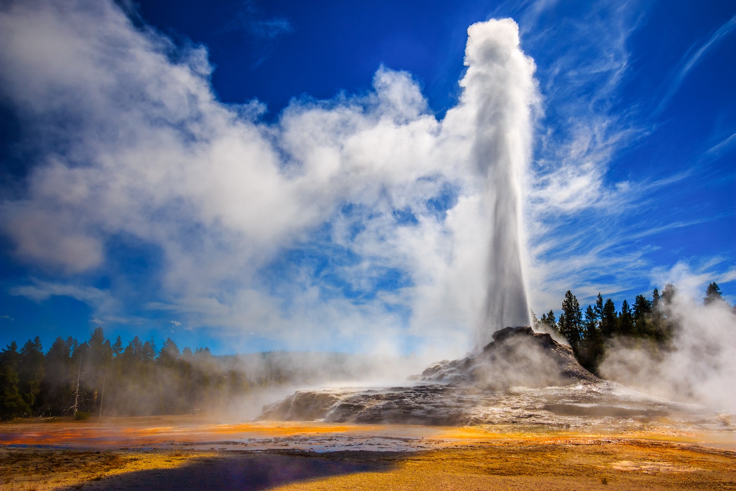
During April, Steamboat Geyser, widely acknowledged as the tallest geyser in the world, in the Norris Geyser Basin erupted twice — on April 19 at about 4:30 PM, and on April 27 at about 6:30 AM. The sporadically active geyser has now erupted 3 times in the past 6 weeks. Based on seismic data, all three eruptions have been smaller than the major events of 2013 and 2014, but these 2018 eruptions each still discharged about 10 times more water than a typical eruption of Old Faithful. Although a bit unusual, such frequent eruptions are not unique. Steamboat behaves randomly. It experienced five eruptions in 2002-2003 and dozens of eruptions during 1982-1984, but the geyser can also go dormant for years at a time. The recent activity has no bearing on the potential for a volcanic eruption, the probability of which remains remote. Geyser activity reflects only the conditions in the upper few tens of meters of the surface.

Steamboat geyser in the steam phase of eruption on March 16, 2018. the steam phase usually follows a few- to tens-of-minutes water phase and can last for hours to days. National Park Service photograph by Behnaz Hosseini.
The biennial Yellowstone Volcano Observatory (YVO) coordination meeting will take place May 7-8 in Mammoth Hot Springs, WY, and will include representatives from nearly all YVO consortium member agencies. In addition to the scientific aspects of the meeting, a public forum will be held at the community center in Gardiner, MT, on Monday, May 7, at 6:30-8:00 PM MDT. The session will feature a short panel discussion with scientists from different YVO member institutions, followed by an open question and answer period during which visitors can interact informally with YVO researchers.
Seismicity:
During April 2018, the University of Utah Seismograph Stations, responsible for the operation and analysis of the Yellowstone Seismic Network, located 200 earthquakes in the Yellowstone National Park region. The largest event was a minor earthquake of magnitude 2.7 that occurred about seven miles north of West Yellowstone, MT, on April 07 at 03:40 AM MDT. No earthquakes were reported « felt » in the Yellowstone region in April.
A swarm of 115 earthquakes was located about 8 miles east of West Thumb, WY, during April 11-16. The largest swarm earthquake, a magnitude 2.4 event, occurred on April 11 at 10:06 AM MDT.
Activity continued in the area of last summer’s Maple Creek swarm, with 48 April earthquakes. This persistent seismicity includes the largest event of the month (the aforementioned magnitude 2.7 earthquake on April 07).
Earthquake sequences like these are common and account for roughly 50% of the total seismicity in the Yellowstone region.
Yellowstone earthquake activity remains at background levels.
Ground deformation:
Subsidence of all parts of Yellowstone caldera continued throughout April at rates of a few centimeters per year — a pattern that has been ongoing since 2015. Deformation rates in the area of Norris Geyser Basin, measured by station NRWY, have been very low over the past month, with no significant uplift or subsidence.
An example of GPS data can be found at http://www.unavco.org/instrumentation/networks/status/pbo/data/NRWY (click on Static Plots / Cleaned)
The Yellowstone Volcano Observatory (YVO) provides long-term monitoring of volcanic and earthquake activity in the Yellowstone National Park region. Yellowstone is the site of the largest and most diverse collection of natural thermal features in the world and the first National Park. YVO is one of the five USGS Volcano Observatories that monitor volcanoes within the United States for science and public safety.
Source : YVO
Kirishimayama , Kyushu , Japan:
31.934°N, 130.862°E
Elevation 1700 m
JMA reported that a very small explosion at Iwo-yama (also called Ioyama, NW flank of Karakuni-dake), a stratovolcano of the Kirishimayama volcano group, occurred at 1815 on 26 April and produced a milky white plume that rose over 200 m.
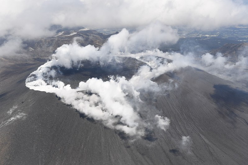
The event continued until around 1826. The event occurred from a fumarole in the vicinity of the highway, on the W side of Iwo-yama, first observed on 20 April. During a field survey on 30 April observers noted muddy water flowing as far as 500 m W. The Alert Level remained at 3 (on a scale of 1-5).
Source: Japan Meteorological Agency (JMA).
Photo : Shinmoedake


No comment yet, add your voice below!