
February 03 , 2018.
Mayon , Philippines :
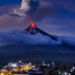
MAYON VOLCANO BULLETIN 03 February 2018 08:00 A.M.
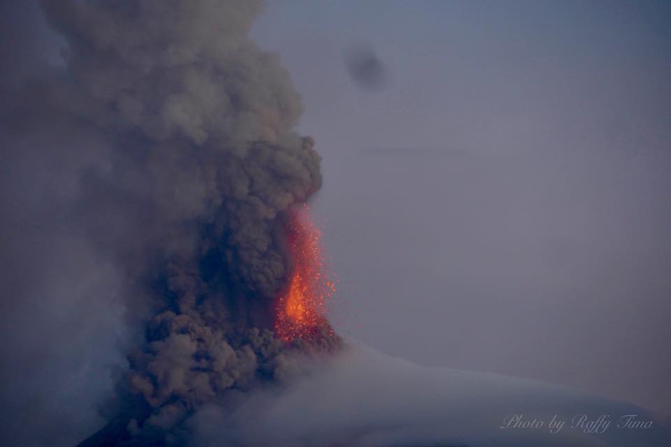
Sporadic and weak lava fountaining, lava flow and degassing from the summit crater characterized Mayon’s activity yesterday. Much of the activity produced low white to light-gray plumes, with the exception of one event that produced a 1000 meter-tall gray ash plume at 9:18 AM. Throughout the night, quiet lava effusion fed lava flows in the Miisi and Bonga-Buyuan channels and barrancos between these. The Miisi and Bonga-Buyuan lava flows have advanced to 3.2 kilometers and 4.3 kilometers, respectively, from the summit crater.
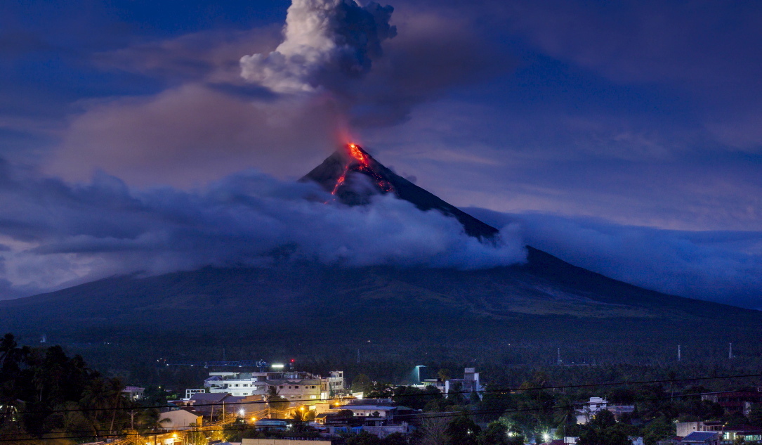
A total of seventeen (17) volcanic earthquakes, most of which corresponded to sporadic and weak fountaining events, ten (10) tremor events were recorded by Mayon’s seismic monitoring network. Sulfur dioxide gas emission was measured at an average of 1,583 tonnes/day on 02 February 2018. Electronic tilt and continuous GPS measurements indicate a sustained swelling or inflation of the edifice since November and October 2017, consistent with pressurization by magmatic intrusion.
Alert Level 4 remains in effect over Mayon Volcano. The public is strongly advised to be vigilant and desist from entering the eight (8) kilometer-radius danger zone, and to be additionally vigilant against pyroclastic density currents, lahars and sediment-laden stream flows along channels draining the edifice. Civil aviation authorities must also advise pilots to avoid flying close to the volcano’s summit as ash from any sudden eruption can be hazardous to aircraft. DOST-PHIVOLCS maintains close monitoring of Mayon Volcano and any new development will be communicated to all concerned stakeholders.
Source : Phivolcs
Photos : unknown , Raffy Tima .
Kilauea , Hawai :
19°25’16 » N 155°17’13 » W,
Summit Elevation 4091 ft (1247 m)
Current Volcano Alert Level: WATCH
Current Aviation Color Code: ORANGE
Activity Summary:
No significant change. Kīlauea continues to erupt at its summit and from the Puʻu ʻŌʻō vent on its East Rift Zone. The level of the summit lava lake this morning is about 33 m (110 ft) below the floor of Halemaʻumaʻu crater. The episode 61g lava flow is producing scattered surface flow activity at the base of the pali, and on the upper flow field. Lava is not entering the ocean at this time, and active flows currently pose no threat to nearby communities.
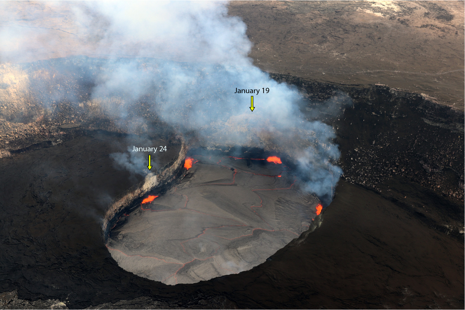
Today, with clear views at the summit of Kīlauea Volcano, four spattering sites were visible on the Halema‘uma‘u lava lake. Through the gas plume, a visible scar (light-colored wall rock) from the January 19 rockfall that triggered an explosive event, could be seen on the southern Overlook crater wall. Another, smaller scar on the northeastern lake wall (left), resulting from two tiny rock falls on January 24, was also visible.
Summit Observations:
Summit tiltmeters recorded continuing deflationary tilt before switching to inflation just before midnight. The level of the lava lake fell and rose in concert with the tilt, resulting little net change compared to yesterday morning. This morning, it was measured at about 33 m (110 ft) below the floor of Halemaʻumaʻu crater. Sulfur dioxide emission rates remain high. Seismicity is at normal levels, with tremor fluctuations related to the vigor of lava lake spattering.
Puʻu ʻŌʻō Observations:
Locally heavy rainfall caused sharp tilt excursion at the tiltmeter on Puʻu ʻŌʻō cone yesterday morning; since then there has not been much change in tilt. Weather obscured web cam views overnight. The sulfur dioxide emission rate from the East Rift Zone vents remains significantly lower than the summit emission rate.
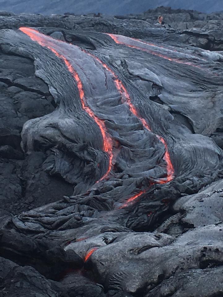
Lava Flow Observations:
The episode 61g flow is still active, but no lava is flowing into the ocean. Based on web cam views, surface lava flow activity continues on the upper portion of the flow field near Puʻu ʻŌʻō , on the pali, and in scattered areas below the pali on the back of the coastal plain. These lava flows pose no threat to nearby communities at this time.
Source : HVO.
Photos : HVO , David Ford . ( for Sean King) .
San Miguel ( Chaparrastique ) El Salvador :
Special Report No. 4
The activity of the Chaparrastic volcano tends to decrease.
Date and time of publication: 2018-02-02 13:00:00
The activity of the Chaparrastic volcano has shown a tendency to decrease. In the last 24 hours, the seismic vibration has varied between 63 and 114 RSAM units, with an average of 88.5 units (Figure 1), with a normal value between 50 and 150 RSAM units averaged over one hour.
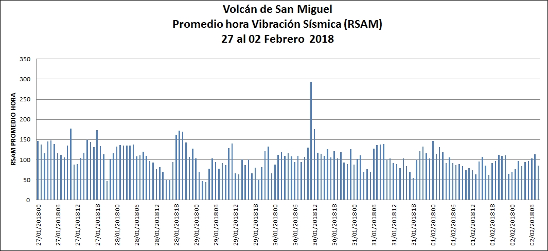
Figure 1. Seismic vibration of the volcano on its baseline
At 9:09 on February 2, the volcano is calm without the presence of a gas plume
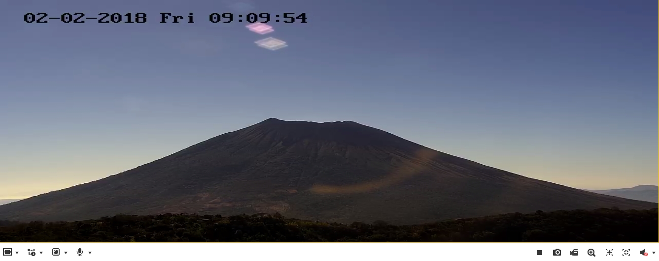
Figure 2. Current state of the volcano at 09:09 (02/02/2018).
The seismicity of the volcano showed a downward trend, being compatible with the decrease in the emission of gas. However, periodic changes in seismicity and degassing suggest the presence of fluids in the system, so it is not excluded that the future may show changes.
The MARN continues the systematic monitoring of the volcano and maintains close communication with the Directorate General of Civil Protection and local observers. In addition, he calls tourists and mountaineers to stay away from the upper part of the volcano because, often, there are sudden changes in activity.
Source : Snet
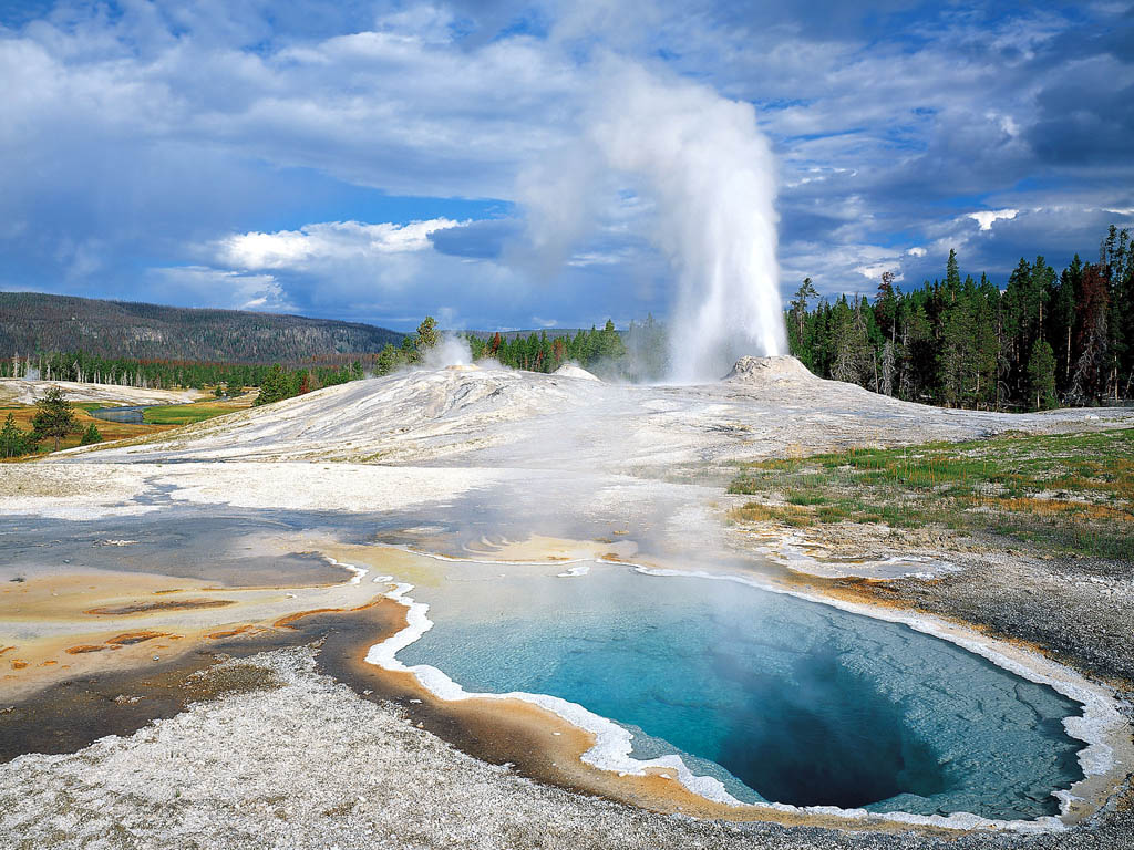
Yellowstone , United States :
44°25’48 » N 110°40’12 » W,
Summit Elevation 9203 ft (2805 m)
Current Volcano Alert Level: NORMAL
Current Aviation Color Code: GREEN
Recent work.
The LKWY seismic and GPS stations, located near Lake, WY, are back on line after a maintenance visit corrected an extended outage (since late November 2017) due to winter weather.
Be sure to check out Yellowstone Caldera Chronicles, the weekly article published by scientists of the Yellowstone Volcano Observatory (YVO). New articles describing Yellowstone’s geology, history, and recent activity are posted every Monday on the YVO website . Also, a public event featuring YVO scientists is being planned for May 7, 2018, in Gardiner, MT. Stay tuned for more information on this opportunity to interact directly with geologists, geophysicists, and geochemists who are studying how Yellowstone works.
Seismicity.
During January 2018, the University of Utah Seismograph Stations, responsible for the operation and analysis of the Yellowstone Seismic Network, reported that 108 earthquakes were located in the Yellowstone National Park region. The largest event was a small earthquake of magnitude 2.4 that occurred about nine miles northeast of Lake, WY, on January 9 at 08:00 AM MST.
January seismicity included a small earthquake swarm of 23 events ranging in magnitude from -0.5 to 0.8 during January 11–13 (MST) and located about 14 miles north-northeast of Old Faithful, WY.
Yellowstone earthquake activity in January was at low background levels.
Ground deformation.
By the start of January, the subsidence that began at Norris during December had stopped, and the area resumed uplifting. Subsidence of about 2 cm (0.8 in) was measured by the NRWY GPS station near the Norris Geyser Basin during the first 3 weeks of December. Since that time, the Norris area has been uplifting at is pre-December rate of a few mm/yr. GPS stations in the caldera continued to subside by a few mm/yr throughout December and January, seemingly unaffected by the change in deformation at Norris. The anomalous subsidence at Norris was not accompanied by significant earthquake activity and probably represents a temporary change in the storage conditions of hydrothermal fluids beneath the geyser basin.
The Yellowstone Volcano Observatory (YVO) provides long-term monitoring of volcanic and earthquake activity in the Yellowstone National Park region. Yellowstone is the site of the largest and most diverse collection of natural thermal features in the world and the first National Park. YVO is one of the five USGS Volcano Observatories that monitor volcanoes within the United States for science and public safety.
Source : YVO
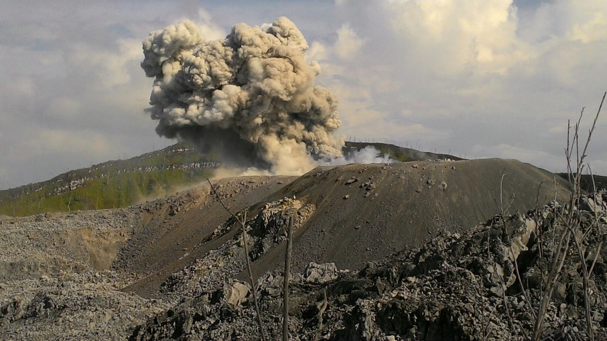
Ibu , Indonesia :
Level II Activity Level (WASPADA). G. Ibu (1340 m above sea level) has been erupting since 2008.
Since yesterday until this morning visually emissions from the crater can be observed clearly until they are covered with fog. The eruption of smoke and ash is observed with a height of 300 to 600 meters above the summit of the peak, low to medium pressure, white to gray color and low to moderate intensity. The wind is blowing slowly from west to south.
On January 30, 2018, records of seismographs noted:
45 earthquakes of eruption.
32 earthquakes of emission.
5 events of type Harmonic Tremor.
Recommendation: Communities around G. Ibu and visitors / tourists must not have activity, climb, and get closer within 2 km, with expansion in the eastern sector 3.5 km from the northern openings of the active crater of G. Ibu.
Vona: The last registered color code ORANGE, was published on August 28, 2017 at 6:12 CET, related to the eruption with an ash altitude at 1725 m above sea level or 400 m above sea level. above the top, the ash columns bowing to the north.
Source : VSI


No comment yet, add your voice below!