18 Janvier 2018.
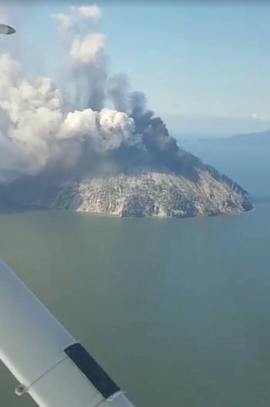
Kadovar , Papouasie Nouvelle Guinée :
Les rapports actuels publiés aujourd’hui par l’Observatoire Volcanique de Rabaul PNG et par le Département d’études minérales et de la gestion des géorisques pour le volcan Kadovar indiquent qu’il est toujours en éruption.
Le cratère principal produit des nuages de cendres gris faibles à modérés , s’élevant à 300 mètres au-dessus de l’évent, avec de longs intervalles et une activité explosive soutenue produisant des nuages de cendres à 500 à 800 mètres au-dessus du sommet qui s’inclinent vers le Sud et le Sud-Ouest en direction de la Sepik River .
Tandis qu’une équipe de l’Observatoire de Rabaul installait un sismomètre sur Kadovar, ils ont assisté à un événement de type Vulcanien modéré avec des projections de roches incandescentes . Les évents du Sud-Ouest et de l’Ouest produisent des émissions faibles mais sont souvent masqués par les cendres du cratère principal.
Un panache modéré continu de vapeur blanche est en train de s’élever de l’évent côtier du Sud – Est à 800 mètres au-dessus de l’île. L’évent côtier du Sud-Est émet une lueur rouge continue la nuit avec quelques périodes d’intensité lumineuse fluctuante.
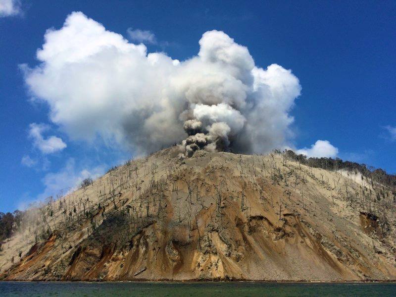
Les zones d’évents arrière sont affectées par la brume légère. Des explosions discrètes , vulcaniennes , ajoutent des impulsions chargées de cendres plus élevées . Les sismomètres fonctionnent maintenant depuis 11h00 (heure locale) sur Blup Blup et 15h00 (heure locale) depuis mardi sur Kadovar. Entre 11 heures hier et 8 heures ce matin, le sismomètre de Blup Blup a enregistré 6 tremblements de terre discrets à haute fréquence et, pour les séismes sur Kadovar, les évènements présentent des intervalles de 2 secondes et sont situés entre 14 et 15 km de profondeur. Le volcan est maintenant surveillé sismiquement en temps quasi réel, si la situation s’intensifie, le nombre de tremblements de terre devrait augmenter en nombre et en intensité.
La situation est également surveillée par diverses techniques satellitaires. L’enregistrement des tremblements de terre à haute fréquence sur Kadovar indique des «événements de type rupture de roche» et indique que la structure est encore stressée et que la situation est dynamique.
Le niveau de risque pour l’instant sur l’île est ÉLEVÉ. Sur le continent et les autres îles voisines, il y a un petit risque de TSUNAMIS toujours présent .
Source : news.pngfacts.com.
Photo : us4.campaign.
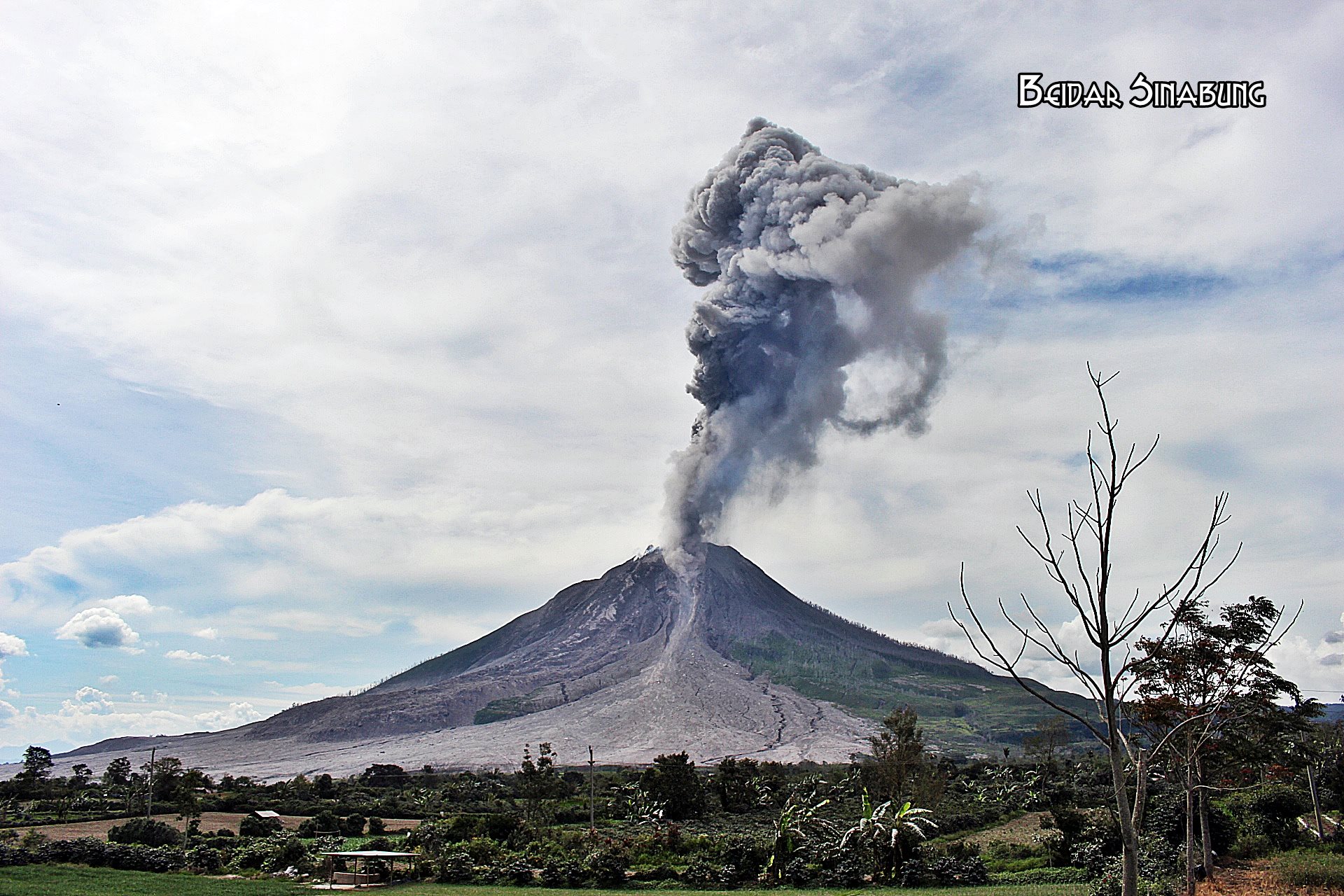
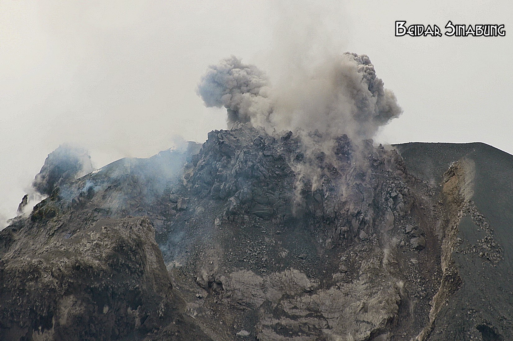
Mayon , Philippines :
BULLETIN D’ ACTIVITE DU VOLCAN MAYON, 18 janvier 2018 , 8:00 A.M.
Uns effusion de lave depuis le nouveau dôme de lave du sommet et des effondrements de lave ont caractérisé l’activité éruptive du volcan Mayon au cours des dernières 24 heures. Quarante-huit (48) éboulements, deux (2) flux pyroclastique ou PDC et un (1) séisme volcanique ont été enregistrés par le réseau de surveillance sismique du Mayon. Les événements de chutes de pierres ont été générés par l’effondrement du front et des bords des coulées de lave qui avancent dans le ravin Miisi et par la chute de parties du dôme sommital dans les ravins Matanag et Buyuan. Actuellement, la coulée de lave dans le ravin Miisi s’est avancée sur environ trois (3) kilomètres depuis le cratère sommital tandis que les flux pyroclastique se sont mis en place à peu près dans les mêmes zones de drainage, bien à l’intérieur de la zone de danger permanent. Des nuages de cendres ont été émis à partir des événements de chutes de pierres et des flux pyroclastiques ainsi que de la désintégration persistante de la lave sur le front avançant de la coulée de lave Miisi avant de dériver vers le Sud-Ouest. Les émissions de dioxyde de soufre ont été mesurées à une moyenne de 1159 tonnes / jour le 17 janvier 2018.
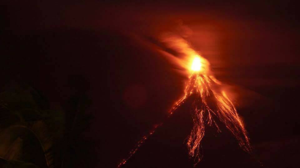
Le niveau d’alerte 3 reste en vigueur sur le volcan Mayon, ce qui signifie qu’il se trouve actuellement dans un niveau d’agitation relativement élevé car le magma se trouve dans le cratère et une éruption dangereuse est possible dans les semaines ou même les jours. Il est fortement recommandé au public d’être vigilant et de ne pas pénétrer dans la zone de danger permanent de six (6) kilomètres et la zone de danger prolongée de 7 kilomètres sur les flancs Sud en raison du risque de chutes de pierres, de glissements de terrain , d’ explosions soudaines ou d’ effondrement du dôme pouvant générer des flux volcaniques dangereux. Une vigilance accrue contre les courants de densité pyroclastiques, les lahars et les écoulements chargés de sédiments le long des canaux drainant l’édifice est également conseillée. Les autorités de l’aviation civile doivent également conseiller aux pilotes d’éviter de voler à proximité du sommet du volcan car les cendres provenant de toute éruption soudaine peuvent être dangereuses pour les aéronefs. Selon la configuration des vents saisonniers, les chutes de cendres peuvent très probablement se produire du côté Sud-Ouest du volcan.
Le DOST-PHIVOLCS maintient une surveillance étroite du volcan Mayon et tout nouveau développement sera communiqué à toutes les parties prenantes concernées.
Source : Phivolcs.
Photo : Rodrigo Contreras Lopez
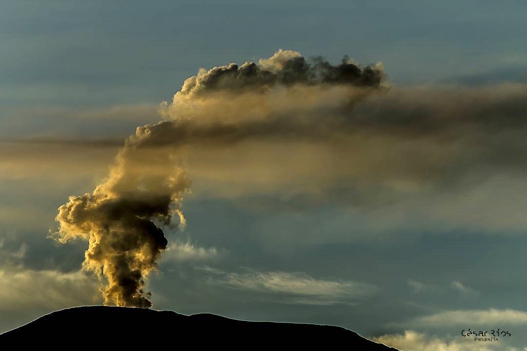
Nevado del Ruiz , Colombie :
Sujet: Bulletin d’activité du volcan Nevado del Ruiz.
Le niveau d’activité se poursuit au niveau : Niveau d’activité jaune ou (III): changements dans le comportement de l’activité volcanique.
En ce qui concerne le suivi de l’activité du volcan Nevado del Ruiz, le SERVICE GÉOLOGIQUE COLOMBIEN informe que:
Au cours de la dernière semaine, les différents paramètres de surveillance montrent que le volcan Nevado del Ruiz continue d’afficher un comportement instable.
La sismicité provoquée par la fracturation des roches qui composent le volcan a montré une diminution du nombre de séismes et de l’énergie sismique libérée par rapport à la semaine précédente. Les séismes se situaient principalement dans les secteurs Nord distal, Sud-Ouest , Sud-Est, Nod-Est et dans le cratère Arenas. Les profondeurs des séismes variaient entre 0,7 et 7,2 km. La magnitude maximale enregistrée au cours de la semaine était de 1,6 ML (Magnitude locale), correspondant au séisme enregistré le 9 janvier à 22h09 (heure locale), situé au Sud-Ouest du cratère Arenas, à une profondeur de 3,8 km.
L’activité sismique associée à la dynamique des fluides à l’intérieur des canaux de la structure volcanique a montré une augmentation du nombre de séismes enregistrés et de l’énergie sismique libérée, par rapport à la semaine précédente. Ce type d’activité se caractérise principalement par la survenue de tremblements de terre de fluides multiples, de type longues périodes et de très longues périodes, ainsi que par des impulsions de tremor. Les tremblements de terre ont été localisés principalement dans le voisinage du cratère Arenas et dans les secteurs Sud-Est et sSud du volcan.
La déformation volcanique mesurée à partir des inclinomètres électroniques, des stations GNSS (Global Navigation Satellite System) et des images radar, montre un comportement de stabilité sans enregistrer d’importants processus de déformation de la structure volcanique.
Le volcan continue d’émettre de la vapeur d’eau et des gaz dans l’atmosphère, parmi lesquels le dioxyde de soufre (SO2) se distingue, comme en témoignent les valeurs obtenues par les stations SCANDOAS installées sur le volcan et l’analyse des images satellites. Dans le suivi des informations fournies par les portails MIROVA et NASA FIRMS, plusieurs anomalies thermiques ont été enregistrées au voisinage du cratère Arenas.
La colonne de gaz et de vapeur atteignait une hauteur maximale de 1300 m mesurée au sommet du volcan, le 11 janvier. La direction de dispersion de la colonne était régie par la direction du vent dans la zone, qui dominait pendant la semaine vers le Nord-Ouest, le Sud-Ouest et le Sud-Est par rapport au cratère Arenas.
Le volcan Nevado del Ruiz continue au niveau d’activité jaune.
Source : SGC
Photo : Cesar Rios
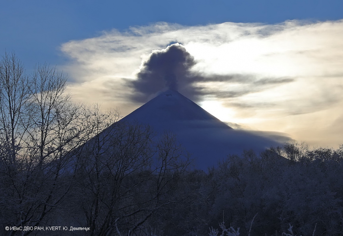
Klyuchevskoy , Kamchatka :
AVIS D’OBSERVATION DU VOLCAN POUR L’AVIATION (VONA).
Délivré: 18 Janvier 2018.
Volcan: Klyuchevskoy (CAVW # 300260)
Code couleur actuel de l’aviation: ORANGE
Code couleur de l’aviation précédent: orange
Source: KVERT
Numéro de l’avis: 2018-20
Localisation du volcan : N 56 deg 3 min E 160 deg 38 min
Région: Kamtchatka, Russie
Altitude du sommet: 15580 pieds (4750 m)
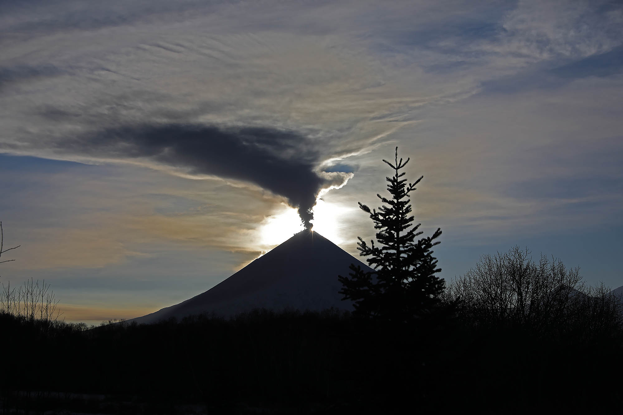
Résumé de l’activité volcanique:
L’ activité éruptive modérée du volcan persiste. Un panache de gaz-vapeur contenant une certaine quantité de cendres a dérivé sur environ 45 km vers l’Est du volcan.
Une activité éruptive modérée du volcan continue. L’activité en cours pourrait affecter les aéronefs volant à basse altitude.
Hauteur des nuages volcaniques:
1650 m (5 000 m) AMSL Temps et méthode de détermination du panache de cendres et de la hauteur des nuages: 20180118 / 0500Z – Données vidéo
Autres informations sur les nuages volcaniques:
Distance du panache de cendres / nuage du volcan: 28 mi (45 km)
Sens de dérive du panache de cendres / nuage du volcan: E / azimut 91 deg
Temps et méthode de détermination du panache de cendres / nuage: 20180118 / 0440Z – Himawari-8
Source : Kvert.
Photo : Volkstat ru , Yu Demyanchuck.
Popocatépetl , Mexique :
17 janvier, 11h00 (17 janvier, 17h00 GMT).
Au cours des dernières 24 heures, grâce aux relevés sismiques du système de surveillance du volcan Popocatépetl, 110 exhalaisons de faible intensité ont été identifiées, accompagnées de vapeur d’eau, de gaz et parfois de très légères quantités de cendres.
D’autre part, 26 minutes de tremor harmonique et 16 séismes volcano-tectoniques avec des amplitudes comprises entre M 1,2 et M2,2 ont été enregistrés.
Pendant la nuit, aucune incandescence n’a été observée sur le cratère.

A partir de ce matin et jusqu’au moment de ce rapport le volcan est observé sans émissions.
Les autres paramètres de surveillance restent inchangés.
Le CENAPRED demande instamment de ne pas approcher le volcan et surtout le cratère, en raison du danger de chute de fragments balistiques, et en cas de fortes pluies, de s’éloigner du fond des ravins en raison du risque de glissements de terrain et de coulées de boue.
Le feu de signalisation d’alerte volcanique du Popocatepetl est situé à Amarillo Phase 2.
Source : Cenapred
Photo : Archive ( 02/2016)