January 18 , 2023 .
Italy , Stromboli :
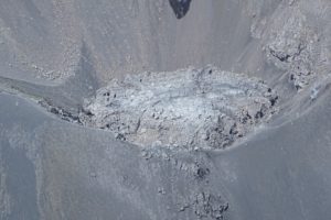
Statement on Stromboli activity, January 17, 2023, 11:20 (10:20 UTC).
The National Institute of Geophysics and Volcanology, Etna Observatory, communicates that from 09:51 UTC, surveillance cameras observed an overflow of lava from the northern area of the crater. The lava flow front is located in the upper part of the Sciara del Fuoco. The phenomenon is still ongoing.
From a seismic point of view, from about 09:31 UTC, a moderate increase in the average amplitude of the volcanic tremor was observed, in the band of average values. There are no significant variations in the occurrence rate and amplitude of explosive earthquakes.
The signals from the GNSS stations and clinometers do not show any significant variations.
Further updates will be communicated soon.
WEEKLY BULLETIN, from January 09, 2023 to January 15, 2023, (issue date January 17, 2023)
ACTIVITY STATUS SUMMARY
In the light of the monitoring data, it is highlighted:
1) VOLCANOLOGICAL OBSERVATIONS: Normal Strombolian activity with intense spatter activity from the North Crater area. The total hourly frequency fluctuated between medium-low (7 events/h) and medium (11 events/h) values. The intensity of the explosions was mainly medium and low in the North crater area and medium and high in the South Center crater area.
2) SEISMOLOGY: The seismological parameters do not show significant variations.
3) SOIL DEFORMATIONS: The island’s soil deformation monitoring networks did not show any significant variation to report for the period considered.
4) GEOCHEMISTRY: The flow of SO2 at an average level
CO2 fluxes in the crater area show a downward trend while remaining on medium-high values.
CO2/SO2 ratio: there are no updates; the latest data indicated mean values equal to 10.1.
Isotope ratio of helium in groundwater: decreasing but still on medium to high values (4.32).
5) SATELLITE OBSERVATIONS: The thermal activity observed from the satellite was generally weak.

VOLCANOLOGICAL OBSERVATIONS
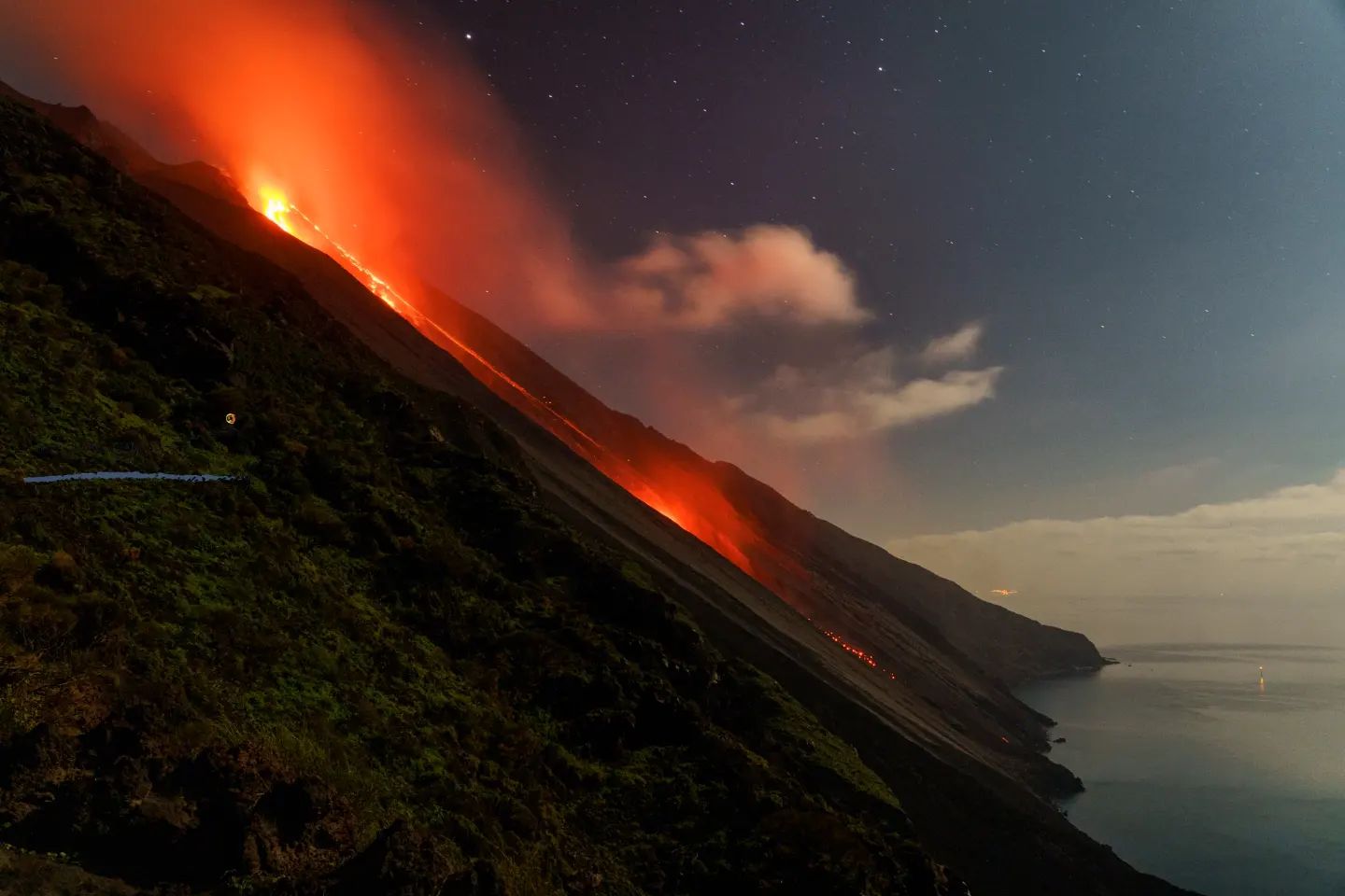
During the observation period, the eruptive activity of Stromboli was characterized by the analysis of the images recorded by the surveillance cameras INGV-OE at 190 m (SCT-SCV), Punta dei Corvi and Pizzo, while the 400m camera is currently unavailable due to video signal acquisition issues caused by damage to the fiber optic connection between Punta Labronzo and AOC due to severe weather that hit the island on August 12, 2022. The explosive activity was produced, mainly, from 4 (four) eruptive vents located in the North (N) crater zone and one located in the Center-South (CS) zone. The vents of the North crater zone are located in the upper part of the Sciara del Fuoco while the mouth of the Center-South crater zone is located inside the crater terrace. In detail, in the northern area of the crater, a vent is located near sector N1 and three located near sector N2.
Due to the unfavorable weather conditions of January 10 and 12, 2023, the visibility of the active areas of Stromboli was not sufficient for a correct description of the eruptive activity.

Observations of explosive activity captured by surveillance cameras
In the northern area of the crater (N), explosive activity was only observed from the vents located inside the Sciara del Fuoco, in its upper part, after the collapse of the northern edge. The four vents showed explosive activity (explosions of varying intensity from weak (less than 80 m in height) to strong (more than 150 m in height) emitting coarse materials (bombs and lapilli)). In addition, intense projection activity was observed on January 11 and 13, 2023 from the vent located near sector N1.
The average frequency of explosions varied from 2 to 6 events/h.
In the Center-South (CS) zone, explosive activity of medium and high intensity was observed (sometimes the products exceeded 250 in height) emitting fine materials (ash) mixed with coarse materials. The frequency varied between 2 and 5 events/h.
Source : INGV.
Photos : stromboli stati d’animo , , stromboli pictures , INGV.
Italy / Sicily , Etna :
WEEKLY BULLETIN, from January 09, 2023 to January 15, 2023, (issue date January 17, 2023)
ACTIVITY STATUS SUMMARY
In the light of the monitoring data, it is highlighted:
1) VOLCANOLOGICAL OBSERVATIONS: Effusive activity with lava flows in the Vallée del Leone, degassing at variable speed from the summit craters.
2) SEISMOLOGY: Low seismic activity due to fracturing; average amplitude of the volcanic tremor on a medium or low-medium level.
3) INFRASOUND: Low activity related to infrasonic events.
4) GROUND DEFORMATIONS: During the last week, the ground deformation monitoring networks have not recorded any significant variations.
5) GEOCHEMISTRY: SO2 flux at a moderately medium-low level The soil CO2 flux values recorded last week are average values.
The CO2 of the water table (EtnaAcque Network) presents variations which are part of the seasonal variability of the site.
Helium data from the latest sampling shows no significant changes from the previous ones, settling on the high level.
6) SATELLITE OBSERVATIONS: The thermal activity observed by satellite in the summit zone was of a high level in correspondence with the effusive eruption in the summit zone.
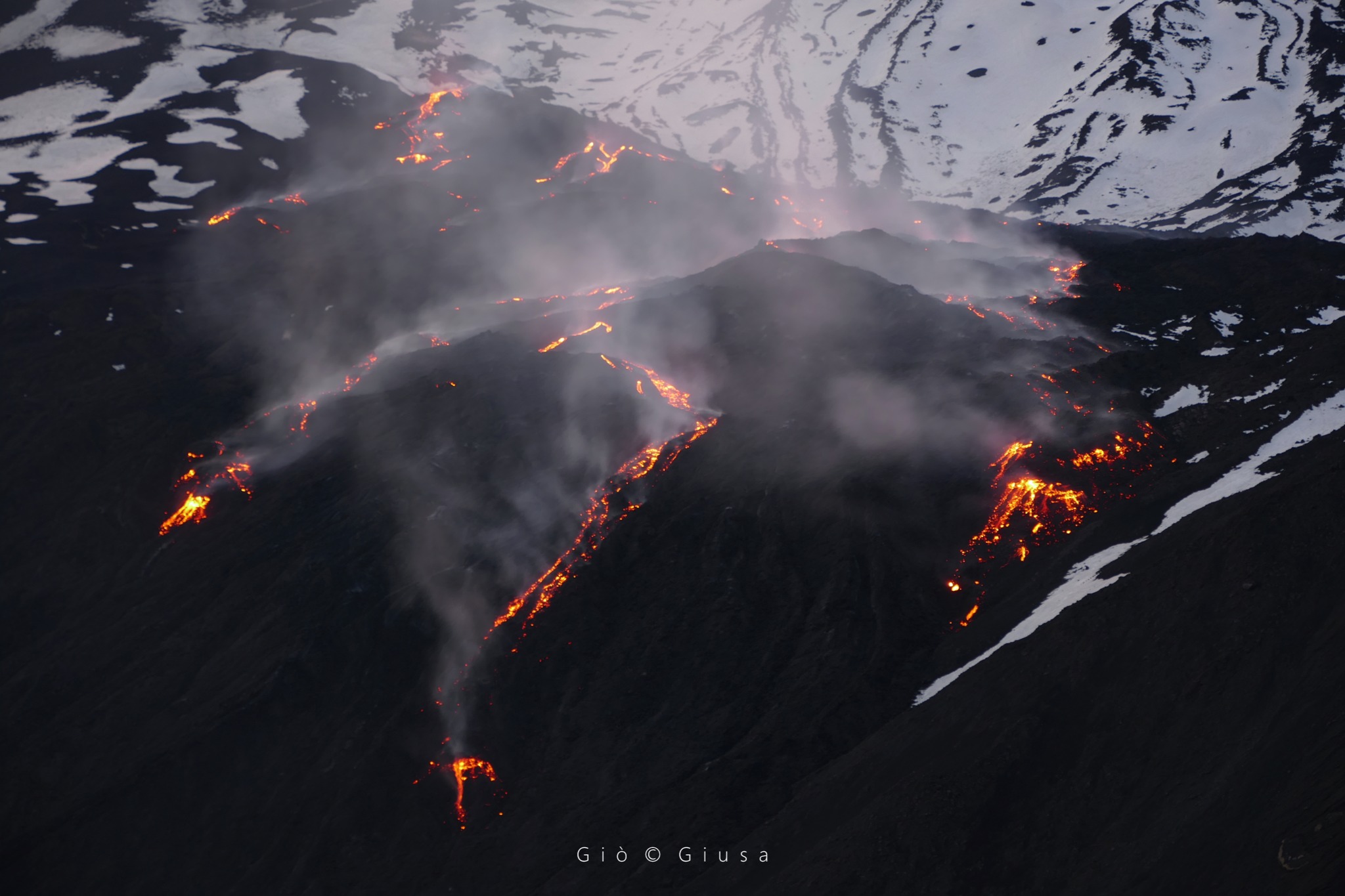
During the period studied, the effusive activity that began on November 27, 2022 from the active effusive vent at the northeast base of the Southeast crater continued, at an altitude of approximately 2800 m . Compared to previous weeks, no significant changes were observed from the cameras, effusive activity continued to show variable feeding, resulting in new lava flows that overlaid previous ones. In general, the morphology of the lava field, observable by surveillance cameras, remained unchanged and the lava flows continued to expand in the Valle del Leone and in the upper Valle del Bove, with the most advanced fronts confined to an altitude between about 2400 -2200 m altitude and, in particular, at an altitude of 2250 m i January 14 .

Map of the lava field updated to January 14, 2023, made by analyzing Sentinel satellite imagery from January 14. The background image is the shaded model of the relief of the summit area of Etna, obtained by processing drone images acquired during several overflights (September 15 and 21, 2022, October 6, 21 and 23), superimposed on the shaded model derived from Pléiades images of August 22, 2020 (AO Remote Sensing). CSE = Southeast Crater
The area covered from November 27, 2022 to January 14, 2023 is equal to 7 x 10^5 m2 and the total volume is between 3.5 and 4.5 x 10^6 m3. This estimate is preliminary and an error of approximately 40% is estimated.
During the week of observation, the summit craters were characterized by a variable rate degassing, mainly to the detriment of the Bocca Nuova crater which continued to feed a continuous, sometimes pulsating degassing. The Southeast crater produced localized fumarolic degassing along the rim of the crater. Slight fumarolic degassing from the Northeast crater and very modest fumarolic degassing from the Voragine crater.
Source : INGV.
Photos : Gio Giusa , INGV.
Indonesia , Ili Lewotolok :
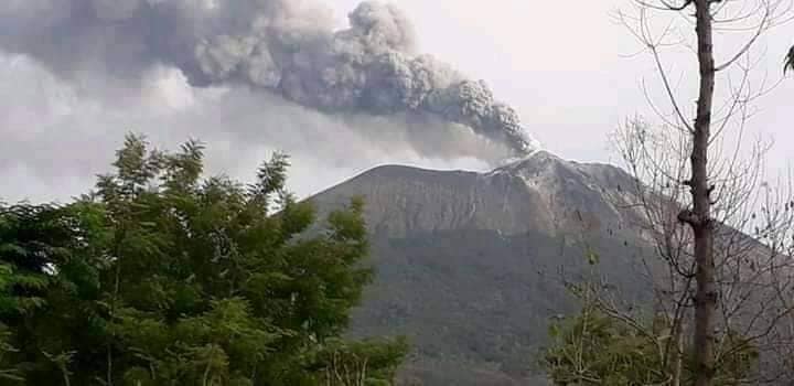
An eruption of G. Ili Lewotolok occurred on Tuesday, January 17, 2023, at 9:52 p.m. WITA. The height of the eruptive column was observed at ± 500 m above the summit (± 1923 m above sea level). The ash column was observed to be white to gray with a thick intensity, oriented towards the southwest. The eruption was recorded on a seismograph with a maximum amplitude of 2.6 mm and a duration of 33 seconds.
VOLCANO OBSERVATORY NOTICE FOR AVIATION – VONA
Issued : January 17 , 2023
Volcano : Ili Lewotolok (264230)
Current Aviation Colour Code : ORANGE
Previous Aviation Colour Code : orange
Source : Ili Lewotolok Volcano Observatory
Notice Number : 2023LEW003
Volcano Location : S 08 deg 16 min 19 sec E 123 deg 30 min 18 sec
Area : East Nusa Tenggara, Indonesia
Summit Elevation : 4554 FT (1423 M)
Volcanic Activity Summary :
Eruption with volcanic ash cloud at 13h52 UTC (21h52 local).
Volcanic Cloud Height :
Best estimate of ash-cloud top is around 6154 FT (1923 M) above sea level or 1600 FT (500 M) above summit. May be higher than what can be observed clearly. Source of height data: ground observer.
Other Volcanic Cloud Information :
Ash cloud moving to southwest. Volcanic ash is observed to be white to gray. The intensity of volcanic ash is observed to be thick.
Remarks :
Eruption recorded on seismogram with maximum amplitude 2.6 mm and maximum duration 33 second.
Source : Magma Indonésie .
Photo : Kodi Setiawan ( archive)
Chile , Laguna del Maule :
Special Report on Volcanic Activity (REAV), Maule region, Laguna del Maule volcanic complex, January 18, 2023, 02:30 a.m. local time (mainland Chile)
The National Geology and Mining Service of Chile (Sernageomin) announces the following PRELIMINARY information, obtained through the monitoring equipment of the National Volcanic Monitoring Network (RNVV), processed and analyzed at the Volcanological Observatory of the Andes del Sud ( Ovdas):
On Wednesday January 18 at 02:07 local time (05:07 UTC), monitoring stations installed near the Laguna del Maule volcanic complex recorded an earthquake associated with both rock fracturing and fluid dynamics inside the volcanic system (hybrid type).
The characteristics of the earthquake after its analysis are as follows:
Origin time: 02:07 Local time (05:07 UTC)
Latitude: 36.166 ° S
LENGTH: 70.440° E
DEPTH: 6.4 km
Local magnitude: 3.1 (ml)
Reduced display: 306 (cm*cm)
The volcanic technical alert remains at the green level.
Source : Sernageomin.
Photo : Segemar.
Hawaii , Kilauea :
Tuesday, January 17, 2023, 9:22 AM HST (Tuesday, January 17, 2023, 19:22 UTC)
19°25’16 » N 155°17’13 » W,
Summit Elevation 4091 ft (1247 m)
Current Volcano Alert Level: WATCH
Current Aviation Color Code: ORANGE
Activity Summary:
The summit eruption of Kīlauea Volcano, within Halemaʻumaʻu crater, continued over the past 24 hours. All recent eruptive activity has been confined to the crater. No significant changes have been observed at the summit or in either rift zone.
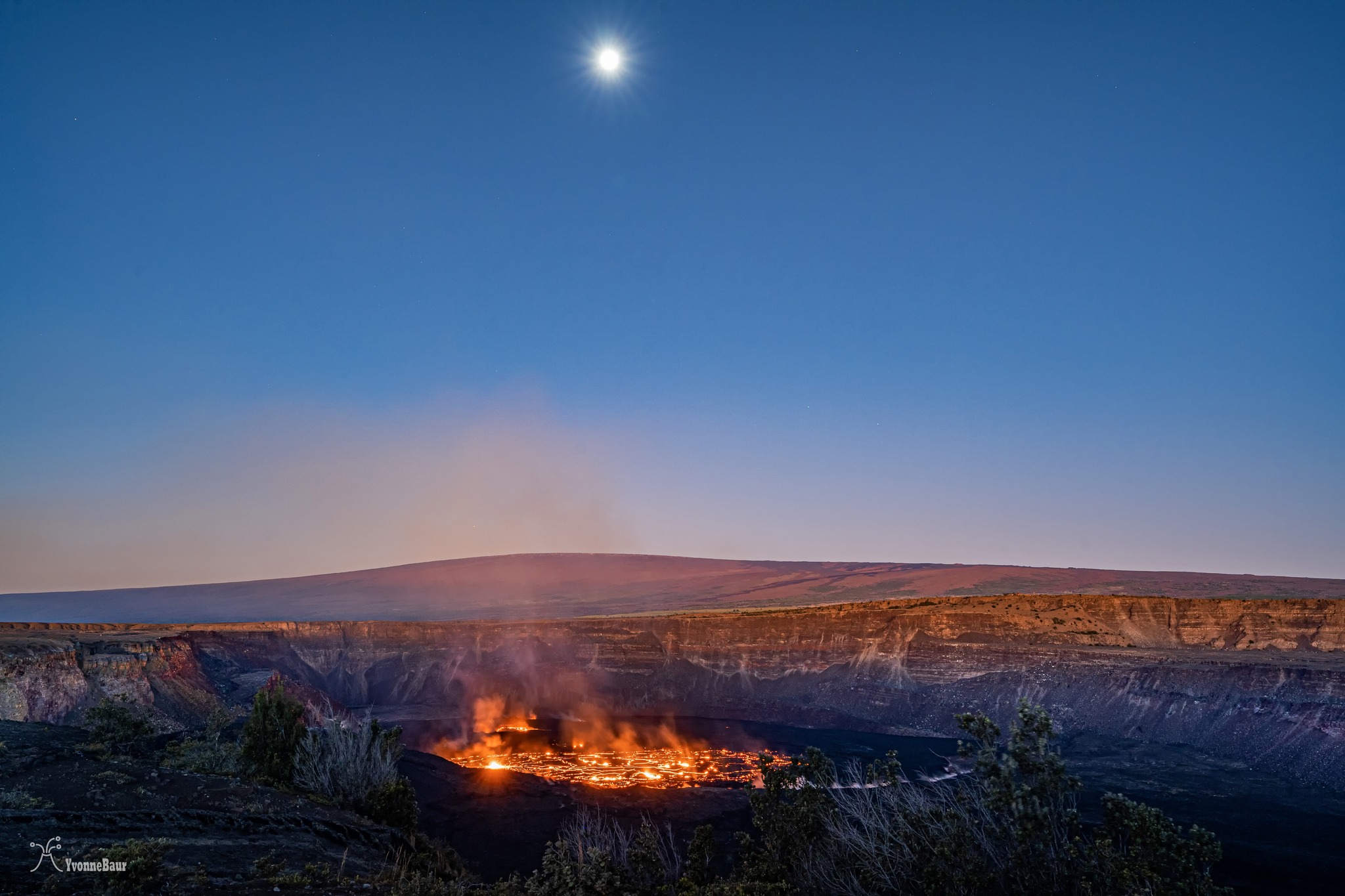
Halemaʻumaʻu Lava Lake Observations:
Eruption of lava in the eastern portion of Halemaʻumaʻu crater floor continued over the past 24 hours. Activity is concentrated in a large lava lake in the eastern half of the crater, as well as a smaller area of lava within the basin in the western half of the crater that was the focus of activity in 2021–2022. The active lava lake in the eastern half of the crater has one dominant fountain, measured at 6-7 yards (meters) high. The eastern lava lake had an area of approximately 30 acres (12 hectares) on January 10, and the surface area has fluctuated slightly over the past 24 hours with several small overflows from the perched lake.
Summit Observations:
Summit tiltmeters showed deflationary tilt over most of the past day, with the onset of inflationary tilt this morning. Volcanic tremor remains above background levels. A sulfur dioxide (SO2) emission rate of approximately 3,500 tonnes per day (t/d) was measured on January 9, 2023.
Rift Zone Observations:
No unusual activity has been noted along the East Rift Zone or Southwest Rift Zone; low rates of ground deformation and seismicity continue along both. Measurements from continuous gas monitoring stations downwind of Puʻuʻōʻō in the middle East Rift Zone have been below detection limits for SO2, indicating that SO2 emissions from Puʻuʻōʻō are negligible.
Source : HVO.
Photo : Yvonne Baur.