April 11 , 2018.
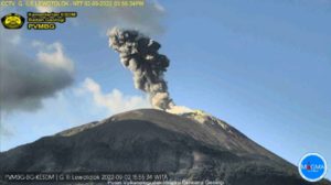
Chiles / Cerro Negro , Colombia :
Subject: Activity bulletin of Chiles and Cerro Negro volcanoes
The level of activity of volcanoes is maintained at the level:
YELLOW LEVEL ■ (III): CHANGES IN THE CONDUCT OF VOLCANIC ACTIVITY
Following the activity of VOLCANS CHILES and CERRO NEGRO, the COLOMBIAN GEOLOGICAL SERVICE (SGC) reports that:
In the previous week, seismicity in the Chiles – Cerro Noire volcano region showed a decrease in both the appearance and energy of recorded events, which mostly continue to be associated with fracturing processes of rocks. As of April 4, the daily average is about 360 earthquakes and a maximum magnitude of M2.4 on the Richter scale. During this period, there was no report of earthquakes felt.
It is pointed out that occasional records of earthquakes that are related to the movements of fluids within the volcanic system continue, without the presence of surface manifestations so far.
The COLOMBIAN GEOLOGICAL SERVICE and the GEOPHYSICAL INSTITUTE OF THE NATIONAL POLICY SCHOOL OF ECUADOR closely monitor the evolution of this seismic activity and the volcanic phenomenon and will inform timely changes detected.
Source : SGC
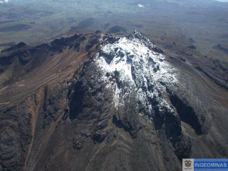
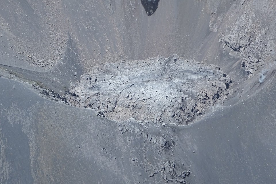
Nevados de Chillan , Chile :
Volcanic Activity Report (VAR), Volcanological Observatory of the Southern Andes – Ovdas
Date: April 10, 2018 4:30 pm HL, April 10 (3:00 pm)
Current alert level: ORANGE
1. Volcanic monitoring
1.1 Seismic activity:
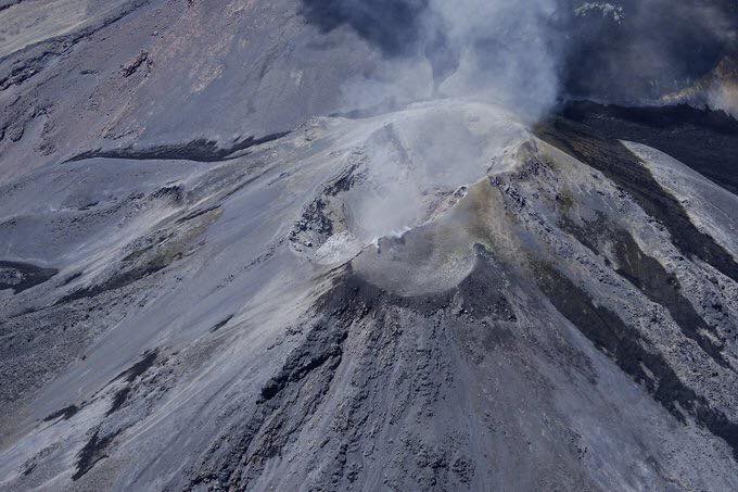
The activity of the Nevados de Chillan volcanic complex, in the last 24 hours, has a level of activity similar to that of previous days, with a slight decrease in the occurrence of volcanic earthquakes, while the energy released showed a low increase. In addition, long-period seismicity (LP) maintains a temporal relationship with the recording of explosions, from which the one that occurred 1 to 3h31, which showed a reduced displacement value of 641 cm2. Seismicity of LP type and tremor type has a moderate / high value for this volcanic system with no volcano-tectonic seismicity.
1.2 Surface activity
Maximum height of the column (km): not detected.
Direction: not detected.
Main distance Panache (km): not detected.
Source of information: OVDAS IP camera
Incandescence (yes / no): Yes
Observations:
Due to the prevailing weather conditions in the area, it was not possible to establish column heights for surface volcanic activity. During the night, it was possible to partially visualize the incandescence associated with the appearance of certain explosions.
1.3 Other observations
⦁ During the period, infrasonic sensors recorded acoustic signals due to explosions with amplitudes up to 3.5 Pa reduced to 1 km.
⦁ Thermal radiation information processed by the MIROVA group did not report thermal anomalies for the volcano.
The area of potential danger is determined on the basis of a moderate to high explosive eruptive phase, associated with a partial destruction of the lava dome nestled in the active crater. The procedure planned before this event would be the generation of a 10-kilometer high eruptive column that collapses, which could generate pyroclastic surges that would radially affect the crater.
Eventually, depending on the availability of sediments and water, flooding could occur in the large valleys draining the Las Termas sub-complex, mainly towards Estero Renegado, Shangri-La Valley, the Rio’s headwaters. Nuble. In addition, the gravitational collapse of the lava dome of the Northeast crater is envisaged, which could affect the Gato and Las Minas rivers through pyroclastic flows, ash and blocks.
Finally, the most likely scenario is the sporadic generation of minor eruptive impulses (columns no greater than 5 km altitude) associated with explosions of gas, pyroclastic particles whose ballistic projections fluctuate over a distance of 2 to 3 km around the active crater.
Source : Sernageomin.
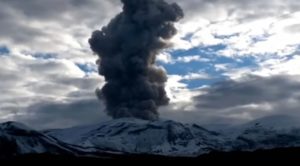
Agung , Indonesia :
VOLCANO OBSERVATORY NOTICE FOR AVIATION – VONA.
Issued: April 04 , 2018.
Volcano: Agung (264020)
Current Aviation Colour Code: ORANGE
Previous Aviation Colour Code: orange
Source: Agung Volcano Observatory
Notice Number: 2018AGU21
Volcano Location: S 08 deg 20 min 31 sec E 115 deg 30 min 29 sec
Area: Bali, Indonesia
Summit Elevation: 10054 FT (3142 M)
Volcanic Activity Summary:
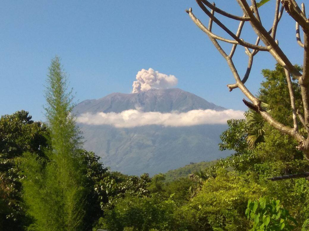
Eruption with volcanic ash cloud at 02:04 UTC (09:04 Local)
Volcanic Cloud Height:
Best estimate of ash-cloud top is around 11654 FT (3642 M) above sea level, may be higher than what can be observed clearly. Source of height data: ground observer.
Other Volcanic Cloud Information:
Ash-cloud is moving south west
Remarks:
seismic activity is dominated by volcanic earthquake
Source : Magma Indonésie.
Photo : Via B Duick.
Popocatepetl , Mexico :
April 10, 10:30 am (April 10, 15:30 GMT)
In the last 24 hours, according to the monitoring systems of the Popocatepetl volcano, 209 low intensity exhalations accompanied by water vapor and gas have been identified.
The succession of exhalations and tremors that began today (10/04) at 05:23 pm ended at 8:19 pm with a total duration of 176 minutes. The height of the column that was generated averaged 1 km above the average crater level, which winds dispersed to the east-southeast. The emission of incandescent fragments reached a distance of 500 m from the crater and was observed. This type of activity is considered in the yellow phase 2 volcanic warning light.
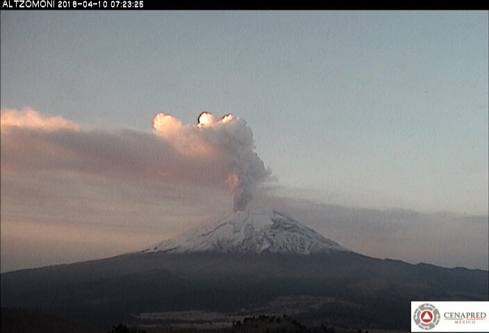
During the night, an incandescence was observed on the crater.
At the time of this report, there is a constant emission of volcanic gas directed towards the East-South-East.
CENAPRED asked not to approach the volcano and in particular the crater, the risk of falling projectile fragments (Figure 5) and in case of heavy rain far from the bottoms by the danger of landslides and mudslides.
The volcanic warning light of the Popocatepetl volcano is located at Amarillo Phase 2.
Source : Cenapred