April 28 , 2021 .
Italy / Sicily , Etna :
Weekly bulletin from April 19, 2021 to April 25, 2021 (publication date April 27, 2021)
SUMMARY OF THE STATE OF ACTIVITY
In the light of surveillance data, it is highlighted:
1) VOLCANOLOGICAL OBSERVATIONS: Degassing activity of summit craters; a single explosion at the Southeast Crater
2) SEISMOLOGY: absence of seismic fracturing activity with Ml> = 2.0; amplitude of the tremor between the low and medium-low values.
3) INFRASON: moderate infrasound activity.
4) DEFORMATIONS: There are no significant variations in the time series of soil deformation monitoring networks.
5) GEOCHEMISTRY: The flow of SO2 at an average level The flow of CO2 from the soil is maintained at medium-low values.
The partial pressure of dissolved CO2 in groundwater is at low values.
No new data from the C / S ratio is available.
Helium isotopic ratio values, while remaining at high levels, show a slight decrease in the last sample of 04/01/2021.
6) SATELLITE OBSERVATIONS: The thermal activity in the summit area is at a low level.
VOLCANOLOGICAL OBSERVATIONS
During the week, the monitoring of the volcanic activity at the level of the summit craters of Etna was carried out by analyzing the images of the network of surveillance cameras of the section INGV Catania, Osservatorio Etneo (INGV-OE). Observations were often made difficult by adverse weather conditions.
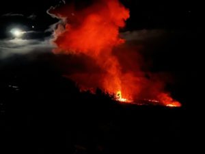
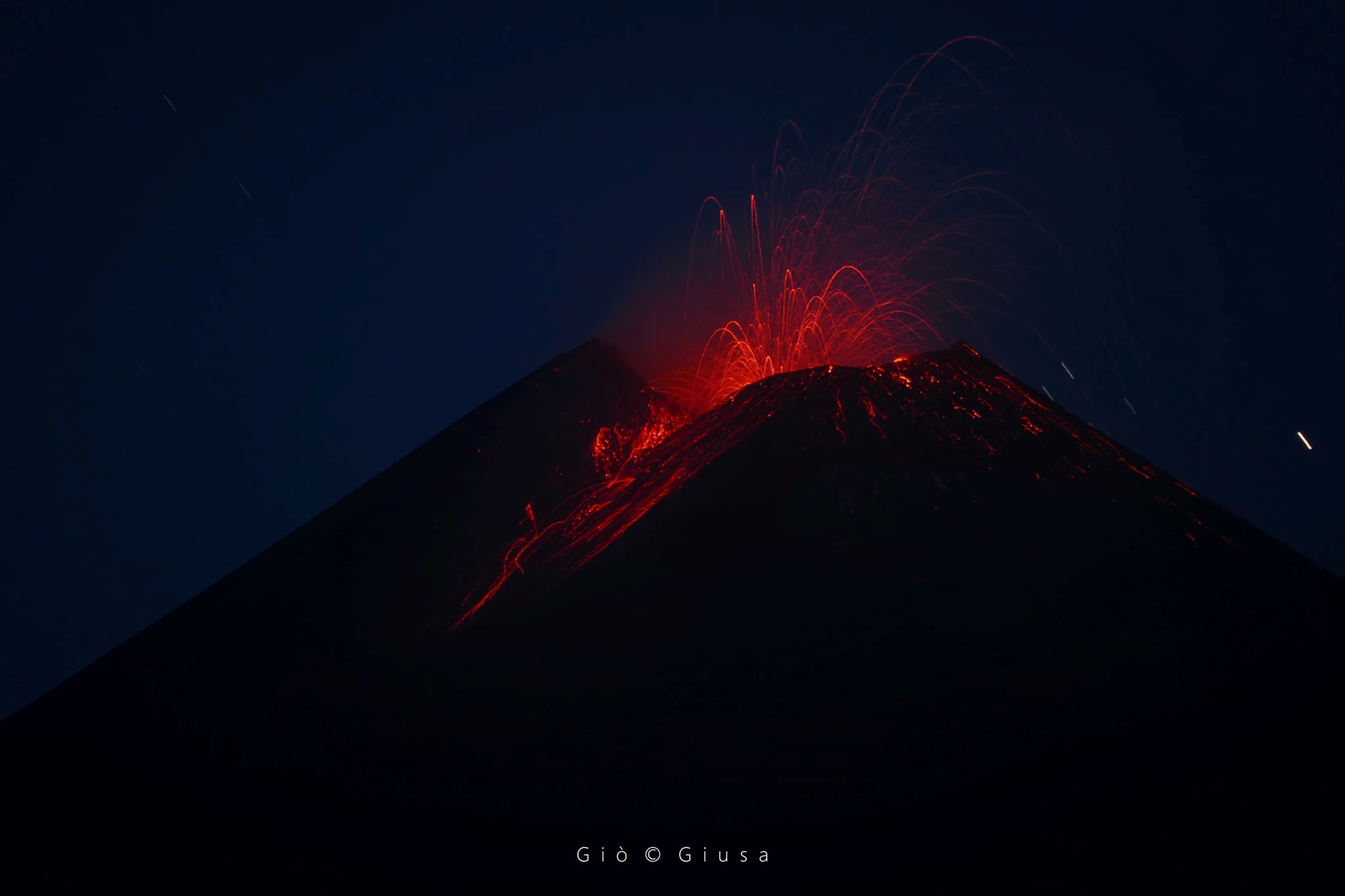
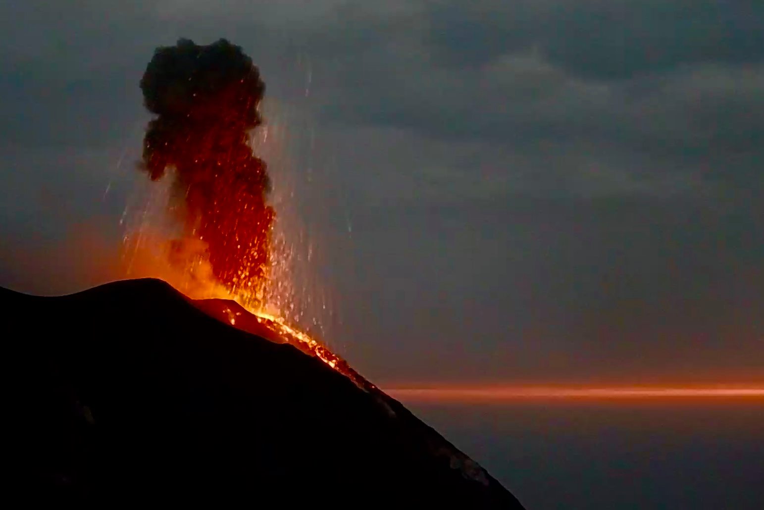
Normal degassing of the summit craters was observed during the visibility intervals; the crater of Bocca Nuova produced frequent puffs of white vapor. The only significant eruptive activity was a single, strong explosion at the eastern mouth of the Southeast Crater, which occurred at 10:30 p.m. UTC on April 24 (12:30 a.m. local time on April 25). This explosion launched coarse incandescent pyroclastic material up to 350m above the vent, which covered the entire southern slope of the cone to its base and beyond. A cloud of ash was blown south by the wind before dispersing into the atmosphere. After the explosion, no other eruptive phenomenon was observed in the Southeast Crater.
Source : INGV
Photo : Gio Giusa.
Italy , Stromboli :
Weekly bulletin from April 19, 2021 to April 25, 2021 (publication date April 27, 2021)
SUMMARY OF THE STATE OF ACTIVITY.
In the light of surveillance data, it is highlighted:
1) VOLCANOLOGICAL OBSERVATIONS: Ordinary explosive volcanic activity of Strombolian type accompanied by sometimes intense projection activity in zone N2. The total frequency of events showed values between average values (13 events / h) and medium-high values (17 events / h). The intensity of the explosions varied from low to medium-high in the North crater area and medium-high in the Center-South area.
2) SEISMOLOGY: The monitored seismological parameters do not show significant variations.
3) DEFORMATIONS: There are no significant changes to report
4) GEOCHEMISTRY: SO2 flow at medium level
C / S ratio: values are on average levels
Helium isotope ratio: the values still show a slight decrease, while remaining on average values.
5) SATELLITE OBSERVATIONS: The thermal activity in the summit area is at a medium-low level.
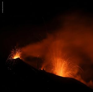
In the period under observation, the eruptive activity of Stromboli was characterized by the analysis of the images recorded by the surveillance cameras INGV-OE located at an altitude of 190 m, Punta Corvi and an altitude of 400 m. Due to adverse weather conditions, on April 19, visibility from the crater terrace was insufficient to describe the eruptive activity.
In the area of the north crater, the N1 crater, with two emission points, produced explosions of varying intensity from low to medium-high (sometimes the products reached 250 m in height) with the emission of coarse materials ( lapilli and bombs) mixed with fine materials (ash). The N2 vent showed low intensity explosive activity with the emission of coarse matter, mainly, and projection activity which peaked on April 24. The average frequency of explosions varied between 11 and 14 events / h.
In the Center-South zone, at least three emission points were observed with explosions emitting mainly coarse materials, of medium intensity and sometimes high (the products exceeded 250 m in height). The explosive activity showed average hourly frequency values between less than 1 and 5 events / h.
Source : INGV
Photo : Webcam
Philippines , Taal :
TAAL VOLCANO BULLETIN 28 April 2021 08:00 A.M.
In the past 24-hour period, the Taal Volcano Network detected two (2) low frequency volcanic earthquakes and low-level background tremor recorded since 9:05 AM on 08 April 2021. Upwelling of hot volcanic fluids in the Main Crater Lake occurred yesterday morning and generated 300-meter tall steam-laden plumes from active fumaroles. Sulfur dioxide (SO2) emission averaged 2,708 tonnes/day on 27 April 2021.
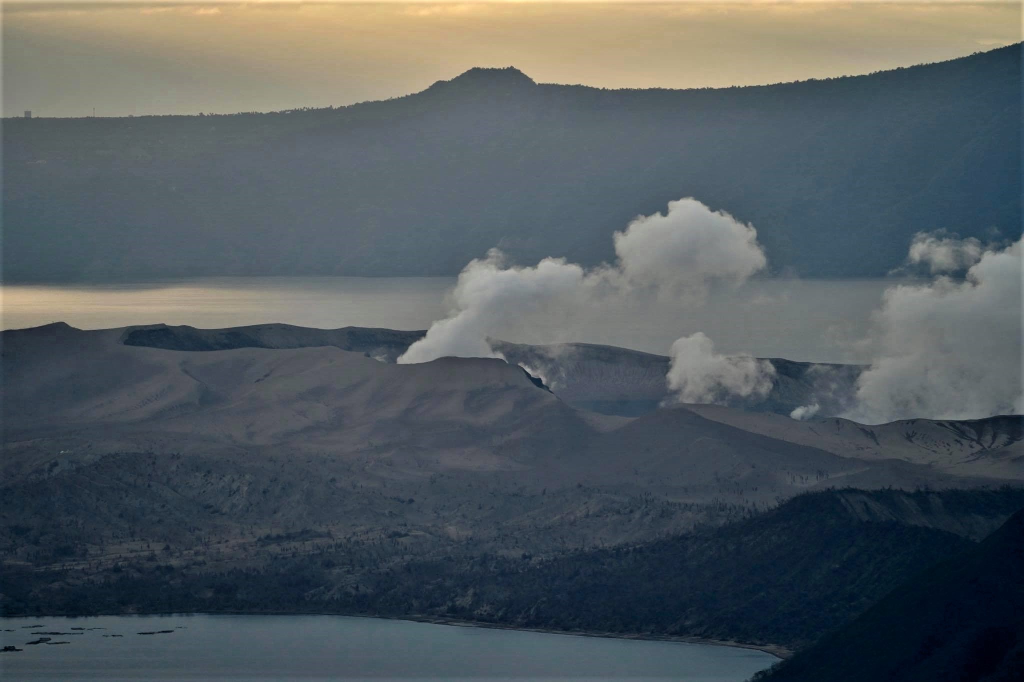
Temperature highs of 71.8°C and pH of 1.59 were last measured from the Main Crater Lake respectively on 04 March and 12 February 2021. Ground deformation parameters from electronic tilt, continuous GPS and InSAR monitoring continue to record a very slow and steady inflation and expansion of the Taal region that began after the January 2020 eruption. These parameters indicate persistent magmatic activity at shallow depths beneath the edifice.
Source : Phivolcs.
Photo : Raffy Tima.
Hawaii , Kilauea :
19°25’16 » N 155°17’13 » W,
Summit Elevation 4091 ft (1247 m)
Current Volcano Alert Level: WATCH
Current Aviation Color Code: ORANGE
Activity Summary:
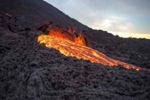
Kīlauea Volcano is erupting. Lava activity is confined to Halemaʻumaʻu with lava erupting from a vent on the northwest side of the crater. This morning, April 27, the lava lake was 227 m (744 ft) deep and remains stagnant over its eastern half. SO2 emission rates remain elevated at 375 t/day, last measured on April 25.
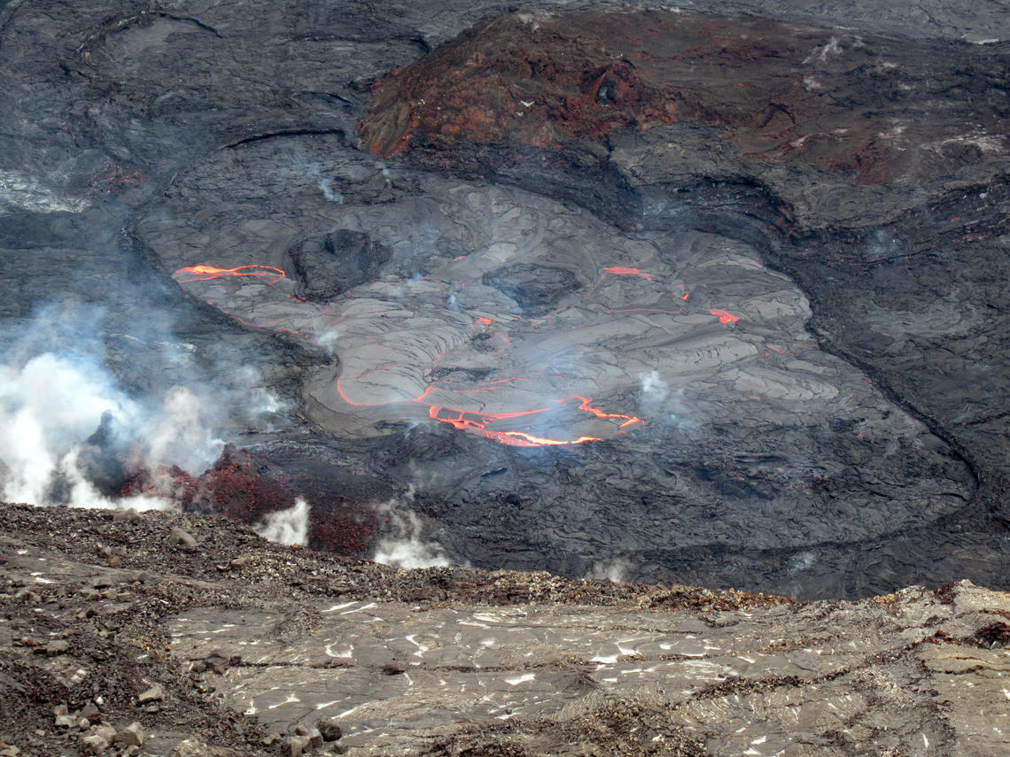
On Monday, April 26, 2021, lava continued to flow from the western vent (bottom left) into the active lava lake (center) in Halema‘uma‘u Crater at the summit of Kīlauea Volcano. The active lava lake surface continues to shrink as areas on the north (upper left) and south (center right) sides cool and solidify. This photograph was taken at 1:03 p.m. HST from the west rim of Halema‘uma‘u.
Summit Observations:
The most recent sulfur dioxide emission rate, measured on April 25, was 375 t/day. This is elevated compared to rates in the months before the eruption started on December 20 (less than 100 t/day), but lower than emission rates from the pre-2018 lava lake (around 5,000 t/day). Summit tiltmeters recorded minor change over the past 24 hours. Seismicity remains stable, with elevated tremor.
East Rift Zone Observations:
No unusual activity noted in the region. Geodetic monitors indicate that the summit and upper East Rift Zone—between the summit and Puʻuʻōʻō—is refilling at rates similar to those measured over the past 2 years and before the December 2020 eruption. SO2 and H2S emissions from Puʻuʻōʻō were below instrumental detection levels when last measured on January 7.
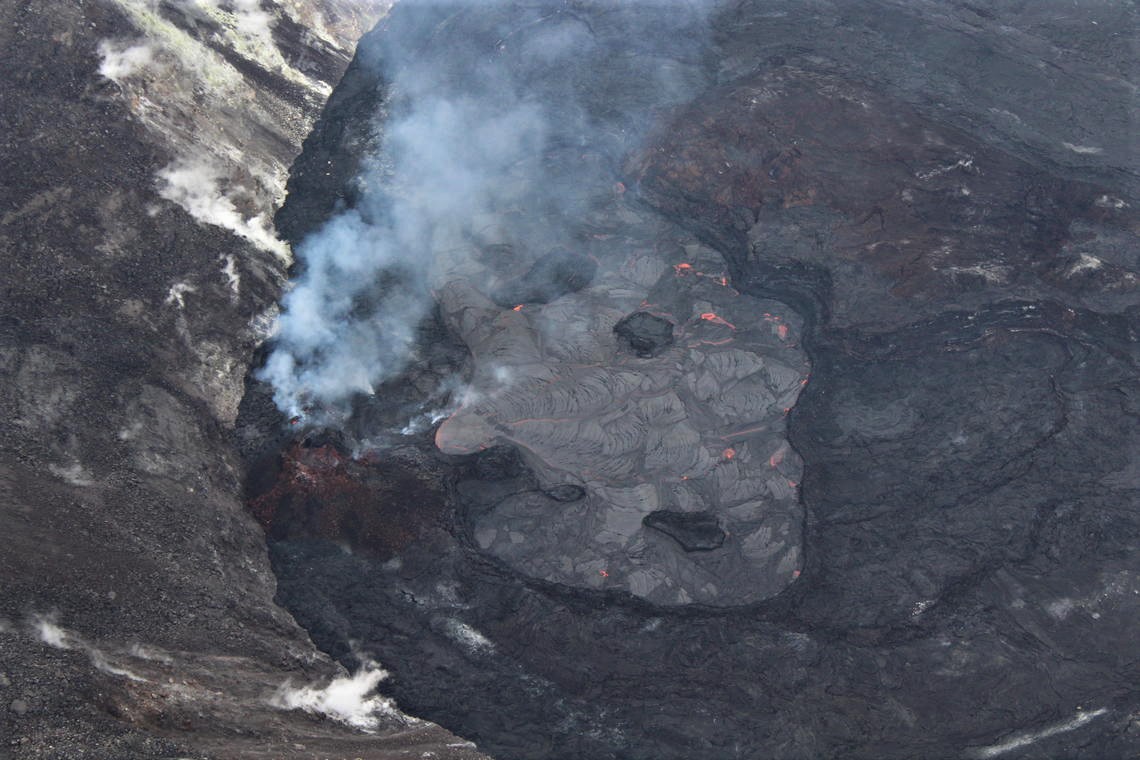
During a Kīlauea summit helicopter overflight on Friday, April 16, an HVO scientist captured this photo of the erupting western fissure and surrounding lava lake within Halema‘uma‘u. The active western potion of the lava lake, as seen here, measured approximately 300 m (984 ft) from end-to-end at the time.
Halemaʻumaʻu Lava Lake Observations:
Lava effusion from the west vent continues to supply the lava lake within Halema‘uma‘u crater through a submerged inlet to the lake. Lava circulation and intermittent foundering of crust continue in a smaller western portion of the lava lake, and lava has not oozed out along the perimeter of the lake over the past week. The total depth of the lake is 227 m (744 ft) this morning as measured by a continuous laser rangefinder on the active western portion. Stagnant and solidified lava crust covered 93% of the lake surface as measured by thermal mapping on April 16th.
Recent SO2 emission rate measurements suggest that the effusion (eruption) rate has decreased over the past week. Past decreases in emissions have occurred while summit tilt was decreasing whereas the recent drop in emissions occurred while summit tilt was slowly increasing during the last week. It is common for eruptions to wax and wane or pause completely. It is unclear if the current decrease in activity will continue and hazardous conditions remain around Halema‘uma‘u crater. HVO continues to monitor Kīlauea volcano closely for any signs of change in activity.
Source : HVO
Photo : USGS / J.M. Chang. USGS.
Saint Vincent , Soufrière Saint Vincent :
La Soufriere SCIENTIFIC UPDATE – 27/04/21 6:00PM
– Seismic activity has remained low with only a few long-period, hybrid and volcano-tectonic earthquakes have been recorded and there was no further tremor.
– Signals from several lahars (mudflows) were recorded between 9 and 10 am today, during and after a period of rainfall.
– A lahar is a rapidly flowing dense mixture of rock debris, ash and water. They have the consistency of wet concrete as they flow and can happen during and after eruptions.
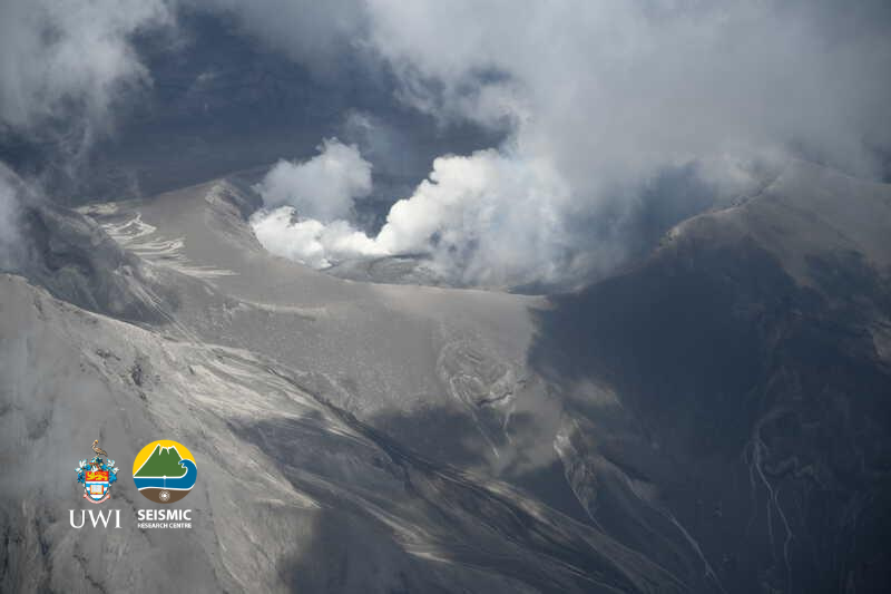
Photo analysis: multiple areas of venting and a possible lava spine . It was noted that tephra has filled the crater so that it now reaches the top of southwestern part of the summit. This can make it easier for pyroclastic density currents PDCs to get out of the summit crater
– Following the rainfall, large amounts of steam could be seen billowing up from a valley south of the summit.
– This would have been generated when the runoff encountered buried volcanic deposits that were still hot.
– The volcano continues to erupt. Explosions with accompanying ashfall, of similar or larger magnitude, can restart with little or no warning.
– The volcano is at alert level Red.
Source : UWI
Photo : Roderick Stewart, MVO/UWI-SRC.