January 16 , 2023 .
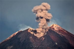
Indonesia , Dieng Plateau :
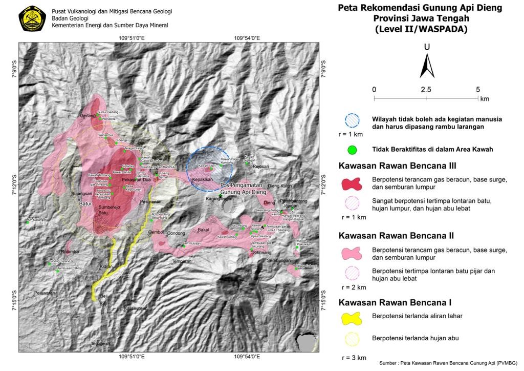
Increased the activity level of G. Dieng from level I (normal) to level II (Waspada), January 14, 2023
Introduction
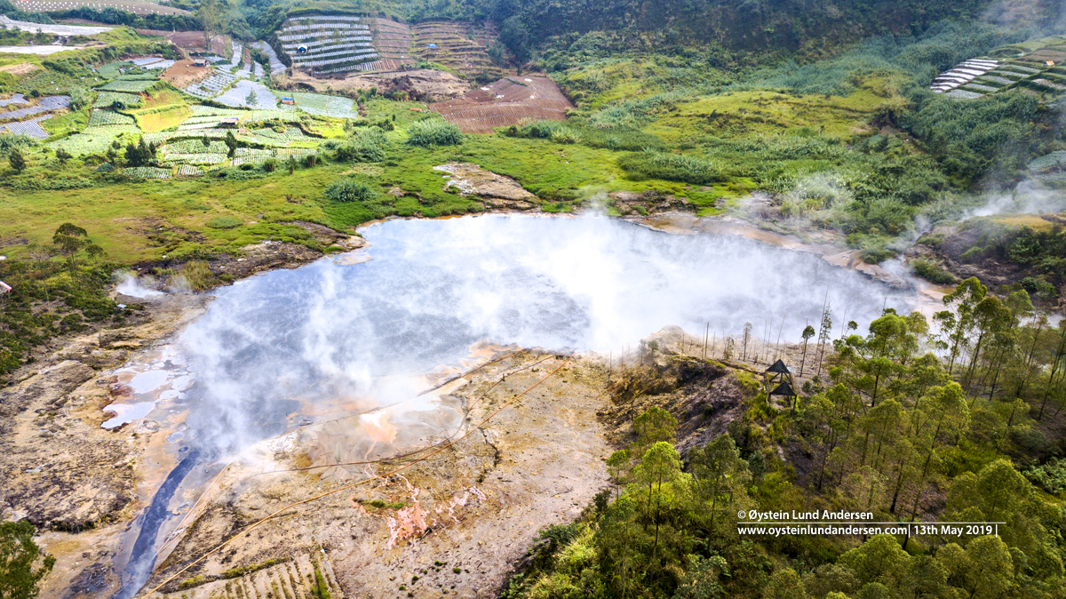
The Dieng volcano has several volcanic cones and several fumarole fields. Over the past 20 years, Timbang Crater and Sileri Crater have experienced increased activity and eruptions.
The last activity in the Sileri crater occurred on April 29, 2021 in the form of a phreatic eruption. This eruption had not been preceded by a significant increase in volcanic earthquakes, which indicated that there was no supply of magma rising to the surface, the eruption had been caused by the accumulation of water vapor pressure at a shallow level below the surface. The ejected material was mud with a radius of less than 500 meters.
Further activity occurred at Siglagah Crater in July 2021 in the form of a phreatic eruption and mudslide with a radius of approximately 10 meters. The material from the eruption was in the form of mud, accompanied by a thud that was sometimes heard 100 meters away.
Visual and instrumental observations
Visual
The smoke from the Sileri crater is white, at low pressure, with a low to thick intensity, the height of the smoke is between 10 and 60 meters from the surface of the crater. There is no visible gas flow from the Timbang Crater.
In the period from January 8, 2023 to January 13, 2023, the weather is sunny to rainy, the wind is weak to strong. The air temperature is around 12-20°C. The smoke from the Sileri crater is white, at low pressure, with a low to thick intensity, the height of the smoke is between 10 and 60 meters from the surface of the crater. There is no visible gas flow from the Timbang Crater.
Instrumental
During the period from January 1, 2023 to January 7, 2023, 14 local tectonic earthquakes were recorded with amplitudes of 8-42.7 mm and earthquake durations of 7.3-15.2 seconds. 1 distant tectonic earthquake with an amplitude of 40.1 mm, and a duration of 108 seconds.
During the period from January 8, 2023 to January 13, 2023, 6 deep volcanic earthquakes were recorded with an amplitude of 13.4-42.7 mm, and a duration of 6.4-13.2 seconds, 170 Local tectonic earthquakes with amplitudes of 5.3 to 42.7 mm, and durations of 5.87 to 22.5 seconds, 2 earthquakes felt with an amplitude of 42.7 mm, and a duration of 25.5 at 38.3 seconds and finally 5 distant Tectonic earthquakes with an amplitude of 12-42.7 mm and a duration of 23-449.2 seconds.
Risk and potential assessment
Based on visual and instrumental observational data, there has been an increase in volcanic activity, as indicated by an increase in the frequency of deep volcanic earthquakes and local tectonic earthquakes since January 9. 2023. This could indicate « fractures » below the surface, consequences of the volcanic activity of the Dieng volcano.
The results of CO2 gas measurements in the Timbang Crater during the period from January 1, 2023 to January 13, 2023 tend to increase with an average between 0.09% and 0.11%. While the results of measuring the water temperature of the Sileri crater during the period from January 1, 2023 to January 13, 2023 were between 68.5 and 68.6 oC and the ground temperature in the crater Sileri showed between 21.6 and 21.7 oC, indicating relative stability.
The potential danger that could arise due to the increase in volcanic activity in Dieng at this time is the increasing concentration of volcanic gases, in particular CO2 in the Timbang crater, which may be followed by the appearance of a CO2 gas flow; and phreatic eruptions in the Sileri crater in the form of mudslides or ejections of material. Phreatic eruptions or mudslides can occur without being preceded by an increase in visual and seismic activity.
Conclusion:
Based on the results of a thorough assessment, the activity level of G.Dieng has been raised from Level I (normal) to Level II (WASPADA) from January 13, 2023 at 23:00 WIB with recommendations adjusted to the latest threat potential.
Source : PVMBG.
Photos : PVMBG , Oystein Lund Andersen.
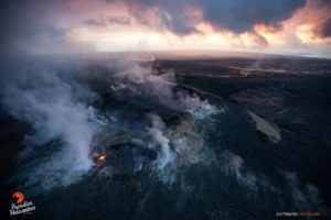
Hawaii , Kilauea :
Sunday, January 15, 2023, 8:59 AM HST (Sunday, January 15, 2023, 18:59 UTC)
19°25’16 » N 155°17’13 » W,
Summit Elevation 4091 ft (1247 m)
Current Volcano Alert Level: WATCH
Current Aviation Color Code: ORANGE
Activity Summary:
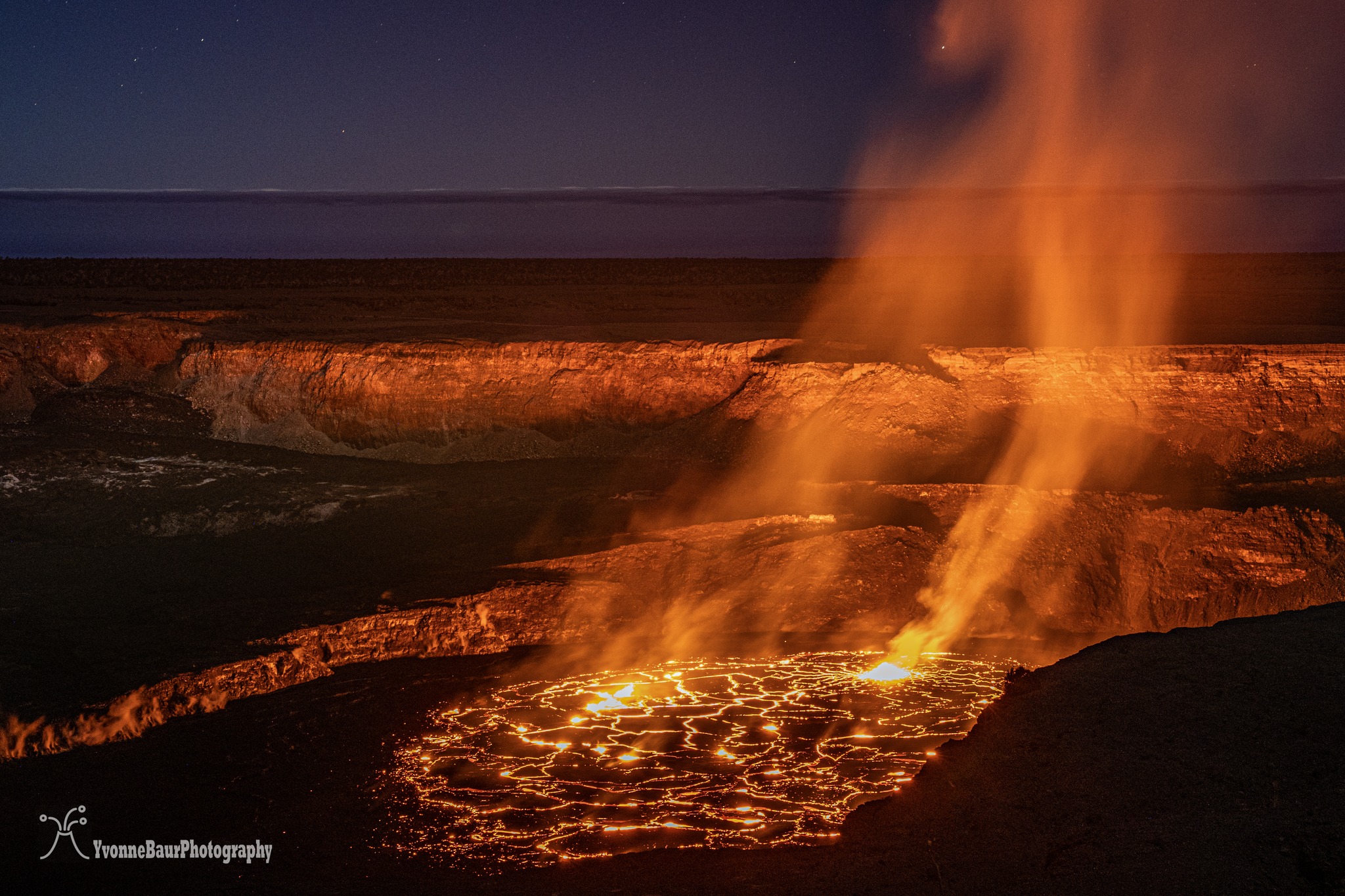
The summit eruption of Kīlauea Volcano, within Halemaʻumaʻu crater, continued over the past 24 hours. All recent eruptive activity has been confined to the crater. No significant changes have been observed at the summit or in either rift zone.
Halemaʻumaʻu Lava Lake Observations:
Eruption of lava in the eastern portion of Halemaʻumaʻu crater floor continued over the past 24 hours. Activity is concentrated in a large lava lake in the eastern half of the crater, as well as a smaller area of lava within the basin in the western half of the crater that was the focus of activity in 2021–2022. The active lava lake in the eastern half of the crater has one dominant fountain, measured at 6-7 yards (meters) high. The eastern lava lake had an area of approximately 30 acres (12 hectares) on January 10, and the surface area has fluctuated slightly over the past 24 hours with several small overflows from the perched lake.
Observations du sommet :
Au cours des dernières 24 heures, les inclinomètres du sommet ont montré une inclinaison inflationniste qui a commencé juste avant minuit et se poursuit ce matin. Le tremor volcanique reste au-dessus des niveaux de fond. Un taux d’émission de dioxyde de soufre (SO2) d’environ 3 500 tonnes par jour (t/j) a été mesuré le 9 janvier 2023.
Observations de la zone de Rift :
Aucune activité inhabituelle n’a été notée le long de la zone de rift Est ou de la zone de rift Sud-Ouest ; de faibles taux de déformation du sol et de sismicité se poursuivent le long des deux. Les mesures des stations de surveillance continue des gaz sous le vent de Puʻuʻōʻō dans la zone du Rift du Sud-Est ont été inférieures aux limites de détection de SO2, ce qui indique que les émissions de SO2 de Puʻuʻōʻō sont négligeables.
Source : HVO.
Photo : Yvonne Baur via Hawaii tracker .
Chile , Nevados de Chillan :
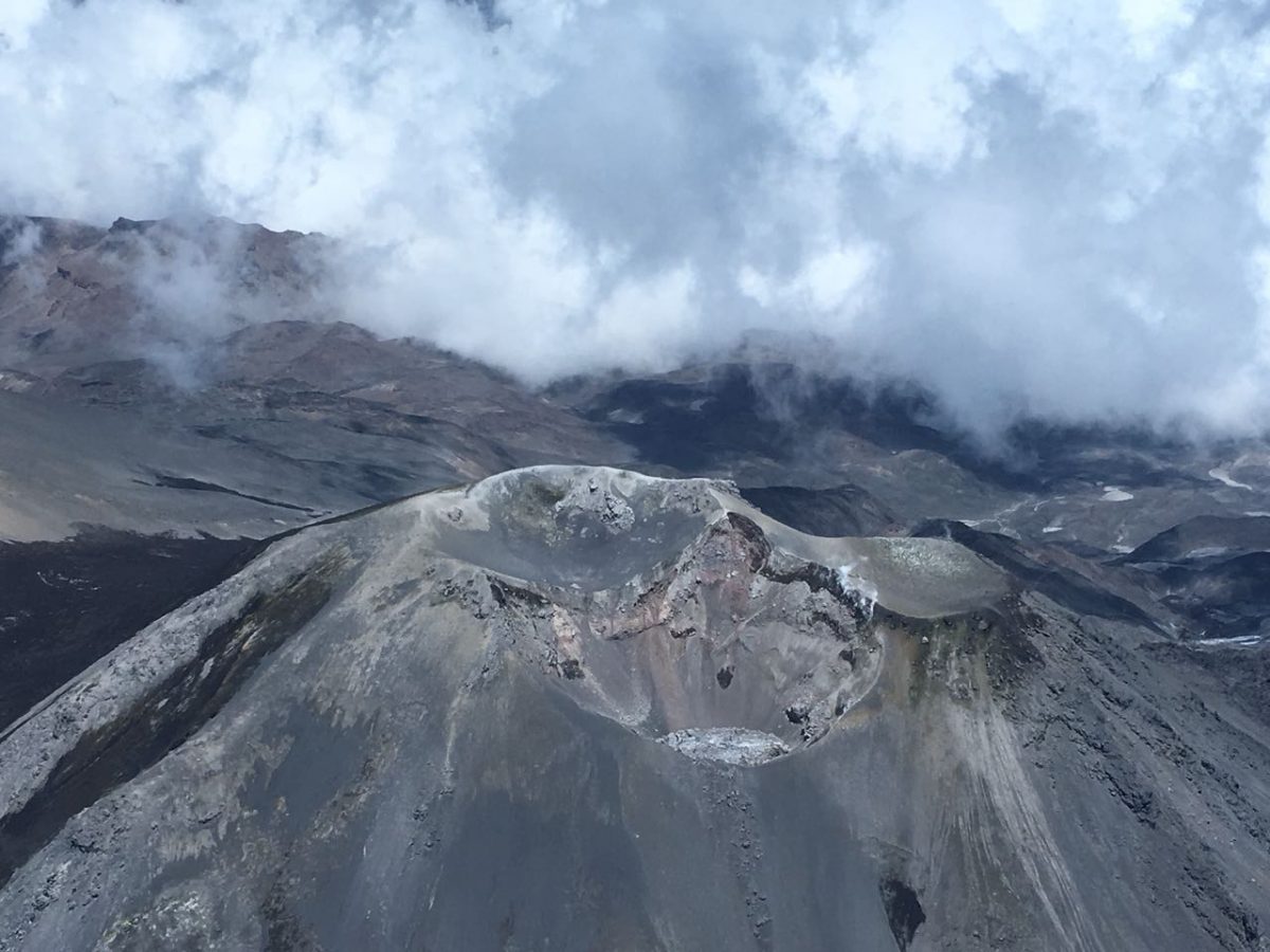
– After 6 years and 10 months, the massif returns to a normal state, which has led the institution in charge of monitoring active volcanoes in Chile to modify its alert level.
the National Geology and Mining Service (Sernageomin) decided to lower the Nevados de Chillán volcanic complex to a green technical alert, which had been yellow since 2015, in an eruptive process that lasted more than 7 years. The beginnings resulted in the creation of several small craters which gave way to a larger crater called Nicanor, where much of the activity of the eruptive process was concentrated, generating 8 lava flows which did not have exceeded 2 kilometers in length. Some lava domes also formed causing minor explosions and the emission of fine ash which on some occasions was seen in nearby towns such as Las Trancas.
During this period, the Volcanic Complex reached the maximum orange technical alert in 2018 with the emergence of a large dome which was destroyed after a few months. The determination to lower the green alert is based on the fact that since mid-October 2022 the volcanic complex has not exhibited surface activity, although the Sernageomin has maintained a yellow alert for a few more months. since the volcano was still showing signs of internal activity. However, it has been concluded that there is currently not enough energy or matter released to the surface.
For Álvaro Amigo, Deputy National Director of Geology (s) of Sernageomin, « it was an eruptive cycle that left us with many lessons, where we intensified monitoring through satellite sensors, which allowed us to obtain high-resolution images to identify surface changes, the analysis of thermal anomalies, movements and deformations thanks to radar sensors and the construction of digital elevation models.It has also made it possible to strengthen coordination with SENAPRED of Biobío, which in the eruptive process became part of the new region of Ñuble.
It is important to emphasize that a danger zone of 500 meters will be maintained around the active crater, considering that specific events related to the activity of the volcano could occur.
Source et photo : Sernageomin
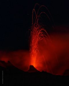
Guatemala , Santiaguito :
Activity:
Presence of a constant degassing at 600 meters above the Caliente dome, moving towards the South-West. Likewise, the incandescence observed during the night and in the early morning in the dome of the Caliente dome, remains constant. Seismic stations continue to record low explosions, and reports from field observers indicate that some are generating low to moderate rumblings. Weak to moderate avalanches are generated from the dome of the Caliente dome.

The lava flow continues to be active on the southwest and west flanks, causing degassing and weak avalanches along its path. This causes a fall of fine ash particles and a foggy environment near the volcano. Explosions, strong avalanches and audible sounds can be generated several kilometers from the volcanic edifice. The appearance of block and ash flows of moderate to strong characteristics is not excluded, as well as possible pyroclastic flows over long distances in different directions.
Source : Insivumeh
Photo : Armando Pineda
Costa Rica , Turrialba / Poas / Rincon de la Vieja :
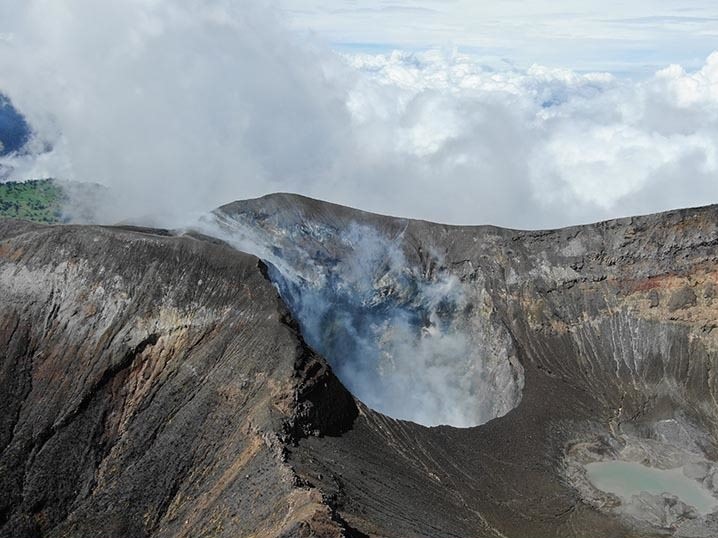
Turrialba Volcano
Observed activity:
Volcanic activity has remained stable and at a very low level for several months, with a relatively low number of daily volcanic earthquakes of low to moderate amplitude (LP type). No eruption or volcanic tremor was recorded. The composition and flow of the gases remain stable. The fumaroles around the West crater (also called Murciélago crater) remain vigorous and rich in water vapour. The MultiGAS gas detection system located near the West Crater does not record significant changes in the gases with values similar to those recorded over the past 2 years: CO2/SO2 around 10, H2S/SO2 close to 0 ,2; and SO2 between 2 and 5 parts per million.
The sensors of the gas and aerosol monitoring station located at EMVA Coronado (downwind of the Turrialba volcano), recorded the lowest concentrations of SO2 and aerosols (PM10, PM2.5, PM1) in the air ambient between October 2021 and currently for the period of the last 2 years 2021-2023. Since October 2021, SO2 has remained below 2 parts per billion and PM10 below 20 ug/m3. If we compare these data with those recorded in the periods when the Turrialba and Poás volcanoes had magmatic degassing, we can see a substantial difference. The satellites also detect little mass of SO2 gas emitted by the Poás and Turrialba volcanoes after the years 2017-2018.
Activity Level: Warning (2)
Poas Volcano
Observed activity:
Volcanic activity remained stable for several months with no trace of eruptions, and with few volcanic earthquakes of low frequency and very low magnitude (LP type). However, the seismographs record a weak background seismic signal, background volcanic tremor with dominant frequencies at 3, 7 and 10 Hz. The fumaroles under the hyperacid lake and in the eastern sector of the active crater remain active degassing mainly d water at a temperature below 100 degrees Celsius.
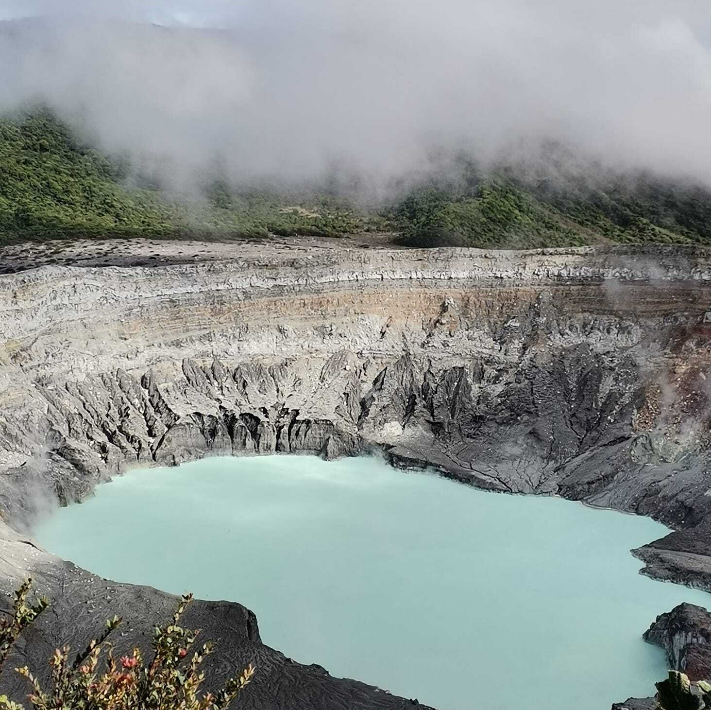
The gas detection system (ExpoGAS) located on the gazebo recorded SO2 concentrations below 0.4 parts per million. The gas detection system located west of the active crater (MultiGAS) records a composition and a stable gas flow similar to those observed over the past 2 years: CO2/SO2 around 1.8, H2S/SO2 around 0 .1 and SO2 between 0.6 and 2.2 parts per million. The Poás GPS network shows a slight deflation of the volcanic edifice. The hyperacidic lake appears relatively calm and retains a milky green color due to the presence of submarine vents.
Activity Level: Warning (2)
Rincon de la Vieja Volcano
Observed activity:
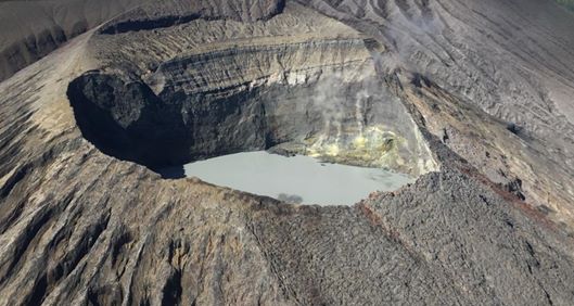
Seismographs do not record eruptions, but they do record a moderate signal of intermittent background volcanic tremor with frequencies around 2 Hz. Over the past two days, a few low frequency, moderate amplitude volcanic earthquakes , « tornillos » type earthquakes and volcano-tectonic earthquakes have been recorded.
Activity Level: Warning (2)
Source : Ovsicori .
Photos : G. Avard / Ovsicori , Ovsicori , Chris Allen de Sunquest Helitours