July 19 , 2022.
Indonesia , Anak Krakatau :
VOLCANO OBSERVATORY NOTICE FOR AVIATION – VONA
Issued : July 18 , 2022
Volcano : Anak Krakatau (262000)
Current Aviation Colour Code : ORANGE
Previous Aviation Colour Code : orange
Source : Anak Krakatau Volcano Observatory
Notice Number : 2022KRA66
Volcano Location : S 06 deg 06 min 07 sec E 105 deg 25 min 23 sec
Area : Lampung, Indonesia
Summit Elevation : 502 FT (157 M)
Volcanic Activity Summary :
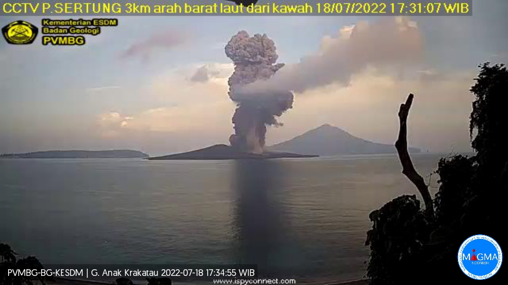
Eruption with ash clouds at 10h30 UTC (17h30 local time). The eruption lasted for 73 seconds.
Eruption with ash clouds at 08:49 UTC (15:49 local time). The eruption lasted for 97 seconds
Eruption with ash clouds at 01:26 UTC (08:26 local time). The eruption lasted for 127seconds.
Volcanic Cloud Height :
Best estimate of ash-cloud top is around 8502 FT (2657 M) above sea level, may be higher than what can be observed clearly. Source of height data: ground observer.
Other Volcanic Cloud Information :
Visuals directly from the cctv were observed eruptions with the color of the thick grey eruption smoke 2500m from the top of the volcano, the wind direction slowly to the southwest.
Remarks :
Eruption recorded on seismogram with maximum amplitude 55 mm and maximum duration 73 second.
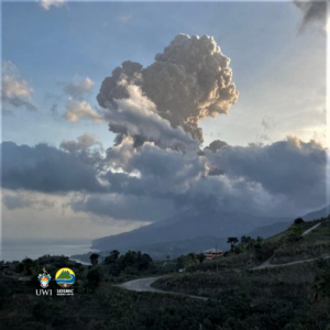
Mount Anak Krakatau erupted on Monday, July 18, 2022 at 5:30 p.m. WIB with an ash column height observed at ± 2500 m above the summit (± 2657 m above sea level). The ash column is observed to be gray with a thick intensity oriented towards the Southwest. This eruption was recorded on a seismograph with a maximum amplitude of 55 mm and a duration of 73 seconds.
Source : Magma Indonésie .
Guatemala , Fuego :
Weather conditions: Clear weather
Wind: East
Precipitation: 0.0 mm
Activity:
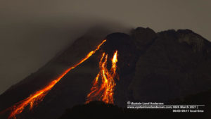
The Fuego volcano observatory reports a weak white fumarole at a height of 4,500 meters above sea level which is spreading in a West-South-West direction. 5 to 9 weak and moderate explosions per hour have been recorded, these explosions generate columns of ash at a height of 4,500 to 4,800 meters above sea level (14,764 to 15,748 feet) which extend from 10 to 15 kilometers in a west-southwest direction.
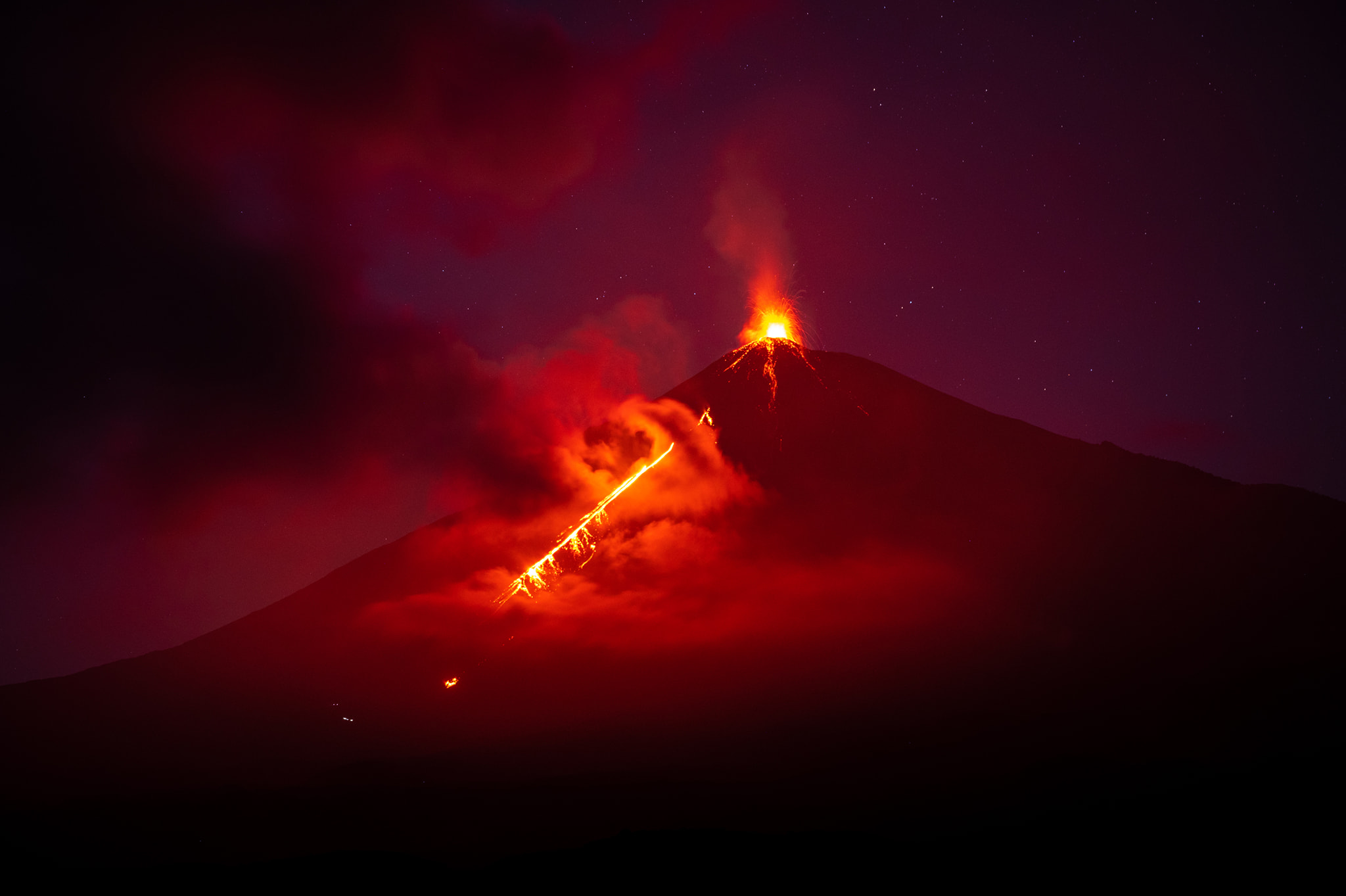
These explosions generated low rumblings with a weak shock wave that vibrated the roofs and windows of houses near the volcano. A luminescent pulse was observed 100 to 200 meters above the crater. This generated weak to moderate avalanches around the crater and towards the ravines of Santa Teresa, Ceniza, Trinidad and Las Lajas. Faint sounds similar to a train locomotive were heard with a time lapse of 1-2 minutes. Fine ash falls are reported in Panimaché I, Panimaché II, Morelia, Santa Sofía, El Porvenir, Sangre de Cristo, Yepocapa and other communities in this direction.
Source : Insivumeh.
Photo : Diego Rizzo (Archive)
Peru , Sabancaya :
Analysis period: from July 11, 2022 to July 17, 2022, Arequipa, July 18, 2022.
Alert level: ORANGE
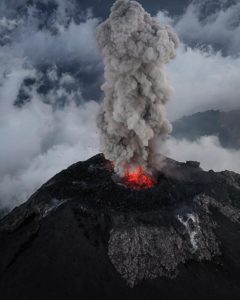
The Geophysical Institute of Peru (IGP) reports that the eruptive activity of the Sabancaya volcano remains at moderate levels, that is to say with the recording of an average of 28 daily explosions, with columns of ash and of gas up to 2.7 km altitude above the summit of the volcano and their subsequent dispersion. Therefore, for the following days, no significant change is expected in eruptive activity.
The IGP recorded and analyzed the occurrence of 260 earthquakes of volcanic origin, associated with the circulation of magmatic fluids inside the Sabancaya volcano. An average of 28 explosions was recorded daily, in addition to recording Volcano-Tectonic (VT) type events associated with rock fracturing inside the Sabancaya volcano.
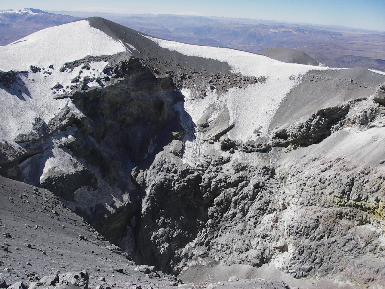
Monitoring the deformation of the volcanic structure using GNSS techniques (processed with fast orbits) does not show any significant anomalies. However, in general, an inflation process has been observed in the northern sector (surroundings of the Hualca Hualca volcano). Visual surveillance identified columns of gas and ash up to 2.7 km above the summit of the volcano, which were scattered towards the southeast and east sectors of Sabancaya. Satellite recordings have identified the presence of 8 thermal anomalies, with a maximum value of 15 MW, associated with the presence of a lava body on the surface of the volcano’s crater.
RECOMMENDATIONS
• Keep the volcanic alert level orange.
• Do not approach within a radius of less than 12 km from the crater.
Source : Cenvul
Photo : Ingemmet
Alaska , Great Sitkin :
52 4’35 » N 176 6’39 » W,
Summit Elevation 5709 ft (1740 m)
Current Volcano Alert Level: WATCH
Current Aviation Color Code: ORANGE
Low-level eruption of lava continues at Great Sitkin. Elevated surface temperatures were observed in satellite data. Seismicity remains low with occasional local earthquakes over the past day. No activity was observed in cloudy web camera views of the volcano. It is possible that new explosive activity could occur with little or no warning.
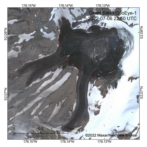
GeoEye-1 satellite image of the lava flow field in the summit crater and upper flanks of Great Sitkin Volcano on 6 July 2022. The eruption of lava has continued at a slow rate from a vent in the center of the summit crater. The flow field has been growing to the northeast into the summit glacier, which is collapsing (see concentric curved crevasses) from melting due to lava interaction.
Great Sitkin is monitored by local seismic and infrasound sensors, satellite data, web cameras, and remote infrasound and lightning networks.
Source : AVO.
Photo : Dietterich, Hannah.
Philippines , Bulusan :
Despite showing a sustained drop in seismic activity in the past week, Bulusan Volcano’s condition remains abnormal as its other parameters continue to be high, the Philippine Institute of Volcanology and Seismology (Phivolcs) reported yesterday.
Winchille Sevilla, science research specialist at Phivolcs, said the sudden drop in volcanic earthquakes means that degassing activities inside the volcano are not strong enough to cause movements in the volcanic faults.
But Sevilla said the low tremors do not necessarily mean that the volcano is returning to its normal condition.
“We can only tell that Bulusan is going back to normal if the drop in its volcanic tremors is accompanied by a decrease in the sulfur dioxide and plume emissions.
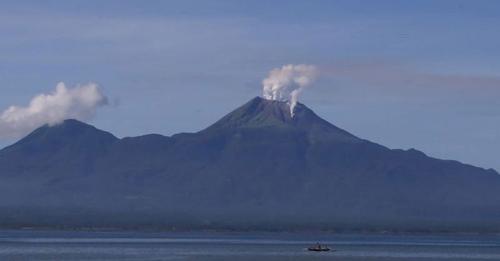
Six volcanic quakes, 128 tons of sulfur dioxide and a plume emission of 500 meters above the main crater were recorded yesterday, Phivolcs said.
On Sunday, Bulusan generated four volcanic quakes, 919 tons of sulfur dioxide and a half-kilometer-high plume emission.
“The figures in the abnormal signs tell us that hydrothermal activities are ongoing inside the volcano and can lead to a phreatic eruption any time,” he added.
Phivolcs said more weeks of observation are needed before it could conclude an upward or downward trend in the overall condition of the volcano.
Phivolcs warned the public against entering the permanent and extended danger zones around the volcano due to the possibility of sudden hazardous phreatic eruptions.
Source : Philstar via Manfred Meyer.
Read the article : https://www.philstar.com/nation/2022/07/19/2196348/bulusan-sustains-drop-seismic-activity?fbclid=IwAR1cTd3WUzhA0JsDHVd0mXuUESs09I2G2Js0-S11BKZx_CdDHdcZ-cM0H2A
Hawaii , Kilauea :
19°25’16 » N 155°17’13 » W,
Summit Elevation 4091 ft (1247 m)
Current Volcano Alert Level: WATCH
Current Aviation Color Code: ORANGE
Activity Summary:
The summit eruption of Kīlauea Volcano, within Halemaʻumaʻu crater, has continued over the past 24 hours. All recent lava activity has been confined to the crater and current data indicate that this scenario is likely to continue. No significant changes have been noted at the summit or in either rift zone.
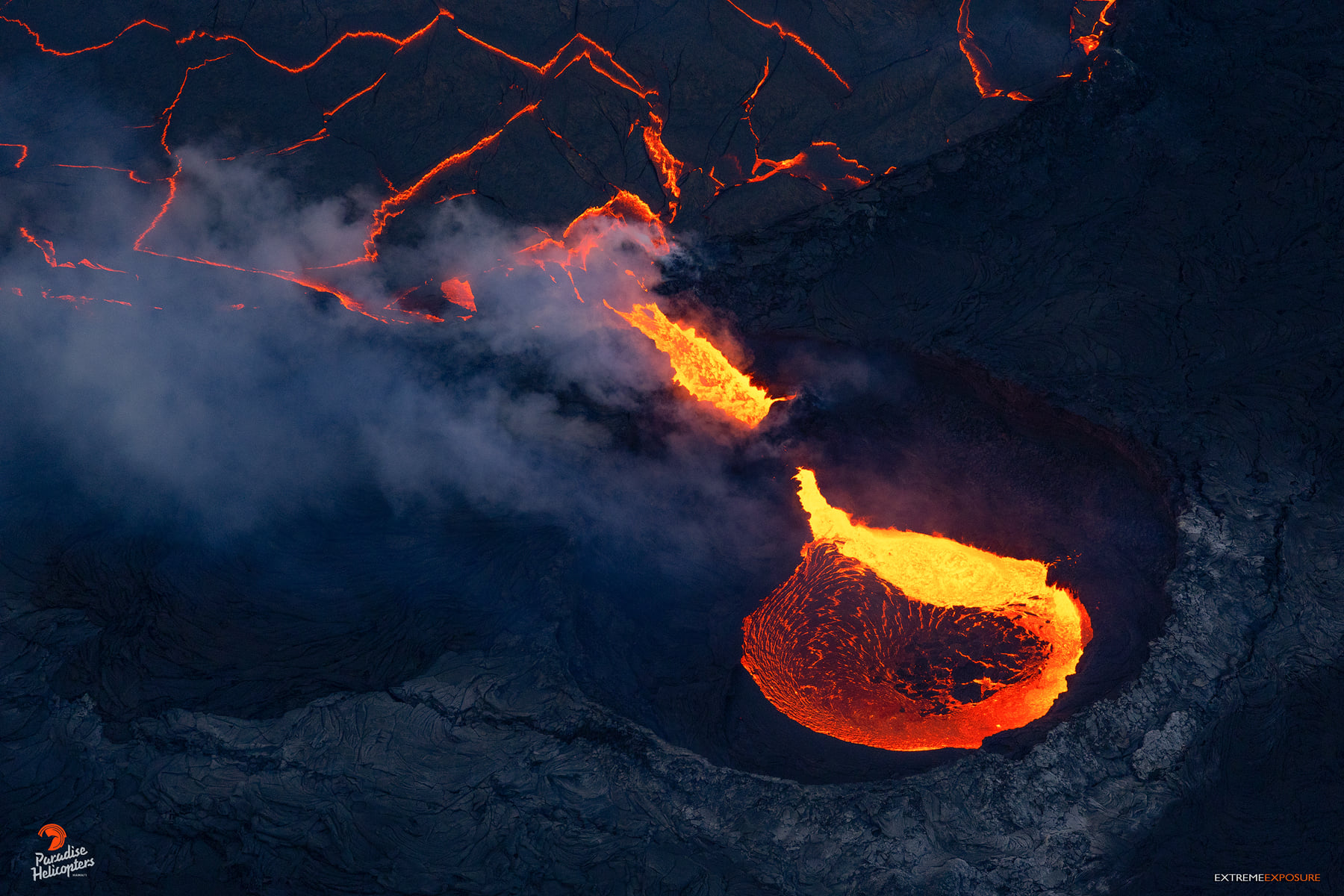
Summit Observations:
Eruption of lava from the Halemaʻumaʻu western vent into the active lava lake has continued over the past 24 hours. The lava level of the active lake surface remained at the level of the bounding levees. Overnight webcam views showed glow in the western vent complex. Measurements from an overflight on July 7, 2022 indicated that the crater floor had seen a total rise of about 130 meters (427 feet) . Summit tiltmeters began a short-lived deflationary trend around 07:30 pm HST last night, and transitioned to a flat trend just after 6 am HST this morning. A sulfur dioxide (SO2) emission rate of approximately 1,500 tonnes per day (t/d) was measured on July 15, 2022. Summit tremor is steady for this eruption’s long term base-line level.
Rift Zone Observations:
No unusual activity has been noted along the East Rift Zone or Southwest Rift Zone; steady rates of ground deformation and seismicity continue along both. Measurements from continuous gas monitoring stations downwind of Puʻuʻōʻō in the middle East Rift Zone remain below detection limits for SO2, indicating that SO2 emissions from Puʻuʻōʻō are negligible.
Source : HVO.
Photo : Bruce Omori