April 17 , 2021.
Saint Vincent , Soufrière Saint Vincent :
University of the West Indies Seismic Research Centre (UWI-SRC) and National Emergency Management Organisation (NEMO) reported that the effusive eruption at Soufrière St. Vincent (often simply referred to as “La Soufriere”) became explosive on 9 April after a period of increased seismicity, gas emission, and rapid dome growth. Earthquake swarms were recorded during 22-25 March and 5 April, signifying a change in the eruption pattern. Small earthquakes associated with dome growth were recorded on 7 April. Episodes of tremor indicating movement of magma and fluids close to the surface began at 0300 on 8 April and were again recorded at 0530, 0800, 1015, and 1300, slowly increasing in magnitude. Five long-period earthquakes and two brief swarms of VT events occurred in between the tremor episodes; ash venting occurred with the last episode. Sulfur dioxide emissions were identified in satellite data, and clouds of steam and gas were visible from the Belmont Observatory. Later that evening, incandescent material over the vent area was visible in webcam images, and views from the observatory indicated that the dome had grown significantly. The Alert Level was raised to Red at around 1830, and the Prime Minister issued an evacuation order for the Red Zone at the N part of the island, affecting 16,000-20,000 people.
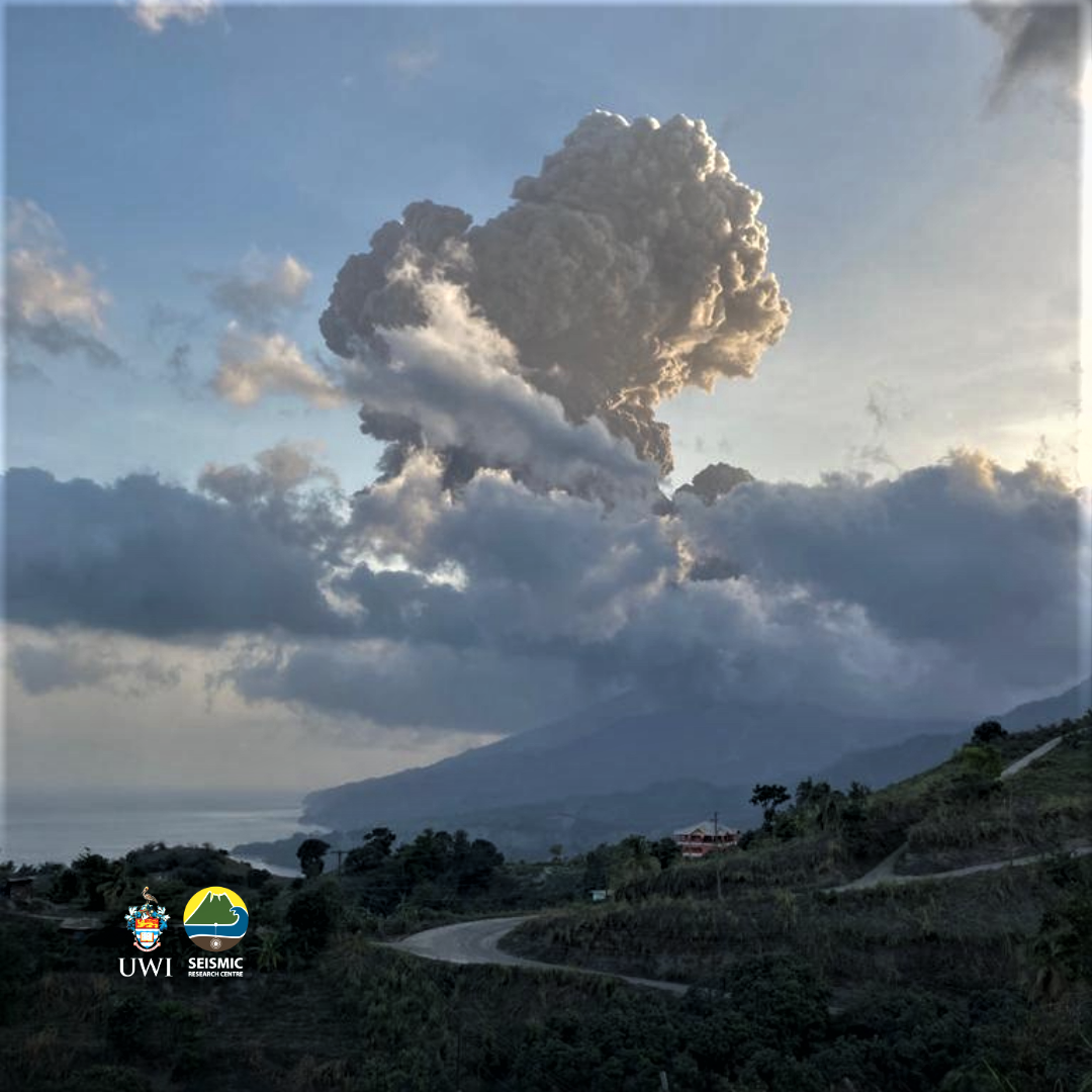
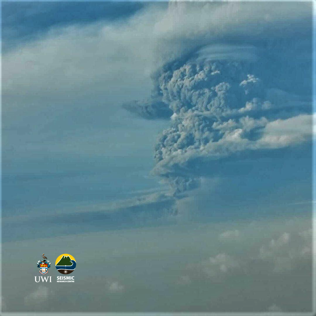
An explosive eruption began at 0840 on 9 April when an ash plume rose to 8 km (27,900 ft) a.s.l. and drifted mainly ENE. Ash fell across the island, affecting communities including Chateaubelair and Petite Bordel, the observatory, Belmont and surrounding areas at the S end of the island, and forcing the closure of the Argyle International Airport (20 km S). NEMO stated that evacuations in the Orange and Red zones were impeded by significant ashfall and poor visibility, but by the evening most residents had been evacuated. A second period of vigorous ash venting began at 1445 and initially rose about 4 km (13,100 ft) a.s.l. Lightning was visible in the rising plume. Successive explosions and ash pulses fed the plume for hours and it rose to 16 km (52,000 ft) a.s.l. A third explosive series began at 1835. Ash venting occurred through the night, causing ashfall across St. Vincent and reaching Barbados, about 165 km E, significantly impacting residents on that island.
Periods of banded tremor began at 0330 on 10 April, lasting for periods of 20-30 minutes with 1-3-hour gaps. The tremor episodes were associated with explosive activity and stronger pulses of ash emissions to higher altitudes; ash plumes rose to 10.6-16 km (35,000-52,000 ft) a.s.l. throughout the day. The Washington VAAC stated that ash plumes during 9-10 April had drifted as far as 1,200 km ESE and about 3,000 km ENE. The Grantley Adams International Airport (GAIA) in Barbados also closed.
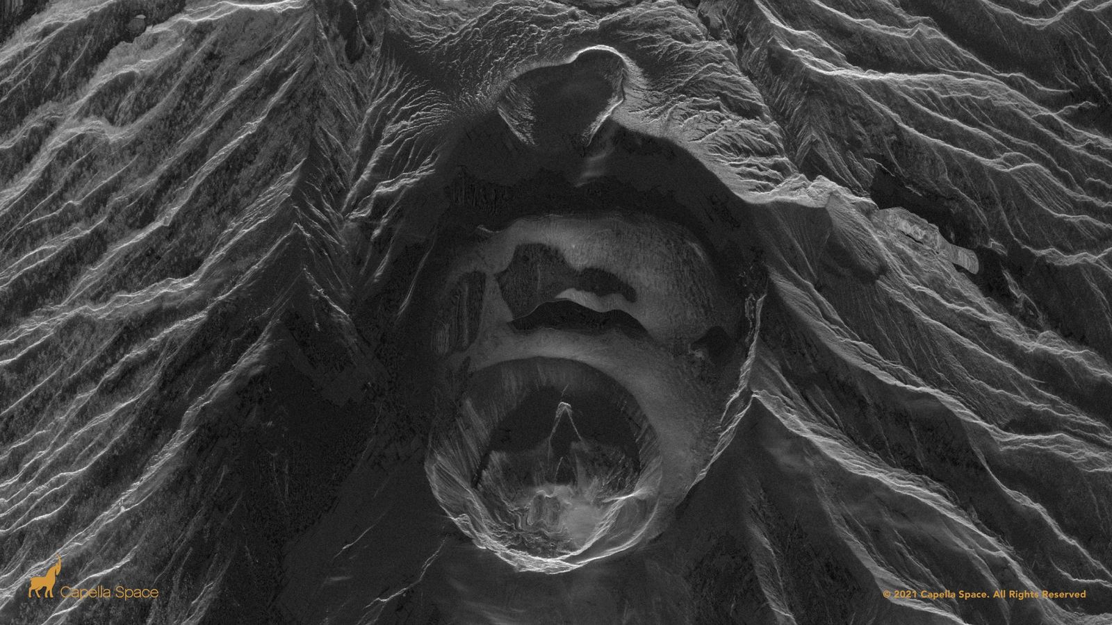
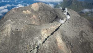
14 April 2021. This satellite radar image shows changes to the La Soufriere volcano on St Vincent.
In the middle of the image is the large depression that is the summit crater that used to contain the lava domes from 1979 and 2021.The explosions that began on 9 April 2021 have destroyed both domes, creating a smaller crater that measures about 800 m in diameter. The base of this crater is very distorted in the image due to the presence of the ash in the air, the ongoing eruption and the way that radar images are acquired. Photo credit: Capella Space Photo analysis: Dr Adam Stinton / Montserrat Volcano Observatory
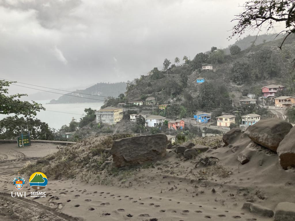
Ashfall continued to be widespread on 10 April; deposit thickness varied from less than 1 mm in Colonaire (~12.5 km SSE) to 10-15 mm in Rabacca (~7.4 km SSE). Scientists reported darkness at the observatory at 1617; video showed intense and continuous ashfall. Satellite data confirmed that explosions had excavated the 2020-2021 lava dome and parts of the 1979 dome, leaving a large crater.
Overnight during 10-11 April ash again fell island-wide, and also in the Grenadines (to the SSW), Barbados, and Saint Lucia (50 km NNE). Explosions early on 11 April were followed by widespread power and water outages on the island as reported by NEMO, and some houses had collapsed under the significant ashfall. Beginning around midday the periods between episodes of high-amplitude tremor lengthened from 1.5-4 hours to 5-8 hours. The VAAC reported that through the day ash plumes rose 12.2-16 km (40,000-52,000 ft) a.s.l. and continued to drift long distances to the ENE, E, and SE. A large explosion at 0415 on 12 April produced an ash plume that rose to 12.8 km (42,000 ft) a.s.l. Pyroclastic flows descended several valleys on the S and W flanks, reaching the coast at Morne Ronde (4.3 km W), Larikai (3.5 km WNW), and Trois Loupes Bay (3.5 km NW). Damage to vegetation was extensive along the W coast, stretching from Larikai Bay to Turner Bay. The pattern of seismicity again changed; high-amplitude tremor episodes ceased, but two low-amplitude and one high-amplitude episode were recorded during 0600-1700. Explosivity or notable ash venting coincided with the episodes; the spacing between explosive events increased.
A series of Vulcanian explosions began at 0630 on 13 April and lasted about 30 minutes. The VAAC stated that a dense ash plume rose to 11 km (35,000 ft) a.s.l. and drifted E and SE, as well as N and NE. Pyroclastic flows traveled about 6 km WSW, reached the ocean at Wallibou Bay, and extended past the coastline over the sea. Scientists observed the western coastline later in the day and noted that pyroclastic flows had descended all valleys from Larikai (W) to Wallibou, a stretch about 5 km long. Lahar deposits were observed in the Sandy Bay area. The VAAC noted that at 1850 a new ash emission rose to 7.6 km (25,000 ft) a.s.l. and was associated with a thermal anomaly. UWI-SRC stated that a large explosion was recorded around 2300. Pyroclastic flows overnight were channeled to the E into the Rabacca River drainage. The Montserrat Volcano Observatory stated that a sulfur odor and minor ashfall from Soufrière St. Vincent was observed on their island (390 km NNW).
Daily satellite-based measurements of SO2 were notable beginning on 9 April. Though the initial explosion at 0840 showed relatively minor SO2 emissions, stronger, continuous ash and SO2 emissions began later on 9 April (at 1445) and continued into the next day, transitioning into discrete explosive events that continued a least through 14 April. Satellite data showed about 0.4 teragrams (Tg) of SO2 in the plume on 10 April, with some stratospheric injection. Simon Carn noted that this makes the La Soufriere eruption the largest tropical SO2 emission since the 2011 Nabro eruption, and the largest in the Caribbean since satellite measurements began in 1979. The SO2 plume initially fanned out to the NE, E, and SE across the Atlantic Ocean. Measurements during 11-13 April showed similar results of 0.4-0.6 Tg SO2 depending on altitude. The eastern edge of the gas plume reached about 4,700 km to the W coast of Africa by 12 April, and another 2,000 km inland to Mali and Niger on 13 April.
La Soufriere, St. Vincent SCIENTIFIC UPDATE – 16/04/21 6:00PM
– Seismic activity at La Soufrière continued as before with tremor and a near-constant swarm of long-period and hybrid earthquakes.
– There was one episode of high-level tremor at 6:15am which lasted about three minutes followed by over two hours of lower-level tremor generated by explosive activity and venting.
– Measurements of sulphur dioxide flux (mass) at La Soufriere was again undertaken along the west coast yielding an average SO2 flux of 460 tons per day.
– No conclusion can be yet made regarding the significance of the SO2 flux until a more robust database has been established through repeated measurements over the upcoming days.
– SO2 is a volcanic gas and flux is the measurement of mass of SO2 in the plume (a stream of gas vented by the volcano).
– The presence of SO2 signals that fresh magma from a deeper source is being degassed indicating that the eruption is continuing.
– The cGPS monitoring network shows a signal consistent with the eruptive activity experienced thus far.
– The GPS stations at Belmont (SVGB) and Georgetown (SVGG), continue to trend NE and NW respectively.
– The volcano continues to erupt although explosive activity appears to have ended at this time.
– Its current pattern of seismic activity may indicate growth of a lava dome, but this has not yet been confirmed.
– Explosions with accompanying ashfall, of similar or larger size, could restart in the future impacting St. Vincent and neighbouring islands.
– The volcano is at alert level Red
Source : GVP , UWI / Nemo .
Photos : UWI , Capella Space
La Réunion , Piton de la Fournaise :
Press release of 04/16/2021 – 4:00 p.m.
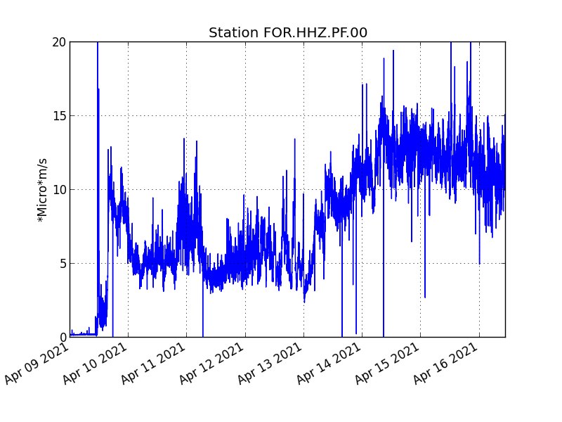
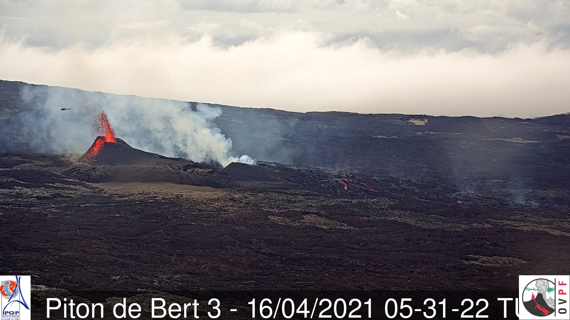
The eruption that started on 04/09/2021 at 7 p.m. (appearance of the tremor) continues. The intensity of the volcanic tremor (indicator of a surface lava emission) over the last 24 hours has remained relatively stable (Figure 1). An OVPF-IPGP mission carried out this morning with the assistance of the aerial section of the gendarmerie and the PGHM made it possible to save and recover a seismological station which was under the threat of a lava flow located about 300 m in upstream.
The flight over the eruptive site revealed:
– that the flow front located at the top of the Grandes Pentes is now frozen,
– the casting activity is now focused on the plateau downstream of the eruptive site, with the establishment of a lava tunnel regime showing numerous resurgences (Figure 3),
– the three eruptive cones are now fully enclosed laterally, only letting the lava escape through their top mouth and through tunnels (Figures 3 and 4). A merger between
two most downstream cones are occurring.
Fallout of Pélé hair was observed in the Baril sector in Saint Philippe.
Over the last 24 hours, 17 superficial volcano-tectonic earthquakes (between sea level and the surface) have been recorded under the summit craters.
The summit of the volcano still shows a low deflation (deflation), of the order of one centimeter, in connection with the emptying of the superficial magmatic reservoir located under the Dolomieu crater at 1.5-2 km depth which currently feeds the site. eruptive.
The CO2 fluxes in the soil are still increasing in the far field (Plaine des Cafres and Plaine des Palmistes) but decreasing in the near field (Gîte du volcano) since this morning. These
These parameters will have to be followed over the next few days because an increase in the far field suggests a new contribution of deep magma (mantle level).
The SO2 flows associated with the eruption and measured by the DOAS « NOVAC » network show a decrease since 04/13 which is confirmed for the day of 04/15 with an average value of 1100 tonnes / day. The associated lava flows were estimated for the day of 04/15 at an average of 6.6 m3 / sec. It should be noted that the bad weather conditions of the last few days may have affected the accuracy of the measurements but the decrease seems to be confirmed with the data of the day.
For comparison, the surface flows estimated from satellite data via the HOTVOLC platform (OPGC – Clermont Auvergne University) have recorded values between 4 and
12m3 / sec over the last 24 hours.
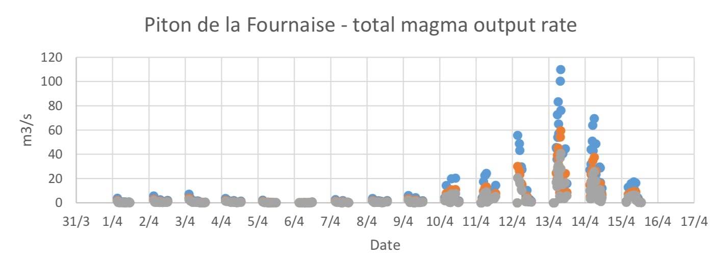
Evolution of the lava flow (in m3 / s) estimated from the degassing rate measured by DOAS spectroscopy by the NOVAC station of the OVPF-IPGP located at Piton de Bert since the start of the eruption on 04/09/2021 . The different colors correspond to the different hypotheses concerning the origin of the magma, blue: degassed superficial magma, orange: magma from the superficial reservoir, gray: deep magma rich in gas (© NOVAC network – OVPF-IPGP).
Source : OVPF.
Read the article : https://www.ipgp.fr/sites/default/files/ovpf_20210416_16h00_communique_eruption_3.pdf
Photos : OVPF.
Alaska , Semisopochnoi :
51°55’44 » N 179°35’52 » E,
Summit Elevation 2625 ft (800 m)
Current Volcano Alert Level: WARNING
Current Aviation Color Code: RED
Sustained ash emissions continue at Semisopochnoi, following low-level eruptive activity observed earlier in the week. Satellite imagery from April 12 show low-level ash emissions and new ash deposits on the east-southeast flank of the volcano extending to the coastline. Cloudy weather conditions obscured views of the volcano much of the week although explosive activity was detected occasionally by regional infrasound sensors throughout the week confirming low-level ash emissions.
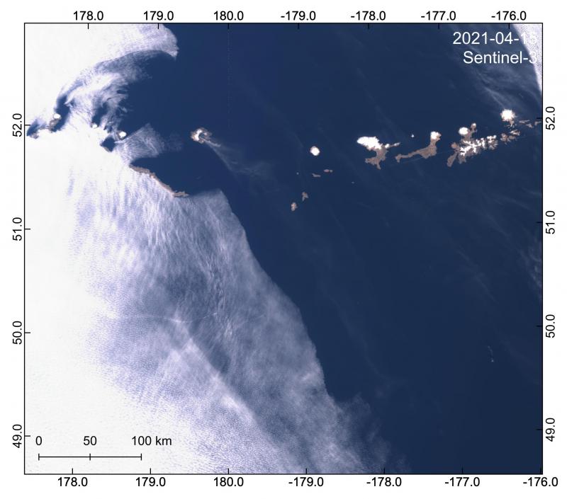
Sentinel-3 image captures an eruptive plume from Semisopochnoi volcano drifting southeast and extending >330 km from the vent.
Eruptive activity became sustained beginning the early morning of April 15, and an ash plume was visible extending more than 220 miles (350 km) southeast of the volcano with heights of 20,000 ft (6 km) above sea level. Based on the length and height of the ash plume and sustained nature of ash emissions, AVO raised the Color Code to RED and the Alert Level to WARNING on April 15. As of today sustained low-level ash emissions continue, the winds have shifted and the plume is now headed north at approximately 10,000 ft above sea level. Regional infrasound sensors detected explosions last night and early this morning. Cloudy conditions are beginning to obscure views of the volcano. AVO will continue to monitor the situation closely.
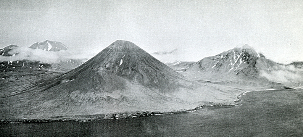
An aerial view of the SE coast of Semisopochnoi Island shows Sugarloaf peak (left-center) with a flank cone (foreground) that was the source of one of the more recent lava flows. Sugarloaf erupted outside the southern margin of an 8-km-wide caldera on Semisopochnoi. Mount Cerberus was constructed within the caldera and is on the left horizon. Pre-caldera Ragged Top is to the right.
Small eruptions producing minor ash deposits within the vicinity of the volcano are typical of activity during unrest at Semisopochnoi since September 2018. Local seismic stations have been offline since November 11, 2020. New explosions could occur at any time with no warning.
Semisopochnoi is monitored remotely by satellite and lightning detection sensors. An infrasound array on Adak Island may detect explosive emissions from Semisopochnoi with a slight delay (approximately 13 minutes) if atmospheric conditions permit.
Source : AVO.
Photos : Dietterich, Hannah , U.S. Navy .
Guatemala , Pacaya :
ACTIVITY:
The volcano remains very active, mainly with lava effusions, through the cracks of the southwest flank, forming a lava flow that reaches about 3700 meters in total length. This flow moves in various directions between the southwest, west and east flanks in places known as La Breña and La Finca Campo Alegre, Finca El Gringo, burning coffee and avocado plantations and other types of vegetation. The front of the stream is 390 meters from the first houses of the village of Patrocinio and goes ahead. Another active southern front is 385m from the village of El Rodeo, this flow obstructs the road between El Rodeo and Buena Vista. Due to this activity, it is not excluded that new lava flows and larger eruptive columns will emerge in the coming days as the level of activity remains high. The PCG seismic station records tremors (internal vibrations) associated with the rise of magma and the displacement of lava flows. The activity recorded in the Mackenney crater is maintained with weak explosions sometimes accompanied by gray ash, which the wind shifts to the east.
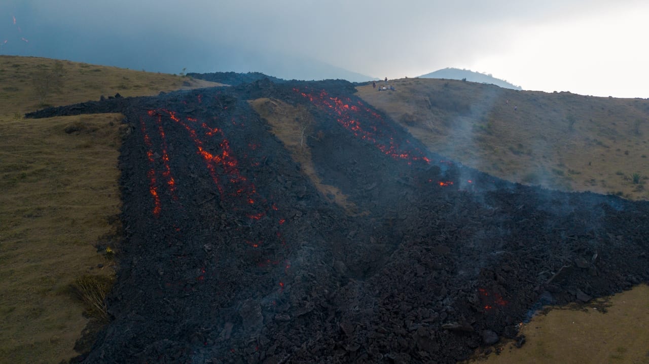
INSIVUMEH reported that the eruption at Pacaya’s Mackenney Crater continued during 7-13 April. Explosions during 6-7 April produced ash plumes that rose 1 km above the summit and drifted 10 km W and SW. Ballistics were ejected 50-150 m above the summit. Explosions during 8-9 and 11-12 April produced ash plumes that rose as high as 1 km and drifted as far as 10 km NE, W, and SW.
The lava flow on the W and SW flanks was 3.7 km long and continued to be fed. Incandescent lava blocks were spalled from the flow front and vegetation was set on fire. The lava advanced W onto the La Breña farm and SW towards El Patrocinio and El Rodeo, near the Campo Alegre farm. On 12 April the flows burned La Breña coffee and avocado plantations. By 13 April the lava flows were 3.8 km long, and within 370 m of houses in El Patrocinio. Another flow front was 250 m E of El Rodeo, and obstructed the road that connects El Rodeo, El Caracol, and Los Pocitos.
Source : Insivumeh
Photo : Conred .