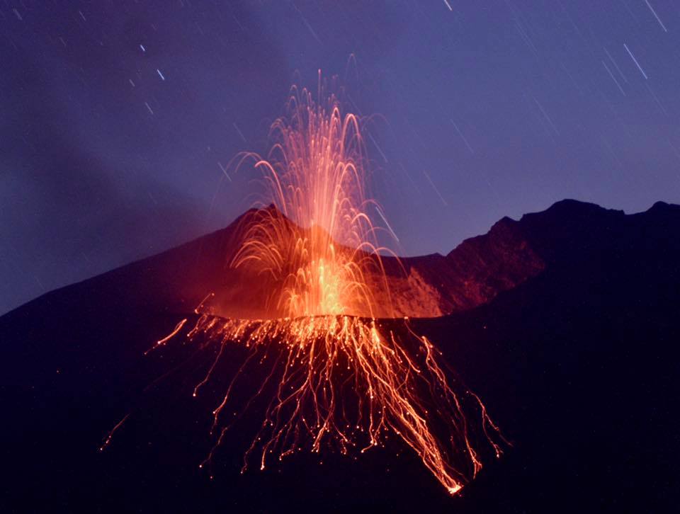
July 25, 2022. EN. Japan : Sakurajima , Iceland : Bárðarbunga , Italy : Stromboli , Indonesia : Semeru , Ecuador : Sangay .

July 25 , 2022.


Japan , Sakurajima :

The Japanese Meteorological Agency decreed this Sunday the maximum alert level and the mandatory and immediate evacuation of populations near the Sakurajima volcano, which erupted this afternoon. The agency calls on people within 3 kilometers of the Minamidake crater to watch out for flying large boulders. The area includes part of Arimura and Furusato districts in Kagoshima City.

Authorities decided to declare alert level 5, the highest, after warning that the volcano was expelling volcanic stones at a distance of three kilometers, according to Japanese public broadcaster NHK.
According to the television channel, the explosion occurred at 8:05 p.m. this Sunday and the column of ash and water vapor dispersed about 2.5 km from the crater.

The authorities called on the population to be careful with pyroclastic flows within a radius of about 2 kilometers around the crater. Since Monday, the agency has observed minor crustal movements indicating expansion of the volcano.

This is the first Level 5 alert since the Kagoshima volcanic eruption in 2015 and the second since the Alert Level was introduced in 2007.

According to the Japan Meteorological Agency, a large-scale eruption affecting a large area of the island is not imminent.
The volcano entered the eruptive phase on July 17 and since then its level of activity has increased.

Source : aristeguinoticias.com.

Photo : k. Arima ( archive) .


Iceland , Bárðarbunga :

At 13:23, an earthquake of magnitude M4.4 occurred in the northern rim of Bárðarbunga’s caldera. At 13:45 an earthquake of magnitude M4.9 occurred in the same area. A few aftershocks have been detected and no volcanic tremor is visible.


The SIL network measured 619 earthquakes in and around Iceland in week 28 and have all events been manually refined. This is a similar number as was recorded the week before. Two earthquakes above magnitude 3 were recorded some 2 km NE of Sýrfell on the Reykjanes Peninsula; 3.4 and 3.3, both the morning of the 12th of July. The Iceland Met Office received one notification that the earthquake had been felt in Reykjanesbær. In Hekla volcano 6 small earthquakes were recorded and 26 earthquakes in the Katla caldera, all smaller than 2.5 in magnitude.

Source et photo : Vedur is.


Italy , Stromboli :

PRESS RELEASE ON STROMBOLI ACTIVITY, July 29, 2022, 03:54 (01:54 UTC).

The National Institute of Geophysics and Volcanology, Osservatorio Etneo, announces that at 00:57 (UTC) the seismic stations of Stromboli recorded a low frequency signal which evolved in a few seconds, showing the characteristics of the associated waveforms to landslides. After about 3 minutes, the phenomenon ends.
The HF GNSS network shows no significant changes. The inclinometer network is not currently available.
Due to cloud cover, it was not possible to observe the phenomenon from surveillance cameras.

PRESS RELEASE ON STROMBOLI ACTIVITY, July 29, 2022, 06:17 (04:17 UTC).

The National Institute of Geophysics and Volcanology, Osservatorio Etneo announces that CCTV camera analysis, starting at 02:56 UTC, recorded a series of explosions from the North Crater area, the strongest of which was is produced at 02:56:30 UTC. The material produced fell abundantly along the entire Sciara del Fuoco, while there was no significant fallout of coarse material in the Pizzo area. After the more intense initial explosive phase, Strombolian activity continues at the N2 vent of the North Crater area, with frequent low-intensity explosions.
The seismic signal after the maximum amplitude values ​​reached at 2:56 UTC showed a rapid decrease reaching at 3:40 am values ​​similar to those before the explosion.
The tilt sensor array shows a modest pulse variation (about 0.05 mrad) in the N275E component of the TDF (Timpone del Fuoco) station at 2:55 a.m. No significant change in the high frequency GNSS network.

Further updates will be communicated promptly and in any case within 3 hours of this press release.

Source : INGV.

Photo : Stromboli Stati D’animo.


Indonesia , Semeru :

VOLCANO OBSERVATORY NOTICE FOR AVIATION – VONA

Issued : July 24 , 2022
Volcano : Semeru (263300)
Current Aviation Colour Code : ORANGE
Previous Aviation Colour Code : orange
Source : Semeru Volcano Observatory
Notice Number : 2022SMR174
Volcano Location : S 08 deg 06 min 29 sec E 112 deg 55 min 12 sec
Area : East java, Indonesia
Summit Elevation : 11763 FT (3676 M)

Volcanic Activity Summary :
Eruption with volcanic ash cloud at 07h55 UTC (14h55 local). Eruption and ash emission is continuing.

Volcanic Cloud Height :
Best estimate of ash-cloud top is around 12723 FT (3976 M) above sea level, may be higher than what can be observed clearly. Source of height data: ground observer.

Other Volcanic Cloud Information :
Ash-cloud moving to southwest

SEISMICITY OBSERVATION:
16 earthquakes of eruptions/explosions with an amplitude of 11-25 mm and a duration of 55-140 seconds.
1 emission earthquake with an amplitude of 7 mm and a duration of 55 seconds.
1 Harmonic tremor with an amplitude of 3 mm, and a duration of 60 seconds.

Source : Magma Indonésie.

Photo : PVMBG ( archive).


Ecuador , Sangay :

Information on the activity of the SANGAY volcano Nº 2022-059, Quito, Sunday July 24, 2022.

From approximately 6:10 p.m. TL using satellite images (GOES-16), as well as an alert from the Washington VAAC at 6:50 p.m. TL, a thin column of ash can be observed heading southwest. Therefore, there is a slight possibility of ash fall in areas surrounding the volcano in this direction. The IG-EPN continues to monitor the event and will inform in a timely manner if any relevant changes are detected.

GOES-16 satellite image.


The Geophysical Institute is monitoring and any news will be reported.

DAILY REPORT OF THE STATE OF SANGAY VOLCANO, Sunday July 24, 2022.
Information Geophysical Institute – EPN.

Surface Activity Level: High, Surface Trend: No change.
Internal activity level: High, Internal trend: No change.

Seismicity: From July 23, 2022, 11:00 a.m. to July 24, 2022, 11:00 a.m.:

Due to technical problems in the reference station, the counting of seismic events was carried out in about 7 signal hours.
Explosions (EXP) 83
Long Periods (LP)34
Emission Tremors (TREMI ) 6.


Rains / Lahars:
No rain was recorded in the area. **In the event of heavy rains, these could remobilize the accumulated materials, generating mudslides and debris that would descend on the flanks of the volcano and flow into the adjacent rivers.**

Emission / ash column:
Thanks to the cameras, no emission was observed, however, the VAAC recorded 4 ash emission alerts observed on satellites which bordered heights of 1200 meters above the level of the crater in a South-West direction.

Other Monitoring Parameters:
The FIRMS system reported 1 thermal anomaly on the Sangay in the last 24 hours.

Observation:
Weather conditions in the area prevented direct observations of surface activity. Until the publication of this bulletin, there are no reports of ashfall.

Alert level: Orange.

Source : IGEPN.

Photos : IGEPN , Robinski via Marina Morozova

25 Juillet 2022. FR. Japon : Sakurajima , Islande : Bárðarbunga , Italie : Stromboli , Indonésie : Semeru , Equateur : Sangay .

25 Juillet 2022.


Japon , Sakurajima :

L’Agence météorologique japonaise a décrété ce dimanche le niveau d’alerte maximal et l’évacuation obligatoire et immédiate des populations à proximité du volcan Sakurajima , entré en éruption cet après-midi. L’agence appelle les personnes à moins de 3 kilomètres du cratère Minamidake à faire attention aux projections de gros rochers. La zone comprend une partie des districts d’Arimura et de Furusato dans la ville de Kagoshima.

Les autorités ont décidé de déclarer le niveau d’alerte 5, le plus élevé, après avoir averti que le volcan expulsait des pierres volcaniques à une distance de trois kilomètres, selon la chaîne publique japonaise NHK.
Selon la chaîne de télévision, l’explosion s’est produite à 20h05 ce dimanche et la colonne de cendres et de vapeur d’eau s’est dispersée à environ 2,5 km du cratère.

Les autorités ont appelé la population à être prudente avec les coulées pyroclastiques dans un rayon d’environ 2 kilomètres autour du cratère. Depuis lundi, l’agence a observé des mouvements mineurs de la croûte indiquant une expansion du volcan.

Il s’agit de la première alerte de niveau 5 depuis l’éruption volcanique de Kagoshima en 2015 et la deuxième depuis l’introduction de ce niveau d’alerte en 2007.

Selon l’Agence météorologique japonaise, une éruption à grande échelle affectant une vaste zone de l’île n’est pas imminente.
Le volcan est entré en phase éruptive le 17 juillet et depuis lors, son niveau d’activité a augmenté.

Source : aristeguinoticias.com.

Photo : k. Arima ( archive) .


Islande , Bárðarbunga :

À 13 h 23 hier, un tremblement de terre de magnitude M4,4 s’est produit sur le bord Nord de la caldeira du Bárðarbunga. A 13h45 un tremblement de terre de magnitude M4.9 s’est produit dans la même zone. Quelques répliques ont été détectées et aucun tremor volcanique n’est visible.
 

Le réseau SIL a mesuré 619 tremblements de terre sous et autour de l’Islande au cours de la semaine 28 et tous les événements ont été affinés manuellement. Il s’agit d’un nombre similaire à celui enregistré la semaine précédente. Deux séismes de magnitude supérieure à 3 ont été enregistrés à environ 2 km au Nord-Est de Sýrfell sur la péninsule de Reykjanes ; 3.4 et 3.3, tous deux le matin du 12 juillet. Le Met Office islandais a reçu une notification indiquant que le tremblement de terre avait été ressenti à Reykjanesbær. Sur le volcan Hekla, 6 petits tremblements de terre ont été enregistrés et 26 tremblements de terre dans la caldeira du Katla, tous d’une magnitude inférieure à 2,5.

Source et photo : Vedur is.


Italie , Stromboli :

COMMUNIQUÉ DE PRESSE SUR L’ACTIVITE DE STROMBOLI , 29 Juillet 2022, 03:54 (01:54 UTC) .

L’Institut National de Géophysique et de Volcanologie, Osservatorio Etneo , annonce qu’à 00:57 (UTC) les stations sismiques de Stromboli ont enregistré un signal basse fréquence qui a évolué en quelques secondes , montrant les caractéristiques des formes d’onde associées aux glissements de terrain. Après environ 3 minutes, le phénomène se termine.
Le réseau HF GNSS ne montre pas de changements significatifs. Le réseau inclinométrique n’est pas disponible actuellement.
En raison de la couverture nuageuse, il n’a pas été possible d’observer le phénomène à partir des caméras de surveillance.

COMMUNIQUÉ DE PRESSE SUR L’ACTIVITE DE STROMBOLI , 29 Juillet 2022, 06:17 (04:17 UTC) .

L’Institut national de géophysique et de volcanologie, Osservatorio Etneo  annonce que l’analyse des caméras de vidéosurveillance, à partir de 02:56 UTC, a enregistré une série d’explosions depuis la zone du cratère Nord, dont la plus forte s’est produite à 02:56:30 UTC. Le matériau produit est retombé abondamment le long de toute la Sciara del Fuoco, alors qu’il n’y a pas eu de retombées significatives de matériau grossier dans la zone du Pizzo. Après la phase explosive initiale plus intense, l’activité strombolienne se poursuit au niveau de l’évent N2 de la zone du cratère Nord, avec de fréquentes explosions de faible intensité.
Le signal sismique après les valeurs maximales d’amplitude atteintes à 2h56 UTC a montré une décroissance rapide atteignant à 3h40 des valeurs similaires à celles d’avant l’explosion.
Le réseau de capteurs d’inclinaison montre une variation d’impulsion modeste (environ 0,05 mrad) dans la composante N275E de la station TDF (Timpone del Fuoco) à 2h55. Aucun changement significatif dans le réseau GNSS haute fréquence.

D’autres mises à jour seront communiquées rapidement et dans tous les cas dans les 3 heures suivant ce communiqué de presse.

Source : INGV.

Photo : Stromboli Stati D’animo.


Indonésie , Semeru :

AVIS D’OBSERVATION DU VOLCAN POUR L’AVIATION – VONA

Émis : 24 juillet 2022
Volcan : Semeru (263300)
Code Couleur Aviation Actuel : ORANGE
Code Couleur Aviation précédent : orange
Source : Observatoire du volcan Semeru
Numéro d’avis : 2022SMR174
Emplacement du volcan : S 08 deg 06 min 29 sec E 112 deg 55 min 12 sec
Région : Java oriental, Indonésie
Altitude du sommet : 11763 FT (3676 M)

Résumé de l’activité volcanique :
Eruption avec nuage de cendres volcaniques à 07h55 UTC (14h55 locale). L’éruption et l’émission de cendres se poursuivent.

Hauteur des nuages volcaniques :
La meilleure estimation du sommet du nuage de cendres est d’environ 12723 FT (3976 M) au-dessus du niveau de la mer, peut être plus élevée que ce qui peut être observé clairement. Source des données de hauteur : observateur au sol.

Autres informations sur les nuages volcaniques :
Nuage de cendres se déplaçant vers le Sud-Ouest

OBSERVATION DE LA SISMICITE:
16 tremblements de terre d’éruptions/explosions avec une amplitude de 11-25 mm et une durée de 55-140 secondes.
1 séisme de d’émission d’une amplitude de 7 mm et d’une durée de 55 secondes.
1 tremor Harmonique avec une amplitude de 3 mm, et une durée de 60 secondes.

Source : Magma Indonésie.

Photo : PVMBG ( archive).


Equateur , Sangay :

Information sur l’activité du volcan SANGAY Nº 2022-059, Quito, Dimanche 24 juillet 2022.

À partir d’environ 18h10 TL grâce à des images satellites (GOES-16), ainsi qu’une alerte du VAAC de Washington à 18h50 TL, une fine colonne de cendres peut être observée se dirigeant vers le Sud-Ouest. Par conséquent, il existe une légère possibilité de chute de cendres dans les zones entourant le volcan dans cette direction. L’IG-EPN continue de surveiller l’événement et informera en temps opportun si des changements pertinents sont détectés.

Image satellite GOES-16. 


L’Institut géophysique surveille et toute nouvelle sera rapportée.

RAPPORT QUOTIDIEN DE L’ETAT DU VOLCAN SANGAY , Dimanche 24 Juillet 2022.
Information Geophysical Institute – EPN.

Niveau d’activité Superficiel: Haut , Tendance de surface : Pas de changement .
Niveau d’activité interne: Haut , Tendance interne : Pas de changement .

Sismicité : Du 23 Juillet 2022 , 11:00h au 24 Juillet 2022 , 11:00h : 

En raison de problèmes techniques dans la station de référence, le comptage des événements sismiques a été effectué en environ 7 heures de signal..
Explosion (EXP) 83
Longues périodes (LP)34
Tremors d’émissions (TREMI ) 6.


Pluies / Lahars :
Aucune pluie n’a été enregistrée dans le secteur. **En cas de fortes pluies, celles-ci pourraient remobiliser les matériaux accumulés, générant des coulées de boue et de débris qui descendraient sur les flancs du volcan et se déverseraient dans les rivières adjacentes.**

Émission / colonne de cendres :
Grâce aux caméras, aucune émission n’a été observée, cependant, le VAAC a enregistré 4 alertes d’émission de cendres observées sur des satellites qui bordaient des hauteurs de 1200 mètres au-dessus du niveau du cratère dans une direction Sud-Ouest.

Autres paramètres de surveillance :
Le système FIRMS a signalé 1 anomalie thermique sur le Sangay au cours des dernières 24 heures.

Observation:
Les conditions météorologiques dans le secteur ont empêché les observations directes de l’activité de surface. Jusqu’à la publication de ce bulletin, il n’y a aucun rapport de chute de cendres.

Niveau d’alerte: Orange.

Source : IGEPN.

Photos : IGEPN , Robinski via Marina Morozova