July 25 , 2022.
Japan , Sakurajima :
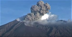
The Japanese Meteorological Agency decreed this Sunday the maximum alert level and the mandatory and immediate evacuation of populations near the Sakurajima volcano, which erupted this afternoon. The agency calls on people within 3 kilometers of the Minamidake crater to watch out for flying large boulders. The area includes part of Arimura and Furusato districts in Kagoshima City.
Authorities decided to declare alert level 5, the highest, after warning that the volcano was expelling volcanic stones at a distance of three kilometers, according to Japanese public broadcaster NHK.
According to the television channel, the explosion occurred at 8:05 p.m. this Sunday and the column of ash and water vapor dispersed about 2.5 km from the crater.
The authorities called on the population to be careful with pyroclastic flows within a radius of about 2 kilometers around the crater. Since Monday, the agency has observed minor crustal movements indicating expansion of the volcano.
This is the first Level 5 alert since the Kagoshima volcanic eruption in 2015 and the second since the Alert Level was introduced in 2007.
According to the Japan Meteorological Agency, a large-scale eruption affecting a large area of the island is not imminent.
The volcano entered the eruptive phase on July 17 and since then its level of activity has increased.
Source : aristeguinoticias.com.
Photo : k. Arima ( archive) .
Iceland , Bárðarbunga :
At 13:23, an earthquake of magnitude M4.4 occurred in the northern rim of Bárðarbunga’s caldera. At 13:45 an earthquake of magnitude M4.9 occurred in the same area. A few aftershocks have been detected and no volcanic tremor is visible.
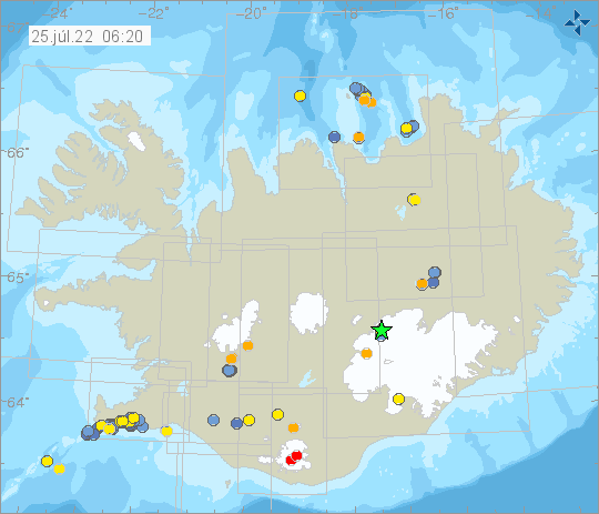
The SIL network measured 619 earthquakes in and around Iceland in week 28 and have all events been manually refined. This is a similar number as was recorded the week before. Two earthquakes above magnitude 3 were recorded some 2 km NE of Sýrfell on the Reykjanes Peninsula; 3.4 and 3.3, both the morning of the 12th of July. The Iceland Met Office received one notification that the earthquake had been felt in Reykjanesbær. In Hekla volcano 6 small earthquakes were recorded and 26 earthquakes in the Katla caldera, all smaller than 2.5 in magnitude.
Source et photo : Vedur is.
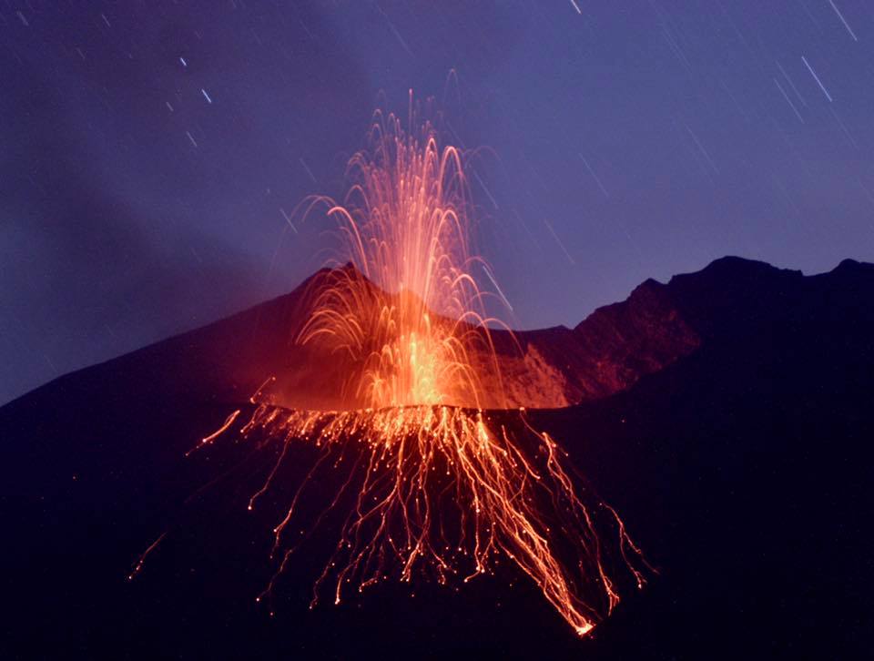
Italy , Stromboli :
PRESS RELEASE ON STROMBOLI ACTIVITY, July 29, 2022, 03:54 (01:54 UTC).
The National Institute of Geophysics and Volcanology, Osservatorio Etneo, announces that at 00:57 (UTC) the seismic stations of Stromboli recorded a low frequency signal which evolved in a few seconds, showing the characteristics of the associated waveforms to landslides. After about 3 minutes, the phenomenon ends.
The HF GNSS network shows no significant changes. The inclinometer network is not currently available.
Due to cloud cover, it was not possible to observe the phenomenon from surveillance cameras.
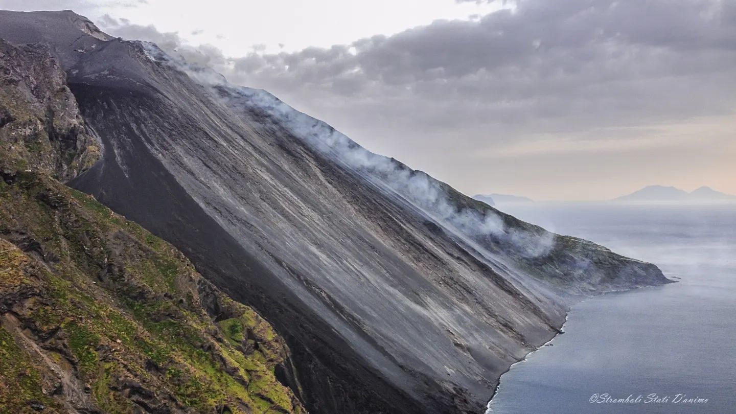
PRESS RELEASE ON STROMBOLI ACTIVITY, July 29, 2022, 06:17 (04:17 UTC).
The National Institute of Geophysics and Volcanology, Osservatorio Etneo announces that CCTV camera analysis, starting at 02:56 UTC, recorded a series of explosions from the North Crater area, the strongest of which was is produced at 02:56:30 UTC. The material produced fell abundantly along the entire Sciara del Fuoco, while there was no significant fallout of coarse material in the Pizzo area. After the more intense initial explosive phase, Strombolian activity continues at the N2 vent of the North Crater area, with frequent low-intensity explosions.
The seismic signal after the maximum amplitude values reached at 2:56 UTC showed a rapid decrease reaching at 3:40 am values similar to those before the explosion.
The tilt sensor array shows a modest pulse variation (about 0.05 mrad) in the N275E component of the TDF (Timpone del Fuoco) station at 2:55 a.m. No significant change in the high frequency GNSS network.
Further updates will be communicated promptly and in any case within 3 hours of this press release.
Source : INGV.
Photo : Stromboli Stati D’animo.
Indonesia , Semeru :
VOLCANO OBSERVATORY NOTICE FOR AVIATION – VONA
Issued : July 24 , 2022
Volcano : Semeru (263300)
Current Aviation Colour Code : ORANGE
Previous Aviation Colour Code : orange
Source : Semeru Volcano Observatory
Notice Number : 2022SMR174
Volcano Location : S 08 deg 06 min 29 sec E 112 deg 55 min 12 sec
Area : East java, Indonesia
Summit Elevation : 11763 FT (3676 M)
Volcanic Activity Summary :
Eruption with volcanic ash cloud at 07h55 UTC (14h55 local). Eruption and ash emission is continuing.

Volcanic Cloud Height :
Best estimate of ash-cloud top is around 12723 FT (3976 M) above sea level, may be higher than what can be observed clearly. Source of height data: ground observer.
Other Volcanic Cloud Information :
Ash-cloud moving to southwest
SEISMICITY OBSERVATION:
16 earthquakes of eruptions/explosions with an amplitude of 11-25 mm and a duration of 55-140 seconds.
1 emission earthquake with an amplitude of 7 mm and a duration of 55 seconds.
1 Harmonic tremor with an amplitude of 3 mm, and a duration of 60 seconds.
Source : Magma Indonésie.
Photo : PVMBG ( archive).
Ecuador , Sangay :
Information on the activity of the SANGAY volcano Nº 2022-059, Quito, Sunday July 24, 2022.
From approximately 6:10 p.m. TL using satellite images (GOES-16), as well as an alert from the Washington VAAC at 6:50 p.m. TL, a thin column of ash can be observed heading southwest. Therefore, there is a slight possibility of ash fall in areas surrounding the volcano in this direction. The IG-EPN continues to monitor the event and will inform in a timely manner if any relevant changes are detected.
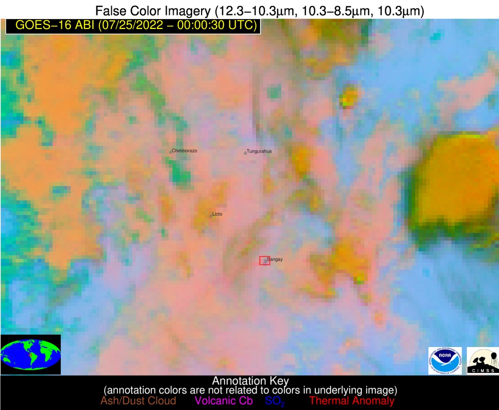
GOES-16 satellite image.
The Geophysical Institute is monitoring and any news will be reported.
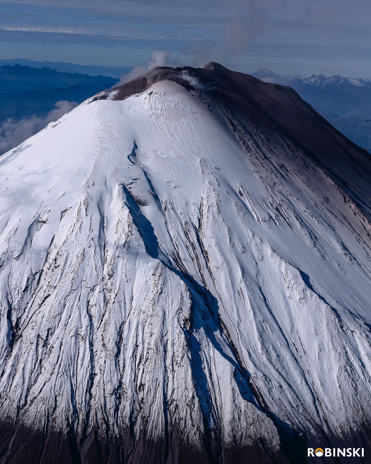
DAILY REPORT OF THE STATE OF SANGAY VOLCANO, Sunday July 24, 2022.
Information Geophysical Institute – EPN.
Surface Activity Level: High, Surface Trend: No change.
Internal activity level: High, Internal trend: No change.
Seismicity: From July 23, 2022, 11:00 a.m. to July 24, 2022, 11:00 a.m.:
Due to technical problems in the reference station, the counting of seismic events was carried out in about 7 signal hours.
Explosions (EXP) 83
Long Periods (LP)34
Emission Tremors (TREMI ) 6.
Rains / Lahars:
No rain was recorded in the area. **In the event of heavy rains, these could remobilize the accumulated materials, generating mudslides and debris that would descend on the flanks of the volcano and flow into the adjacent rivers.**
Emission / ash column:
Thanks to the cameras, no emission was observed, however, the VAAC recorded 4 ash emission alerts observed on satellites which bordered heights of 1200 meters above the level of the crater in a South-West direction.
Other Monitoring Parameters:
The FIRMS system reported 1 thermal anomaly on the Sangay in the last 24 hours.
Observation:
Weather conditions in the area prevented direct observations of surface activity. Until the publication of this bulletin, there are no reports of ashfall.
Alert level: Orange.
Source : IGEPN.
Photos : IGEPN , Robinski via Marina Morozova