February 22 , 2024.
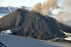
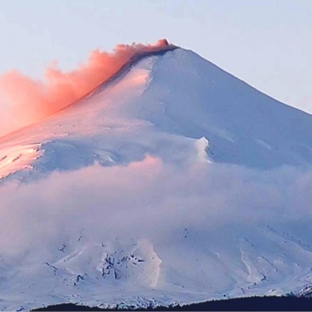
Japan , Sakurajima :
JMA reported ongoing eruptive activity at Minamidake Crater (Aira Caldera’s Sakurajima volcano) during 12-19 February with nighttime crater incandescence. Sulfur dioxide emissions averaged 1,400 tons per day on 20 December. An explosion at 06h59 on 14 February generated an ash plume that rose 2 km above the crater rim and drifted N, and ejected blocks 300-500 m away from the vent. A larger explosion at 18h33 on 14 February produced an ash plume that rose as high as 5 km above the summit that drifted E and NE and ejected large blocks as far as 1.3 km from the vent. Ash plumes had not risen that high since an explosion at 05h38 on 9 August 2020.

A large amount of ashfall completely covered roadways in some parts of the N part of the island based on 15 February field observations. Residents reported ashfall in Kagoshima, Aira, Kirishima, Kanoya, Soo, and parts of Miyazaki Prefecture. Eruptive events at 22h20 on 16 February, and 15h23, 15h56, 16h31, and 23h59 on 17 February, generated ash plumes that rose 1-1.3 km above the summit and drifted E and SE. The Alert Level remained at 3 (on a 5-level scale), and the public was warned to stay 2 km away from both craters.
Sources : Japan Meteorological Agency (JMA) , GVP.
Photo : Capture webcam
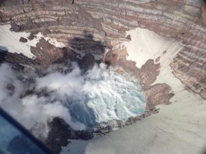
Pérou , Misti :
The Instituto Geofísico del Perú (IGP) reported that a lahar descended from the southeastern flank of El Misti at 7:05 p.m. on February 20. The public has been warned to stay away from pipes and roads on this flank.
Local date and time: February 20, 2024 – 7:05 p.m.
Location: Southeast sector of the Misti volcano
Type of event: Lahar (Flow of volcanic origin)
Areas of possible impact: Chiguata District (right bank of the Andamayo River, Agua Salada ravine).
REMARKS :
The flow is a cold mixture of water and volcanic sediments (ash, blocks, etc.).
RECOMMENDATIONS:
The flow crosses the southeast sector of the Misti volcano (outskirts of the city of Arequipa). It is therefore recommended: a) To the population: Stay away from the watercourses located on this side of the volcano and avoid driving on the nearby roads during this period. b) To the authorities: Carry out an assessment of the impact of the flow in localities and areas close to the stream bed, as well as on roads and irrigation infrastructure (reservoirs and water canals).
Source : GVP , IGP.
Photo : Auteur inconnu
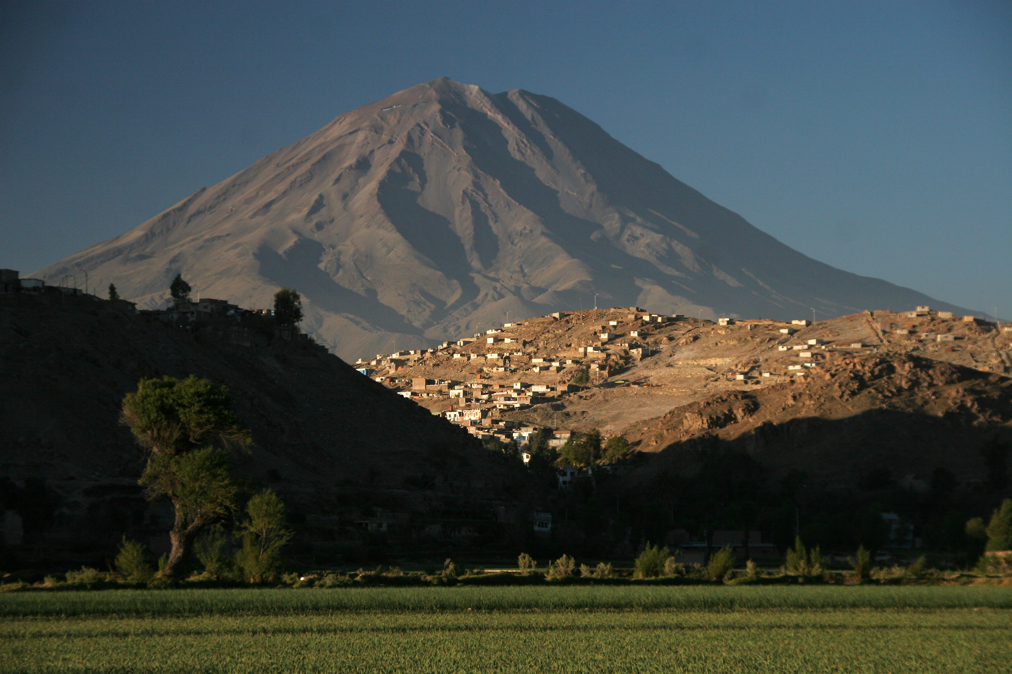
Mexico , Popocatepetl :
February 21, 11:00 a.m. (February 21, 5:00 p.m. GMT). Activity from the last 24 hours
67 exhalations were detected, in addition 918 minutes of high frequency and low to very low amplitude tremors were identified; Both volcanic events were accompanied by water vapor, other gases and ash.
During this period, the National Center for Communications and Civil Protection Operations (Cenacom) reported light ash falls in the municipalities of Hueyapan, Tetela del Volcano and Jiutepec, in Morelos.
During the morning and at the time of this report, a continuous emission of light ash, water vapor and volcanic gases is observed, with an initial dispersion towards the South-West turning towards the North-North-East.
The Popocatépetl volcanic warning fire is in yellow phase 2.
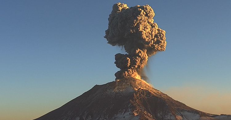
CENAPRED reported that eruptive activity continued at Popocatépetl during 14-20 February. Long-period events totaling 9-330 per day were accompanied by steam-and-gas plumes that occasionally contained minor amounts of ash. The seismic network recorded from 9 to almost 24 hours of daily tremor, often characterized as high frequency and low amplitude. The Washington VAAC reported that daily ash plumes visible in webcam and/or satellite images rose to km (19,000-20,000 ft) a.s.l. and drifted N, NE, SSE, and S. Based on information from El Centro Nacional de Comunicación y Operación de Protección Civil (CENACOM), CENAPRED noted that at 08h30 on 14 February minor amounts of ashfall was reported in the municipalities of Nativitas (40 km NE), Santa Isabel (45 km ESE), Tetlatlahuaca (42 km NE), Tlaxcala (51 km NE), Santa Ana Chiautempan, and Zacatelco (45 km NE). Additionally, the Hermanos Serdán International Airport, located 30 km NE in the municipality of Huejotzingo, was closed during 08h00-13h00 so that ashfall could be cleared from the runway. Later that afternoon ashfall was reported in Puebla (43 km E). Minor ashfall was reported in the municipality of Hueyapan (17 km SSW) at 20h25 on 19 February. The Alert Level remained at Yellow, Phase Two (the middle level on a three-color scale) and the public was warned to stay 12 km away from the crater.
Sources : Centro Nacional de Prevencion de Desastres (CENAPRED), Washington Volcanic Ash Advisory Center (VAAC) , GVP.
Photo : Cenapred
Chile , Villarica :
Special Report on Volcanic Activity (REAV), La Araucanía and Los Ríos regions, Villarrica volcano, February 21, 2024, 1:20 p.m. local time (mainland Chile)
The National Geology and Mining Service of Chile (Sernageomin) announces the following PRELIMINARY information, obtained through the monitoring equipment of the National Volcanic Monitoring Network (RNVV), processed and analyzed at the Southern Andean Volcano Observatory (Ovdas):
On Wednesday February 21, 2024, at 12:35 p.m. local time (3:35 p.m. UTC), monitoring stations installed near the Villarrica volcano recorded an earthquake associated with the fracturing of rocks inside the volcanic system (volcano-tectonic type).
The characteristics of this earthquake after its analysis are as follows:
ORIGINAL TIME: 12:35 local time (3:35 UTC)
LATITUDE: 39.413°S
LONGITUDE: 71.918°W
DEPTH: 4.8 km
LOCAL MAGNITUDE: 3 (ML)
Observation :
The difficult weather conditions in the area did not allow the observation of surface activity. At the time of issuing this report, no changes in the monitoring parameters have been recorded.
The technical volcanic alert is maintained at YELLOW level.
SERNAGEOMIN reported that the eruption at Villarrica continued during 12-20 February. At 19h37 on 12 February a long-period (LP) earthquake associated with fluid movement was accompanied by a gas emission with minor ash content that rose 420 m above the vent and drifted SW. LP earthquakes at 22h06 on 13 February and 01h53 on 14 February were accompanied by Strombolian explosions that ejected material 40-60 m high. The ejected material fell back into the crater. LP events were recorded at 07h40 on 15 February and 02h28 on 17 February, though no emissions were visible on the 15th and weather conditions prevented visual observations on the 17th. The Volcanic Alert level remained at Yellow (the second lowest level on a four-level scale) and the public was warned to stay 1 km away from the active crater.
Sources : Sernageomin , GVP
Photo : Nelson Rojas.
Colombia , Puracé – Los Coconucos volcanic chain. :
Weekly bulletin of the activity of the Puracé volcano – Los Coconucos volcanic chain
From the monitoring of the activity of the PURACE VOLCANO – LOS COCONUCOS VOLCANIC CHAIN , the MINISTRY OF MINES AND ENERGY, through the COLOMBIAN GEOLOGICAL SERVICE (SGC), reports that:
During the week of February 13 to 19, 2024, seismic activity presented levels comparable to those of the previous week, both in energy and in number of events. The fracture earthquakes were located mainly under the Puracé volcano, with depths less than 5 km and magnitudes less than 1.0 ML; while the earthquakes associated with the fluids were located in two areas, one under the crater of the volcano with depths less than 1 km and another to the South-East of it at depths between 1.5 and 5 km.
Likewise, localized deformations continued to be recorded between the Puracé and Curiquinga volcanoes. Carbon dioxide (CO2) values continue to oscillate and remain above reference values on this volcano. On the other hand, stable values were recorded in the sulfur dioxide (SO2) flux.
Images obtained using installed cameras show that significant degassing of the volcanic system continues.
The other parameters measured and used for the diagnosis of volcanic activity showed no notable changes during the period evaluated.
The alert status for volcanic activity remains at: YELLOW ALERT: ACTIVE VOLCANO WITH CHANGES IN THE BEHAVIOR OF THE BASE LEVEL OF MONITORED PARAMETERS AND OTHER MANIFESTATIONS.
Source et photo : SGC