August 18 , 2021 .
Italy , Stromboli :
Weekly Bulletin from August 09, 2021 to August 15, 2021 (issue date August 17, 2021)
SUMMARY STATEMENT OF ACTIVITY
In view of the monitoring data, it is highlighted:
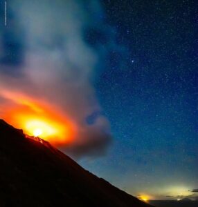
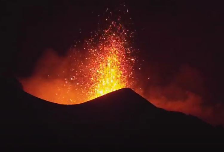
1) VOLCANOLOGICAL OBSERVATIONS: During this period a normal explosive activity of strombolian type was observed. The total hourly frequency of explosions fluctuated between medium-low and medium values (8-11 events / h). The intensity of the explosions was mainly medium-low in the North crater area and medium-high in the Center-South crater area.
2) SEISMOLOGY: The seismological parameters monitored do not show significant variations.
3) DEFORMATIONS: The island’s soil deformation monitoring networks did not show any significant changes to report for the period under observation.
4) GEOCHEMISTRY: SO2 flux at a medium-low level.
The flow of CO2 from the ground to the Pizzo Sopra la Fossa does not show any significant changes compared to previous weeks, remaining at average values.
The average weekly C / S value is 9.6 and is at average values. Last measurement recorded on 07/28/2021.
The isotopic ratio of Helium dissolved in the thermal aquifer compared to the last sampling of 07/27/2021 is at medium – high values.
5) SATELLITE OBSERVATIONS: The thermal activity in the summit area is low to moderate.
VOLCANOLOGICAL OBSERVATIONS
During the observation period, the eruptive activity of Stromboli was characterized thanks to the analysis of the images recorded by the surveillance cameras of the INGV-OE (altitude 190m, Punta dei Corvi, altitude 400m and Pizzo). The explosive activity was mainly produced by 3 (three) eruptive chimneys located in the area of the North crater and by 6 (six) eruptive chimneys located in the area of the Center-South crater. All the vents are placed inside the depression which occupies the terrace of the crater.
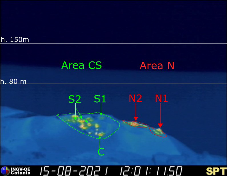
Fig. 3.1 – The crater terrace seen by the thermal camera placed on the Pizzo sopra la Fossa with the delimitation of the zones of the crater Center-South Zone and North Zone (ZONE N, ZONE C-S respectively). Abbreviations and arrows indicate the names and locations of active vents, the area above the crater terrace is divided into three height ranges relating to the intensity of the explosions.
The N1 crater located in the North zone, with two emission points, produced explosions of medium-low intensity (the products of some explosions reached 150 m in height) emitting coarse materials (lapilli and bombs) which fell profusely with a radial distribution.
During the period, the growth of a hornitos was observed from which most of the explosions consisting of jets, perpendicular to sector N1, emitting coarse materials were produced. Vent N2 showed low intensity explosive activity (less than 80 m in height) emitting fine material sometimes mixed with coarse material. The average frequency of explosions varied from 4 to 6 events / h.
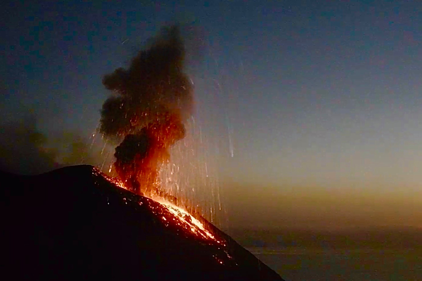
In the Center-South zone, the S1 vent, located on the cone facing the Sciara del Fuoco, produced low-intensity explosions emitting fine materials, sometimes mixed with coarse materials, while the three vents located in Sector S2 produced medium to high intensity explosions, emitting fine material mixed with coarse coarse material. Sector C produced intense puffs and sometimes intense degassing activity. The frequency of the explosions was between 4 and 6 events / h.
Source : INGV.
Photos : ilvulcanoapiedi , webcam
Italy / Sicily , Etna :
Weekly Bulletin from August 09, 2021 to August 15, 2021 (issue date August 17, 2021)
SUMMARY STATEMENT OF ACTIVITY:
In view of the monitoring data, it is highlighted:
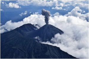
1) VOLCANOLOGICAL OBSERVATIONS: Strombolian activity with a lava fountain episode at the Southeast Crater; discontinuous ash emissions at the Northeast Crater; ordinary degassing of other summit craters.
2) SEISMOLOGY: Seismic activity of weak fracturing. Amplitude of the volcanic tremor on the medium-low level. Large and sudden fluctuations up to high values can be correlated with the explosive activity of the Southeast Crater.
3) INFRASONO: Moderate infrasound activity.
4) DEFORMATIONS: During the last week there have been no significant changes after the lava fountain event of August 9 already included in the previous weekly bulletin (rep. 32/2021).
5) GEOCHEMISTRY: The flow of HCl occurs at a low level.
Medium level SO2 flux
The flux of CO2 emitted by the soil shows a constant decrease and is located at medium – low values.
The partial pressure of CO2 dissolved in water shows no significant change.
Helium isotope ratio is maintained at medium to high values
There are no updates for the C / S report.
6) SATELLITE OBSERVATIONS: The thermal activity in the summit area was at a high level during the last lava fountain of the Southeast Crater on August 9, 2021.
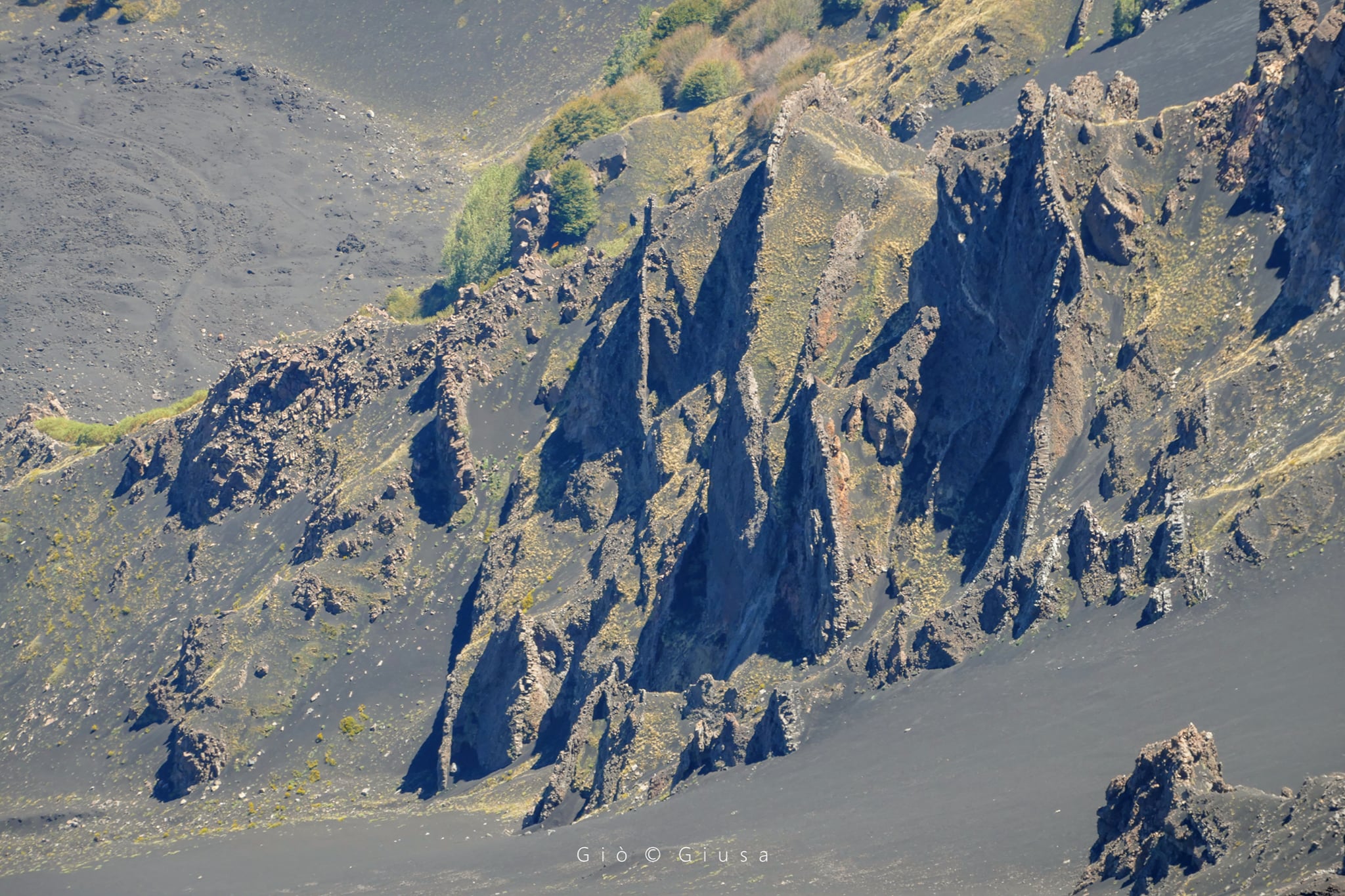
The Valle del Bove and its dykes.
VOLCANOLOGICAL OBSERVATIONS:
During the week, the monitoring of the volcanic activity of Etna was carried out by analyzing the images of the network of surveillance cameras of the INGV section of Catania, Osservatorio Etneo (INGV-OE), and an inspection performed in the summit area on August 13.
The week was characterized by Strombolian activity and a Southeast Crater (SEC) lava fountain episode, occasional ash emissions at the Northeast Crater (NEC), a
ordinary degassing at the crater of Bocca Nuova (BN) and fumarolic degassing at the crater of Voragine (VOR).
In particular, from the early hours of August 9, Strombolian activity resumed at the level of the Southeast Crater accompanied by a first lava overflow from the eastern vent to the east along the western wall of the Valle del Bove. Beginning at 00:40 UTC there is an increase in Strombolian activity and the gradual transition to lava fountain activity which produces an eruptive column which disperses in a south-easterly direction. From around 01:50 UTC we observed the establishment of a second lava flow which was propagating in a southwest direction then a third lava flow generated by an effusive vent open in the South base. East of the cone. The activity of the lava fountain ends around 04:00 UTC and has generally caused the relapse of pyroclastic materials on the south-eastern flank affecting the towns between Lavinaio and Zafferana up to the coast between Acireale and Pozzillo. The lava flows during the day of August 9 were weakly supplied, settling at an altitude of about 2,900 m above sea level, and during the day of August 10, the emission of lava ceased.

During the week, the Northeast Crater (NEC) produced isolated episodes of emission of fine and reddish ash. In particular, the most energetic event was recorded at 07:20 UTC on August 10 with the formation of an ash column which reached a height of about 6000 m dispersed to the east, which caused a weak fine ash fall in Zafferana. During the same day, the Northeast Crater (NEC) was affected by discontinuous and weak ash emissions which were repeated occasionally throughout the week in question and which did not form clouds. significant volcanics.
Finally, the Bocca Nuova Crater (BN) produced pulsed and discontinuous degassing from the two currently active vents. Finally, the activity of the Voragine crater (VOR) was characterized by fumarolic degassing.
Source : INGV.
Photos : Gio Giusa.
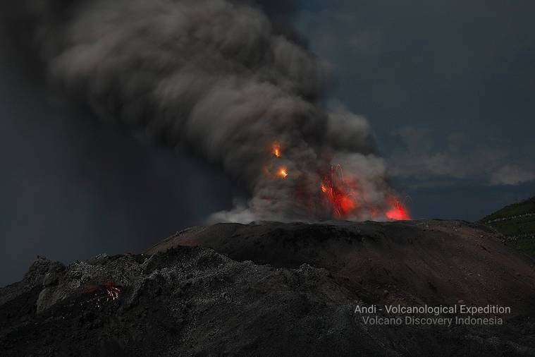
Indonesia , Ibu :
The level of activity has been level II (WASPADA) since December 10, 2013. The Ibu volcano (1340 m above sea level) has been in continuous eruption since 2008. The eruption produces emissions of pieces of rock and ash which accumulate in the crater.
The volcano was clearly visible until it was covered in fog. The smoke from the main crater is white and gray with low intensity, medium to thick, about 200-800 meters above the summit. The weather is sunny to rainy, the wind is weak to moderate in the North and West.
According to the seismographs of August 17, 2021, it was recorded:
62 eruption earthquakes / explosions
102 avalanche earthquakes
25 earthquakes of emissions
124 Harmonic tremors
4 distant tectonic earthquake.
VOLCANO OBSERVATION NOTICE FOR AVIATION – VONA.
Issued: August 17, 2021
Volcano: Ibu (268030)
Current Aviation Color Code: ORANGE
Previous Aviation Color Code: orange
Source: Ibu Volcano Observatory
Notice Number: 2021IBU13
Location of the volcano: N 01 deg 29 min 17 sec E 127 deg 37 min 48 sec
Area: North Maluku, Indonesia
Summit Elevation: 4240 FT (1325 M)
Summary of volcanic activity:
Eruption with volcanic ash cloud at 22:57 UTC (07:57 local)
Height of volcanic clouds:
Best estimate of ash cloud top is around 6800 FT (2125 M) above sea level, may be higher than can be seen clearly. Source of height data: ground observer.
Other information about volcanic clouds:
Gray ash cloud moving west
Remarks :
Eruption and ash emission continues
Sources : PVMBG, Magma Indonésie .
Photo : Andi Rosati / Volcanodiscovery.
Colombia , Nevado del Ruiz :
Weekly activity bulletin of the Nevado del Ruiz volcano
The activity level continues at: Yellow activity level or (III): Changes in the behavior of volcanic activity.
Regarding the monitoring of the activity of the Nevado del Ruiz volcano, the COLOMBIAN GEOLOGICAL SERVICE reports that:
Seismicity related to fluid dynamics inside volcanic conduits showed an increase in the number of recorded earthquakes and maintained similar levels in the seismic energy released compared to the previous week. There are records of an increase in the number of tremor pulses and long-period type earthquakes.The energy of the continuous volcanic tremor and tremor pulses is similar to that recorded the previous week. Very long-lived earthquakes have also been recorded. The earthquakes were located mainly in the Arenas crater. Some of these signals were associated with ash emissions, confirmed by the cameras installed in the area of the volcano and by the report of the officials of the Los Nevados National Natural Park.
The seismicity generated by the fracturing of the rock increased in number of earthquakes and in seismic energy released compared to the previous week. A seismic increase in this type of
activity recorded on August 15 and 16 in the West-South-West sector of the Arenas crater, the depths varied between 4.5 and 6.5 km. The highest magnitude recorded during the surge and the largest of the week was 1.4 ML (local magnitude), at 11:50 a.m. (local time), located 6.0 km west-south -West of Arenas crater, 5.0 km deep. The other seismic activity recorded during the week was located mainly in the South-East, South-South-West sectors and in the Arenas crater. The depths of the earthquakes ranged from 0.1 to 8.2 km.
Source et photo : SGC.
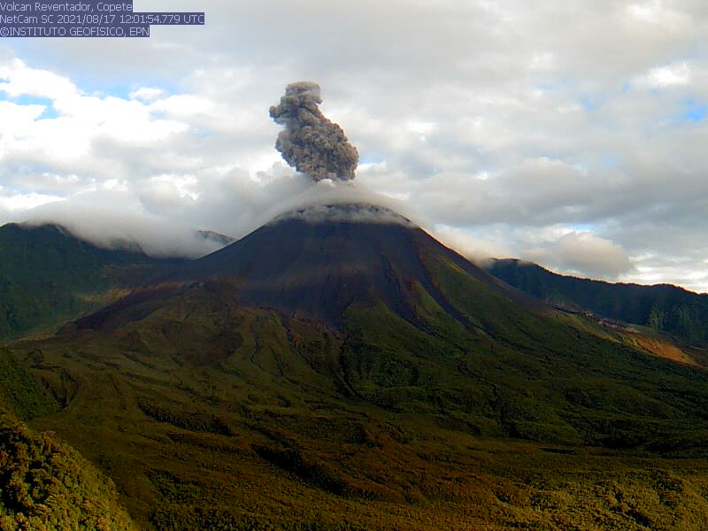
Ecuador , Reventador :
DAILY REPORT OF THE STATE OF THE REVENTADOR VOLCANO, Tuesday August 17, 2021.
Information Geophysical Institute – EPN.
Surface activity level: High, Surface trend: No change.
Internal activity level: Moderate, Internal trend: No change.
Seismicity: From August 16, 2021, 11:00 a.m. to August 17, 2021, 11:00 a.m.
The seismic reference station for seismic statistics has been operational for the last 24 hours.
Explosions (EXP): 99 events
Long period type events (LP): 72
Tremors of emissions (TREMI): 8.
Harmonic Tremors (TRARM): 3
Rains / lahars: At night, rains were recorded in the area which did not generate any news.
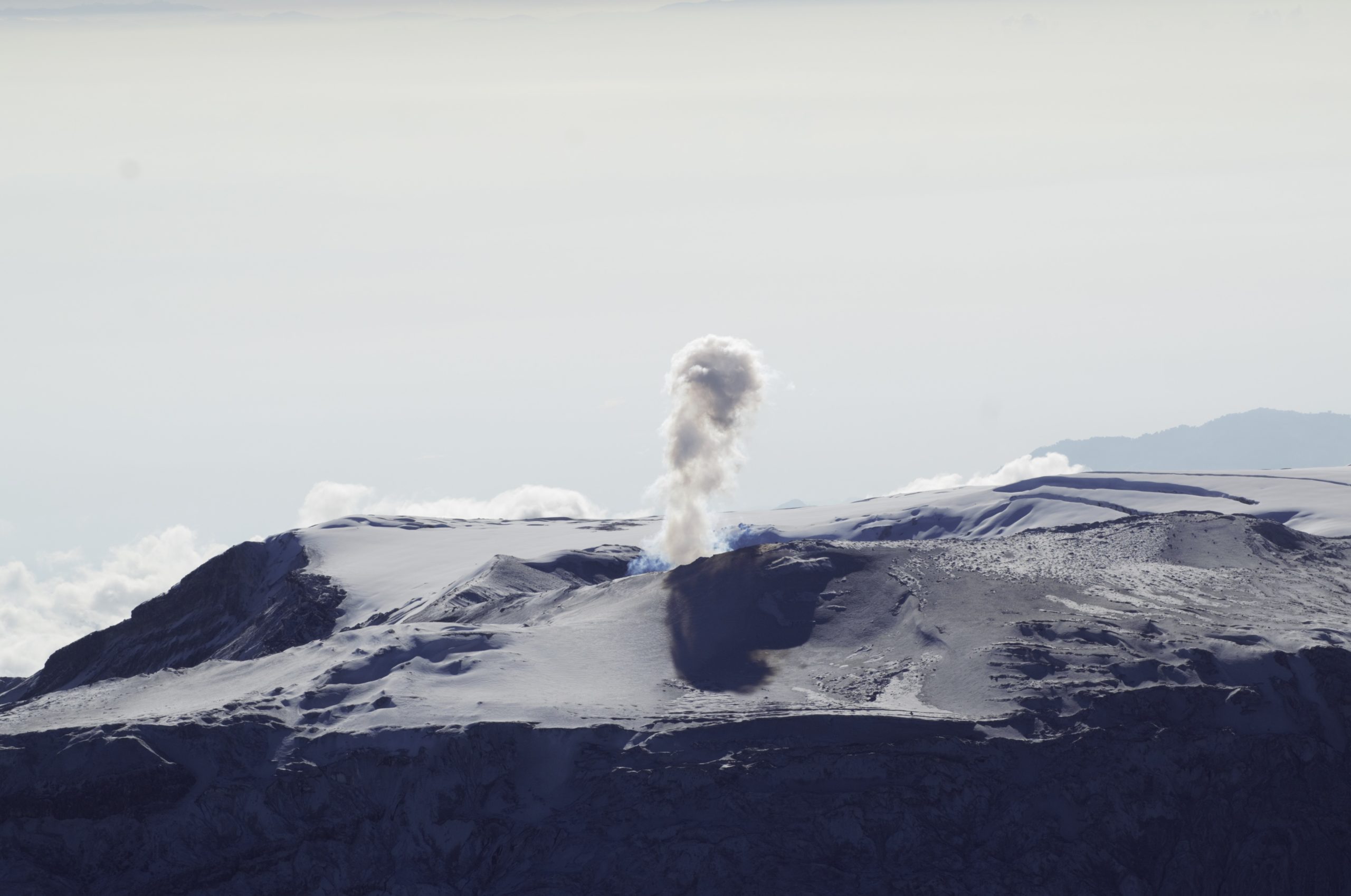
Emission / ash column: During the last 24 hours, several ash emissions were observed towards the West and North-West, the heights varied between 500 and 1000 meters above the level of the crater. The Washington VAAC reported 3 alerts of emissions observed on satellites, their direction was maintained towards the West and the heights did not exceed 1000 meters above the level of the crater.
Other monitoring parameters: There was no change in the other monitoring parameters and no thermal alert was recorded for this volcano.
Observations: In the afternoon and night of yesterday, the volcano was cleared and the emissions already described were observed. At night, an incandescence was observed in the crater as well as the rolling of boulders along the northeast flank of the volcano. The lava flow on the northeast flank continues to be active. Today during the morning the volcano has become cloudy.
Alert level: Orange.
Source et photo : IG-EPN
Mexico , Popocatepetl :
August 17, 11:00 a.m. (August 17, 4:00 p.m. GMT)
Over the past 24 hours, according to the monitoring systems of the Popocatepetl volcano, 97 exhalations of water vapor and gas have been recorded, sometimes accompanied by ash and an explosion yesterday at 3:44 p.m. In addition, 611 minutes of low and medium amplitude tremor were recorded.
During the night, an incandescence could be observed above the crater.
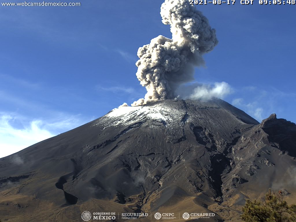
At the time of this report, the volcano is observed with a slight emission of water vapor and gas heading west.
CENAPRED recommends NOT TO APPROACH the volcano and especially the crater, because of the danger of falling ballistic fragments and, in the event of heavy rains, to stay away from the bottom of the ravines because of the danger of mudslides and debris.
The Popocatépetl volcanic traffic light is in PHASE 2 YELLOW.
Source et photo : Cenapred.