May 02 , 2021.
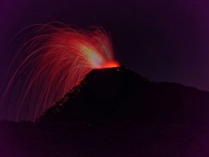
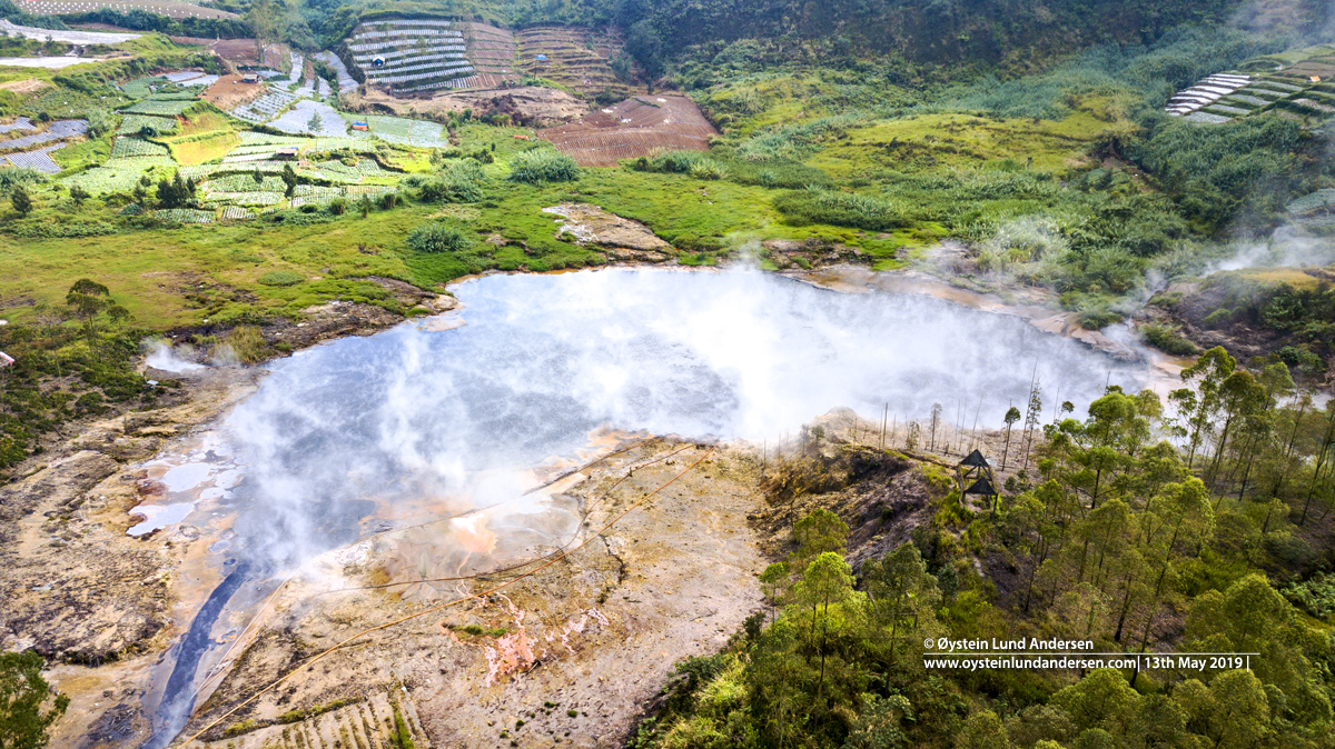
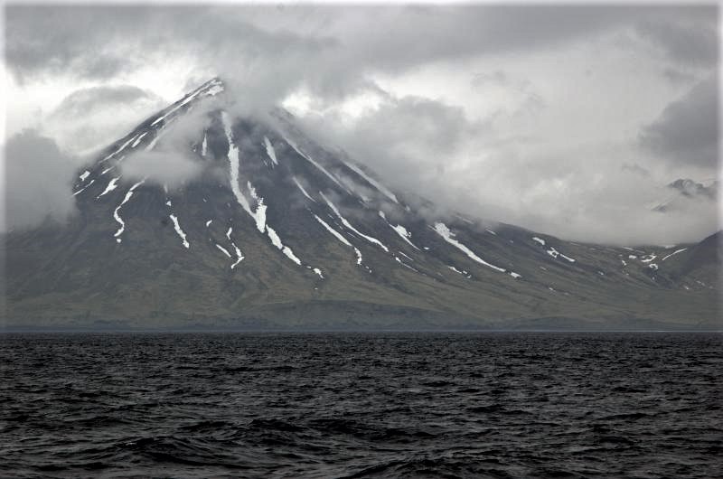
Indonesia , Dieng Plateau / Sileri Crater :
G. Dieng is a volcanic complex with volcanic activity spread over 16 craters. Currently, monitoring is carried out on 2 (two) main craters which are the most active, namely the Sileri Crater and the Kawah Weigh. The volcanic activity of the Mount Dieng complex was observed visually and instrumentally from the Volcano Observation Post (PGA) in Karangtengah Village, Batur District, Banjarnegara Regency, Central Java Province. The last phreatic eruption occurred on April 1, 2018.
The activity level of G. Dieng has been level I (normal) since October 2, 2017.
Surveillance data:
Visual:
During the period from January 1 to April 29, 2021, the volcano was clearly visible until it was covered in fog. It was observed that the white smoke from the Sileri crater was weak, medium to thick, about 1 to 70 meters above sea level from the bottom of the crater. On April 29, 2021 at 6:25 p.m. WIB, a phreatic eruption occurred causing material to burst 400 m to the south (200 m for rocky material and 400 m for mud), to the east (200 m for rocky material and 300 m for mud), and westwards up to 200 m in the form of mud. The height of the mudslide was not observed as it occurred at night.
Seismicity:
The number and types of earthquakes recorded from January to April 29, 2021 consisted of:
30 Tornillo-type earthquakes,
147 local tectonic earthquakes,
2 earthquakes felt,
31 distant tectonic earthquakes
48 deep volcanic earthquakes.
On April 29, 2021, an eruption earthquake was recorded at 6:25 p.m. WIB with a maximum amplitude of 42.7 mm and an earthquake duration of 108.15 seconds.
Analysis:
The eruption that occurred was phreatic in nature, not preceded by a significant increase in volcanic earthquakes, indicating the lack of surface magma supply. The eruption that occurred on April 29, 2021 was caused more by overpressure and surface activity.
The eruptions lasted only briefly, not followed by an increase in seismicity and visual changes leading to a larger series of eruptions.
Potential danger:
Given the nature and character of G. Dieng eruptions, currently the potential for phreatic eruptions may still occur without being preceded by increased visual activity or seismicity. Potential dangers come in the form of rock shards and mud around the crater.
Source : PVMBG.
Photo : Øystein Lund Andersen
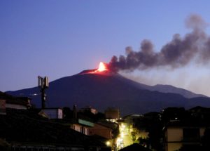
La Réunion Island , Piton de la Fournaise :
Press release of May 01, 2021 – 7:00 a.m.
The eruption that started on 04/09/2021 at 7 p.m. (appearance of the tremor) continues. The intensity of the volcanic tremor (indicator of a surface lava emission) stopped its slow decrease and is
relatively stable for two days.
– No direct observation of the eruptive site could be made today given the very bad weather conditions on the volcano.
– Over the past 24 hours, a single superficial volcano-tectonic earthquake (between sea level and the surface) has been recorded, located directly above the summit craters.
– The CO2 fluxes in the soil are always increasing in the far field (Plains region).

– A slight inflation (swelling) of the summit area and the base of the terminal cone seems to be emerging. This parameter will be monitored over the next few days because it may correspond to the pressurization of the superficial magmatic reservoir located under the summit and could suggest a deep magma flow entering the superficial magmatic reservoir greater than the outlet flow of the reservoir which supplies the eruptive site.
– Due to bad weather conditions on site, no flow estimate could be made in recent days.
– Finally, the very bad weather conditions on the volcano (precipitation and thunderstorms) for more than two weeks have strongly impacted the OVPF surveillance network. Thus 17 sensors (16% of the OVPF network), including 12 located in the eastern sector of the volcano, are no longer fully operational due to lack of energy (not enough sunlight to recharge the batteries for two weeks) or lightning strikes.
Alert level: Alert 2-2
Source : OVPF.
Alaska , Semisopochnoi :
51°55’44 » N 179°35’52 » E,
Summit Elevation 2625 ft (800 m)
Current Volcano Alert Level: WATCH
Current Aviation Color Code: ORANGE
SO2 and (or) low-level ash emissions from Semisopochnoi were observed in satellite views on Saturday, Sunday, and Monday of this past week. Those plumes generally drifted to the south at altitudes of roughly 10,000 ft above mean sea level. Generally cloudy conditions prevailed for the rest of the week, obscuring most satellite views of the volcano. No activity was detected by regional infrasound arrays. AVO will continue to monitor the situation closely.
Small eruptions producing minor ash deposits within the vicinity of the volcano are typical of activity during unrest at Semisopochnoi since September 2018. Local seismic stations have been offline since November 11, 2020. New explosions could occur at any time with no warning.
Semisopochnoi is monitored remotely by satellite and lightning detection sensors. An infrasound array on Adak Island may detect explosive emissions from Semisopochnoi with a slight delay (approximately 13 minutes) if atmospheric conditions permit.
Remote Semisopochnoi volcano occupies the largest, young volcanic island in the western Aleutians. The volcano is dominated by an 5-mile (8-km) diameter caldera that contains a small lake and a number of post-caldera cones and craters. The age of the caldera is not known with certainty but is likely early Holocene. Prior to 2018, the previous known eruption of Semisopochnoi occurred in 1987, probably from Sugarloaf Peak on the south coast of the island, but details are lacking. Another prominent, young post-caldera landform is Mount Cerberus, a three-peaked cone cluster in the southwest part of the caldera. The island is uninhabited and part of the Alaska Maritime National Wildlife Refuge. It is located 40 miles (65 km) northeast of Amchitka Island and 130 miles (200 km) west of Adak.
Source et photo : AVO.
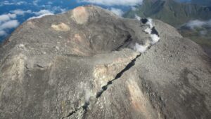
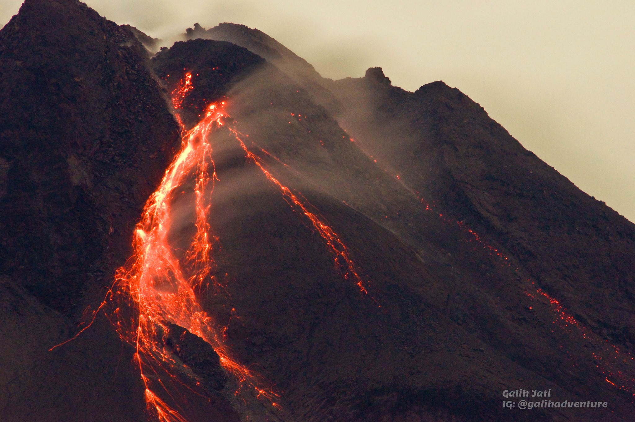
Indonesia , Merapi :
Mount Merapi activity report from April 23 to 29, 2021
I. OBSERVATION RESULTS
Visual
The weather around Mount Merapi is generally sunny in the morning and at night, while the afternoon until evening is foggy. There is white smoke, thin to thick with low pressure. A maximum smoke height of 450 m was observed from the Ngepos observation post on April 26, 2021 at 5:40 a.m. WIB.
Warm avalanche clouds occurred 12 times with an observed slide distance of 2000 m to the southwest and 700 m to the southeast, recorded on a seismogram with a maximum amplitude of 58 mm and with a duration of 163 seconds. Lava avalanches have been observed 113 times with a maximum slide distance of 2000 meters to the southwest.
The volume of the lava dome in the southwest sector is 1,141,850 m3 with a growth rate of 11,900 m3 / day. Morphological analysis of the summit area based on photos of the Southeast sector from April 22 to April 28, 2021 shows that the volume of the central dome is 1,794,000 m3.
Seismicity
This week, the seismicity of Mount Merapi recorded:
12 hot cloud avalanches (AP),
11 shallow volcanic earthquakes (VTB),
102 multi-phase earthquakes (MP),
992 avalanche earthquakes (RF),
16 emission earthquakes (DG)
6 tectonic earthquakes (TT).
The seismic intensity this week is relatively the same as last week.
Deformation
The deformation of Mount Merapi which was monitored using EDM this week showed a shortening rate of 0.5 cm / day.
Rain and lahars
This week there was rain at the Mount Merapi observation post with a low rainfall intensity of 3mm / hour for 70 minutes at Babadan post on April 27, 2021. There were no reports of lahars or additional flows in the rivers that descend from the G Merapi.
Conclusion
Based on the results of visual and instrumental observations, it is concluded that:
The volcanic activity of Mount Merapi is still quite high in the form of effusive eruption activity. The activity status is defined at the « SIAGA » level.
Source : BPPTKG.
Photo : Yohannes Tyas Galih Jati
Guatemala , Pacaya :
Once again, the Pacaya volcano has defeated the local authorities of San Vicente Pacaya. The volcano had put an end to a strong eruptive activity of nearly three months last Friday which held the country in suspense, in particular because of the lava which arrived about 450 meters from the first inhabited houses in the villages of El Rodeo and El Patrocinio , nestled on the sides of the volcano.
This Friday, almost a week later, a new fissure occurred to the northwest in front of Cerro Chino, which caused an increase in the expulsion of lava. However, the lava is moving southwest as announced by Francisco Juarez, deputy director of insivumeh.
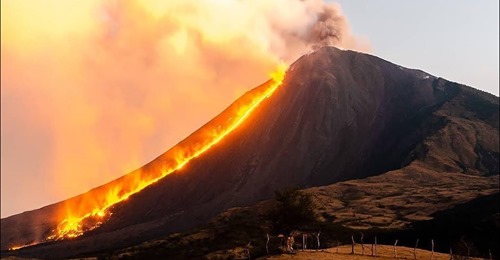
The route of the flow goes to the Breña farm in San Vicente Pacaya, which keeps the authorities on alert to take the respective preventive measures. Until now, it has been asked to avoid the entry of tourists into the Pacaya National Park and thus avoid climbing this volcano due to the strong eruptive activity it maintains.
ACTIVITY:
Mackenney Crater is observed with a white fumarole, moving low to the south. Effusive activity continues in the fissure on the northwest flank, which feeds a lava flow that descends to the southwest flank, over a length of approximately 1700 meters, with two fronts in the Breña region. The activity recorded and observed is completely effusive, however there is a probability of generating explosions in the crack and the Mackenney crater. PCG’s seismic stations record tremors (internal vibration) associated with the rise of magma, and the displacement of lava flows.
Source : relax TV , Insivumeh .
Photo : Ultramix TV.